.JPG/300px-France,_Marne,_Sainte-Menehould_(1).JPG) | ||
| Sainte-Menehould | ||
| region | Grand Est | |
|---|---|---|
| Residents | 4.150 (2018) | |
| height | 139 m | |
| no tourist info on Wikidata: | ||
| location | ||
| ||

Sainte-Menehould (official spelling, also Sainte-Ménehould or Sainte Ménéhould) is a small town in French Department Marne in the region Grand Est (historical region: Champagne-Ardenne). The city on the upper reaches of the Aisne is the seat of a sub-prefecture.
background
After St. Ménehould (Manechildis), consisting of the upper town and the lower town, is located on the western edge of the Argonne Forest (L'Argonne), which borders the plains of Champagne to the east and forms the landscape border with Lorraine and thus the historical eastern border between France and the Holy Roman Empire . The fortifications of the upper town (Butte) were under Blanche de Navarre Erected at the beginning of the 13th century and by Girolamo Marini, the Bolognese architect, reinforced in the 18th century. In 1791, the French King Louis XVI. and Queen Marie-Antoinette on the run from the French Revolution (according to legend while eating the local specialty pork foot) recognized here and arrested shortly afterwards in nearby Varennes-en-Argonne. During the coalition wars in 1793, a battle took place in nearby Valmy, which contributed greatly to the consolidation of revolutionary France. During the First World War, the Argonne Forest was the scene of fierce trench warfare.
getting there
By plane
The cheapest should be Paris-Charles de Gaulle Airport be.
By train
With the TGV Est to Meuse TGV, from there by bus over Verdun. Or with the TER from Paris-Est to Châlons-en-Champagne, from there by bus (transfer time around 50 minutes). The station has been closed for a long time.
By bus
In the street
The city is 3 km north of the Autoroute A4 (exit 29), the Strasbourg With Paris connects (access also from Saarbrücken via the A 320 / Europastraße 50). If you want to save yourself the motorway toll, you can drive on the former Route nationale 3 (now called Départementsstraße, in the Marne D 3 department) (speed limit generally to 80 km / h).
By boat
The city is not on any navigable body of water. To the navigable Meuse in Verdun it is around 40 km.
By bicycle
mobility

- Parking is available, for example, on the Place du Général-Leclerc.
Tourist Attractions
.JPG/220px-Sainte-Menehould_-_église_Notre-Dame-du-Château_(07).JPG)
- That through Philippe de La Force erected town hall (Hôtel-de-Ville) from 1730 on the Place-du-Général-Leclerc.
- The museum Musée d'Art et d'Histoire also in this place.
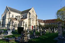
- The hill Butte du château the upper town with a rewarding view and the Notre-Dame-du-Château church from the 13th century with changes from the 15th and 18th centuries. The church has an organ from 1648.
activities
shop
The small town's specialty are theirs Pig's feet (pieds de cochon à la Sainte-Menehould). Also to be mentioned is the raw Ardennes ham. The craft beer from Valmy is also known.
kitchen
- Le Cheval Rouge, Rue Chanzy 1 (next to the town hall). Tel.: 33 326 608104. With 24 rooms.Price: Menu 24-65 EUR (2017).
nightlife
accommodation
- Le Cheval Rouge. See under kitchen.
- Demeure d'Argonne, at the Place du Général-Leclerc. 5 rooms.
health
Practical advice
trips
- The Argonne Forest with the Cistercian monastery La Chalade (the rose window in the west facade was transferred here from Verdun) and numerous remains of the trench warfare.
- Valmy with its famous (reconstructed) mill, 12 km west on the D 3.
literature
Web links
- http://www.ville-sainte-menehould.fr - Official website of Sainte-Menehould
- https://www.argonne.fr