| Triângulo Mineiro and Alto Paranaíba | |
 | |
Location 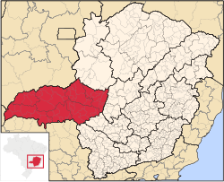 | |
| State | Brazil |
|---|---|
| Surface | 90,545 km² |
| Inhabitants | 2.092.131 (2006 census) |
Triângulo Mineiro and Alto Paranaíba is a region of the state of Minas Gerais in Brazil.
To know
This pasture-rich region boasts some of the best beef and dairy cattle in the country.
Geographical notes
The territory is bordered by the Serra da Canastra and Marcela to the east, to the south by the state of St. Paul, north of that of Goiás, and to the west by the confluence of the Paranaíba and Grande rivers. The name Triângulo (in Italian: triangle) derives precisely from the triangular shape of the confluence of these rivers.
Territories and tourist destinations
It is divided into 7 micro-regions:
- Araxá
- Frutal
- Ituiutaba
- Patos de Minas
- Patronage
- Uberaba
- Uberlândia
Urban centers
- Araguari - There are numerous lakes formed by an immense hydroelectric power station, where it is also possible to fish and practice water sports.
- Araxá - Located at over 900m, and famous for its spas.
- Ituiutaba - It is located on the promontory of the Triangulo Mineiro. Its carnival is considered to be the most exciting of Minas Gerais.
- Patos de Minas - Among the Brazilian cities with the highest quality of life.
- Patronage - Near a huge crater of 16 km in diameter of dubious origin (volcanic or meteoritic).
- Santa Vitória - Hill town (500 m) founded in the early nineteenth century.
- Uberaba - 19 km from the important archaeological site of Peirópolis.
- Uberlândia - The second city of the State of Minas Gerais, which abounds in tourist attractions, both for architectural, cultural and natural value.
How to get
How to get around
What see
What to do
At the table
Safety
Other projects
 Wikipedia contains an entry concerning Triângulo Mineiro and Alto Paranaíba