| Trás-os-Montes and Alto Douro | |
 | |
Location 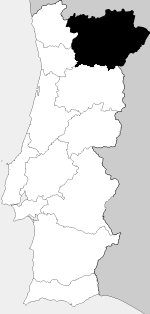 | |
| State | Portugal |
|---|---|
Trás-os-Montes and Alto Douro is a territory of Northern Portugal.
To know
Territories and tourist destinations
Urban centers
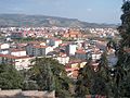
- Braganza (Bragança) - Historic regional capital, Braganza, the ancient Roman Juliobriga, is famous as the place of origin of the homonymous family whose exponents reigned over the Portugal from 1640 until 1910, the year in which, following a revolution, the Republic was proclaimed. Braganza today it presents itself to visitors with a well-preserved historic center surrounded by walls.
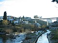
- Chaves - Small spa on the Rio Tâmega, Chaves it is located a few km from the border with the Spain and is famous for a Roman bridge with 16 arches built at the time of the emperor Trajan.
- Lamego - City with a medieval core of intricate alleys, Lamego it is also famous for a baroque staircase that leads to the sanctuary of Nossa Senhora dos Remédios.
- Miranda do Douro - Nicknamed "Cidade Museu", Miranda do Douro is an ancient village that dominates the gorges of the Douro river, on the border with the Spain. Due to its strategic position, it was fortified but was occupied for a long time by the Castilian army at the end of the fourteenth century and a second time in 1763 by the armies of the Spanish king Charles III.
- Mirandela
- Mondim de Basto - Village from which you access the Alvão Natural Park, described later.
- Peso da Régua - Town on the Douro, once an important river port for the export of wine.
- Pinhão - Famous for the terraced vineyards from which fine wines are made.
- Vila Nova de Foz Côa - Access point to the rock art park of Vale do Côa.
- Vila Real - City famous for the production of Mateus wines and for the Baroque style palaces in estates aimed at viticulture.
Other destinations
- Montesinho Natural Park (Parque Natural de Montesinho) - 750 m² park on the mountains that mark the north-eastern border with Spain, accessible from the village of the same name. Its landscapes are characterized by extensive woods, especially oak woods, and deep gorges. The tiny villages with slate-roofed houses located within the park are also very pretty.
- Alvão Natural Park - A small park (72 km²) in the surroundings of Vila Real with varied landscapes, rocky but also very green, among a series of tributaries of the Douro which in their upper course form small waterfalls. Villages within the park are Ermelo, near which there are the homonymous waterfalls (Fisgas de Ermelo) is Lamas de Ôlo, on the river of the same name and at an altitude of almost 1000 m.
- Do Douro Internacional Natural Park - 850 m² park spread over the gorges formed by the Douro River near the border with Spain. It is accessible from the centers of Miranda do Douro and Castelo Branco.


.JPG/120px-Miranda_do_Douro_10_(cropped).JPG)


How to get
.jpg/220px-CP_592_(21576681349).jpg)
Douro Valley Railway
On the train
The region is crossed by a single stretch of railway:
- Linha do Douro (Douro railway). The railway is of great tourist importance as it crosses the Alto Douro wine region (Região Vinhateira do Alto Douro), which is part of the world heritage of humanity. It offers spectacular views of the terraced hills that border the valley thanks to numerous viaducts and bridges, several of considerable height. The railway track is 160 km long and ends at the village of 1 Pocinho. From this terminus you have two possibilities: continue by car or by other means up to Douro International Natural Park or head to the neighboring one Vale do Côa, one of the largest open-air rock art sites dating back to between 20,000 and 10,000 years ago.


How to get around
What see
What to do
At the table
Safety
Other projects
 Wikipedia contains an entry concerning Trás-os-Montes and Alto Douro
 Commons contains images or other files on Trás-os-Montes and Alto Douro