 Rock tomb in the necropolis of Abu Sir al-Malaq | ||
| no picture on Wikidata: | ||
| Abū Ṣīr el-Malaq · أبو صير الملق | ||
| Governorate | Beni Suef | |
|---|---|---|
| Residents | 19.532 (2006) | |
| height | 30 m | |
| no tourist info on Wikidata: | ||
| location | ||
| ||

Abu Sir el-Malaq, also Abusir el-Meleq or Būṣīr Qūrīdus / Qūreidis, Arabic:أبو صير الملق, Abū Ṣīr al-Malaq, is a village and an archaeological site in the egyptian Governorate Beni Suef on the west side of the Nils, about 19 kilometers north of 1 Beni Suef![]()
![]()
![]() and 90 kilometers south of Cairo. The place is of cultural and historical significance, but only has the monastery of St. Georg is a notable sight on site. Finds from the local ancient Egyptian cemetery are exhibited in several European museums.
and 90 kilometers south of Cairo. The place is of cultural and historical significance, but only has the monastery of St. Georg is a notable sight on site. Finds from the local ancient Egyptian cemetery are exhibited in several European museums.

background
location

2 Abū Ṣīr el-Malaq![]()
![]()
![]() is located on the west side of the Nile, still in the fruit fringes. It's just under three kilometers to the western desert and twelve kilometers to the Nile. Nearby places are about nine kilometers to the northeast 3 Qiman el-ʿArūs
is located on the west side of the Nile, still in the fruit fringes. It's just under three kilometers to the western desert and twelve kilometers to the Nile. Nearby places are about nine kilometers to the northeast 3 Qiman el-ʿArūs![]()
![]() , which is located 15 kilometers northeast 4 el-Wāsṭā
, which is located 15 kilometers northeast 4 el-Wāsṭā![]()
![]() , the one about eight kilometers southeast 5 Dalāṣ
, the one about eight kilometers southeast 5 Dalāṣ![]()
![]()
![]() , the one about twelve kilometers southeast 6 Nāṣir
, the one about twelve kilometers southeast 6 Nāṣir![]()
![]() (formerly Būsch) and the monastery nine kilometers to the west 7 Deir el-ammām
(formerly Būsch) and the monastery nine kilometers to the west 7 Deir el-ammām![]()
![]() . The Būsch Airbase of the Egyptian Air Force is located about twelve kilometers to the southwest.
. The Būsch Airbase of the Egyptian Air Force is located about twelve kilometers to the southwest.


The village extends from northwest to southeast over a distance of about one and a half kilometers. To the west and southwest of the village is an extensive ancient Egyptian necropolis (cemetery).
history
Abū Ṣīr el-Malaq is one of several villages of the name Abū Ṣīr. What they have in common is that the name derives from the Greek Bousiris (Busiris), Βουσῖρις, derives. The Greek name was used from around the 3rd century BC to the 6th century AD. For its part, Bousiris is derived from the ancient Egyptian word Pr-Wsjr from. Abū Ṣīr el-Malaq was thus the place of worship of the god Osiris. The village itself has been inhabited since prehistoric times.
Scientific digs have only taken place at the end of the 19th and beginning of the 20th century. British Egyptologist William Matthew Flinders Petrie (1853–1942) briefly mentioned two coffins found on site in 1889.[1] Tombs from different eras were made from 1902 to 1904 by classical archaeologists Otto Rubensohn (1867–1964) found while searching for papyri and papyrus cardboard.[2] From 1905 to 1906 the extensive burial ground of Abū Ṣīr al-Malaq was under the direction of the German Egyptologist Georg Möller (1876–1921) on behalf of German Orient Society exposed. About 850 were examined mainly prehistoric (Predynastic) graves from the Naqada II and Naqada III periods, about 3250-3050 BC The corpses from this period were buried in about one meter deep oval and rectangular pits in a crouched position, lying on the left side. Ceramic and stone vessels, flint tools, ointment vessels and meat offerings, rare jewelry, cylinder seals and club heads were added.
Furthermore, graves were made from the Hyksos time in the Second intermediate time with scarabs, priestly graves from the Late period and graves from Greco-Roman times examined. The deceased were buried in wooden post and box coffins, limestone sarcophagi and cardboard coffins with mummy masks (some as inner coffins). The place name of Lower Egyptian / northern Abydos was also known from the coffin scripts:[3] the god Osiris was nicknamed Lord of the Lower Egyptian Abydos. The finds include mummy boxes, jars and figures. Some of these finds are now in the Martin von Wagner Museum in Wurzburg. The pristine tomb of Tadja from the 25th Dynasty is now in the Egyptian Museum in Berlin.

Limestone canopic jugs from the 19-21. Dynasty, Würzburg

Mummy mask, 4th century BC Chr., Würzburg

Cardboard box, 4th century BC Chr., Würzburg
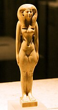
Tadja, ivory, Berlin


In the area of the village mosque there were blocks of one Temple of Ptah-Sokar-Osiris from the time Nectanebos ’II. from the 30th dynasty found. These temple blocks are the only evidence of a settlement near the cemetery. Possibly the settlement is buried under the village or neighboring villages. Rubensohn described a bronze jug with a spout in the shape of a crowing cock from the beginning of the Byzantine period as a special find.[2]
The cemetery had been looted since the second half of the 19th century in order to earn money by selling the artifacts. E.g. Rubensohn mentioned[2] a robbery excavation around 1893 and the Austrian Egyptologist Günter Vittmann (born 1952) Robbery excavations in 1972 and 1973.[4][5] In recent times, too, in the 2010s, there were again robbery excavations, so that the area looks like a Swiss cheese on satellite images today.
Abū Ṣīr el-Malaq is in greek papyri documented between the third century BC and the sixth century AD. In the early Roman times around the turn of the times, priests and prophets, among others, were on site. worked for the gods Apollo, Asklepius, Isis and Sarapis. It may be that of the Egyptian bishop John of Nikiu (7th century) in his chronicle described place called Busiris around the local settlement, which was established by a certain Māṭūnāwīs.[6]
According to tradition, this was the last one Umayyads-Caliph Marwān II. (Reign 744-750) after he was buried here on his flight from Syria on the 27th Dhu ’l-Hiddscha 132 AH (= August 6, 750) was killed.[7] But from his burial place are no There are more remains, even if the existence of the grave near Abū Ṣīr el-Malaq was reported in Baedek Egypt from 1928.[8] The Coptic writer Abū el-Makārim (Late 12th, early 13th century) knew the following to report about Būṣīr Qūrīdus and the killing of Marwan II:
- “Būṣīr Qūrīdus. In this city lived a magician named Būṣīr [d. i. Osiris], who was in the service of Pharaoh, [and] who had magical powers. It was here that Marwān ibn Muḥammad al-Ǧaʿdī, the last Umayyad caliph, was killed. ʿAlyūn the heretic was also killed here. In this area [Būṣīr Qūrīdus] there is a church of the Lady and Pure Virgin Mary and a monastery named after Abīrūn[9], into which Marwān, the “donkey of war,” which has already been spoken of, had come. He was the last of the Umayyad caliphs; and he was from the Khorasans[10], the followers of the as-Saffāḥ, the Abbasids, tracked. And they seized him, crucified him upside down; and they also killed his vizier. "[11]
This description of Abū el-Makārim is the only one that names a church or monastery in Abū Ṣīr el-Malaq. That is why it is sometimes suggested that the monastery may be nine kilometers to the west Deir el-ammām could act. Unfortunately, Abū el-Makārim mentions another place in another part of his work, the island of el-Asmunein, where Marwān II is said to have been killed.
As with most Egyptian villages, she lives population nowadays mainly from agriculture. In 1886 there were 1,886 inhabitants plus 511 Bedouins in this village,[12] 19,532 according to the 2006 census.
getting there
The journey takes place mostly from Beni Suef from the north on trunk road 02. You can go to Nāṣir, Dalāṣ or Qiman el-ʿArūs drive and cross the villages in a westerly direction. In the case of the first two localities, continue in a north or north-westerly direction, in the case of Qiman el-ʿArūs to the southwest. The roads through the fruitland mostly follow canals. At 1 29 ° 14 '52 "N.31 ° 6 ′ 36 ″ E you branch off to the west and reach the village after about two kilometers. You have to cross the village: both the monastery and the archaeological site are to the west just outside the village.
A slope in the west of the village leads to the monastery and the cemetery.
Taxis or Tuqtuqs can be found in Beni Suef and Nāṣir.
mobility
The monastery and the archaeological site can be explored on foot. You can park your vehicle at the monastery.
Tourist Attractions
monastery

The Church of St. Georg has three aisles. The central nave, which is separated from the neighboring ones by pillars, is significantly wider. In front of the altars for Abū Seifein (Merkurius, left), St. George and St. Virgo there is a modern screen wall with the icons of six apostles each in the side aisles and the Last Supper and the cross in the central nave. On the left side of the iconostasis there are icons for the Archangel Michael, Mary and the Holy Spirit, in the middle Mary with her child and Jesus and on the right for St. Mark and an angel with the head of John the Baptist.

Monastery of St. George

Inside the Church of St George
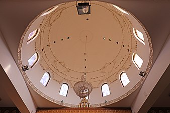
Dome of the Church of St George
Relic of St. George


Immediately in front of the iconstasis there is a large dome in the central nave. The undecorated dome has twelve lead glass windows with portraits of the twelve apostles, additional light openings, patterns made with bricks and a chandelier.
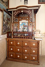
On the side walls are icons with scenes from the life of Christ and biblical scenes. In the north-west corner of the church there is a shrine with a relic of St. George and on the southern back wall a shrine with relics of martyrs from the Faiyūm and from Achmīm.
The church's bell tower was still under construction in 2017.
necropolis
To the west and south of the monastery there is an extensive prehistoric and pharaonic, but inaccessible 3 necropolis(29 ° 14 '47 "N.31 ° 5 ′ 1 ″ E). The burial ground extends over a length of four kilometers and a width of up to 400 meters. Many graves were driven into the rock or created as shafts, seldom provided with masonry mud brick structures. The archaeological site has been badly affected by the work of predatory graves. The area is guarded.
kitchen
accommodation
trips
The village can be seen along with the nearby villages Qiman el-ʿArūs, Dalāṣ, the city Nāṣir and the monastery Deir el-ammām visit.
Web link
- The prehistoric cemetery of Abusir el-Meleq, German Orient Society.
literature
- Prehistoric and Pharaonic times:
- : Abusir el-Meleq. In:Helck, Wolfgang; Otto, Eberhard (Ed.): Lexicon of Egyptology; Vol. 1: A - harvest. Wiesbaden: Harrassowitz, 1975, ISBN 978-3-447-01670-4 , Col. 28.
- : Abusir el-Meleq. In:Bard, Kathryn A. (Ed.): Encyclopedia of the Archeology of Ancient Egypt. London, New York: Routledge, 1999, ISBN 978-0-415-18589-9 , Pp. 91-93.
- : Excavations by the German Orient Society on the prehistoric burial ground of Abusir El-Meleq; 1: The archaeological results of the prehistoric burial ground of Abusir El-Meleq. Leipzig: Hinrichs, 1926, Scientific publications of the German Orient Society: WVDOG; 49. Temple blocks Nectanebo ’II. P. 102, plate 77.
- : Excavations by the German Orient Society on the prehistoric burial ground of Abusir El-Meleq; 2: The anthropological results of the prehistoric burial ground of Abusir El-Meleq. Leipzig: Hinrichs, 1915, Scientific publications of the German Orient Society: WVDOG; 27.
- Coptic and Arab times:
- : Abuṣir al-Malaq. In:Atiya, Aziz Suryal (Ed.): The Coptic Encyclopedia; Vol. 1: Abab - Azar. new York: Macmillan, 1991, ISBN 978-0-02-897023-3 , P. 37.
- : Būṣīr Qūrēdis. In:Christian Coptic Egypt in Arab times; Vol. 1: A - C. Wiesbaden: Reichert, 1984, Supplements to the Tübingen Atlas of the Middle East: Series B, Geisteswissenschaften; 41.1, ISBN 978-3-88226-208-7 , Pp. 465-467.
- : The churches and monasteries of Egypt and some neighboring countries attributed to Abû Sâliḥ, the Armenian. Oxford: Clarendon Press, 1895, Pp. 257 f. (Fol. 92.b: Būṣīr Qūrīdus), 221 (fol. 77.a: Insel el – Aschmūnein). Various reprints, e.g. B. Piscataway: Gorgias Press, 2001, ISBN 978-0-9715986-7-6 .
Individual evidence
- ↑: Illahun, Kahun and Gurob: 1889--1890. London: Nutt, 1891. Plate XXVIII.
- ↑ 2,02,12,2: Report on the excavations at Abusir el Mäläq in 1903. In:Journal of Egyptian Language and Antiquity (ZÄS), ISSN0044-216X, Vol.41 (1904), Pp. 1–21, doi:10.1524 / zaes.1905.4142.jg.1.
- ↑: The names of Upper and Lower Egypt and the names for north and south. In:Journal of Egyptian Language and Antiquity (ZÄS), ISSN0044-216X, Vol.44 (1907), Pp. 1–29, especially p. 28 f, doi:10.1524 / zaes.1908.4344.jg.177.
- ↑: To the robbery excavations in Abusir el-Meleq. In:Göttinger Miscellen: Contributions to the Egyptological discussion (GM), ISSN0344-385X, Vol.42 (1981), Pp. 81–86, two tables on p. 87 f.
- ↑: Hold on to the pyramids! : 5000 years of grave robbery in Egypt. Düsseldorf; Vienna: Econ, 1980, ISBN 978-3-430-12335-8 , P. 252 ff.
- ↑: Chronique de Jean, évêque de Nikiou: Texts Ethiopia. Paris: Impr. National, 1883, Pp. 224, 245.
- ↑: Le livre de l’avertissement et de la revision. Paris: Imprimerie Nationale, 1896, Pp. 404, 420-423. French translation of the work Kitāb at-Tanbīh wa-ʾl-išrāf.
- ↑: Egypt and the Sûdan: Handbook for Travelers. Leipzig: Baedeker, 1928 (8th edition), P. 210.
- ↑Coptic martyr, Coptic: Ⲡⲓⲣⲱⲟⲩ, Pirou, who during the Diocletian persecution of Christians together with his brother Athom, Ⲁⲑⲱⲙ, was beheaded. According to the Coptic Synaxar, both are am 8. Abib (Coptic Orthodox Church Network).
- ↑Coming from the Khorasan area in present-day Iran.
- ↑See literature.
- ↑: La geographie de l’Égypte à l’époque copte. Paris: Impr. National, 1893, P. 10.