| Marine Protected Area Plemmirio | |
 | |
Location 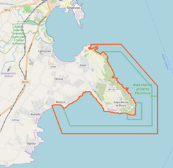 | |
| Area type | Protected sea area |
|---|---|
| State | Italy |
| Region | Sicily |
| Territory | Syracusan |
| Surface | 14.35 km² |
| Foundation year | 2004 |
| Institutional website | |
Marine Protected Area Plemmirio is a protected area located in Sicily.
To know
Geographical notes
The reserve is the stretch of sea around the Maddalena Peninsula, known as Plemmirio and located south of Syracuse. The reserve is divided into three zones: A, B and C. Zone A has the maximum restrictions and diving must also be authorized.
Flora and fauna
Inside the area live several characteristic species such as tuna, snapper, amberjack, dolphins, sharks and sperm whales, hedgehogs. In the coastal area there are interesting trottoir a vermeti, Mediterranean biostructures similar to small coral reefs.
Background
| "It lies della Sicania in the gulf in front of an islet that in Plemmirio ondoso is placed to meet, e by the ancients it is called Ortigia by name. This island is famous for its streets under the sea the Greek Alphaeus comes from Doride intact, infin d’Arcadia through the mouth of Aretusa to mingle with the waves of Sicily ... " |
| (Virgil, Aeneid) |

Crossroads for the passage of ships and ships of Carthaginians, Romans and Greeks, the Plemmirio area hosts various amphora hills and finds from various eras, including those of the last world war.
In the 2000s a controversy arose over the project by a Swiss company to build a tourist village within the Marine Protected Area. The place where the structure should be built is the so-called "Pillirina" or Punta della Mola, object of demonstrations and committees in defense of the territory. The affair can be said to be totally closed only if the terrestrial reserve is also established, which would effectively block any new settlement. In the face of a series of appeals to the Regional Administrative Court, the procedure for establishing the terrestrial reserve is effectively blocked.
How to get

- 1 The blue aster, Via La Maddalena, 49, ☎ 393913006051, 393387232691, @[email protected]. Landing in the Isola district on floating platforms. It also organizes port excursions and boat taxi service.
On the train
The nearest railway station is that of Syracuse.
By bus
There are urban lines of the AST that lead to Plemmirio from Syracuse but the service is far too inefficient and not recommended, therefore for tourists.
Permits / Rates
With the exception of zone A, all access is free. In zone A, diving must be authorized by the Plemmirio Consortium.
- Plemmirio Consortium, Via Gaetano Abela, Syracuse, ☎ 39 0931 449310, fax: 39 0931 449954, @[email protected].
How to get around
| The legend of the Pillirina |
The legend of the Pilgrim (Pillirina in Sicilian) tells of a young woman who fell in love with a sailor. But their love was opposed by her parents who would have preferred a much wealthier man. Hidden in the nights of full moon they met in the Pillirina cave and on a carpet of algae carried by the sea inside the young people loved each other. But in the following nights the sea was quite rough and the sailor was unable to come to the appointment. The young woman waited until the calm of the following days, but the young man never came. So wounded in love, the woman decided to throw herself into the sea and take her own life. Since then, the sailors tell that on the nights of the full moon, when the rays of light enter the Pillirina cave due to a superficial hole, a woman appears waiting for her beloved. |
The peninsula is quite large and moving between one passage and another is not always easy. The use of the car is strongly recommended, although in the summer period near the gates there can be a lot of confusion and finding parking is difficult at certain times of the day. A possibility is also given by the bicycle, or for some close passages even on foot.
Categorically exclude the hypothesis of public transport as they are rare and inefficient.

What see

- 1 Punta Della Mola (former Emilio Russo military base) (outlet 34). This former military base was used until the Second World War and was then abandoned. It served as a strategic defense point for the city. He played an active role during Operation Husky in July 1943 when British troops liberated Syracuse using gliders from the sea. Today the premises of the barracks, the anti-aircraft posts and the underground tunnels remain.
- On the north side a latomia is clearly visible where stone blocks used to build the Maniace Castle and other monuments of the city were extracted and transported by barges. While on the opposite side there is a beach well known to Syracusans inside a gulf. The whole area has been the subject of contention for years as it is privately owned, the company would like to build a tourist village but the citizens have always strongly opposed it.

- 2 Lamba Doria battery, Capo Murro di Porco road. This battery, together with the former Emilio Russo base, were the two positions designed to defend the air and coastal space of Plemmirio during the Second World War. Even this base was then dismantled and only the memory of it remains of the only moment in which it was at the center of the action on 9 July 1943 with the British assault on the Syracusan coast.


- 3 Grotta della Pillirina (Outlet 33 or 34). This cave is called so linking it to the legend, in reality the cave is located along the cliff right on the sea. Apart from the issues of toponymy, it is important from a geological point of view, because beyond a narrow passage you can access karst environments with stalactites and stalagmites. The visit, however, is recommended only for equipped people and those familiar with caving. The skeleton of a prehistoric animal was found in the main compartment of the cave.
- 4 Capo Murro lighthouse in Porco, Str. Capo Murro di Porco (Outlet 30). This lighthouse is located in a rather isolated spot. The adjacent buildings should be used as accommodation according to a project. Several amateurs take advantage of this place to take photos at sunset or at night (see image at the top of the article) given the suggestion of the place.

- 5 Greek carriage.
- 6 Roman furnaces (Between gate 35 and 34). Roman kilns of circular shape used for the production of lime.

- 7 Panoramic point, Way of the rock salt. This dead-end road is ideal for admiring the sunset behind the Iblei Mountains from a privileged position. The spectacle of the landscape is remarkable and even at night you can admire the stars without excessive disturbance of light pollution.
Outlets to the sea
Access to the sea is counted from the outlets or gates on which the signs are present. Each passage has a different coast feature.
- 8 Outlet 1, Cross Renella.
- 9 Outlet 2, Via Caboto. A small beach near a WWII bunker overlooking the sea. A few steps away is the beach.

- 10 Outlet 3, Via the Vivaldi brothers. A small beach a few steps from the lido.
- 11 Outlet 4, Via A. Doria. This rather convenient outlet connects to the same beach as outlets 2 and 3. Here in the summer there is a bar and ice cream parlor at a kiosk.
- 12 Outlet 5, Via Francesco Morosini.
- 13 Outlet 6, Via Y. Gagarin.
- 14 Outlet 7, Via Enrico Dandolo.
- 15 Outlet 8, via A. Mecchi.
- 16 Outlet 9, Via Ferdinando Cortes.
- 17 Outlet 10, Via Sebastiano Veniero.
- 18 Outlet 11, via Marco Polo.
- 19 Outlet 12, via Vasco de Gama.
- 20 Outlet 13, Via Giovanni da Verrazzano.
- 21 Outlet 14, Street Of The Cosmonauts.
- 22 Outlet 15, Via Francesco de Pineto.
- 23 Outlet 16, via del Panfilo.
- 24 Outlet 17, via della Gondola.
- 25 Outlet 18, Via della Caravella.
- 26 Outlet 19, via del Galeone.
- 27 Outlet 20, via del Galeone.
- 28 Outlet 21, traversa tonnara.
- 29 Outlet 22, Entrance on Sp. 58.
- 30 Outlet 23, Via dell'Onice.
- 31 Outlet 24, Via delle Perle.
- 32 Outlet 25, Via Diamanti.

- 33 Outlet 26, Via Diamanti. From this outlet you reach the underwater cave of Capo Meli at a depth of 22 meters. The cave is quite long and has several rooms where it is easy to lose the sense of orientation.
- 34 Outlet 27 (Cala Zaffiro), Route of the sapphires. From this outlet it can be reached The mermaid, an underwater sculpture that is a tribute to Rossana Maiorca at a depth of 19.50 m. This outlet is easily accessible even if the descent to the sea is not easy due to the presence of overhanging rock.
- 35 Outlet 28 (Geronimo), Route of the sapphires. At this outlet you go down through a steep and slippery road to reach a rocky gulf where the descent to the sea is not easy, but it is a beautiful panoramic point. A little further on, proceeding west along the coast line, is the so-called rocky arch of Geronimo.
- 36 Outlet 29, Route of the sapphires. This passage is not very popular and is difficult to access due to the wide cliff. In the last stretches it is difficult to advance but it is then rewarded by the view of the cliff over the sea.

Gate 27

Gate 28

Gate 29


- 37 Outlet 30, Via Capo Murro di porco. Not suitable for swimming because it is in zone A, but also due to the absence of convenient access points. From this outlet you can visit the Capo Murro di Porco lighthouse.

- 38 Outlet 31, Via Capo d'Istria.

- 39 Outlet 32 (Punta Tavernara), Via Capo Passero (The outlet is not clearly indicated). The path ends a short distance from the sea, but it is then possible to explore the coast even if you advance between rocks and passages that are not always easy.
- 40 Outlet 33 (Punta del Gigante), Via Capo Passero (The outlet is not clearly indicated). Following the path, in addition to reaching the cliff, you can visit the Pillirina cave via a quick route. From here, a path is clearly marked that reaches Punta della Mola.


- 41 Outlet 34 (Punta della Mola), Via Isola - Traversa Sant'Agostino. From this outlet you reach the small beach of Punta della Mola and the former military base. It is also possible to follow the coastal path which shows an exceptional stretch of coast. The same path leads to the Pillirina cave.
- 42 Outlet 35 (Punta Castelluccio), Via del Faro Massolivieri. This passage leads to a cove with a beach (Minareto beach) that is half shared with that of a hotel. The place is lovely in summer even if it is often crowded.
What to do

Along the east coast that begins at Punta della Mola it is possible to follow a path that can be followed on foot or by mountain bike and which reaches the Capo Murro di Porco lighthouse. The map is viewable here.
- 1 Gate 23, Str. Capo Murro di Porco, 199, ☎ 39 331 956 6696, @[email protected].
 From June to September 9: 00-20: 00. Lido, restaurant and nightclub after 20:30 with music and organized evenings.
 - 2 Lido Cala Zaffiro, Via degli Zaffiri, 27, ☎ 39 3281590707. Lido and bar.
- 3 Lido Fly beach, Via Caboto, ☎ 39 3385999924. Outlet 2 and 3, with the possibility of access to the sea for wheelchair users.
Diving
- Vickers Wellington bomber (36 meters deep in zone B). Discovered in 2017 is the wreck of a British Vickers Wellington bomber from World War II. The plane was shot down at 2am on July 9, 1943 during Operation Husky.
Shopping
- 1 The Greek, Via Lido Sacramento, 172, ☎ 393209422666. Convenience store
- 2 Market The Rocks, Str. Capo Murro di Porco, 157, ☎ 390931714222.
- 3 Parapharmacy Isola, Via Lido Sacramento, 214.
Where to eat
- 1 Blue Wave Island, Via La Maddalena, 17, ☎ 390931721980. Seafood restaurant with stunning views of the harbor.
- 2 Pizzeria Plemmirio, Str. Capo Murro di Porco, 278, ☎ 39 0931714824. Rather rustic pizzeria, but the pizza is good.
- 3 Oyster Park, Via La Maddalena, 35, ☎ 39 0931721495. Seafood restaurant.
- 4 Pizzeria La Fornace, Via La Maddalena, 31, ☎ 39 0931722165. Pizzeria with terrace overlooking the sea and views of the large harbor. In summer, reserve your seat.
Where stay
Safety
Although it is a protected area, the phenomenon of poaching of fish and sea urchins is very present. Despite the conflict by the police, the phenomenon is vast and difficult to solve, making the seabed a seriously threatened ecosystem. If you spot poachers, notify the police.
How to keep in touch
Telephony
The area is perfectly covered by the 4G mobile network.
Around
Other projects
 Wikipedia contains an entry concerning Marine Protected Area Plemmirio
 Commons contains images or other files on Marine Protected Area Plemmirio