


The small but well-designed observation tower is an insider tip among the region's vantage points North Hesse. Climbing the beautifully landscaped and freely accessible tower is definitely worth it. The building with a beautiful panoramic view is located off the main tourist trails above the Schemmerngrund in the Stölzinger Mountains. Politically, the area, like the entire Schemmerngrund, belongs to the city Waldkappel.
background
Tower history: On the 447 m high elevation near Rechtebach, the first lookout tower was built in 1965 by the Burghofen Local History and Tourist Office. In 2006 this structure was demolished. The new wooden tower, which was initiated and built by a group of committed citizens from Burghofen, has been in place since the end of 2009. In the spring of 2010, the tower with the roof of the viewing platform was completed. 52 steps lead up to the viewing platform at a height of around 10 - 12 m. At the bottom of the tower there is a spacious, closed shelter with a table and benches (space for around 20-25 people). The antennas mounted on the tower roof also serve to supply the surrounding villages with high-speed internet.
- Further information on the history of the tower:Site of Burghofen with films about the first tower from 1965 and the second tower from 2008/2009 (to be found under media in the film archive).
getting there
In the street

The car is the easiest way to get to the tower. For national travel by road, see the graphic on the right.
By bus and train
It is not advisable to travel to the Ziegenküppel observation tower by bus or train. The only way to get there is by bike and train for sporty people.
The Schemmerngrund cannot be reached directly by bus, at least during the classic excursion times. On weekdays there are buses for school traffic and also a collective taxi to the surrounding villages. Overall, the travel times are very long and not very suitable. Nothing runs at all on Sundays and public holidays. The next public transport connection is then the bus in Waldkappel-Zentrum (status 04-2011).
Another good option is that Combination bike & train. But you shouldn't shy away from a few inclines by bike. The closest train station to the tower is Sontra on the Fulda - Bebra - Göttingen route. Via Donnershag, Stadthosbach and Thurnhosbach it is about 8 - 9 km to the tower. The route leads to Thurnhosbach on roads with moderate to little traffic. There are two longer climbs with a total of around 270 meters in altitude. The second of these, with an altitude of 150 meters, has to be tackled on partly coarser gravel paths.
Routes to the tower
The Ziegenküppel observation tower is located about 2 km southeast of Burghofen and 5 km south of the town center of Waldkappel. The building is only accessible on foot or by bike. The last part of the driveway to the tower is quite steep and has very coarse gravel (possibly pushing). The path is still manageable with an all-terrain sports stroller, provided you are trained.
At the beginning of May 2011, new hiking trails to the tower were marked from the surrounding towns. The marking is the respective first letter of the village in which the ascent to the goat club starts:
- B = Burghofen (there are two routes: B 1 and B 2), E = Eltmannsee, F = Friemen; S = Schemmern, T = Thurnhosbach. There is also a 12 km long circular route (marking H for "Rundweg Horbachtalalm"). [1]
Routes to the tower:
- R from Rechtebach: The shortest way to the wooden tower is from the quiet Rechtebach. There are about 1.5 kilometers on the hiking trail with the inverted white T from the southern exit of the village. However, there is basically no parking in the area of the main street of Rechtebach, as everything is very narrow. No information is available about any other parking options in the village area.
- B from Burghofen: Here you will find some parking spaces on the main street in the area of the church. At the church at Easter 2011 there was a walking board that was getting on in years and that it can only be warned against. The table is no longer up-to-date as of 21-04-2011. It is not known whether it has since been renewed. After this newly marked network, however, after the new network of hiking trails, Burghofen has the largest selection of paths to the tower.
- - The north route of hiking trail B 1 is the shortest route to the tower at just under 2 km and 180 meters above sea level. In large parts it leads over beautiful, natural stretches (the path is therefore not suitable for prams)
- - The longest route from Burghofen is the 3.7 km long route through the Goldbachtal (about 180 meters in altitude). The route on driveways is very scenic, "but it is very dragging on foot." The path is more like cycling up to the Ziegenküppel lookout tower. Gastronomy for refreshment after the tour is available in Burghofen.
- F from Friemen: From Friemen it is around 2 km with around 190 meters in altitude to the Ziegenküppel observation tower. An arrow sign on the main road indicates the route with a 50-minute walk. The hiking trail is also marked with an upside-down white T. The hiking trail is an attractive, scenic mountain trail, at least in the upper area in the final ascent. For this steep ridge path, however, you need sturdy shoes with a treaded sole. However, the entire route was not explored with data as of 04-2011. Information on specific parking options in Friemen (except on the street) is not available.
- E from Eltmannsee: You can also hike from Eltmannsee with its nice village pond to the Ziegenküppel lookout tower. The connection leads over a 3.3 km long high path, which is also marked with the upside down white T. This route is the path with the least vertical meters, as Eltmannsee is already at an altitude of around 400 m. It is about 70 meters in altitude to the tower because it is hilly. This hiking route is particularly suitable if you are traveling from the Rotenburg an der Fulda, Bebra or Sontra area. There is no parking lot for hikers in Eltmannsee. You have to park on the side of the road.
- T from Thurnhosbach. Those arriving from Eschwege can choose this ascent to the tower. The route to the Ziegenküppel observation tower is 2.4 km long and has an altitude of 140 meters (marking "T". No information is available about the parking situation in Thurnhosbach).
- S from Schemmern.
view
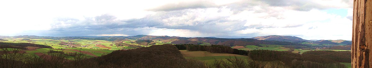
From the 10 - 12 m high structure you have a beautiful view over the Schemmerngrund and that Stölzinger Mountains. In the north is that high Meissner and underneath to see the core town of Waldkappel. At very good view is in the southeast even about 50 km away great Inselberg recognizable in the Thuringian Forest.
Access: The structure and the shelter in the tower are freely accessible. A donation box for a voluntary contribution to the maintenance of the wooden tower can be found at the bottom of the building.


kitchen
Self-catering is the order of the day on the goat stick. But there is enough seating at the tower so that nothing stands in the way of a picnic.
The next gastronomy can be found in Burghofen:
- Gastronomy of the "Hotel zum Stern" - Thüringerstraße 20, 37284 Waldkappel-Burghofen, Tel .: 05656 / 4014-1073, the menu is here on the net (PDF with 0.87 MB)
accommodation
The next guest beds can also be found in Burghofen. Further accommodation options (including a campsite) can be found in the core town of Waldkappel. For details, see the “Accommodation” section in the city article City of Waldkappel.
Individual evidence
Web links
- Site of Burghofen with films about the first tower from 1965 and the second tower from 2008/2009 (to be found under media in the film archive).