| El Paso | ||
 | ||
Coat of arms and flag  | ||
| State | United States of America | |
|---|---|---|
| Federated state | Texas | |
| Altitude | 1140 m a.s.l. | |
| Surface | 249 km² | |
| Inhabitants | 674.433 (2013 estimate), 649.121 (2010 census) | |
| Prefix tel | 1 915 | |
| POSTAL CODE | 79901–79999, 88500–88599 | |
| Time zone | UTC-7 | |
Position
| ||
| Institutional website | ||

El Paso is a city of Texas in United States of America.
To know
El Paso, second only to San Diego between US cities in the border area with Mexico, stands in front of the Mexican city of Ciudad Juárez. The two cities form a trans-national metropolitan area, also called El Paso-Juarez Borderplex of over 3 million people, divided by the Rio Grande River.
40% of the population speaks Spanish and the city is the largest bilingual area in the Western Hemisphere.
Geographical notes
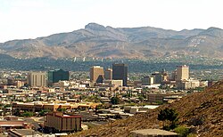
El Paso, surrounded by the Chihuahuan Desert, is located at the intersection of three states (Texas, New Mexico, is Chihuahua) and two nations (USA is Mexico). It is the easternmost part of the Range Region basin. The craggy North Franklin Mountain peaks at 2,192m above sea level, and is the highest peak in the El Paso metropolitan region - the peak can be seen for nearly 100km from all directions.
At 9,700 hectares, Franklin Mountains State Park is the largest urban park in the United States, and is located entirely in El Paso
When to go
| Climate | gen | Feb | mar | apr | mag | down | Jul | needle | set | Oct | nov | dec |
|---|---|---|---|---|---|---|---|---|---|---|---|---|
| Maximum (° C) | 14 | 17 | 21 | 26 | 31 | 36 | 35 | 34 | 31 | 26 | 19 | 14 |
| Minimum (° C) | -1 | 2 | 5 | 9 | 14 | 19 | 21 | 20 | 17 | 10 | 3 | 0 |
| Precipitation (mm) | 10 | 10 | 8 | 5 | 8 | 18 | 41 | 38 | 36 | 18 | 8 | 15 |
El Paso has an arid climate, with very hot summers (with low humidity) and cold winters. The highest temperature record in the city was 46 ° C, and its lowest record was -22 ° C.
The sun shines 302 days a year on average in El Paso, which is why the city is nicknamed "The City of the Sun".
Background
In 1659 the Spaniards founded the settlement of El Paso del Norte, today Ciudad Juárez. The importance of the city, and the reason for its foundation, was given by the fact that for more than two centuries it represented the only land crossing (bridge) over the Rio Grande river to access Texas from Mexico. The area on which El Paso stands today remained uninhabited until around the mid-18th century. The Texan revolution of 1836 did not in the least affect the area, which began to be populated by Mexican and Anglo-Saxon settlers. The 1848 Treaty of Guadalupe-Hidalgo established the definitive separation between the two banks of the Rio Grande. El Paso County was created in 1850 while four years later a military garrison called The Post opposite El Paso. During the American Civil War the Confederates occupied the area but were rejected by the California Column in 1862. At the end of the conflict El Paso began to develop, thanks also to the arrival of important railway lines such as the Southern Pacific and the Atchison, Topeka and Santa Fe. Thousands of new inhabitants arrived in the new city, including priests, businessmen, but also gunmen and prostitutes. El Paso became infamous for its violence and malfeasance, among the main businesses of the city there were in fact prostitution and gambling. With the Mexican Revolution, large numbers of refugees and refugees arrived in the city.
How to orient yourself
The city of El Paso is divided into areas that have their own style and culture:
- Central area (Downtown)
- Eastern zone (East side)
- Western zone (West side)
- Northeast area (Northeast)
How to get
By plane
The city is served by El Paso International Airport, which has 15 gates in 2 terminals. The airport can count on eight companies and 10 fixed destinations.
By car
The city is served, in terms of automotive transportation, by Interstate 10, by the U.S. Route 54 (Patriot Highway), from the U.S. Highway 62, from U.S. Highway 85, from U.S. Highway 180, Spur 601 (Patriot Expressway), Loop 375 (connecting Northeast El Paso to West El Paso via Transmountain Road), Loop 478, various Texas Farm-to-Market Roads, as well as the oldest carriage road in the city, Texas State Route 20. El Paso also shares 5 international bridges (including one rail), with Ciudad Juárez, in Mexico.
On the train
The city is served by the interstate train service, the Amtrak, which, with the Sunset Limited, connects it with New Orleans and Los Angeles three times a week.
By bus
As for the public transport system, the city can count on the Sun Metro Transit System, a bus service throughout the city area. El Paso County has also organized a bus system to the eastern area of El Paso.
How to get around
What see


- Archeology Museum (El Paso Museum of Archeology). It is located on the east side of the Franklin Mountains, in the desert terrain very similar to that of the pre-Colombian societies it portrays. In addition to permanent archaeological finds, the museum offers a series of lectures and exhibitions, nature trails to explore the flora, fauna and geology of the region.
- History Museum (El Paso Museum of History). A permanent collection on the history of El Paso which consists of five galleries representing 400 years of US-Mexican border history. The two galleries on the first floor are dedicated to Mexico, to the first Spanish explorations before the arrival of the Mayflower and to the firefighters of El Paso. The galleries on the second floor house an exhibition space dedicated to individuals and companies who have influenced life in El Paso, a series of ancient artifacts, stories and photos of the neighborhoods
- 1 Art Museum (El Paso Museum of Art). The heritage of the museum combines a strong orientation to the artistic reality of the region with works of international scope; it is made up of five collections, distinguished by both origin and artistic themes.