| New Mexico | |
 | |
Location  | |
Flag | |
| State | United States of America |
|---|---|
| Region | Southwest |
| Capital | Santa Fe |
| Surface | 315,194 km² |
| Inhabitants | 2.085.572 (2014 estimate), 2.059.179 (2010 census) |
| Tourism site | |
| Institutional website | |
New Mexico is a federated state in southwest of United States of America.
To know
Geographical notes
New Mexico is bordered for a short distance to the south by the Mexico, to the east with Texas (103º meridian) e Oklahoma, while to the west it borders theArizona (109º meridian). The 33rd parallel marks the northern boundary line with Colorado. In one place it touches theUtah.
The point where New Mexico, Colorado, Arizona, and Utah converge is called the "Four Corners". The landscape shifts from pink-hued deserts to snow-capped mountains for most of the year.
The landscape of New Mexico ranges from great deserts to high snow-capped peaks. Although in the common imagination it is considered a very arid area, New Mexico is covered by significant extensions of forests, especially to the north. The Rio Grande completely crosses the state from north to south, while Wheeler Peak is the highest peak with its 4,011 meters.
When to go
The climate of New Mexico is generally semi-arid and arid, although there are areas with a continental and alpine climate, and its territory is largely covered by mountains, plateaus and deserts. During the summer months, daytime temperatures can exceed 38 ° C at altitudes below 1500 meters. The state also receives a fair amount of snow, mainly in its higher elevations in the mountains.
Background
In 1540, the conquistador Spanish Francisco Vázquez de Coronado ventured into the territories of present-day New Mexico in search of the fabulous seven golden cities of Cibola. The Spanish colonization in fact began in 1598 with the founding of the centers of San Juan Pueblo and then of Santa Fe in 1605. Other centers founded during the seventeenth century were Albuquerque is Acoma Pueblo. However, much of the region was abandoned by the Europeans due to the vast uprising of the Pueblos Indians of 1680.
The incorporation of the territory of the modern state into the United States of America was partly acquired by France in 1803 as part of the Louisiana purchase, while the portion east of the Rio Grande was claimed by the breakaway republic of Texas at the time of secession from Mexico in 1836; this territory was transferred to the federal government from Texas in 1850. Finally, the southwestern corner of the state (the "spur") was ceded by Mexico in the Gadsden Purchase of 1853 by which the United States of America they bought the territories south of the Gila River for 10 million dollars.
The New Mexico Territory was created on September 9, 1850, united with the Colorado until 1861 andArizona until 1863. The eastern half of the territory became the state of New Mexico, admitted to the Union as a 47th member on January 6, 1912, while the western part was separately admitted as a 48th state with the name of Arizona on February 14, 1912.
The first atomic bomb was detonated in the polygon of Alamogordo, in an area in the desert of Jornada del Muerto on July 16, 1945.
Spoken languages

It is called "the Spanish state", also because it is Spanish is the official language of the state together withEnglish.
Culture and traditions
Among the federation states, New Mexico has the highest percentage of Hispanics, including descendants of Spanish settlers and recent immigrants from Latin America. It also has a sizeable number of Native Americans, and the main tribes of the state are those of the Navajo, Pueblo and Apache peoples. The result is that the demographics and culture of the state are unique to the strong Hispanic and Native American influences both of which are reflected in the state flag. The red and gold colors of the New Mexico flag are taken from the flag of the Spain, along with the ancient sun symbol of the Zia, a tribe of the Puebloan community.
Suggested readings
- Tony Hillerman. The Great Taos Bank Robbery and other Indian Country Affairs. Albuquerque, University of New Mexico Press, 1973. ISBN 0-8263-0530-X.
- Paul Horgan. Great River, The Rio Grande in North American History. Holt, Rinehart and Winston, 1977. ISBN 0-03-029305-7.
- Ralph Emerson Twitchell, The Leading Facts of New Mexican History Vol. 1 and 2, Sunstone Press, 2007, ISBN 0-86534-565-1.
- (FR) Samuel Gance, Anton ou la trajectoire d'un père, The fictional story of his father Anton Docher. L'Harmattan, Paris, 2013, 208 p. (ISBN 978-2-336-29016-4)
Territories and tourist destinations

Urban centers
- Santa Fe - Capital of the State of New Mexico and its primary tourist attraction, with historic architecture, scenic beauty and a concentration of art and culture.
- Alamogordo - A large city notable for its museum on the history of space and its proximity to the White Sands National Monument.
- Albuquerque - By far the largest city in the state and its center for commerce, with a good number of tourist attractions, including a huge and spectacular hot air balloon party.
- Farmington - The largest city in the northwestern part of the state, and an access point for the Navajo Reservation and the point of the quadruple boundary.
- Las Cruces - The second largest city in the state and the largest in the southern part of the state.
- Las Vegas - A beautiful town full of history and the largest city in the northeastern part of the state.
- Roswell - A medium-sized city known for the alleged crash of a flying saucer near it in 1947.
- Silver City - An old mining town located in the southwestern part of the state.
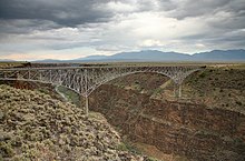
- Taos - In the southern Rocky Mountains, Taos is among the most popular destinations due to the incredible scenic beauty, world famous ski resorts, architecture, art scene and food.
Other destinations
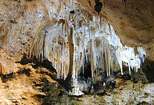
Areas of geographic and scenic interest in New Mexico include:
How to get
By car
Some of the interstate highways to reach New Mexico are:
- Interstate 10
- Interstate 25
- Interstate 40
How to get around
What see
What to do
At the table
Safety
Other projects
 Wikipedia contains an entry concerning New Mexico
 Commons contains images or other files on New Mexico