
The Friendship Highway in Tibet leads from Lhasa above Xigazê to Zhangmu on the border to Nepal.
background
The Friendship Highway or China-Nepal Highway (Zhong-Ni gonglu) connects Lhasa in Tibet with Kathmandu in Nepal. The border station is at the Friendship Bridge between Zhangmu in Tibet and Kodari in Bagmati Province in Nepal. The highway is part of the Chinese road G318who is in Shanghai starts after 4,760 km Lhasa reached and in Zhangmu ends after a total of 5,476 km. On the Nepalese side, the street continues under the name Arniko Highway away.
Construction of the road began in 1958 and was opened to traffic as early as 1965, at that time mainly as a gravel road. At the moment (May 2010) only a few kilometers are still under construction near Zhangmu, and final completion can be expected later this year.
The highway is a consistently at least two-lane road with moderate uphill and downhill sections, it crosses several passes with a height of 5,000 m. You can expect carts pulled by yaks, donkeys and tractors on the roads, and there are sometimes (European) cyclists on the road.
preparation
The scenic route can be driven in both directions, for the sake of simplicity, Lhasa is assumed here as the starting point and the Nepalese border as the end.
getting there
- Lhasa: When entering with the Lhasa Railway, on the Qinghai-Tibet Highway or the Sichuan-Tibet Highway, i.e. via China, first a visa for China is necessary, then an entry permit for Tibet, the Tibet Entry Permit and finally that Alien Travel Permitwithout getting through the controls along the way.
- From Nepal: You need a group visa, available at the Chinese embassy in Kathmandu. As a rule, travel agencies do this in connection with a booking. Details also at Windhorsetours, see web links.

Entry via the Friendship Bridge Between Nepal and Tibet there is a special kind of border clearance. You are only allowed to cross this bridge on foot and you have to watch how you get to about 10 km away Zhangmu got. As a rule, porters are available to take the luggage from the Nepalese side to customs for a few dollars, pick it up again after clearing and transport it to a vehicle (minibus). Meticulous controls are the norm at the Zhangmu border station. For example, no picture of the Dalai Lama may be introduced; similar pictures can already cause trouble, e.g. pictures of Buddhist monks in printed travel guides. Discussions with the customs officers are pointless.
Drive / let's go / ...

Lhasa - Xigazê
There are two ways to travel towards Xigazê from Lhasa. In terms of traffic, it is simple Route 1that follow the course of the road G318 holds. The one running south Route 2 is the old, more scenic route that most Tibetan pilgrims also prefer.
Route 1: Lhasa - Quxu - Xigazê
From Lhasa you drive on the main road, the Beijing Road going west along the Lhasa river (Kyi Chu). It's on the outskirts Drepung Monastery like a small town on the mountainside. Not far from there is a checkpoint where the residence permit is checked. At Doilungdeqn the river turns south. Shortly before Quxu (Qüxü) a road branches off to the east, it leads to the airport Lhasa Gongga. In Quxu the Lhasa River flows into the Yarlung Zangbo, the upper reaches of the Brahmaputra. The street G318 leads past upstream Wrinkling to Xigazê
Route 2: Lhasa - Yamdrok Lake - Gyantse - Xigazê

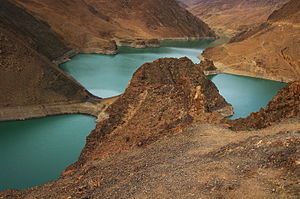
The route is initially identical to Quxu, there she turns south and crosses the Yarlung Zangbo. It then goes up in numerous bends to the pass height of 4,794 m Khampa La. From there you have a magnificent view of the turquoise-blue Yamdrok Lake and the snow-capped mountains. Colorfully decorated yaks are ready for a little ride. The road leads down into the valley along the shore of the lake, at Nagarzê she goes west.
It goes uphill to the 5,030 m high Kharu La (Karo La) Pass, it is towered over by the snowfields of the glacier. Various types of minerals are offered for sale here. Again it goes into the valley, then comes the top of the pass Sim Lawhich is modest at 4,330 m, but it offers a good view of a reservoir with the remains of an English fort. A few kilometers further you finally reach Gyangzê. The monastery is particularly worth seeing here Pälkhor Chödebut also the view from the top of the Dzong.
Through the green valley of the Nyang Chu the journey continues, past the Pharla Estate. Here it is shown, decreed by the state, how the Tibetans suffered under serfdom, especially the monasteries. You can also get an idea of rural life for yourself. Right next to the river there are still water-powered mills in which the barley is made Tsampa processed, and some farmers are also ready to show their homes. Shortly before Xigazê, a side street leads to Shalu Monasterywhich is famous for its murals.
Xigazê - Lhatse

The on Yarlung Zangbo located district capital Xigazê offers a predominantly Chinese cityscape, but there are also very good shopping opportunities. The externally well restored Dzong has not yet been released for viewing, the market below in the Tibetan old town is worth seeing. The blue domes of a mosque reveal that not only Buddhist Tibetans live here. An absolute one Got to is the monastery Tashilhunpo, the traditional seat of Penchen Lama. The road now runs a little south of the Yarlung Zangbo over land, on it one comes to the 4,500 m high and adorned with countless prayer flags Tsuo La. A detour leads back to the plateau Sa'gya and the monastery complex there. You can get back on the main road after a few kilometers Lhazê.
Lhazê - Zhangmu

The city of Lhazê is divided into two parts, with both the main street and the main street running between the old and the new town Yarlung Zangbo, along the river runs a gravel road to the Phuntsoling monastery. The Friendship Highway now leaves the valley of the Yarlung Zangbo, he goes through a plateau that always offers a beautiful view of the Himalayan mountain range. At New Tingri or Shegar one comes into a mandatory police check for Tibet. Not far from there is a branch into the national park Qomolangma and to the base camp of Mt. Everest. The beautiful view remains even until the old one Tingri receive. Then you reach the 5,050 m high Lalung La, it's the highest pass on this highway. Now it goes in the direction Nepal. Of Milarepa's cave above the county seat Nyalam if you have the snow-covered mountain range in view again, a control station follows, then you finally come down to the border town Zhangmu and to the border station.
security
trips
At Lhazê the road branches off G219 from, also as Xinjiang-Tibet Highway known. This highway leads over saga past the Mt. Kailash and the Lake Manasarovar and finally to the provinces Xinjiang.
literature
Web links
- Windhorseteours, Entry into Tibet
.svg/90px-Tibet_(Chinese_and_Tibetan).svg.png)