| Gouhenans | |
 | |
| Saint-Etienne church and town hall | |
| Information | |
| Country | |
|---|---|
| Area | 8,45 km² |
| Population | 381 hab. () |
| Density | 45,09 inhab./km² |
| Postal code | 70110 |
| Spindle | UTC 01:00, UTC 02:00 |
| Location | |
 47 ° 36 ′ 25 ″ N 6 ° 28 ′ 10 ″ E | |
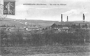
Gouhenans is a village and municipality of Haute-Saone. The village is divided into two distinct areas. To the west the old castle town dominated by the castle and the church steeple. To the east, the old industrial district of the saltworks dominated by a square red brick chimney.
Understand
visitor Center
- 1 Pays de Villersexel tourist office ,
 33 3 84 205959
Story
The first documents on Gouhenans were found at the abbey of Bitaine and date from 1186. The castle, located on the edge of the cliff which dominates the village, was preceded by a fortified house dating from 1472. The oldest parts of the current castle date from the XVe century. From the building, to this day incomplete, one can admire the turret, the entrance door and the vaulted cellars.
The castle of Gouhenans already existed in the 14the century. According to Louis Gollut, it was a good fortified house in the county of Burgundy and many old houses remain, as well as some rare pieces in the Saint-Étienne church, dating from the 17th century.
Coal was discovered in Gouhenans in the 1770s, but semi-industrial exploitation would really take place between 1828 and 1899 and then again between 1906 and 1916. It was by exploiting coal that salt was discovered. Its exploitation by water injection will be done until the end of the Second World War. The presence of coal on site for the evaporation of the brine allows the company to lower the cost of salt. A chemical plant and a glass factory were added to this industrial complex which marked a period of prosperity for Gouhenans. The chemical activity became the property of the Kuhlmann group in 1927 and remained until it closed in 1955.
The saline.

The coal pit
n ° 13.


To go
Circulate
To see
Castle town
- 1 The castle – .
- 2 Saint-Etienne church – .
- 3 The war memorial – surmounted by a rooster and framed by two artillery guns.

The castle.

The church.

The war memorial.


Industrial and mining heritage
- 4 The old saltworks and factories – .
- 5 The working city of glassmakers – .
Do
- 1 The way of salt and coal – allows you to visit the village of Villafans, the old charcoal mines of Viallafans, the saline district then the castral bourgeoisie of Gouhenans and finally the village of Longevelle with its old ruined bell tower and its seigneurial chapel.
- 2 Well n ° 15 – (confused with n ° 11 on the explanatory panel).
- 3 Ruined stately chapel and bell tower – renovated by the Society of History and Archeology of the Arrondissement of Lure (SHAARL).

Remains of the ruins of the saltworks.

The old well n ° 15 developed.

Longevelle stately chapel and ruined bell tower.


