 | ||
| Kilimanjaro | ||
| province | Arusha | |
|---|---|---|
| height | 5,895 m | |
| Tourist info web | tanzaniaparks.com | |
| no tourist info on Wikidata: | ||
| location | ||
| ||
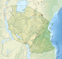
The Kilimanjaro is a mountain range in Tanzania on the border to Kenya. The highest peak is called "Uhuru Peak" and is also the highest point in Africa. The 1973 founded Kilimanjaro National Park has been part of the UNESCO World Heritage Site.
places

background
The origin of the name is not clear, in general "kilima njaro" is interpreted as "white shining mountain" or "snow mountain", but in Kiswahili Kilimanjaro means "mountain of the evil spirit". Kibo means "the light one" and Mawenzi means "the dark one".
The "Roof of Africa" has the dimensions of approx. 50 x 80 km in plan. The highest point on Kilimanjaro is the "Uhuru Peak" with 5,895 m, the massif as a whole is not only the highest mountain in Africa, but also the highest free-standing mountain in the world, because it towers over the surrounding savannah landscape (1000 m) by approx. 4,900 m. The three peaks are the Kibo with the highest elevation Uhuru Peak (5,895 m), the Mawenzi (5,148 m) and the Shira (3,962 m).

The multiple volcano Kilimanjaro owes its formation to the Eastern Rift, the eastern branch of the Central African Rift, a volcanic fault zone of the continental plate tectonics.
Of the three volcanic peaks, the Shira is the oldest, it has been inactive for around 500,000 years, the last major eruption at the main peak took place around 360,000 years ago. Various recent theories assume that the volcano is currently only in a long dormant phase. Evidence suggests a smaller eruption 5000 years ago, in the traditions of the Chagga there are references to fire over the Kibo about 200-400 years ago.
The main summit Kibo has an outer caldera (volcanic crater) with a diameter of around two kilometers at a depth of 200 m and with the actual volcanic cone and the inner caldera with a diameter of 800 m, from which sulfur gases (fulmar oils) and water vapor escape.
history
The first reports that became known in Europe come from the missionary Rebmann from 1846 about a glaciated mountain in Africa near the equator, which, however, was not believed. In 1862, however, Claus von Betten and Otto Kersten reached an altitude of 4,316 m and confirmed the white color of the summit as ice, and not as the presumed salt.
The first ascent succeeded on October 6, 1889, after several unsuccessful attempts by the German professor Hans Meyer (publisher of the dictionary) together with the important Austrian mountain guide Ludwig Purtscheller. Meyer named the highest point on the crater rim in honor of the German emperor as "Kaiser Wilhelm Spitze", since the mainland was part of the German Empire at the time as a colony of German East Africa. The summit is the highest point on a wide plateau on the crater rim of the outer caldera.
The name given may also have been the reason that Queen Victoria of England (at that time the most important woman in the world), in the course of establishing the zones of influence between the former British colony of Kenya and German East Africa, gave the whole mountain to her grandson, the German Emperor Wilhelm II . (at that time the most powerful man in the world) gave: The kink of the border on Kilimanjaro in the otherwise completely straight border between Kenya and Tanzania is still clearly visible on every globe today.
The first survey attempts helped the "highest German summit" in the old maps with a little good will over the important 6000 mark (values up to 6014m), with GPS the height of the Kibo is now established with 5,895 m.
In 1964, the first President Julius Nyerere of Tanzania, which has been independent since 1961, had the summit of Kibo renamed "Uhuru-Peak" (Freedom Summit).
Kilimanjaro National Park
The area around Kilimanjaro was declared a national park in 1973. It covers the regions above 1,800 m and has an area of approx. 750 km². The national park has been part of the UNESCO World Heritage Site.
Uniqueness is necessary for the award of the title "World Natural Heritage". The organization cites as a reason, among other things, the superlatives of the giant volcano as the highest free-standing mountain in the world with its five different ones Climates and the biodiversity of the flora and fauna.
- Side of the UNESCO to the national park.
tourism
Klimanjaro has around 20,000 visitors a year, with up to 500 tourists on peak days, plus 1,500 porters and mountain guides daily during the high season. With the further expansion of the infrastructure, the trend is increasing.
The income from tourism is the most important external source of money for the people on Kilimanjaro. The daily wage for porters and guides of the equivalent of around 10 euros to 13 euros (excluding tips) is comparatively high, but the strain on the porters is considerable: the official upper limit for the porters' loads is twenty kilos, but there are also personal ones Objects. On the way, the porters with mostly inadequate equipment such as sandals and thin pants or sweaters are in the cold environment above. The problems with adapting to altitude in the thin air are no different for the locals than others, although training allows them to adapt to the thin air better. The result is that the mostly young porters often have to give up their business after around five years due to health problems.
An article in daily mirror
Today the mountain is of interest not only to mountaineers but also to climate researchers: the dramatic decline of the last glaciers on the crater rim is a clear indication of global warming. Tanzanian and American researchers attribute the melting of the glaciers to an interaction. In the last few decades, more and more agricultural land has been gained through raw manure, even at higher elevations on Kilimanjaro. This reduces the humidity. On the one hand, there is less precipitation, on the other hand, the protective cloud cover over the massif tears more and more often.
language
The official languages in Tanzania are Kiswahili and English, although English is only spoken well by educated people. In addition to these two languages, the Wachagga who live on the slopes of Kilimanjaro speak their own Bantu language, the Kichagga. Almost all guides are fluent in English and many porters can also speak English.
getting there
By plane
The Kilimanjaro International Airport is the nearest major airport with regular scheduled flights. It is the option for all air travelers to Kilimanjaro. Condor flies once a week from Frankfurt and KLM flies several times a week from Amsterdam. There are still a number of good connections in the region from Kilimanjaro Airport, especially with Precision Air (Nairobi, Dar es Salaam, Mombasa, Zanzibar, Mwanza) and Air Tanzania (Dar es Salaam, Zanzibar). In addition to KLM, other international airlines such as Ethiopian Airlines and Turkish Airlines are also at the airport. Ethiopian Airlines offers a connection to Addis Ababa in Ethiopia twice a day.
mobility
Tourist Attractions
The sophisticated one Irrigation system the chagga in the climate zone of the rainforest is several hundred years old and consists of numerous artificial water channels. These hydraulic structures have long been underestimated in their importance and are now considered evidence of a high culture. The agriculture of the smallholders on Kilimanjaro is one of the most effective in all of Tanzania. The best examples can be found at Marangu. The existence of the cultural area and the unique ecosystem is threatened with the retreat of the glaciers and with the smaller amounts of water from the precipitation and in the natural watercourses.
Wandering rocks are an effect in the that has not yet been definitively explained High altitude desert with strong sunlight and large temperature differences between day and night: individual boulders weighing several hundred pounds move on completely flat terrain on the sand of the volcanic ash as if by magic and leave a clearly visible trail behind them. The phenomenon is also from other desert regions [1] known. An effect of ice formation during the night as a result of moisture from fog is assumed.
flora
The most striking effect in the flora of Kilimanjaro is that Huge growth in the afro-alpine climate level over approx. 2,800 meters: under the special climatic conditions and under the influence of UV rays, lobelia and senecia, actually low-growing flowers and herbs, reach heights of growth of several meters.
The Mountain rainforest is impenetrable off the beaten track and is characterized by its diversity of plants: epiphytes such as tree ferns and orchids and lichen beards that hang down up to a meter in length grow on old rainforest giants.
fauna
In the mountain rainforest, the screams of the half-apes (diademed monkeys, coat monkeys and guerezas) are unmistakable, and you can occasionally see them. The most noticeable voices of the bird world are above all the common "singing concerts" of the silk turakos in the evening.
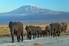
Large animals are seldom seen, there are bushbucks, the story is told of the elephants who get lost high up at an altitude of 4,000 meters. The leopard is also mentioned: the animals are very shy and notice people before they see them.
activities
The ascent

On the normal routes, Kilimanjaro is a pure hiking mountain with no technical or alpine requirements. Only parts of the summit stage that may have iced over during the rainy season can force you to walk carefully. In contrast is the absolute height of the summit, which means that only a fraction of the candidates achieve the goal.
The most important requirement is one Top constitutionHaving a cold already dramatically reduces the chances of success.
A good condition is of course very helpful, but many well-trained athletes without any altitude experience fail because they are more willing to exert themselves on the consistently easy stretches, which then often results in a complete physical breakdown with removal and often a longer period afterwards Hospitalization has the consequence. In addition, large muscle masses require significantly more oxygen than other types of tissue, which can also be a disadvantage.
The Altitude sickness usually does not come by the wayside, but rather during the recovery phase of the body at night. The rule of thumb is that those who extend the specified running times of the individual daily stages (approx. 4 to 7 hours) by another 1 to 2 hours or more significantly increase the chances of success for the summit. The serious mountain hiker should approach the tour calmly in order to be able to start the decisive summit stage with a "full battery": "pole pole" (slowly slowly) that's why the experienced guides say again and again.
More detailed Notes on height adjustment is also available in the article on the topic Rockclimbing;
dress: In general, the requirements for a "late summer hike" in the high mountains:
- Good, well-worn hiking boots are a must.
- In the lower regions it is more "shirt-sleeved" during the day: you hike in a T-shirt. At the latest, the summit stage will take place at temperatures of around -7 ° C or below: Winter equipment must be available, and the day's stage beforehand is usually quite drafty: "xxx-tex" as a windbreak.
- Depending on the season rainfalls must also be planned for.

costs: Depending on the length of stay, the national park fees for approx. 6 days are around 500 euros per person. In addition, the porter costs (US $ 10 per day), the costs for the guide (compulsory, approx. US $ 25 per day) and the costs for food and transport to and from the accommodation must be taken into account. Overall, a six-day ascent of Kilimanjaro from the National Park gate can be expected to be a good 1000 euros per person. As a tip for the guide and porter, you should calculate about 5-10 euros per person and per day of stay, and only this money ends up completely with the working team (as of 2012). If you want, you can do without porters and carry all your luggage yourself, but you save little money, deprive a local of an income opportunity and thus significantly reduce your chances of reaching the summit.
Various agencies take over the organization of the team on site and thus also guarantee a certain experience of guides and porters.
The relevant German and European tour operators have the ascent in different variants and as an "all-inclusive" package in their program. Locally, especially in Moshi and Arusha, you can also book good and safe packages. However, there are also known cases in which the carrier team made considerable additional demands after the first day.
There is a visa requirement for Tanzania.
Organizer on site:
Marangu route
Also jokingly referred to as the "Coca-Cola Route" because you can buy Coca-Cola at all huts, it is the easiest ascent and therefore also the safest way to reach the summit. The total length of the route (there and back) is approx. 68 km, the actual running times per day's stage are only four to six hours. However, it makes no sense to be in a hurry: there are no special entertainment options at the huts and walking slowly also promotes altitude adjustment!
As a rule, the tour is completed on six days with three ascent stages to the huts, an acclimatization day, the crucial day of the summit stage and a descent day.
The hut buildings were built in the second half of the last century on the initiative of the Norwegians. There is a simple infrastructure: drinks (including beer) and small snacks can be bought at the huts.
- Marangu Gate (1,840 m, 3 ° 14 ′ 36 ″ S37 ° 31 '3 "E) Park entrance, start of the first stage through the mountain rainforest.
- Mandara hat (2,675 m, 3 ° 10 ′ 53 ″ S37 ° 30 '49 "E.), near the huts there is the small Maundi crater;
- Horombo hat (3,725 m, 3 ° 8 ′ 20 ″ S37 ° 26 ′ 21 ″ E), usually a day of rest is inserted here to adjust the altitude, which significantly increases the chances of the summit. An acclimatization tour to the foot of Mawenzi is possible from here. The summit of Mawenzi is not for mountain hikers because of the technical difficulties (climbing mountain) and the fragile rocks. In addition, ascent is generally prohibited by the park administration.

- Kibo hat (4,700 m, 3 ° 4 ′ 54 ″ S37 ° 23 '21 "E), last station before the summit stage, the ascent to the hut leads rather monotonously and over 11 kilometers through the almost vegetation-free high-altitude desert. The hut is a cold stone building with a dormitory, sleep is "in short supply". The start to the summit is then in the middle of the night (headlamp). The summit stage with just under four kilometers is an arduous "hatscher": around four to six hours it goes uphill on volcanic gravel as if on a steep pile of gravel according to the motto "two steps forward, one slipped again" to the crater rim of the outer caldera:
- Gilman's Point (5,715 m, 3 ° 4 ′ 28 ″ S37 ° 22 ′ 6 ″ E) at the edge of the crater, those who have made it to this point will receive the green-framed "certificate of ascent" from the guides as proof of success at the exit of the park. If the ascent rate is planned, you can experience the sunrise here.
- Those who are still fit enough at Gilmans Point can still do the last two kilometers (a good hour) to the highest point on the mountain, the Uhuru Peak (5,895 m, 3 ° 4 ′ 33 ″ S37 ° 21 '12 "E) march on, this part of the route is much flatter than the ascent to the crater rim, but several counter-climbs at this altitude are very exhausting. Upon reaching Uhuru Peak, you will receive the gold-rimmed summit certificate.
Usually, the summit descent to the Kibo hut and the onward march to the Horombo Hut take place on the same day, the last day is the descent to the park exit.
Machame route
This route is more sporty than the Maranga route, offers acclimatization during the tour due to the ascent around the south side of Kili at around 4,000 m and is also called the whiskey route.
The route is a pure tent route. The tents are set up by the local agency and transported from camp to camp by their porters and are set up and dismantled daily. Bringing your own tents is allowed - but then you have to set up and dismantle the tents that Porters can also transport yourself on a daily basis.
On the first day, this route leads from the Machame Gate, which is approached by mini-bus or all-terrain bus, at 1,800 m in officially 5-7 hours over 18 km in the rainforest on damp to muddy paths to Machame Hut at 3,000 m. On this day, many have Climbers wear way too much clothing because they think of the 3,000 m altitude of the day's destination and combine this with knowledge from the Alps - the day tour is humid and warm, which is why shorts and T-shirts are usually sufficient as outerwear.
On the second day, it goes from Machame Hut in 4-7 hours over 9 km in heather and grassland with firm to rocky ground to Shira Camp at 3,840 m. Long pants and anorak are required. On this day, some climbers experience problems with altitude sickness, as they are often not acclimatized immediately before their departure to Kili through tours in the Alps over 3,000 m with sleeping places over 2,500 m.
The third day will be even more strenuous than before, as the route from Shira Camp at 3,840 m until the lunch break is constantly uphill between pure black lava stones in a strong and cold wind, initially to the Lava Tower junction at 4,600 m. Strong sunglasses, gloves, headgear and sun blockers on the face, ears and nose are required. At the Lava Tower junction, problems of altitude acclimatization in the form of the addition of altitude sickness with shortness of breath, rattling cough, unsteady gait, facial pains and vomiting become very clear with several climbers. At the Lava Tower junction, you can take the short detour to the left almost at the same height as the Lava Tower or you can take the direct steep descent first to a plateau at 4,300 m and then further down to Barranco Camp at 3,960 m. During the descent, numerous Senecia (cruciferous plants up to 5 m high) brighten the eye and the mind.
On the fourth day, the tour is "only" recommended from the Barranco Camp at 3,960 m over 3-6 h for 7.5 km of rocky desert to the Karanga Camp at 3,930-4,005 m. Immediately after the morning start, the Breakfast Wall awaits you with an altitude difference of around 180 m from the camp - here it goes up in steep serpentines for 1.5 hours. Then wavy up and down until the deep cut of the Karanga Valley is reached, where you have to descend steeply (Reep cord recommended as a safety device) and up again steeply until you reach the Karanga Valley at the edge of the valley. When the weather is good, the Shira peaks and Mount Meru with the Socialist Peak can be seen from Karanga Camp. Attention: If you want to go on a further 3-6 hours on the fourth day, and thus a total of 6-12 hours depending on the weather, to the Barafu Camp at 4,600 m, in order to save a day's travel time and about $ 250 travel costs, you risk unnecessarily failure the ascent, because it will be too strenuous for most and the longed-for summit success on Uhuru Peak does not materialize.
The fifth day makes sense only from Karanga Camp at 4,005 m over 3-6 hours for 6.5 km of rocky desert, partly in snow and ice, to the regularly icy Barafu Camp at 4,600 m, where the Mawenzi shimmers with its wild peaks at 5,148 m across from.
On the sixth day, the summit storm is announced for those who have made it this far. The wake-up time is 11 p.m., the start time on the summit is then midnight. First, after about 5-6 hours of extremely strenuous ascent, Stella Point is reached at 5,745 m. As the rim of the crater, it counts as a summit success and you then receive the summit certificate with a green border at the bottom. In a leisurely incline along the edge of the crater, you pass the Rebmann Glacier and Kersten Glacier. A final short clear climb then leads over the Hans Meyer Point at 5,888 m and a penitent ice rink on the Uhuru Peak with its 5,895 m. This summit day tour is estimated at 12.5-15 hrs pure (!) Walking time, summit break on 5,895 m with 0.25 h as well as a break downhill in the Barafu Camp at 4,600 m with 0.75-2 h and in the Millenium Camp at 3,900 m with 0.25-0.5 h must be added at least. About 7 km ascent and 23 km descent. At the end of July, sunrise is at around 6:30 a.m. on the summit. At the end of July, Uhuru Peak has temperatures as low as - 26 ° C and the strongest winds. Head mask, neck protection, warm mountain boots, spare gloves, thermos for drinks and multiple cold protection for the camera are also necessary. For most of the climbers, this day is likely to be the hardest day of their lives so far - not only endurance, but tenacity and perseverance are necessary with (!) Sufficient altitude acclimatization. Most climbers fail that day at some point during the night somewhere in the sliding, steep scree slope and have to turn back in time or be dragged down by assistant guides and guides because they physically collapse. There is no helicopter rescue here. "Move down" here means on the back of an assistant guide or guide or a stretcher if there are still two assistant guides or guides from your own group - in the worst case in a stretcher. If a group of 8 climbers usually has one guide and two assistant guides, the first assistant guide descends with the first tourist who can no longer. If the second tourist in the group cannot go on, the second assistant guide goes downstairs with them. If one of the six remaining tourists has another problem, then all six have to descend with the one remaining guide. Shovel on it, luck on it. Farewell to the summit. The descent from Barafu Camp is again strenuous because of the length of the path and numerous meter-high breaks in the path. In the Mweka Camp at 3,100 m, beer can be purchased for the first time on this tour - it tastes good as a summit beer even if the small bottle 3 , - $ costs.
On the seventh day, the path leads from Mweka Camp at 3,100 m in 3-4 hours for 15 km through damp and muddy rainforest with black and white flying monkeys in the treetops to Mweka Gate at 1,800 m with registration there, receipt of summit certificates or not and on to the village of Mweka at 1,700 m. Depending on the organizer and the vehicle used, as well as the daring driver, pick-up by car at the Mweka Gate or in the village of Mweka to drive past three-storey fields (potatoes below, coffee in the middle, above Bananas) and pure coffee plantations to the hotel in Moshi with a stop on the way at a souvenir shop for Kili T-shirts and Kili Bush hats.
Mweke route
Shira route
Breach Wall (Western Breach)
The route through the Breschenwand was first climbed by Reinhold Messner. Although this route is generally shorter than all other routes and also on the summit day over the Arrow Glacier and Western Breach, it has been closed by the national park administration since 2004 after two Americans fatally fell at the climbing points of the actually manageable low level of difficulty III.
kitchen
accommodation
All ascent routes are linked to overnight stays in tents for two to four men and extra kitchen tents, with the exception of the Marangu route, on which people only sleep in huts.
security
In the places at the foot of the mountain there are no major problems for foreign tourists in groups. On the mountain itself and in the surrounding wildlife national parks, the rangers are at the gates with Chinese Kalashnikov assault rifles and old British repeating rifles as protection from wildlife Animals and equipped against poachers. However, there have been no large game such as elephants and leopards on Kili on the normal routes for decades. During the acclimatization tour on Mount Meru, the group is regularly accompanied by armed rangers, as there is a risk of big game here.
climate

There are two dry seasons and two rainy seasons on Kilimanjaro. The dry seasons are the weeks from December to mid-March and from early June to mid-September and are generally the most popular months to visit. When climbing in July or August, the safest way to acclimatise to altitude is in the Alps immediately before the tour on Kili with high-altitude tours well over 3,000 m and sleeping places over 2,500 m. The month of January is best suited in the African midsummer. B. should insert at Mount Meru nearby.
The small rainy season begins in October and ends in December, but rainfall is mostly limited to the afternoon. One reason for visiting in the short rainy season is that the routes are not so overcrowded, there is occasional sunshine with impressive cloud formations and a mountain rainforest without rain is only half an experience. In addition, only the region below around 4000 m is affected by clouds and precipitation.
The main rainy season is from mid-March to the end of June with a large part of the rainfall, these months are not recommended for a visit. Here, the average amount of water falls in a month, as in Hanover in a year.
The precipitation on the mountain is strongly dependent on the altitude, at an altitude of 1,800 m, about 2300 mm of precipitation falls annually, the summit region is a desert region with only 100 mm of precipitation per year.
The temperature is warmest in January, while it can get significantly colder in August and September (just under 10 ° C temperature difference). In the savannah, an average temperature of 30 ° C applies, the annual mean at the summit of Kibo is only around 0 ° C, temperatures down to -26 ° C and with the strongest winds are possible at night and early in the morning when the summit is reached.
Climates
The five different climatic zones on the mountain are:
- The so-called begins at approx. 1,000 m above the dry savannah in the surrounding area Coffee banana forest, a cultivated forest used intensively for agriculture by smallholders. The region gets its water via a sophisticated canal system (see under the Tourist Attractions) from the humid region of the rainforest above.
- The Mountain rainforest starts at 1,700 m and extends to approx. 2,800 m above the tree line, this is where most of the precipitation falls, the area has been a game reserve since 1921.
- The afro-alpine level begins at 2,800 m as a grassland, heather bush and steppe region, its upper end is around 4,000 m. The characteristic of the region is that Huge growth of senesia and lobelia, actually low flowers, several meters high.

- The High altitude desert are the areas over 4,000 m and characterized by extreme temperature fluctuations between day and night. With the low rainfall, only around fifty species of plants can be found here.
- The level As the uppermost climatic region on Klimandjaro, it starts at 4600 to 4700 meters and is the snow and glacier region that receives less precipitation than snow. Above 4900 meters, the only plant that grows is a crusty lichen and only grows by one millimeter per year, but it can live for several hundred years.
health
There are hospitals and medical centers according to European standards in Arusha and Moshi. Small hospital wards in every larger village at lower altitudes, such as in Marangu or Himo.
The big health issue is that malaria, it is transmitted by nocturnal Anopheles mosquitoes. Here prophylaxis (prevention) by taking medication before, during and after the tour is recommended. With regard to the remedy Lariam, reports of pronounced side effects at high altitude are known.
In the lower regions of the mountain there are poisonous animals like snakes, spiders and scorpions and also poisonous millipedes or caterpillars. One should therefore not reach into crevices or holes in the ground. Sleeping bags, bed linen, clothes and shoes should be visually inspected and shaken out before each (!) Use, like every (!) Morning and every (!) Evening, and the shoes should be washed out with a spoon or knife. Before sitting on a tree or stone, one should examine it. Nevertheless, poisonous animals pose the lowest risk.
The greatest risk of an ascent is not a lack of fitness, but a lack of altitude adjustment immediately before the tour on the Kili. That is why the success rate for the summit fluctuates significantly between 20–33% (British figures), 50–60% (local Tanzanian agencies) and 80–100% (German and Austrian mountain tour operators) depending on the season, weather and preparation of the participants. The success rate regularly refers to the crater rim with Gilmans Point or Stella Point depending on the route, i.e. not to Uhuru Peak. However, there is also information that the 20% success rate for Gilmans Point only applies to those who have even made it to Kibo Camp at 4,700 m as the starting point for the summit storm. Younger people seem to be more likely to be at risk of altitude sickness because sie in Höhenlagen bis etwa 3.500 m ihre sportgestählte Kondition zeigen wollen und deshalb viel (!) zu schnell aufsteigen, zumal in den unteren Höhenlagen der einfache Wegverlauf zum schnellen Schreiten verleitet.Prospektangaben deutscher Bergführerbüros wie „technisch unschwer, Kondition erforderlich, Tagesetappen 4 bis 6 Stunden, am Gipfeltag etwas mehr“ sind wegen Weglassung der auch lebensbedrohlich werden könnenden Höhenprobleme verharmlosend und verleiten Wanderer zur Tour-Buchung, die mit der gewaltigen Höhe von 5.895 m nicht ansatzweise klarkommen.Notwendig sind innerhalb von 14 Tagen vor Abreise an den Kili eigene mehrtägige Höhentouren mit Schlafstellen oberhalb 2.500 m und mehreren Tagestou ren deutlich über 3.000 m, besser über 3.500 m z. B. auf der Oetztaler Runde in Tirol mit allen Gipfeln wie Wildspitze und Similaun oder in den Walliser Alpen um Saas Fee mit den dortigen leichten Viertausendern wie Breithorn, Allalin und Weißmies.Als Mindestalter werden teilweise 16 Jahre, jedoch vorwiegend 18 Jahre empfohlen.
Siehe außerdem auch die allgemeinen Ausführungen zum Thema Gesundheit im Artikel zu Tansania.
Practical advice
Handyempfang vor Ort ist fast überall möglich, in Gipfelnähe gibt es seit 2001 einen Mobilfunkmast der Mobiltelefongesellschaft Safaricom, er war seinerzeit der höchstgelegene Telekommunikations-Mast der Erde. Lediglich in den Höhenmetern 5.000 bis 5.400 m gibt es am Osthang des Kibos ein Funkloch. Allerdings haben deutsche Netzanbieter kein oder kaum Roaming-Abkommen mit dem einheimischen Netzanbieter - wer vom Gipfel Grüße senden will, sollte ein Satellitentelefon mitführen und vor Kälte geschützt halten.
literature
- : Kilimandscharo: Die deutsche Geschichte eines afrikanischen Berges. Klaus Wagenbach, 2011, ISBN 978-3803136343 ; 192 Seiten. 22.90 €.
- ; Heinrich Pleticha (Hrsg.): Die Erstbesteigung des Kilimandscharo 1889. Edition Erdmann, 2001, ISBN 978-3865031464 , S. 318. 24.- €. Reiseberichts des Erstbesteigers.
- : Schnee auf dem Kilimandscharo: 6 Stories. rororo, 1999, ISBN 978-3499226045 , S. 128. 7.99 €. Die Kurzgeschichtensammlung des Nobelpreisträgers für Literatur enthält auch seine vielleicht bekannteste: In einfachen Worten werden die letzten Tage und das Sterben des Schriftsteller Harry in der ostafrikanischen Wildnis erzählt. Die Kurzgeschichte wurde 1952 mit Gregory Peck, Susan Hayward, Ava Gardner und Hildegard Knef verfilmt.
- : Kilimandscharo: Der weiße Berg Afrikas. As Verlag, 2011, ISBN 978-3909111169 ; 280 Seiten. 39.80 €. Fotoband
Karten
- Kilimanjaro-Trekkingkarte 1 : 50.000; GPS-kompatibel. Brigitte Rotter, 2007, ISBN 978-3922396345 . 8.50 €
- Kilimanjaro National Park: Trekking Karte 1:100.000: Tourist Map. harms-ic-verlag, 2008, ISBN 978-3927468290 . 12.50 €
Web links
- official Seite des Nationalparks
- www.ra-brumme.de und dort im Button Vita unten bei Hobby: detaillierter Bericht einer individuellen Besteigung von Reiner Brumme und Marcus Brumme durch Vater-Sohn-Gespann auf der Machame-Route im Jahr 2006 mit zahlreichen Farbfotos, Höhen-Zeit-Diagramm und historischer Einstimmung sowie konkreten Empfehlungen in Vorbereitung und bei Durchführung einer Besteigung einschließlich zur Höhenkrankheit