 | ||
| Kleinwalsertal | ||
| federal state | Vorarlberg | |
|---|---|---|
| Residents | unknown | |
| no value for residents on Wikidata: | ||
| height | 1,032 m | |
| no tourist info on Wikidata: | ||
| location | ||
| ||

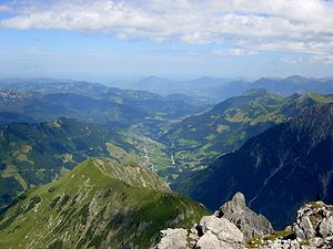
The Kleinwalsertal is in the northeast of Vorarlberg and is a side valley of the Iller, which flows north in Ulm into the Danube. In the other cardinal directions, the valley is surrounded by 2000 m high mountains. There is only a road connection to Germany Oberstdorf. The valley is a ski area and a destination for day tourists, especially from the Allgäu. Since 1891 the Kleinwalsertal has been an Austrian customs exclusion area and with the economic area Germany connected. Until the introduction of the euro, the D-Mark was legal tender.

places

- 1 Mittelberg
 . E-mail: [email protected].

 in the Wikidata database") (with the district of Baad).
(with the district of Baad). - 2 Hirschegg. beautiful little mountain village with interesting chapels.
- 3 Riezlern


The three places in the valley have been part of the municipality since 1563 (separation from the "Tannberg Court" and the formation of the "Mittelberg Court") Mittelberg summarized.
background
- From 1270: Several Walser families migrate from the (main area) Valais coming from the south (via the Tannberg and the Hochalppass) into the valley. The high valley, which was still wooded at the time and was used as a manorial hunting area, first had to be cleared by the newcomers. From then on, they manage the usable areas that were created in this way as heirs of Swabian aristocratic families (barons or counts of Rettenberg until (approx.) 1350, then owned by the nobility of Waldburg, who then sold the Breitach Valley back to the von Heimenhofen brothers (approx. 1351)).
- 1302: Probably the first chapel in Mittelberg (then 1390 consecration letter of the chapel on Mittelberg and from 1391 Mittelberg's own parish).
- 1357: the Walser received various special rights such as B. Free (lower) jurisdiction.
- 1451-1453: The valley falls to Tyrol through armed force (conquered by Duke Sigsmund of Tyrol, nephew of Emperor Friedrich III) and thus comes under Habsburg rule. The valley population then had to give up many freedoms, which were given back by Emperor Maximilian I around 1519.
- 1806: Through the Peace of Pressburg, the valley becomes part of Bavaria. The Walsers lose their previously granted rights (including jurisdiction).
- 1814: The area is returned to Austria. But also final loss of free jurisdiction.
- 1891: The customs union agreement with Germany is concluded. This ensures the free movement of agricultural products and other commercial goods and creates great economic benefits for the population. The contract can be described as the basis for economic growth (including tourism).
- 1938: Connection to the German Reich.
- 1940: The first ski or drag lift (Parsenn lift) in Riezlern goes into operation.
- World War II: The war interrupts tourism development in the Kleinwalsertal.
- Post-war period: The valley is experiencing another economic boom thanks to tourism.
- 1995: Austria joins the EU. The border, which "practically" no longer existed since the Customs Union Treaty of 1891, has finally lost its importance.
language
The official language is German.
getting there

Access is only through the area of Germany possible with the rest Austria the valley is only connected by footpaths. The only road leads from Oberstdorf into the valley (Bundesstrasse 19 or Landesstrasse 201). A road connection across the mountains to Austria was planned several times, but never realized.
Buses run into the valley from Oberstdorf train station.
mobility
Public transport
There is an exemplary bus network in the valley that can be used free of charge with the guest card:
With the "Walserbus"There is a very good range of buses across the valley both in winter and in summer. Even on secondary lines there are every half hour. The Walserbus is part of the guest card.
Tourist Attractions

- 1 High Ifen. The 2230 m Hohe Ifen with its vertically sloping rock faces is one of the most striking mountains in the Allgäu Alps.

- Gottesacker plateau. Geologically interesting is the barren karst landscape that extends between the Ifenmauer and the Obere Gottesackewalls over approx. 5 km². The Gottesacker Plateau was created by a glacier from the last Ice Age, which lay on the plateau during the Cold Age. Today it is under nature protection. Due to the risk of burglary in the karst area, do not leave the marked paths and slopes!
- Chairlift. A chair lift leads in two sections from 1275 to over 2000 m to just below the summit (summer operation only on the lower section between 1275 and 1600 m). From the mountain restaurant at 2000 m you have a wonderful view of the world of Allgäu high alps. The 2230 m high summit of Hofen Ifen, on the other hand, is reserved for sure-footed and vertigo-free mountain hikers in summer.
- Winter sports: In contrast to the Fellhorn-Kanzelwand ski area, the 21 km of slopes on the Hohe Ifen are still relatively empty (due to the limited transport capacities; as of winter 2005). There are some blue slopes, especially for beginners. For more information, see the "Alpine skiing" section at activities.
- Winter program for non-skiers: Non-skiers can also climb the 2143 m high Hahnenköpfle in winter (small pre-summit; beautiful view towards Lake Constance). There is also a winter hiking trail with a length of 3 or 5 km on the Gottesacker plateau. Info: www.ifen.info
- 2 Breitachklamm. The gorge is definitely worth a visit in both summer and winter.
- 1 Söllereckbahn. Cable car to Söllereck mountain. Summer toboggan run, climbing forest and playgrounds in summer as well as easy slopes and winter hiking trails in winter.


- 2 Kanzelwandbahn. The Fellhorn is a 2,037 meter high mountain, the Kanzelwand measures 2,036 meters. Both mountains together form the cross-border ski area Fellhorn / Kanzelwand, also known as the two-country ski region. Family run, Funslope, Easypark, Crystal Ground, night skiing and a wonderful winter hiking trail beckon in the cold season. In summer, family-friendly hiking trails with a wonderful mountain panorama beckon.

- 3 Walmendiger Horn observation box. with large cable car (in winter ski operation). Summer: summit station with viewing platform and a sun terrace. An educational alpine flower path between the mountain station and the summit cross leads past over 130 different plant species. In winter, a ski area offers a total of 10 km of slopes with a 4.2 km long valley run.

activities
- Routes for a variety of mountain sports, as well as information about huts and weather conditions, can be found on the website of the German Alpine Clubalpenvereinaktiv.com being found. With the app outdooractive the same routes can also be viewed and a mobile device can easily be used for navigation.
summer
- Mountain hiking
- Mountain hiking with mountain railways
- High Ifen (2228 m) in winter with the Ifenbahn to 2030 m, in summer only to the middle station at the Ifenhütte (1600 m). · Hike: Panoramaweg, (easy, 30 min without exertion) to Hohen Ifen (short exposed steep step, only for experienced mountain hikers) or 1 ½ hours ascent to the Bergadler mountain restaurant (2030 m). From here a round trip on the very interesting karst plateau of the Gottesacker over the Hahnenköpfle (2080 m) · Summer operation from June 26th to October 24th, 2010 · One way: € 6.50, round trip: € 8.50, Children € 3.50 / € 4.50
- Pulpit wall (2034 m) · 30 min. From the mountain station (1957 m): mountain path to the Kanzelwand with medium difficulty and surefootedness. Easy circular hiking trail, 1 ½ hours at approx. 1,900 m altitude to the Fellhornbahn, with the Fellhornbahn to the Fellhorn summit station and back to the Kanzelwandbahn. · Operation and prices of the Kanzelwandbahn such as Fellhornbahn, the ascent of the upper Fellhornbahn section is included in the price of the Kanzelwandbahn.
- Walmendinger Horn (1996 m) Summer operation from May 8th to November 7th, 2010 Ascent: € 17, ascent and descent: € 21.50, children € 6 / € 8.50
- Climb: E.g. Mindelheimer Klettersteig
- Mountain biking: Simple but also very demanding routes with many pushing and carrying passages - there are places to stop and rest.
- Rafting: Rafting is popular on the Breitach, which jumps into the Kleinwalsertal. The entrance is below the Breitachklamm.

- Canyoning: Canyoning is very popular in the Kleinwalsertal. Especially the Schwarzwasserbach below the Ifen offers different sections with different levels of difficulty.
winter
- Alpine skiing: The valley has three high alpine ski areas - Hoher Ifen, Fellhorn-Kanzelwand and Walmendinger Horn - with a total of around 120 kilometers of slopes; furthermore snowboarding, telemark etc. In the valley area between 2003 and 2008 the modern, family-friendly Heuberg Arena, i.a. with two modern lifts and a snow-making system. There are joint multi-day tickets for all ski areas. Extra day tickets are also available for the Heubergarena and the other valley lifts.
In the valley there is an extensive network of bus routes that also go to the valley stations of the ski areas.
| Surname | phone | Altitude | Σ | ||||||
|---|---|---|---|---|---|---|---|---|---|
| Fellhorn pulpit wall | — | 920 - 1,967 m | 3 | 5 | 1 | 4 | 20 | 1 | 25 km |
| High Ifen | — | 1,280 - 2,030 m | — | 2 | 2 | 10 | 7,5 | 3,5 | 21 km |
| Walmendinger Horn | — | 1,200 - 1,940 m | 1 | 2 | — | 0,5 | 10 | 0,5 | 11 km |
| Heuberg Arena and more Valley lifts | — | approx. 1,000 - 1,480 m | 1 | 2 | 16 | 35 km of slopes: especially easy and moderately difficult runs | |||
- Note: kilometers of slopes are rounded to the nearest half kilometer.
Snow phone:
Winter sports report for the Fellhorn / Kanzelwand, Walmendingerhorn and Ifen ski areas by Kleinwalsertal Bergbahn AG:
- from Germany Tel .: 700/555 33 888
- From EU countries Tel .: 43 (0) 820/949498
Fellhorn-Kanzelwald ski area
The "two-country ski area" Fellhorn-Kanzelwand is the largest of the three high alpine ski areas in the Kleinwalsertal with 25 km of slopes. From Riezlern on, the Kanzelwandbahn "dredges" away the morning rush of athletes quite well. The area, which is mostly between 1,600 m and almost 2,000 m above sea level, has mostly more demanding, medium-difficulty slopes. Experts get their money's worth here. For them, z. B. the sometimes very demanding valley run down to Riezlern, which is the longest run in the area with a length of 4.4 km. Up on Almhöhe there are several high-performance chairlifts in the wide hollow, which already belongs to Bavaria. This area is located with a great panorama of the Allgäu high Alps. Since the winter of 2006/2007, the second entrance gate to the ski area from Oberstdorf has been equipped with a high-performance small cable car in addition to the large cable car (Fellhornbahn II). In the high season, the slopes between Fellhorn and Kanzelwand are therefore very lively.
Hoher Ifen ski area


Compared to the Fellhorn-Kanzelwand ski area, the slopes on the Ifen are sometimes still relatively quiet, even in high season. The reason is the limited transport capacities. You may have to wait longer at the chairlift in the valley, depending on your arrival time, but you can go to the beautiful panorama slopes without any hassle. At the Ifen there are suitable slopes for both beginners and experts. Skiers can tackle the 1.6 km long, black Olympic slope, while beginners can have fun on the blue slopes and ski trails. Beginners in particular will enjoy the peace and quiet on the blue slopes, because the first, more advanced attempts are a lot less stressful on slopes with less traffic. During the descent, an attractive landscape panorama opens up with a wide view over the mountains of the Kleinwalsertal towards the Allgäu High Alps.
- Expansion plans for the Hoher Ifen ski area: At the latest when the expansion plans with an increase in transport capacities at the Ifen are implemented in one form or another, things will probably get more hectic on the slopes here too. Kleinwalsertaler Bergbahn AG, the sole owner of Ifen Bergbahn GmbH since 2009, is planning to expand the Hoher Ifen ski area. There are plans to connect the Walmendigerhorn with a panorama lift hanging freely over the Schwarzwassertal with the Hoher Ifen ski area halfway up. The plan for the Panoramabahn is controversial and controversial (see also Wikipedia article "Hoher Ifen"). In addition to the construction of a new small gondola lift on the Ifen, a connecting lift from the mountain station of the Heubergbahn to the valley station of the Ifenbahn at the Auenhütte is also under discussion.
Nordic skiing
Various circular cross-country trails, which are spread across the valley, are groomed. Cross-country ski run fee: This is not applicable if you have a guest card ("Allgäu-Walser-Card").
There are a total of 42 km of trails, which are spread over several circuits.
kitchen
Restaurants, fast food and cafes are abundant in every village. Every Friday from 9:00 a.m. to 12:30 p.m., Walser business people offer their mostly local and down-to-earth products / specialties at the Walser weekly market in Hirschegg - Dorfplatz. Action days enrich the program on a case-by-case basis.
nightlife
- Dancing bear. Club in Riezlern, in the basement of the casino building.Open: every Fri Sat before public holidays between 11 p.m. and 4 a.m.
- Casino Kleinwalsertal. Open: open daily from 4 p.m., day off is December 24th.
accommodation
In the valley there is a wide range of guest beds in hotels, guest houses, private rooms and holiday apartments (see Accommodation search on Kleinwalsertal Tourism).
security
There are no special safety instructions regarding crime.
climate
The best travel time for summer tourism is from June to August, as the temperatures are mild and there is hardly any rainfall. The best months for the winter season are December to February.
trips
literature
- cards: See also the section on Maps in the article Allgäu Alps.