| Manfalūṭ · منفلوط | ||
| Governorate | Asyūṭ | |
|---|---|---|
| Residents | 82.585 (2006) | |
| height | 53 m | |
| no tourist info on Wikidata: | ||
| location | ||
| ||

Manfalut (Arabic:منفلوط, Manfalūṭ) is a central egyptian City in GovernorateAsyūṭ on the western side of the Nile. In 2006 about 83,000 inhabitants lived in it. The main attraction is the city's oldest mosque, the El-Kāshif Mosque.
background
Location and importance
The city of Manfalūṭ is located about 350 kilometers south of Cairo and 27 kilometers northwest of the provincial capital Asyūṭ away on the western side of the Nile. The distance to the Nile is about two kilometers. The city is located directly on the east bank of the Ibrāhīmīya Canal, which was created in 1873 to increase the usable agricultural area. Agriculture is also the city's main livelihood. Mainly sugar cane, vegetables and fruits such as pomegranates are grown in the vicinity of the city. There are sugar factories in the city, as well as a date wine factory that meets the needs of the Coptic community.
The city achieved an upswing with agriculture. Around 1893, 13,232 residents - mainly Coptic Christians - lived here,[1] today already 82,585 (2006).[2]
The city is the seat of a Coptic Orthodox bishop. Born in 1923 and deceased in 2012, he also came from the city Schenuda III., the 117th Pope and Patriarch of Alexandria.
Origin of name
The Coptic name Ⲙⲁⲛⲃⲁⲗⲟⲧ, Manbalot, was first mentioned in a Coptic manuscript that is now in the Bibliothèque nationale de France located, mentioned.[3] The word means "sanctuary of the wild asses". The leather that was obtained from the skin of these donkeys was z. B. made into bags or used by the monks as bedding.[1] The modern name Manfalūṭ arose from Coptic.
history
The city's beginnings are in the dark. The Coptic name from Roman times and the tradition of Leo Africanus (1490–1550) make the existence of the city seem certain from at least the Greco-Roman period. Unfortunately, there are no records from contemporary Greek and Roman authors. Leo Africanus reported about the city:
- “Manf Loth, a very large and old city, was built by the Egyptians and destroyed by the Romans. The Mohammedans began with their restoration - but it is like nothing in comparison with the first times. You can still see certain thick and high columns and covered corridors with inscriptions in Egyptian. Beside the Nile are great ruins of a great building that appears to have been a temple. The inhabitants sometimes find gold, silver, and lead coins there, with Egyptian letters on one side and the heads of old kings on the other. The ground is fertile, but it is very hot there, and the crocodiles are doing great harm, and that is why the city is believed to have been abandoned by the Romans. Today's residents are pretty rich because they drift in Nigrites (this is the sub-Saharan region of West Africa) trade. "[4]
The remains described by Leo Africanus no longer exist today. But there is only nine kilometers to the west Kōm Dāra but traces of settlement that go back to prehistoric times.[5]
It is conceivable that the city was abandoned in post-Roman times. In the 13th century, however, it was settled again, like the Arab geographer Abū el-Fidāʾ (1273–1331) knew how to report:
- „Manfalut is a small town in the middle of Said (Upper Egypt), on the east side of the Nils, on the bank of the river, about a day's journey below the city of Ossiut (Siut). It has a large mosque. "[6]
There is also a report by the Arab historian from the end of the 14th and beginning of the 15th century el-Maqrīzī (1364-1442). In his main work al-Chiṭaṭ he described the relationship between Christians and Muslims as so fraternal that they offered their prayers in the same church of the monastery of Benu Kelb. At that time there was no longer a monk living in this monastery, which was probably dedicated to the Archangel Gabriel.[7]
At the time of Mamluk sultans (around 13th to 16th centuries) Manfalūṭ was also the capital of a province.[1]
The city was also used by the English traveler Richard Pococke (1704–1765) who noted that it was already a mile from the Nile.
- “Manfalouth is a mile from the river, and stops a mile around it. It's built pretty well. A casiph resides there, who rules the province. Also a bishop's seat, and around 200 Christians are in this place. Their church alone is some distance from Narach[8]where the people believe that Jesus and his parents stayed there until after Herod's death. "[9][10]
getting there
By train

Manfalūṭ is on the railway line from Cairo to Aswan and can be reached by regional trains from Asyūṭ. The 1 Manfalūṭ train station(27 ° 18 ′ 25 ″ N.30 ° 57 '58 "E.) is located on the east side of the Ibrāhīmīya Canal, about halfway between the two canal bridges.
By bus
In the area of the youth center (Arabic:مركز شباب, Markaz Shabab) are the bus and texi stops. On the one hand west of the center, directly on the street (2 27 ° 18 ′ 46 ″ N.30 ° 57 ′ 57 ″ E), on the other hand the taxi stops are located south of the center (3 27 ° 18 '42 "N.30 ° 58 ′ 0 ″ E).
In the street
Manfalūṭ is located on highway 02, which was built on the west bank of the Ibrāhīmīya Canal. The city can be reached via two bridges.
To the southwest of the city is the village of Banī ʿAdī, in which the desert slope Darb eṭ-Ṭawīl into the valley ed-Dāchla begins.
mobility
The city can be explored on foot, by car or taxi.
Tourist Attractions
El-Kāshif Mosque
The main attraction is the 1 el-Kāshif mosque(27 ° 18 ′ 46 ″ N.30 ° 58 ′ 18 ″ E), Arabic:مسجد الكاشف الكبير, Masǧid al-Kāshif al-Kabīr, „Great el-Kāshif mosque“), Which is located in the east of the city in the area of Qeiṣārīya, the bazaar district. Prince ʿAlī el-Kāschif Gamāl ed-Dīn (Arabic:الأمير علي الكاشف جمال الدين, al-Amīr ʿAlī al-Kāshif Ǧamāl ad-Dīn) left the mosque in 1772 (1176 AH) erect. It is the oldest mosque in the city.
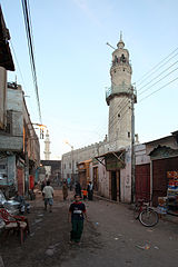
The roughly square mosque with a side length of about 20 meters has a minaret on the western tip. The minaret consists of three shafts and two whorls. The lower part, which takes up almost half of the minaret, is octagonal and is completed with the first walkway. The round segment is followed by the third, hexagonal part with the second handle and the tip. All six sides of the top part have a passage for handling.


The main entrance to the mosque is on its north side. The gate border is decorated with a brick pattern. The gate itself consists of two iron-studded wings. The mosque is completely filled by the prayer room, whose wooden ceiling, painted green and blue, is supported by four pillars. In the middle of the wooden ceiling there is a square light dome, the Sheikhah. The walls and pillars painted in different shades of green. The base of the walls is set off in dark green. There is a wooden gallery on the back wall.
The prayer niche (Mihrab) is framed by two pillars and contains not only an ornamental painting but also a sura in red color. In the area of the hemisphere there is again a decoration with black and red bricks. Above this brick decoration there is a marble plaque with a five-line inscription. In addition to the Islamic creed, this inscription also contains a reference to the builder and the year the mosque was built. To the right of the prayer niche is the wooden pulpit (Minbar).
Churches
- 2 Church of St. Virgin (كنيسة السيدة العذراء مريم, Kanīsat as-Saiyida al-ʿAḏrāʾ Maryam, Church of the Lady, the Virgin Mary) (27 ° 18 '42 "N.30 ° 58 ′ 28 ″ E)
- 3 Church of St. George (كنيسة الشهيد العظيم مارجرجس, Kanīsat al-Shahīd al-ʿaẓīm Mār Girgis, Church of the Great Martyr St George) (27 ° 18 ′ 27 ″ N.30 ° 57 '58 "E.)
- 4 Monastery of St. Virgin and St. Theodor von Schuṭb (دير والدة الإله العذراء مريم والأمير تادرس الشطبي, Dair Wālida al-ilāh al-ʿaḏrāʾ Maryam wa al-Amīr Tādrus asch-Shuṭbī, Monastery of the Mother of God, the Virgin Mary and Prince Theodor von Schuṭb). The monastery is located in the north of the city, west of the Ibrāhīmīya Canal.(27 ° 19 ′ 0 ″ N.30 ° 57 ′ 11 ″ E)
activities
Culture
- 1 youth Center(27 ° 18 ′ 44 ″ N.30 ° 58 ′ 1 ″ E), Arabic:مركز شباب, Markaz Shabab
shop
Shopping is z. B. in the market district of the city, the Qeiṣārīya, possible.
kitchen
In the area of the city and the market there are only food stalls and cafes. Restaurants can be found in Asyūṭ.
accommodation
Accommodation is usually in Asyūṭ elected.
trips
Individual evidence
- ↑ 1,01,11,2: La geographie de l’Égypte à l’époque copte. Paris: Impr. National, 1893, P. 237 f.
- ↑Egypt: Governorates & Major Cities, accessed March 10, 2013.
- ↑Coptic Manuscript No. 43, Bibliothèque nationale de France, Mss. Cop. de la Bibl. nat. nO 43, fol. 51.
- ↑: Johann Leo’s des Africaners description of Africa; First volume: which contains the translation of the text. Herborn: High school bookstore, 1805, Library of the most excellent travelogues from earlier times; 1, P. 548.
- ↑: Dara: campagnes de 1946-1948. Le Caire: Impr. Governors., 1958.
- ↑Bertuch, Friedrich Justin (Ed.): General geographical ephemeris; Volume 35. Weimar: Verl. D. Industrial comptoirs, 1811, P. 333 f. See also: : Geography d’Abulféda Traduite de l’Arabe en Francais et accompagnée de notes et d’éclaircissements; tome II. Paris: L’Imprimerie Nationale, 1848, P. 156.
- ↑al-Maqrīzī, Mss. Arab. 682, fol. 567. See also ; Brown, Robert (Ed.): The history and description of Africa and of the notable things therein contained; vol. 3. London: Hakluyt Soc., 1896, Works issued by the Hakluyt Society; 94, P. 899; 923 f., Endnote 101.
- ↑Maybe so is Deir el-Muḥarraq meant.
- ↑: D. Richard Pococke’s description of the Orient and some other countries; Part 1: From Egypt. gain: Walther, 1771 (2nd edition), P. 112 f. The last sentence has been translated incorrectly. In the original it says: "... where the common people have a notion that the holy family stay’d till the death of Herod."
- ↑: A description of the east and some other countries; Volume the First: Observations on Egypt. London: W. Bowyer, 1743, P. 75.