| ||
| Mogan | ||
| region | Canary Islands | |
|---|---|---|
| Residents | 20.487 (2020) | |
| height | 253 m | |
| no tourist info on Wikidata: | ||
| location | ||
| ||
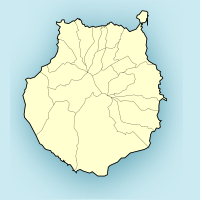
Mogan is a municipality in the southwest of Gran Canaria.
background

With an area of 172 km², Mogán is the second largest place on the island of Gran Canaria, but still unknown to most tourists. The elongated main town is located in the scenic gorge Barranco de Mogán and has almost 1,000 inhabitants. Much better known are its districts on the coast, from east to west the well-known holiday resorts Arguineguín, Puerto Rico and Puerto de Moganthat have more than 50,000 guest beds. There are also some smaller towns, some of which are on the coast like Tauro and Taurito, partly they are in the hinterland like Casas de Veneguera.
getting there
By plane
The Gran Canaria Airport is around 65 km from the village of Mogán.
In the street
The easiest way to get to the southwest of the island is via the motorway GC-1that of Las Palmas from the east coast past the airport to the south. It is completed to the town of Puerto Rico, from there you drive on the GC-500 on a winding road to Puerto de Mogan. From there the GC-200 to the main town of Mogán, the road continues afterwards La Aldea de San Nicolás and along the west coast to Agaete.
mobility
Tourist Attractions

The Barranco de Mogán is a scenic gorge that stretches inland from the coast.
- Is worth seeing in the hamlet El Molino del Viento a windmill, it was restored true to the original after a fire.
- At Pie de la Cuesta branches the GC-605 off into the hinterland, it leads past a reservoir towards Tejeda
- In the mountainous hinterland Casas de Veneguera one sees with Los Azuleos a geological feature. A small kiosk with a parking lot enables a safe break
activities
shop
kitchen
nightlife
accommodation