| location | ||
| ||
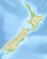
The Aoraki / Mount Cook National Park lies on the South Island of New Zealand in the New Zealand Alps.
background

in the Mackenzie District in the region Canterbury In 1953 an area of over 700 km² was declared a national park. It is the area around the 3754 m high Mount Cook, in the Maori language Aoraki called. Together with the adjacent areas of the Westland National Parks, of Fiordland National Park and des Mount Aspiring National Park he forms that Te Wahipounamu World Heritage.
landscape
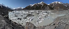
The Aoraki Mount Cook National Park comprises the core region of the Southern Alps. In this area there are 19 mountains, the peaks of which are over 3000 m high, 40% of the area is (still) glaciated, the largest of which is the Tasman glacier on the slopes of Mount Cook. The meltwater from the glaciers collects in the lakes Lake Ohau, Lake Pukaki and Lake Tekapo, the minerals carried along color them a brilliant blue.
Flora and fauna
In spring you can see the banks of rivers and lakes lined with colorful lupins. However, this wonderful natural phenomenon cannot be traced back to native plants, just like the bright yellow gorse that is often encountered. Many plants and animals have been introduced. Of course there are also native animals, so you can see them here above the tree line Kea, a species of parrot up to 50 cm tall.
climate
The main ridge of the Southern Alps forms a weather divide. While it rains relatively much on the west coast of New Zealand, this changes immediately on Mount Cook: its Maori name means Piercing the Clouds. On its eastern side, the climate is much drier. In the New Zealand winter, however, there is quite a lot of frost with snow and ice, and in the spring there can also be days of partly heavy rainfall.
getting there
The national park can be reached on the SH 80who at Twizel from SH 8 branches off and up to Mount Cook Village goes.
Fees / permits
Use of the hiking trails in the Mount Cook National Park area is free of charge. Some of the information material from the Visitor Center of the Department of Conservation in Mount Cook Village is chargeable.
mobility
Everything is within walking distance in Mount Cook Village.
Tourist Attractions
Mount Cook Village

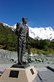
The place took care of that Hermitage Hotel educated. In addition to the hotel, there is a tourist information office and some simple accommodations. The main attraction of this village is its location at the foot of Mount Cook and the Hooker Glacier. There is a statue of the famous mountaineer in front of the Hermitage Hotel Sir Edmund Hillarywho trained regularly in these mountains. In the hotel itself there is an exhibition with exhibits on the ascent of Mount Cook and on mountain rescue.
miscellaneous
- The clear air of the mountain region reveals a fantastic starry sky at night
- Mount Cook Salmon. Salmon farming on a canal between Lake Takapo and Lake Pukaki.
activities
hikes
Several day and multi-day hikes have their starting point in or in the vicinity of Mount Cook Village (brochure).


- Bowen Bush Walk. The shortest hiking trail within Mount Cook Village with a duration of ten minutes leads through a small pine forest.
- Glencoe Walk. Behind the Hermitage Hotel, the hiking trail, which is estimated to take 30 minutes, has its starting point. After an ascent you reach the viewpoint over the Hooker Valley, Mount Cook Village and Mount Cook.
- Governors Bush Walk. The route, estimated at 45 minutes, has its starting point at the public refuge in Mount Cook Village and leads through one of the last forests with New Zealand silver beech with a lookout point.
- Red Tarns Track. The two-hour hiking trail also starts at the refuge. After a steep ascent, there is a view of the Hooker Valley and Mount Cook Village.
- Kea Point Track. The two-hour hiking trail begins below the Hermitage Hotel. Starting at Whitehorse Hill Carpark, the hike takes an hour. The path winds slightly uphill through the subalpine terrain of the Hooker Valley and ends at the lookout point on the glacier moraine of the Mueller Glacier.
- Hooker Valley Track. The four-hour hiking trail leads over two swing bridges through the Hooker Valley.
- Sealy Tarns Track. The three to four hour hiking trail branches off after two thirds of the Kea Point Track and, after a steep ascent, offers views of the entire Hooker Valley up to Hooker Lake with a view of Mount Cook.
- Ball Flat Route. Starting from the Blue Lakes Carpark, the hiking trail, estimated at around four hours (one way), follows the Tasman Glacier with viewpoints of the New Zealand Alps. One night in the historic Ball Hut (Ball hat) can be booked at the Department of Conservation Visitor Center in Mount Cook Village.
- Mueller Hut Route. The ascent to the Mueller Hut is only recommended for experienced mountaineers and hikers. The path leads uphill for around 5.2 kilometers through alpine bushland, herb meadows and scree slopes. One night in Mueller Hut (Mueller hat) can be booked at the Department of Conservation Visitor Center in Mount Cook Village.
- Ball Pass Crossing. The two to three-day trip crosses the Mount Cook mountain range (Mount Cook Range) between Hooker Valley and Tasman Valley. The path is accessible from December and March (information).
Sightseeing flights
- New Zealand Helicopter Scenic Flights. Sightseeing flights, landing on the glaciers and heli-skiing.
- Mount Cook Ski Planes. Scenic flights, transportation of climbers, and landing on Tasman Glacier.
- Mountain Helicopters. Sightseeing flights, landing on the glaciers and heli-skiing.
- Southern Alps Air. Sightseeing flights.
Guided tours
- Glacier Explorer. Hike to Tasman or Hooker glaciers and cruise through glacial lakes.
shop
in the Hotel Herimitage there is a shop for trekking equipment and souvenirs.
kitchen
- Chamois - Burger and Pizza Restaurant at Mount Cook Lodge & Motel
- Alpine restaurant - Buffet restaurant in the Hotel Herimitage
- Panorama restaurant - A la carte restaurant in the Hotel Herimitage
accommodation
- Whitehorse Hill Campground. At the end of the Hooker Valley, run by the Department of Conservation campsite with very basic facilities.
- Glentanner Motor Camp. Campsite at the northern end of Lake Pukaki with sleeping cabins for backpackers and riding facilities.
- YHA Mount Cook Youth Hostel. Accommodation for backpackers.
- Mount Cook Lodge & Motels. Largest motel on site with breakfast option and restaurant.
- Hotel Hermitage. Upscale hotel with Edmund Hillary Center, museum, cinema and planetarium.

Hermitage Hotel

Hermitage Hotel showroom
Sir Edmund Hillary


Alpine huts

Mount Cook Village is the starting point for mountaineers. The Department of Conservation operates numerous huts or bivouacs in the Mount Cook area, which must be booked at the visitor center in Mount Cook Village.
- Ball hat. Six beds in bunk beds.
- Barron saddle hat. 16 beds in bunk beds.
- Copland Shelter. Eight sleeping places in double bunk beds.
- Empress hat. 24 beds in bunk beds.
- Gardiner hat. 16 beds in bunk beds.
- Godley hat. 16 beds in bunk beds.
- Haast hat. Eight sleeping places in double bunk beds.
- Kelman hat. 44 beds in bunk beds.
- Liebig hat. 12 beds in bunk beds.
- Mueller Hut. 56 beds in bunk beds and cooking facilities.
- Murchison hat. 20 beds in bunk beds.
- Onslow Hut (Steffan Memorial Hut). Eight sleeping places in double bunk beds.
- Platform hat. 66 beds in bunk beds.
- Red stag hat. Eight sleeping places in double bunk beds.
- Sefton Bivy. Eight sleeping places in double bunk beds.
- Tasman Saddle Hat. 28 beds in bunk beds.