| Motya | |
 | |
Location .png/250px-Mozia_(posizione).png) | |
| State | Italy |
|---|---|
| Region | Sicily |
| Territory | Trapanese |
| Surface | 0.45 km² |
| Institutional website | |
Motya is an archaeological site of the Sicily.
To know
Mozia is an ancient Phoenician settlement on the island of San Pantaleo near Marsala.
Geographical notes
Mozia is located off the coast of Marsala where are the Stagone Islands with the surrounding lagoon. The four islands comprise theSan Pantaleo island with the remains of the historic Mozia, theSanta Maria Island, the smallest island The Schola with the remains of some buildings and a cistern from the 1930s and the large lagoon delimited byBig Island. This island complex is part of the Nature reserve oriented "Stagnone of Marsala Islands".
Background

Motya was founded around 800 BC. by the Phoenicians, around 600 BC. from Carthage which expanded the settlement into a fortified city. Mozia was surrounded by a 2.5 km long wall and was connected to the mainland by a road. The latter can still be seen, but is now below sea level due to tectonic changes. The city became one of the most important trading ports in the region.
In 397 BC Motya was conquered and destroyed by the tyrant Dionysius I of Syracuse, the inhabitants managed to escape and built the city of Lilybaion on the mainland at Capo Boeo. Western Sicily, including the island, was subsequently reconquered by the Carthaginians, but the city of Mozia was never rebuilt and the remains fell into disrepair.
In the seventeenth century it was assumed that the site of ancient Mozia was on the island of San Pantaleo, it was only in 1883 that Innocenzo Coglitore was able to ascertain the fact that the island was the site of ancient Mozia. The island was then bought in 1906 by Joseph Whitaker, who had grown rich in Vienna, and from 1906 onwards systematic excavations were carried out. The finds found are in the Whitaker Museum on the island of Mozia, still owned by the family today. The Whitaker family in fact resides in a group of buildings on the island.
How to get
| To learn more, see: Oriented_Natural_Reserve_ "Stagnone_Islands_of_Marsala" #How to get there. |
- 1 Landing jetty. Here all the boats that come from the mainland arrive.
Permits / Rates
- 2 Ticket office, 393496256508, 393476551666, @[email protected].
 adults € 6, students € 5 (Sep 2020).
  Mon-Sun 10:00 - 14:00 and 15:00 - 19:00. The ticket allows entry to the museum and the archaeological area. Ferry is not included.
How to get around

Inside the island you can move only on foot.
What see
The things to see on this page are arranged following an order of visit that starting from the museum follows a coastal path in a clockwise direction.


 1 Whitaker Museum. visit included in the entrance ticket. Most of the finds from the island's excavations are exhibited at the museum. The history of the Punic settlement of the island is presented but above all theEphebe of Mozia, a life-size marble statue from 450-440 BC. found in 1979. It probably represents a young charioteer, a god or a ruler. Also exhibited are the sculptures of two lions attacking a bull; this is one of the first pieces to have been recovered by Rosario Alagna di Mozia in 1793. The originals of numerous tombstones from the necropolis north of the island are also exhibited.
- On the back of the museum is the collection of Mozia finds; it is not exhibited according to modern museum methods, but according to the style of the early twentieth century, that is, in shop windows.


- 2 House of mosaics (just south of the museum). In the building with a colonnade there is a pebble mosaic floor with depictions of wild animals in hunting (a lion attacks a cattle, a bird of prey, a deer; perhaps from the 3rd century BC), these are domestic rooms with three large pithoi (storage vessels) which were located in the southwestern part of the house.

- 3 Barracks (reachable along the south coast). It is a defensive structure that was attached to a tower integrated into the south wall. A corridor leads north to a staircase that goes up to an upper floor. In this corridor there were three rooms on the left and at least two more rooms on the east side. The Punic construction method found in many places in Mozia ("a teleio", large uniform stone blocks with finer masonry in the middle) is clearly visible in this structure. The "Casermetta" was probably destroyed by a fire, perhaps during the siege of the island by the Syracusans.

- 4 Southern gate. It consisted of two bastions, the west tower was also used to defend the Cothon area. The stone walls were raised with battlements and probably with brick structures in the upper part.
- To the north of the south gate there are rare remains of difficult-to-class residential buildings; residential buildings may have collapsed when the door area was built.

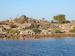
.png/220px-Isola_di_Mozia_(Mothia).png)
- 5 Kothon (Cothon) (in the south of the island). It is an artificial reservoir that has long occupied archaeologists; the first excavations were carried out under Joseph Whitaker as early as 1906/07. The reservoir was fed by a source of fresh water and closed with masonry and a drain towards the access area. The 52.5 x 35.7 m basin dug into the rock with a maximum depth of 2.5 m is bordered by carefully excavated limestone blocks and has been closed with a wall at the south end. A 23.5 m long connection channel. The Kothon was filled with fresh water from a spring slightly to the north which certainly served for worship purposes. The hypothesis previously hypothesized of its use as a port had to be rejected, before the island sank (a phenomenon that was accompanied by the flooding of the access road that led to the island from the north) the water level was certainly 1 m lower than today and the entry of ships into the basin was (unlike previous reconstructions) impossible. The complex was probably built much later, that is, after the city was captured and destroyed by Dionysus in 397 BC, the area was then used as a dock for boat repairs, as evidenced by the changes to the walls.
- According to the most recent findings made by the Sapienza University of Rome in 2002/12, all around the Kothon the area was sacred. The "Temenos", the temple area, was enclosed by a semicircular wall which was unearthed. In fact, next to the Kothon there are two temples.

- 6 Temple of Baal (Next to the Kothon). Baal was a Punic deity equated to the god of the sea and the underworld for the Greeks. Proof of his dedication was the discovery in a vase of an inscription "consecrated to Belios".

- 7 Temple of Astrarte (Next to the temple of Baal). The Punic goddess Astarte was considered the great mother or goddess of fertility. In the Hellenistic period it was associated with Aphrodite.
- 8 Zone B homes. Group of dwellings.
- 9 Zone D homes. Here is a large country house with a chapel and a bathroom from the 4th century BC. Behind the Zone D settlement, a path leads north.
- 10 Zone F homes. Another residential area a short distance from the Tophet.


- 11 Tophet. The Tophet is a Phoenician sanctuary and burial place, used in different phases over the centuries and extended several times. At the time it was located on the outskirts of the city on the north coast, the area was repeatedly terraced and filled in. One part of the area is occupied by the sanctuary, the other part by the urn field. The tombs can be found in the form of ceramic vessels, marked with tombstones, in which reference is made to the Phoenician deity Baal Hamon (the originals can be seen in the Whitaker Museum, those on the spot have been replaced by replicas), and some " boxes "made of three stone slabs with a cover to mark the places of the graves. Due to the large number of tombs for children and animal bones, the hypothesis that these may have been sacrificed for a ritual or if they were mere child burials is still under discussion (the legend of child sacrifice was given to the Phoenicians by the Greeks).
- Various stages of development of the area emerge from the archaeological excavations:
- in the lower layer (phase A, 750-520 BC) the tophet consisted of a trapezoidal area with an elongated building on the west side. From the lowest level VII with scattered burials, the burials up to level V became denser and the first gravestones were found.
- in the next phase (phase B, 520 - 397 BC) the sanctuary was enlarged: towers were added to the east and west and a temple or sanctuary in the area of the west side and the sacred area was enlarged up to the surrounding walls. The original burial ground was not touched, the burials took place along the sides. Steles with representations of human figures were increasingly set up. The phase ended with the capture of the city by the troops of Dionysius.
- in the last phase (phase C, 397 - about 300 BC), the burial place finds its intended use after only one year of occupation by the Syracusans. The burials take place mainly in ceramic urns in a layer that extends over the entire former sanctuary; the masonry is repaired with building material from other buildings.

- 12 Necropolis. From the 8th to the 6th century BC, burials were carried out there, even before the construction of the city walls. Deo stone sarcophagi were found as burial witnesses and the cremation ashes were placed in ceramic urns.
- 13 Quarter of the artisans. About twenty mostly oval pits up to 2m deep, water tanks and remains of purple snails (Bolinus brandaris) indicate that dyers and furriers had their workshops there. The extraction of purple was a specialty of the Phoenicians from the area of today Lebanon since ancient times.
- 14 Craft districts of potters. There were several structures that potters needed to practice their profession: several kilns and pits with the supply of clay and sand for the production of pottery. A smaller kiln in the southwest corner has been closed since ancient times and a larger kiln was found in the southeast of the excavated area. The ceramics were worked in this area from the 6th century BC. until the destruction of the city in 397 BC.
- Among the rubble deposited in the so-called Zone K after the destruction of the city, a column capital and above all the marble statue of "Efebo di Mozia" were found, which is exhibited in the museum.

- 15 Sanctuary of the Capiddazzu. This sanctuary is dated to an early phase of the 7th century BC. In it there are 30 cm deep wells with bones of sheep and cattle, probably killed in sacrificial rites. A first building always from the 7th century BC. it has been rebuilt several times. The three-part building is still recognizable today through a surrounding free space that dates back to the 4th century BC.
- The road south of the sanctuary leads directly to the north gate and the road connecting to the mainland.

- 16 North gate. This door dates back to the 5th century BC. and includes two bastions. The construction method was with large stone blocks and masonry of smaller stones in the middle (opus africanum) is clearly recognizable. Near the north gate, there are two shrines with an altar. The door was made up of a succession of several doors, of which the stones that mark the end of the door were found.

- 17 Submerged road (in front of the north gate). This ancient road connected the city of Mozia to the mainland. In the past you could get to the Phoenician city of the island without getting your feet wet, as the subsidence of the land in the last two thousand and a half years, led to the sinking below sea level, in fact it is located about 1 m below the sea level. surface of the water. In the 70s Sicilian carts with high wheels were still produced to reach the island of Mozia.
- The road built in the middle of the 6th century BC it is 1.7 km long and 7 m wide, small walls bordered the road like curbs. A platform was found about 500m from the north gate, the purpose of which is unclear. There is also a Punic necropolis on the mainland at the end of the road.

- 18 Buildings. The meaning of which is not yet clear, they were discovered southeast of the north gate.
- 19 East Tower. This tower has an external staircase that dates back to the 5th century BC. erected in the last phase of the construction of the city fortifications.

- 20 Fortifications of the city. In the eastern part of the island the city walls are best preserved and are visible from the path along the east coast to the pier, they originally enclosed the entire island. In the first and second phase of the city fortifications, the walls were built with irregular stones of small and medium size, the width of the wall was about 2.60 m, so in phases three and four the walls were built with square stones such as " opus quadratum "and the towers were rectangular and in the last phase square with an edge length of up to 12 m.
- 21 House of the amphorae (just north of the museum). It includes a larger building in which numerous amphorae and other probable residential buildings were found.
What to do
- Along the rocky coast you can theoretically cool off from the summer heat in the water, but there is no real sandy beach and no showers.
Shopping
- Specialized books can be purchased at the museum shop, a sitemap is available free of charge.
Where to eat
- 1 Bars and cafes.
Where stay
There are no accommodation facilities on the island, accommodation can be found in the nearby Marsala or a Trapani .
Safety
It is not recommended to visit the island in the summer during the hottest hours. The heat and the absence of shaded spots make the visit exhausting and difficult. Bring a bottle of water with you as the paths are not always close to the bar. Likewise in case of bad weather the site is totally exposed to the elements.
Disembarking with a private boat and visiting the island without paying an entrance ticket is forbidden!
How to keep in touch
Around
The nearby cities of Trapani is Marsala. In Marsala those interested in Punic culture should visit the museum with the remains of a Punic ship.