| Mulegns | ||
 | ||
Coat of arms  | ||
| State | Switzerland | |
|---|---|---|
| Federated state | Canton of Grisons | |
| Region | Albula | |
| Altitude | 1,461 m (4,859 ft) m a.s.l. | |
| Surface | 33.79 km² | |
| Inhabitants | 26 (2014) | |
| Prefix tel | 41 081 | |
| POSTAL CODE | 7455 | |
| Time zone | UTC 1 | |
| Patron | SS. Gaudenzio and Francesco | |
Position
| ||
| Tourism site | ||
Mulegns ((DE) Mühlen or (IT) Molini), is the smallest municipality of the Canton of Grisons, in the Federation Switzerland.
To know
In the village of Mulegns (known in Italian as Molini until 1943) there are 22 houses of which 13 are holiday homes.
Geographical notes
In the upper part of Val Sursette ((RM) Surses is Surgôt, (DE) Oberhalbstein but until 1359 Oberhalb dem Stain, until 1258 (THERE) Suprasaxo; literally "above the wood"), above the Tinzen wood, there is the road village of Mulegns; located on the left orographic side of the valley. The lateral valley Val Faller it is part of the municipal territory of M. which extends west / south-west from the village; The center is crossed by the Faller torrent which flows, exiting to the east from M., into the Giulia torrent ((DE) Julia, (RM) Gelgia), in the Val Sursette. The village is located on the road to the Passo del Giulia, ((RM) Passed by Gelgia at 2,284 m, 7,493 pd a.s.l.) and the Passo del Settimo, ((RM) Pass from Sept. a (2,310 m, 7,579 pd a.s.l.). The highest point in the town is Pizzo Platta. With its 3,392 m, 11,129 pd s.l.m. in height, it is the highest mountain in the Platta Alps in the western Rhaetian Alps.
When to go
Background
A first original settlement was built in 600-500 BC. in Val Faller with small copper foundries. The current village was founded by the Walser in the sixteenth century, in 1521. In the nineteenth century in M. there was a place to change horses (with stables that housed up to 150 horses) at the hotel "Löwe", which was frequented by well-known personalities. The opening of the Albula railway (in 1903) marked the beginning of the depopulation of the locality. At the beginning of the 21st century, only a few peasants resided in M. The pastures of Val Faller, uninhabited since the 18th century, are rented out and the mountain pastures are exploited.
How to orient yourself
Neighborhoods
- Arnoz (village in Val Faller),
- Oberdorf,
- Unterdorf,
- Plang ((RM) plain, hamlet in Val Faller),
- Tga ((RM) house, hamlet in Val Faller).
How to get
By car
Coming from the South; from Milan, passing through the Val Bregaglia afterwards Chiavenna, it takes 4-5 hours by car. Being a road village, around 4000 vehicles pass through the village during the holiday periods on weekends.
On the train
The nearest train station is located at Tiefencastel on the railway axis of the Albula Railway.
By bus
By Postbus from the train station. Normal ticket price from Tiefencastel station to Mulegns: 11.80 CHF (price at 2014-12).
How to get around
By public transport
The village has only one stop, the public road transport service, the post bus, managed by the company Postbus SA (PAG).
 182 line Chur(Chur) ↔ Lenzerheide ↔ Tiefencastel ↔ Savognin ↔ Mulegns ↔ Bivio ↔ Julier Pass (Passo del Giulia) ↔ St. Moritz.
What see
- 1 Plateau of Val Faller (unpaved roadway from Mulegns.). The plateau at 1,950 m, 6,398 pd a.s.l. with Walser settlements, once inhabited all year round, it includes three hamlets.
Religious places
- 2 Parish church of SS. Gaudenzio and Francesco ((DE) Pfarrkirche hl. Gaudentius und hl. Franziskus, (RM) Baselgia Son Gudintg and Son Francestg), Mulegns Unterdorf (downstream, just outside the village). Baroque construction of 1643 by the Capuchins, who replaced the ancient late-medieval church of S. Gaudenzio with the baroque church of S. Francesco (today Saints Gaudenzio and Francesco). of the Roman Catholic Church, masses are practiced alternately by a priest in congregation with the church in the nearby village of Sur.

- 3 Chapel of the Visitation and S. Rocco ((DE) Kapelle Maria Heimsuchung und hl. Rochus), Mulegns Tga (right after the first settlement of Tga at the beginning of the Val Faller plateau), ☎ 41 816 845 332 (Paulina Jegher). There is an altar picture from 1760 on display. The chapel is kept closed; however, the key can be obtained, down in Mulegns, from the Mesmerin, Sign. Paulina Jegher.
Events and parties
What to do
Summer
- Excursions. Molini is the ideal starting point for numerous hikes in the Val Faller - an oasis of tranquility with three small Walser settlements.
Winter
- Cross country skiing. Passing from M. here to Savognin there are about 26 km of groomed trails for classic and skating style cross-country skiing.
Shopping
Products obtained from raw materials from the region of natural park of Ela[1].
- Giatgen Poltera, Pro Sot 4, ☎ 41 794 027 614, @[email protected]. Farmer producing cow alp cheese.
How to have fun
Where to eat
- 1 Wanderhütte Piz Platta, Mulegns Tga, ☎ 41 816 845 595.
 Summer: early July to mid-October; Winter: on request only. Alpine inn, managed by Poltera Adolf and Margrit. Ideal place to eat in a very quiet place on the plateau of the lateral valley of Fallers.
Where stay
Average prices
 |  |
- 1 Posthotel "Löwe" ("Leone" postal hotel), Julierstraſʒe 14, ☎ 41 816 845 141.
 summer 75.- CHF pP, winter 65.- CHF pP. Well-kept hotel with 8 double bedrooms, in a mountain setting with typical liberty style furnishings. It offers refreshment services but by reservation only.
Safety
How to keep in touch
Around
- 4 Ela park. It is a regional natural park, located in the Albula Valley and Val Sursette, which with its 548 square kilometers is the largest regional natural park in Switzerland.


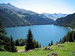
- 5 Artificial lake of Marmorera ((RM) Lai da Murmarera; (DE) Marmorera Stausee). The basin, 91 meters high, created in 1950 by the dam with a dam of loose materials, sometimes called the Castiletto dam, submerged the old village of Marmorera and the plateau with 60 million m³ of water. In summer there are alpine diving courses organized by the Poseidon school in Zurich.
Useful information
The main languages spoken on the spot are the dialectal form of Romansh spoken locally and Surmiran ((RM) surmiran). Second spoken language is the upper alemanno. The use of surmirano, like all other Romansh idioms, has dropped. During the second half of the last century, a strong Germanization took place in central Grisons (especially in today's Albula district). In the local language, a single weekly newspaper (from 1946) comes out, titled The Page from Surmeir.