
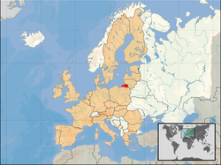
| Kaliningrad | |
 | |
| location | |
 | |
| Flag | |
 | |
| Main information | |
| Capital city | Kaliningrad |
| Surface | 15 096 |
| Population | 994 599 |
| Tongue | Russian |
| Time zone | Russian time zone, Moscow time-1, UTC 2 |
| Time zone | Russian time zone, Moscow time-1, UTC 2 |
Kaliningrad - an administrative unit Of the Russian Federation, Russian exclave of w Central Europe, at the Baltic sea.
Characteristic
Geography
The region covers an area of 15,096 km² (approximately 13,300 km² excluding sea bays) and is situated on the The Baltic Sea. Kaliningrad Oblast is the most western region of Russia. The area of the oblast is separated from the rest of the country by the areas of independent states and has no land connection with the main part of the Russian state, and as such is an exclave.
The circuit borders on Lithuania and Poland. The region includes a 147 km long section of the Baltic Sea coast.
Climate
The region has a temperate climate, transitional between maritime and moderately continental.
The average annual air temperature is 8 C. The average temperature of the coldest month - January - is from -3 C on the coast to -5 C inland. The average temperature in July ranges from 15 C on the coast to 17 C in the south.
700 mm of rainfall per year is recorded in the region.
History
The history of the district begins in 1255, when the Königsberg Teutonic castle was founded in today's Kaliningrad (Polish: Königsberg). At the beginning of the Middle Ages, the area of the present district was inhabited by the Baltic Prussians, who were conquered by the Teutonic Knights in the 13th century. As a result of Germanization and German colonization in the 16th century, the area of today's oblast becomes an area inhabited mainly by the German population. However, the second half of the 18th century is coming, when Konigsberg falls into the hands of Russia for the first time. In 1755, Tsarina Elisabeth declares East Prussia a Russian province and calls it New Russia. In 1762, Królewiec returns to Germany.

At the end of World War II, the Red Army occupied the oblast. The capital of the German province of East Prussia was conquered after a long siege on April 9, 1945. After the war, under the Potsdam Treaty, the province was liquidated, and its northern part was transferred to the USSR. The Soviet Union received about 1/3 of the lands of former East Prussia; these areas are now the area of the district. On the territory of the lands transferred to the USSR, the Königsberg Special Military District (rus. Konigsberg особыйв оенный округ), which, contrary to its name, also dealt with administration and civil matters. The oblast was formally established on April 7, 1946 as part of the territory of the Russian Soviet Federative Socialist Republic (within the USSR), under the name Кёнигсбергская область (trans. Kieningsborskaja region '). As a result of changing the name of the city to Kaliningrad (July 4, 1946), it was created Kaliningrad. At the same time, the names of virtually all localities in the oblast were changed. Already in August of the same year, the process of active mass influx of people from 27 oblasts of Russia, 8 oblasts of Belarus and 4 autonomous republics of the USSR began. This determined the multinational structure of the region's population. By 1947, virtually all of the German population had been displaced; settlers from various parts of the USSR settled in this area, but mainly Russians.
After the expulsion of the Germans, the Kaliningrad District was closed to foreigners until 1991. Air connections led only eastwards, only Soviet ships called at the port, and many international rail and road routes ended at the border with Poland. This situation was determined by the strategic importance of the oblast as the place where the Baltic fleet of the USSR and the state's land and air forces were stationed.
The situation of the Kaliningrad Oblast began to change at the turn of the 1980s and 1990s. The collapse of the USSR put the region at the center of political discussions. After Lithuania regained independence, the oblast was separated from Russia.
Economy

In 1996, a Special Economic Zone was established. Its aim is to accelerate the socio-economic development of this region.
Until 2006, the import of products to the Oblast was exempt from import duties.
Compared to the rest of Russia, the oblast has a well-developed small business sector. There are twice as many of them as the average in Russia (23.5 per 1000 inhabitants against the national average of 11 per 1000) and they generate approx. 35% of the exclave's GDP (on average only 17% in Russia).
Due to the oblast's isolation from the rest of the country and the associated higher costs of running a business (energy, transit and import), as well as difficulties typical of the entire country (corruption, low level of protection of property rights, volatility of law), the oblast enjoys moderate interest of foreign investors. But, interestingly, there is a car production plant in Kaliningrad Awtotorwhich produce (under license) cars for many important manufacturers, incl. BMW, Kia or General Motors.
Drive
By car
Several roads run from the territory of Poland to the Kaliningrad Oblast. They are, among others E28 (running from Elbląg), DK51 (running from Bartoszyce) and DK65 (running from Elk). Unfortunately, there is a border crossing on each of them.
By plane
The largest airport is Kaliningrad.
By ship
An administrative division

After the reform in 2007, the Kaliningrad Oblast is administratively divided into 15 districts; The 6 largest cities are not included in this division and constitute cities separated with district rights; and the city of Kaliningrad. The separated cities include: Kaliningrad, Yantarnyj, Ladushkin, Mamonovo, Pionierskij, Sovetsk and Svetlyj.
Cities
Interesting places
- Curonian Spit
.jpg/220px-Lake_Vistytis_(Vist1).jpg) Lake Wisztynieckie
Lake Wisztynieckie - The Vistula Spit
- Lake Wisztyniec
- Lake Siniawińskie
- Romnicka Forest
- Swamps and peat bogs on the Timber River
- Kaliningrad (Cathedral, St. Luisa Church, Royal Gate, Philharmonic Hall, Amber Museum, ZOO, former barracks)
- Sowieck (Theater, Queen Louise Bridge, Castle Ruins, Cathedral of the Three Holy Hierarchs, Military Museum, City History Museum)
- Chernyakhovsk (Ruins of the Teutonic Castle, St. Bruno's Church, St. Michael the Archangel's Church, Georgenburg Castle)
- Seaside resorts (Jantarnyj, Bałtyjsk, Pionierskij, Primorsk, Tryszkajmy)
.jpg/220px-Lake_Vistytis_(Vist1).jpg)
Transport

Road transport
There is a fairly dense network of paved roads in the oblast, dating back to the period when the area of today's oblast belonged to the German state. As the roads built by the Germans do not meet today's Russian standards in terms of width and because they are characterized by a large number of bends, most roads in the region have a speed limit of 70 km / h (unlike in other parts of the country, where the speed limit is usually is 90 km / h).
Important roads:
- А-229: Kaliningrad – Znamensk – Chernyakhovsk – Gusev – Nesterov - Lithuanian border (and further towards: Vilnius and Minsk)
- А-216: Kaliningrad - Znamensk - Tałpaki – Bolszakowo – Soviet - Lithuanian border (and further towards Saulov and Riga)
- Kaliningrad - Zelenogradsk - Rybaczyj - Lithuanian border (and further towards Klaipeda)
- Kaliningrad - Ladushkin – Mamonovo - Polish border (and further towards Elbląg and Gdansk)
- Kaliningrad - Bagrationovsk - Polish border (and further towards Of Warsaw)
In addition, there is an unfinished road in the oblast, which is a highway that was once planned to connect Królewiec with Berlin, called "Barge". This road connects with the Polish expressway S22 through the border crossing Grzechotki - Mamonowo II, opened on December 3, 2010.

Railway transport
Rail transport is used primarily for freight transport between the Oblast and neighboring countries and the rest of Russia. In addition, this type of transport plays an important role in passenger transport, both within the region and abroad (including journeys to the rest of Russia). Trains depart from Kaliningrad to both the main cities of Russia (Moscow and Saint Petersburg) as well as foreign cities (Vilnius, Minsk, and formerly also to Gdynia and Berlin).
In the past, the railway network covering the oblast was much denser, but some connections were closed and dismantled in the first post-war years; Also, shortly after the collapse of the USSR, some of the unprofitable connections were closed.
The following track sections are currently in operation:
- Kaliningrad - Chernyakhovsk - Lithuanian border
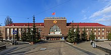 Kaliningrad Passażyrskij station
 - Kaliningrad - Mamonovo - Polish border
- Kaliningrad - Bagrationowsk - Polish border
- Kaliningrad - Primorsk – Baltiysk
- Kaliningrad - Guryevsk - Polessk - Swietłyj - Soviet - Lithuanian border
- Chernyakhovsk - Soviet - Lithuanian border
- Chernyakhovsk - Zeleznodorozny - Polish border
- Kaliningrad - Zelenogradsk – Pionierskij - Svetlogorsk (electrified line)
- Kaliningrad - Pionierskij (electrified line)

The largest railway junctions are Kaliningrad, where 8 railway lines converge, and Chernyakhovsk (4 lines)
Water transport
Water transport in the oblast should be divided into sea and inland transport.
Kaliningrad is the main commodity seaport of the region, and important ports are also located in Pionierski and Baltiysk. Kaliningrad is the second largest Russian seaport in the Baltic Sea. There is a ferry from Bałtiysk to Saint Petersburg; the city also has a passenger connection with Gdynia.
There are river ports in Kaliningrad, Chernyakhovsk and the Soviet Union. Sailing takes place only on Pregola and Nemunas. Inland navigation is of limited importance for transport; this route transports only a small part of the loads that move within the territory of the oblast; there is no inland passenger navigation.
In the summer, hydrofoils operated by Polish carriers run between Kaliningrad, Frombork and Elbląg on the waters of the Vistula Lagoon.
Shopping
When planning a trip, it is worth trying to figure out what costs should be set in the place you plan to visit. When it comes to prices in the Kaliningrad Oblast, they are very similar to those in Polish stores. Only bread, butter, eggs, tea, sweets and some vegetables and alcohol are more expensive than in Poland.
During your stay, it is worth buying a souvenir of very popular amber or popular Russian souvenirs (matryoshkas, samovars, sweets and wooden dishes).
Gastronomy
Königsberg kitchen
This regional variety of Baltic cuisine has many elements of Russian, Polish, Baltic and Prussian cuisine. Due to the region's location, there are numerous fish (herring, sprat and cod) caught from the Baltic Sea. There are also elements of German culture - Königsberg meatballs - known in Germany as Königsberger Klopse. Local gastronomy has a lot of forgotten dishes, such as Königsberg tripe or Königsberg marzipan. Currently, the cuisine of the Kaliningrad Oblast is strongly influenced by Russian influences (e.g. caviar is common), and from most restaurants in the region, unfortunately only a small part still serves native dishes or does so because of tourists.