- For other places of the same name, see Glacier National Park.
| Glacier National Park (Glacier National Park (in)) | |
 | |
| Rogers Pass | |
| Information | |
| Country | |
|---|---|
| Region | Kootenays |
| IUCN Category | II (National Park) |
| Administration | Parks Canada |
| Area | 1 349 km² |
| Tourist information office | Revelstoke. E-mail: [email protected] |
| Location | |
 51 ° 15 ′ 36 ″ N 117 ° 34 ′ 48 ″ W | |
| Official site | |
the glacier national park is a national park of canada located in the heart of the Columbia mountain range in British Columbia. It is considered to be the cradle of mountaineering and glaciology in North America. It is famous for its high mountains, glaciers, deep valleys filled with ancient forests and caves. Its history is closely linked to that of the two main transport routes of the Canada, namely the Canadian Pacific Railway and the Trans-Canada Highway.
Understand

Glacier National Park is located 450 km northeast of Vancouver in the Columbia Mountain Range and it covers an area of 1 349 km2. It is best known for its deep valleys, thick coniferous forests and imposing mountain landscapes. It includes Mount Sir Donald whose summit is at an altitude of 3 284 m which stands above Rogers Pass which is crossed by the Trans-Canada Highway. From there, one can also see the Illecillewaet Icefield, the best-known glacier in the park. The highest mountain in the park is Mount Dawson at 3 377 m.
The park is open year round, but many facilities are inaccessible from October to May due to snow. No camping infrastructure is maintained during the winter season. It is visited by more than 640,000 people per year, making it the fifth most visited national park and national marine conservation area in Canada. The backcountry of the park is visited by 60,000 people by years of which 15,000 skiers and snowboarders. The park is jointly administered with the Mount Revelstoke National Park from Revelstoke by Parks Canada, an agency of the Canadian Department of the Environment.
The park's main information center is the Rogers Pass Discovery Center (see section To see below).
Flora and fauna

According to the Commission for Environmental Cooperation, the park is located in the Columbia Range / Northern Rockies Level III ecoregion of the Northwest Wooded Mountains while the Canadian ecology framework locates it instead in the Columbia Highlands and Range Columbia. It is a series of links and furrows. This ecoregion is characterized by its complex ecosystems, tiered according to altitude. The valley floor vegetation cover is made up of western hemlock, western red cedar, blue Douglas-fir, silver pine and western larch. As for the subalpine layer, it is mainly composed of Engelmann spruce, subalpine fir and lodgepole pine. the World Wide Fund for Nature ranks the park in the North Central Rocky Mountain Forest ecoregion. In all, the park includes 546 species vascular plants, 36 species liverworts, 130 species foams, 129 species of lichens and around 1,000 species of mushrooms. The only plant considered at risk is whitebark pine (Pinus albicaulis).
Glacier Mountain and Mount Revelstoke are frequented by 53 species of mammals. The ungulates that frequent the park are the mountain goat (Oreamnos americanus) and the woodland caribou (Rangifer tarandus caribou) which are found in the mountain ranges as well as the mule deer (Odocoileus hemionus), white-tailed deer (Odocoileus virginianus), elk (Cervus canadensis) and moose (Alces americanus) in the Beaver River Valley. Among the carnivores, we find the grizzly bear (Ursus arctos horribilis), the black bear (Ursus americanus), the gray wolf (Canis lupus), the coyote (Canis latrans), the Canadian lynx (Lynx canadensis), wolverine (Gulo gulo) and the long-tailed weasel (Mustela frenata). Among the smallest mammals is the Canadian beaver (Beaver canadensis), the muskrat (Ondatra zibethicus), the Columbia ground squirrel (Spermophilus columbianus), the American pika (Ochotona princeps), the snowshoe hare (Lepus americanus) and the Nordic vespertilion (Myotis septentrionalis). The mammals considered at risk are the grizzly bear, wolverine and woodland caribou. The censuses made it possible to enumerate 185 species of birds. Only two species of reptiles and four species of amphibians frequent the park.
Story
The park was established in 1886 following the construction of the first transcontinental railway in Canada, the Canadian Pacific Railway. Trails and a hotel were built there to attract tourists who came to admire the Selkirk Range and the Illecillewaet Glacier. However, the construction of the Connaught Tunnel in 1916 caused the decline in tourism and the closure of most of the park's infrastructure. The construction of the Trans-Canada Highway, inaugurated in 1962, crossing the park, reintroduced mass tourism. Glacier National Park is the second oldest national park of canada, after that of Banff.
Weather
| J | F | M | TO | M | J | J | TO | S | O | NOT | D |
Temperature diagram in ° C | |||||||||||
-3.6 -9.6 | 1.6 -6.5 | 6.6 -2.8 | 11 0.2 | 15.9 3.9 | 19.6 5.9 | 19.4 5.8 | 13.3 2.3 | 5 -1.4 | -2.9 -6.8 | -7.2 -11.6 | |
| 223 | 156 | 112 | 75 | 71 | 96 | 92 | 92 | 90 | 130 | 197 | 213 |
Snow precipitation diagram in cm | |||||||||||
| 217 | 152 | 95 | 41 | 9 | 0 | 0 | 0 | 2 | 45 | 165 | 207 |
| Temp. min. annual mean in ° C -2.7 | |||||||||||
| Annual precipitation in mm 1547 | |||||||||||
| Legend: Temp. maxi and mini in ° C • Precipitation in mm | |||||||||||
Source:Environment Canada | |||||||||||

The park is located in the wet belt of the interior of the British Columbia. The coldest month is January with an average temperature of −9.7 ° C and the hottest month is July with an average temperature of 12.6 ° C. The winter season begins there in mid-October and lasts until mid-June. The average snowfall is 9 m per year at Rogers Pass, but they can reach 17 m. The snow cover on the ground reaches an average thickness of 165 cm over the winter, but she has already reached 245 cm. Many park facilities are inaccessible from October to May due to snow. The park administration maintains a report on the state of the hiking trails (see section Hiking below) to inform if some are closed due to snow for example.
Maintaining the Trans-Canada Highway through Rogers Pass is a constant battle. Indeed, Parks Canada is working with the province's highway maintenance teams as well as members of the Canadian Armed Forces in order to keep the highway open as often as possible. The Armed Forces are used to trigger controlled avalanches with the Royal Canadian Artillery operating Howitzer guns from 105 mm.
Reading
- John G. Woods, In Glacier Country: Mount Revolstoke National Park and Glacier National Park, Vancouver, Douglad and McIntyre, , 150 p.(ISBN 0-88894-5418 )
To go

Entrance fees
To be able to visit a national park of canada, you must pay an entrance fee. All revenues are used to maintain and improve park facilities. Note that, if you are spending more than four days in the park, it is more beneficial to purchase the annual pass than day passes. Also note that there are additional fees for camping, backcountry use and fishing.
| Category | Day pass | Annual pass (early bird) * | Annual Pass |
|---|---|---|---|
| Adult (17 to 64 years old) | 7,8 $ C | 29,4 $ C | 39,2 $ C |
| Elder (65 years and more) | 6,8 $ C | 25,75 $ C | 34,3 $ C |
| Young (6 to 16 years old) | 3,9 $ C | 14,7 $ C | 19,6 $ C |
| Family or group (up to 7 people in the same vehicle) | 19,6 $ C | 73,5 $ C | 98,1 $ C |
| * Annual early bird passes are available from 1er May to June 30 | |||
By plane
The nearest major airport is that of Calgary To 330 km east of Rogers Pass. It takes four to five hours to drive from the airport to the park. The highway can get very busy, especially in summer, and only the first half is a four-lane divided highway.
By car
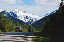
The park is located on the Trans-Canada Highway (Route 1) between Golden and Revelstoke To 171 km to the east of Salmon Arm and 239 km West of Canmore in Alberta. It is in fact the only access road to the park. Calgary is located approximately 4 hrs road to the east and Kamloops3 hrs West.
The Trans-Canada Highway through the park via Rogers Pass may be temporarily closed from December to May, typically for two hours or less, to perform controlled avalanches.
Circulate
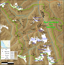
The park is crossed by the Trans-Canada Highway which goes through Rogers Pass. The crossing between Golden and Revelstoke either side of the park can be covered in two hours, but then you will miss all the attractions of the park.
To see

- 1 Rogers Pass
 the summit is open to the public from the spring melt, usually around the end of June. – Mountain pass and Canadian national historic site located in the center of the park. The pass includes a museum and a service area including a gas station.
- Rogers Pass National Historic Site – The historic site is administered by Parks Canada and is visited by more than 430,000 people per year. It extends over a length of 18 km and includes the remains of the railway from Loops Creek to Stoney Creek. It includes among others the remains of the old railway see, its stone bridges, avalanche barriers as well as some remains of buildings dating from the construction of the railway in the pass. It is possible to visit the site for hiking, part of the trails of which follows the old railway tracks, as well as to picnic in one of the five rest stops located in the historic site.
- Rogers Pass Discovery Center (at Rogers Pass),
 1 250-837-7500 From November 19 to April 30, daily, from 7 h To 16 h, but closed from 12 h 30 To 13 h 30 from Tuesday to Friday ; from 1er May to June 9, every day from 9 h To 17 h ; from June 10 to September 15, every day of 8 h To 19 h ; from September 16 to November 18, every day from 9 h To 17 h ; closed on December 25. – Small museum presenting the history of Rogers Pass located in the heart of Rogers Pass National Historic Site. It was awarded the title of best museum of national parks of canada by the magazine Explore. The architecture of the museum is reminiscent of that of an old railway paravalanche. The Discovery Center also serves as an information center for the park and also includes a theater as well as exhibits on avalanches, wildlife and the history of the area. It is the only frontcountry facility that remains open during the winter season.
- Nature observation – Generally speaking, you will increase your chances of spotting animals by walking very early in the morning or late in the day. The best time to observe black bears is from mid-May to early June. You will be able to see mountain goats all year round above the road's avalanche screens on the east side of Rogers Pass. May and June are the best months for bird watching. For the latter, go to the valley of the Beaver River.
Do
In summer
- Mountaineering – The park area is one of the best places in North America for mountaineering. It offers different difficulty levels of rock climbing, snowy and icy sections, but above all a lot of choices for intermediate mountaineers. Good mountaineering spots in the park are the Bostock and Bonney Groups, the Van Horne, Purity and Dawson Ranges as well as the formidable Sir Donald Ranges. In fact, Glacier National Park is recognized as the birthplace of mountaineering in North America. There is a voluntary registration service offered at the Col-Rogers center.
- Cycling , 1 250-837-7500, e-mail : [email protected] – Cycling is a special way to discover the park, even for inexperienced cyclists. Cyclists permitted on the lower section of the Beaver Valley Trail from the trailhead near the Beaver Valley Gravel Pit to the Grizzly Creek Bridge. Cycling is prohibited on the Beaver Valley Trail and on the Copperstain Trail beyond Grizzly Creek. Cycling is also prohibited on the Mont Bald hiking trail and in the Copperstain valley, downstream from the Copperstain pass.
- Peach
 9,8 $ C by daily permit or 34,3 $ C by annual permit. – The national park fishing license is compulsory.
 - Potholing – In the Namiku Caves located between the lower and upper parts of the Cougar Valley in the Selkirk Range west of Rogers Pass. The network of caves totals a length of 5,9 km formed by numerous corridors and caves. To access it, you have to plan a step of 3 to 4 h from the highway on a path that climbs and crosses a mountain corridor before entering the upper part of the valley; amount to more than 800 m altitude before descending, then ascending. Groups of cavers usually camp at Col Balu from where they can descend into the Cougar Valley, explore the caves, and then return to camp on the same day. Only groups that hold a caving permit are allowed to camp at Col Balu. You can join an organized commercial excursion or apply for your own permit for a given date by contacting the Parks Canada office in Revelstoke. Note that in addition to this permit, you must also have a right of access to the park and, if you plan to camp at Bahu Pass, a permit to access the hinterland.
Hiking
The park is traversed by approximately 130 km of hiking trails, some of which have more than 1 000 m of height difference. The trails are open as soon as the snowpack allows it, that is to say from mid-June for the front-country trails and between mid-July to the end of July for those of the 'countryside. All the trails remain open until the first snowfall of the autonomous, that is to say, generally, until mid-October. Note that some trails may remain closed longer if there is the presence of bears or if the snow has damaged boardwalks. At higher elevations, above the tree line, the trails can be blocked by snow until July.
- Trail condition report – Maintained up to date by the park administration.
| Last name | Level | Length (round trip) | Walking time | Drop | Beginning of the trail | Geographical coordinates from the start of the trail | Description |
|---|---|---|---|---|---|---|---|
| Short hikes | |||||||
| Hemlock grove | Easy | 350 m | 15 mins | Minimal | Interpretive walk through an old cedar and hemlock forest in a rain-fed valley. Accessible by wheelchair, by the visually impaired and people with reduced mobility, including seniors and babies in strollers, since there are no obstacles. | ||
| Rock garden | Easy | 428 m | 30 mins | Minimal | Interpretive trail crossing fields of rocks covered with moss and lichen dating from the last ice age. The trail passes through black bear and grizzly bear habitat and climbs to a point where you can see glaciers and the Rogers Pass mountain barrier. It has rock stairs. There are slippery and steep sections so good shoes are needed even if the level is easy. | ||
| Loop Creek | Easy | 1,7 km | 45 mins | 42 m | At the belvedere located east of the Loop stream campsite | Interpretive trail following an old railway line and relating the history of the railway. There you will see the stone pillars which supported the way on the other side of the valley. These works are among the remains of the oldest construction of theWestern Canada. There are short, steep sections. | |
| Meeting of the Waters | Easy | 1,3 km | 30 mins | Minimal | Campsite Illecillewaet | 51 ° 15 ′ 49 ″ N117 ° 29 ′ 31 ″ W / 51.26361, -117.49194 | Walk in the forest near the confluence of the Asulkan and the Illecillewaet. |
| 1885 | Easy | 7,2 km | 2 h | From 1190 to 1 250 m (gentle slope) | Illecilleweat Campground and Loop Creek Campground | Interpretive trail along the original Canadian Pacific Railway. Subject to flooding at the start of the season. | |
| Abandoned tracks | Easy | 2,8 km | 1 h | Minimal | Interpretive trail along the original Canadian Pacific Railway. Wheelchair accessible. | ||
| Bear Creek Falls | Easy | 1,2 km | 1 h | From 871 to 933 m (62 m) | TO 9 km east of the Rogers Pass Discovery Center (east side of Route 1, no left turn lane for westbound traffic, short paved path to trailhead) | 51 ° 21 ′ 13 ″ N117 ° 26 ′ 07 ″ W / 51.35361, -117.43528 | Short trail that descends steeply to Bear Creek Falls. |
| Marion Lake | Moderate | 4,4 km | 2.5 h | 425 m | Campsite Illecillewaet | 51 ° 15 ′ 29 ″ N117 ° 29 ′ 31 ″ W / 51.25806, -117.49194 | First part of the Crête-Abbott trail. Steep ascent through the forest to Lake Marion. |
| Day hikes | |||||||
| Grand Glacier | Moderate | 6,4 km | 3.5 h | 321 m | Campsite Illecillewaet | 51 ° 15 ′ 49 ″ N117 ° 29 ′ 31 ″ W / 51.26361, -117.49194 | Trail climbing on a rocky slope dominated by the Illecillewaet glacier. |
| Bostock Creek | Moderate | 15,6 km | 7 h | 740 m | TO 4 km east of western park boundary (west side of Route 1, no left turn lanes for eastbound traffic) | 51 ° 13 ′ 50 ″ N117 ° 40 ′ 09 ″ W / 51.2306, -117.66917 | Moderate hike in interior rainforest and subalpine forest. |
| Avalanche ridge | Moderate | 8,2 km | 5 h | 795 m | Campsite Illecilleweat | 51 ° 15 ′ 49 ″ N117 ° 29 ′ 31 ″ W / 51.26361, -117.49194 | Steep path leading to an alpine basin. The ridge overlooks the corridor of the road and the railway line. |
| Balu collar | Moderate | 12,8 km | 4 h | From 1318 to 2 097 m (779 m) | Rogers Pass Discovery Center (west side of Route 1, left turn lane for eastbound traffic) | 51 ° 18 ′ 06 ″ N117 ° 31 ′ 18 ″ W / 51.30167, -117.52167 | Path crossing avalanche corridors to alpine meadows. Splendid views. |
| Asulkan Valley | Moderate | 13,8 km | 6 h | 869 m | Campsite Illecillewaet | 51 ° 15 ′ 49 ″ N117 ° 29 ′ 31 ″ W / 51.26361, -117.49194 | Glaciers, mountains and falls. The path becomes steeper after 4 km. |
| Pres Hermit | Hard | 6,4 km | 4 h | 819 m | TO 1,5 km east of the Rogers Pass Discovery Center on the Trans-Canada Highway | 51 ° 18 ′ 50 ″ N117 ° 30 ′ 46 ″ W / 51.3139, -117.51278 | Rapid ascent to the Hermit alpine meadows which house a designated campsite. |
| Mount Sir Donald | Hard | 10,2 km | 5 h | 1 008 m | Campsite Illecillewaet | 51 ° 15 ′ 49 ″ N117 ° 29 ′ 31 ″ W / 51.26361, -117.49194 | Rigorous climbing route to an alpine basin downstream from the peak. The trail has a risk of rock slide, contact park staff for current condition. |
| Glacier crest | Hard | 11,4 km | 6 h | Of 1 245 m To 2 203 m (rise of 958 m) | Campsite Illecillewaet | 51 ° 15 ′ 49 ″ N117 ° 29 ′ 31 ″ W / 51.26361, -117.49194 | Steep trail leading to a ridge with spectacular panoramic views of the rock and ice of the Columbia Range. It allows you to observe the two sides of the glacier: the giant tongue of Illecillewaet to the east and the irregular walls of the Asulkan glacier to the west. The ridge itself is a ridge chiseled by the glaciers that once descended the valleys on both sides. |
| Perley Rock | Hard | 10,8 km | 6 h | 1 143 m | Campsite Illecillewaet | 51 ° 15 ′ 49 ″ N117 ° 29 ′ 31 ″ W / 51.26361, -117.49194 | Ambitious hike on a steep trail ending at a high vantage point over the Illecilleweat Icefield. The trail climbs moderately until it crosses the Vaux cove. He then begins to climb abruptly in the mountain. After making many switchbacks, the trail ends up on a very steep snowy slope that can be very dangerous to cross. You may have to use an ice ax. If you don't have one, it may be safer to finish your ascent there. The climb ends quickly after this snowy slope. |
| Abbott Ridge | Hard | 13,6 km | 6.5 h | 1 029 m | Campsite Illecillewaet | 51 ° 15 ′ 29 ″ N117 ° 29 ′ 31 ″ W / 51.25806, -117.49194 | Trail crossing alpine tundra to emerge on a narrow ridge. At the start of the season, take the marked shortcut to avoid a steep snow-covered slope. |
| Multi-day hikes | |||||||
| Beaver Valley | Moderate | 42 km (go only) | 3 days | 449 m | Trail crossing vast expanses of old forest. It can be taken to get to the Bald Hills via the Caribou Pass. Wild camping is allowed after 5 km. The 20 Mile sector is home to a designated campground, beyond which the level of difficulty of the trail increases: some sections are overgrown or have been washed away by flooding. | ||
| Bald Hills via Copperstain | Hard | 16 – 40 km | Up to 4 days | Up to 1 130 m | Path leading to the vast alpine meadows of the Bald Hills. There are designated campsites at Col Copperstain, in Sector 20 Mile and at Col Caribou. The path is not marked between the Col-Copperstain campsite and the Col-Caribou campsite. You have to master orientation techniques and have a map and compass with you in case visibility is poor in the Bald Hills. The duration, distance and height difference vary depending on the choice of route. | ||
In winter
- Nordic skiing Mid-November to end of April.
To buy
Eat
Have a drink / Go out
Housing
The park includes three serviced campgrounds offering a total of 95 pitches. Moreover, these campsites are one of the few places in Canada where it is possible to camp in a national historic site. Indeed, they are located right next to the abandoned railway tracks. There is also a hotel of 50 bedrooms installed near the top of Rogers Pass. Nearby towns to find accommodation are Revelstoke and Golden.
Camping
No camping infrastructure in the park is maintained during the winter season. No campground in the park has a connection for recreational vehicles, showers or laundry facilities. There are less than a dozen sites that are large enough to accommodate larger motor homes and fifth-wheel trailers. Pitches are allocated to the three campsites on a first come, first served basis and it is not possible to make a reservation. Pitches are available every day if you arrive early. With the exception of long weekends, if you arrive mid-afternoon you will usually be able to get the location of your choice. If you arrive in the evening and the Illicillewaet and Ruisseau-Loop campsites are already full, the Mont-Sir-Donald campground offers pitches almost every day during the summer season. The departure time is set at 12 h for all campsites. The rates for the campsite do not include the entrance fees to the park.
The use of a generator is only permitted 10 h To 20 h. Some sites have a fireplace. Campfires are only permitted at these locations and a campfire permit must be obtained when registering for the campsite. Campfires are prohibited at the Mont-Sir-Donald campsite, but it is cheaper. The wood must be taken from the central wood sheds where the wood is already split and ready to be used. This is free, but you only need to take one load per camping night. You do not need to bring your own wood.
- Illecilleweat campsite (Illecilleweat Campground) (To 3 km west of the summit of Rogers Pass) End of June to end of September. 21,5 $ C by night. – The largest campground in the park with 60 pitches. The site includes flush toilets, log kitchen shelters, food lockers, firewood and potable water. It also includes a reception station with staff. On your arrival, choose the location you want and then go to register at the reception desk in the 30 minutes following your arrival.
- Ruisseau-Loop campsite (Loop Brook Campground) (To 5 km west of the summit of Rogers Pass) from Canada Day to Labor Day. 21,5 $ C by night. – 20 pitches. The site includes flush toilets, log kitchen shelters, food lockers, firewood and potable water. The staff of the Illecillewaet campsite makes a visit in the early evening for the registration of campers. You must register for a self-registration position within 30 minutes following your arrival.
- Mont-Sir-Donald Campground (Sir Donald Campground) (To 1 km west of the Ruisseau-Loop campsite) July and August. 15,7 $ C. – 15 pitches in its natural state. Campfires are not permitted there. The staff of the Illecillewaet campsite makes a visit in the early evening for the registration of campers. You must register for a self-registration position within 30 minutes following your arrival.
- Wild camping 9,8 $ C per person per night or 68,7 $ C per person for the season. – Five locations are designated for backcountry camping. The club Parks and the Alpine maintains four alpine huts and cabins for backcountry hikers: Wheeler Hut, the oldest and largest, located near Illecillewaet Campground, Asulka Hut located in 2 100 m from the Asulkan Pass, the Sapphire Pass Hut, a basic hut located near the Dome, and the Glacier Circle Cabin located in the Beaver River Valley. The latter serves as a base for traveling to the southern parts of the park. It is forbidden to light open fires in the hinterland. Backcountry campers and users of certain shelters must obtain a backcountry access permit available at the Rogers Pass Discovery Center and the Revelstoke Pars Office. Note that in certain circumstances, it is allowed to go wild camping outside the designated sites, check with Parks Canada staff at a visitor center.
- Winter camping
Respect
In nature, there is a golden rule: leave all places as you find them or in better condition and take all your garbage with you. You can bury human waste in a 15 cm depth at a distance of at least 100 m from any water point, but bring your toilet paper and soiled diapers. You must also bring back any leftover food.
If you are hiking, stay on the trails to avoid damaging them and avoid taking shortcuts. Natural and cultural resources such as rocks, fossils, artifacts, horns, antlers, wildflowers and nests are protected by law and should be left where they are.
Pets must be kept on a leash and they are not allowed in the Balu Pass.
Security
 | Emergency telephone number: All emergency services: 1 877-852-3100Emergency dispatch service. Police :911 Ambulance:911 Firefighter :911 |
Be aware that cell phones are unreliable in the mountains.
Before going on a hike:
- carefully study the trail descriptions and maps
- check the weather forecast and trail conditions
- tell someone where you plan to go, when you plan to return and who to call if you don't return
With regard to safety from wild animals:
- move in a group and make noise
- it is forbidden to feed or touch animals and to approach them
- stay at a minimum of 30 to 50 m most animals and 100 m bears
- carry pepper spray and know how to use it
- keep your pets on a leash at all times
When it comes to avalanches, be aware that they can occur when there is a sufficient accumulation of snow on a slope at a certain angle. So be careful when crossing snowy slopes or in an avalanche corridor.
- Avalanche Canada – Avalanche bulletins, information and training (in English only).
Avalanches are set off as a preventive measure by artillery fire from the Canadian Armed Forces on the slopes near the Trans-Canada Highway. Unexploded ordnance may remain. If you find any, do not touch them or move them. Contact the emergency number opposite or dial 911.
Around
- 1 Mount Revelstoke National Park – Relatively small park adjacent to the town of Revelstoke in the Selkirk Mountains.
- 2 Yoho National Park – Park located in the Rocky Mountains on the western slope of the Continental Divide and adjacent to the National parks of Kootenay and of Banff.