| Trans-Canada Highway ((in)Trans-Canada Highway) | |
| Information | |
| Departure | Victoria (British Columbia) |
|---|---|
| Steps | Winnipeg Montreal |
| Arrival | Saint Jean (Newfoundland and Labrador) |
| Length | 8 030 km |
| Duration | a week on the road |
| Country | |
| Location | |
 47 ° 0 ′ 0 ″ N 90 ° 0 ′ 0 ″ O (Modified GPX file) | |
The Trans-Canada Highway is a route that connects the ten provinces of Canada. In fact, it is a series of provincial roads. It is one of the longest roads in a single country in the world.
Understand
The Trans-Canada Highway spans 8 030 km passing through all the provinces of the country from coast to coast. Thus, it is one of the three longest routes in a single country in the world with the route 1 who goes around theAustralia and the Trans-Siberian route in Russia. Despite the long distances, many Canadians wanting to explore the whole country take this route.
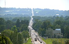
Traveling the entire Trans-Canada Highway means crossing six time zones and over 8 000 km conditions that vary from busy urban highways, including Ottawa and to Montreal, thousands of kilometers away in sparsely populated areas, especially in the Northwestern Ontario or steep mountain ranges, especially in the Rocky mountains. It takes at least about a week at the wheel to cross Canada and that leaves no time to stop en route in the cities or to see the attractions. The full journey includes taking a ferry for a trip of 6 h Between North Sydney in New Scotland and Port-aux-Basques on the island of Newfoundland.
In fact, the Trans-Canada Highway is a series of interconnected provincial highways. In some parts of the country, it has a main axis as well as alternative axes.
It is faster to list the regions of Canada that are not crossed by the Trans-Canada Highway than the reverse. It does not go through:
- the Labrador, the Northern Quebec and the Northern canadian
- the peninsula of Niagara in Ontario
- the south of the New Scotland
In addition, it does not pass through the towns of Toronto in Ontario and of Halifax in New Scotland.
The roads that make up the main axis from west to east are:
- route 1 (in the four provinces ofWestern Canada)
- Highway 17 (in Ontario)
- highways 40, 20 and 85 as well as highways 117 and 185 (at Quebec)
- Highway 2 and Highway 16 (at New Brunswick)
- routes 106, 104 and 105 (in New Scotland)
- route 1 (on thePrince Edward Island and the island of Newfoundland)
The alternative routes of the Trans-Canada Highway are:
- further north in the four provinces ofWestern Canada along route 16 (the yellowhead road)
- further north in Ontario along routes 11 and 71
- further south in Ontario along routes 69, 400, 12 and 7
- further north in Ontario and at Quebec along routes 66 (in Ontario) and 117 (in Quebec)
Steps
There are three ends of the Trans-Canada Highway that can be used as starting points. In the west, it is Victoria and of Prince rupert in British Columbia and, to the east, of Saint Jean To Newfoundland and Labrador. The stages below use the shortest or most direct route, that is, the main axis of the Trans-Canada Highway. In addition, the route is presented from west to east, but it is obviously possible to travel it from east to west.
Victoria to Winnipeg

In the four provinces ofWestern Canada, the Trans-Canada Highway follows Highway 1 in each province. From Victoria in British Columbia, it crosses the majestic Rocky Mountains before going through the large meadows in Alberta, in Saskatchewan and at Manitoba.
In British Columbia and particularly to Vancouver, prices for gasoline are higher than in the other three provinces of theWestern Canada. Prices start to rise again in Ontario.
- 1 Victoria – From there the road heads north on theVancouver Island.
- 2 Nanaimo – It is from there that you have to take the ferry to reach Vancouver on the continent.
- 3 Vancouver – From there, the highway continues east.
- 4 Hope – The route continues north through Fraser Canyon. Note that between Hope and Kamloops, route 5, which corresponds to yellowhead road, is an alternative route that takes an hour less to travel higher in the mountains instead of through the canyon. However, the latter should be avoided in winter. Even though some maps still say this is a toll road, it is no longer the case.
- 5 Cache Creek – From there, the road heads east.
- 6 Kamloops – The route continues east through the Shuswap Lake area known for its beaches and fishing.
- 7 Revelstoke – Small mountain town after which the road crosses Rogers Pass in the Rocky Mountains where there is a high risk of avalanches which is controlled by Parks Canada to arrive in Alberta. Since we are changing time zones, we have to move forward one hour across the provincial border.
- 8 Banff – Important tourist destination ofAlberta located in the banff national park from where the road continues east to enter the Canadian prairies.
- 9 Calgary – The road crosses the city center before continuing east.
- 10 Medicine hat – From where the road continues through the meadows to arrive in Saskatchewan. Since the province of Saskatchewan does not use daylight saving time, in winter it is necessary to advance one hour when entering from Alberta while, in summer, it is more when leaves her to enter the Manitoba that you have to move forward an hour.
- 11 Moose jaw – First major city crossed in Saskatchewan.
- 12 Regina – Capital of the province and last major city before arriving at Manitoba.
- 13 Brandon – First important city in Manitoba.
- 14 Winnipeg – Capital of the province which marks the end of the western part of the Trans-Canada Highway. The road continues east to enter Ontario.
This road (Trans-Canada Highway 1) more or less follows the Canadian Pacific Railway. The alternative Trans-Canada Highway (Trans-Canada Route 16) consists of starting from Prince rupert in British Columbia and follow the yellowhead road (route 16) which passes notably by Edmonton to join the main axis above at Portage-la-Prairie to Manitoba.
Winnipeg to Ottawa

Winnipeg is located at 2 170 km west ofOttawa. The road first crosses meadows before passing through a long expanse of sparsely populated woodland in the Northwestern Ontario.
- 15 Kenora – First major city in Ontario from where the road continues east.
- 16 Dryden – Last city in the Central time zone, after which you have to move forward one hour. The crossing of the time zone line is indicated along the route.
- 17 Thunder bay – First large city encountered in Ontario from where the road continues east following the coast of Lake Superior.
- 18 Wawa – Small town that is legendary among hitchhikers who often find themselves stuck there. In addition, the section between Wawa and Sault-Sainte-Marie is often closed in winter due to bad conditions.
- 19 Sault-Sainte-Marie – Important town located on the border with the United States from where the road continues east.
- 20 Sudbury – Large city from where you have to head south to reach Toronto, but the Trans-Canada Highway continues east.
- 21 North Bay – Important city.
- 22 Pembroke
There are a few alternative branches of the Trans-Canada Highway in this part of the country:
- One from Nipigon to the east of Thunder bay which extends further north along Route 11 and which crosses in particular Hearts, Kapuskasing, Cochrane and Temiskaming Shores before joining the main axis of the Trans-Canada Highway at North Bay.
- One from Sudbury which extends further south following routes 69 and 400. Instead of continuing to get to Toronto, you have to take route 12 which makes the detour and joins up with highway 7 which passes notably by Peterborough and Perth before joining the main axis of the Trans-Canada Highway just west ofOttawa.
- Another alternative route exists from route 11 in Ontario by taking route 66 which becomes route 117 au Quebec. This road extends even further north and joins the main axis of the Trans-Canada Highway at Montreal.
Ottawa to Amherst

- 23 Arnprior – From there the road becomes wider and busier with heavier traffic as one enters the road. Ottawa Valley before arriving at the federal capital.
- 24 Ottawa – From there it is possible to cross to Quebec to go to Gatineau, but the Trans-Canada Highway remains Ontario continuing east along Route 417.
- 25 Embrun – From there, the road begins to head quietly to the northeast.
- 26 Hawkesbury – Last town along the Trans-Canada Highway in Ontario. From there, the Trans-Canada Highway continues to Quebec by following Highway 40. It is recommended to fill up with gasoline in Ontario since gasoline is much more expensive in Quebec.
- 27 Montreal – The Trans-Canada Highway crosses downtown Montreal to pass on the south shore of the St. Lawrence River where it follows Highway 20. Note that it is possible to bypass Montreal by taking Highway 30 from Vaudreuil-Dorion and return to the Trans-Canada Highway on the south shore.
- 28 Drummondville – First major city encountered on the south shore from where the road continues east.
- 29 Levi's – The Trans-Canada Highway does not pass through the city of Quebec which is located on the north shore of the St. Lawrence River. To get there, you have to leave the highway at Sainte-Foy heading north. Note that these are the last east bridges spanning the river. Note that you can also go to Quebec by passing by the north shore of Montreal to Quebec by crossing in particular Three Rivers, but the distance is longer and this road is not part of the Trans-Canada Highway. The latter continues east from Lévis, following the south shore of the river.
- 30 Wolf River – It is from there that the river begins to become a gulf and where you can spot saltwater marine life including whales. At this point, the road splits in two with the Trans-Canada Highway heading south following Highway 185 which has recently been widened in parts to become Highway 85. The other road continues east to join the highway. Gaspé Peninsula, but it is not part of the Trans-Canada Highway.
- 31 Saint-Louis-du-Ha! Ha! – Last major town along the route to the Quebec before entering New Brunswick. When crossing the provincial border, you have to go forward one hour.
- 32 Edmundston – First major town along the route to New Brunswick from where the road continues to head south, roughly following the border with the State of Maine.
- 33 Fredericton – Provincial capital from where the road continues east.
- 34 Moncton – Last major town along the route to the New Brunswick before entering New Scotland.
- 35 Sackville – Small town located on the border between New Brunswick and the New Scotland. It is recommended that you refuel before crossing the provincial border since prices are higher in Nova Scotia. In Nova Scotia, the Trans-Canada Highway follows Highway 104.
- 36 Amherst – First major city encountered in New Scotland.
From Sackville to New Brunswick, an alternative route is to follow route 16 instead of passing by New Scotland which instead crosses the Confederation Bridge, along 9 km, to get toPrince Edward Island. The bridge is free to get to the island, but there is a charge to return to the mainland. On the island, the Trans-Canada Highway follows the south of the province, starting from the west, to reach Charlottetown, the provincial capital located about halfway, before ending at a ferry stopping point in the east of the island. The duration of this trip on the island, without stopping, is approximately 95 minutes.
Moncton to North Sydney


- 37 Springhill – First major city encountered in New Scotland.
- 38 Truro – First large city encountered in New Scotland. The Trans-Canada Highway does not go to Halifax, the capital and the largest city of the province. To get there, take Route 102 south from Truro.
- 39 New Glasgow – Small town.
- 40 Antigonish – Important city.
- 41 Port Hawkesbury – From there it is possible to take routes 4 and 104 to reach theCape Breton Island north of the mainland of the province. For its part, the Trans-Canada Highway continues along Highway 105 to the west.
- 42 Baddeck – Small town.
- 43 North Sydney – End of Highway 105 and east end of the Trans-Canada Highway on the mainland. From there, you have to take a ferry to get to the island of Newfoundland. The hard crossing 6 h and advance reservations are recommended with Marine Atlantic.
Port-aux-Basques to Saint-Jean


TO Newfoundland and Labrador, the Trans-Canada Highway follows Highway 1 and crosses the island from west to east.
- Port-aux-Basques – Arrival of the Marine Atlantic ferry and start of the Trans-Canada Highway on the island of Newfoundland in the west of the island from where the road heads east.
- 44 Corner brook – The largest city in theWestern Newfoundland.
- 45 Deer lake – Small town.
- 46 Grand Falls-Windsor – Big city.
- 47 Gander – Small town with a large international airport. From there the road heads southeast to enter the Avalon Peninsula.
- 48 Saint Jean – Capital of the province and east end of the Trans-Canada Highway. An interesting draw to end a trip along the Trans-Canada Highway is Signal Hill.
To go
The two ends of the main axis of the Trans-Canada Highway are Victoria to the west and St. John's Newfoundland to the East. Another starting point to the west is Prince rupert. The eastern end of the continent corresponds to the city of North Sydney in New Scotland. Consult the pages of these cities to find out how to get there.
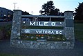
Monument corresponding to the "mile zero" of the Trans-Canada Highway at Victoria in British Columbia

The “one thousand and one” center located at the end of the Trans-Canada Highway at St. John's Newfoundland


Security
You need a reliable vehicle. A complete mechanical inspection before departure is advised. A cell phone can be useful as a means of obtaining roadside assistance, but in many sparsely populated areas (especially on the shores of Lake Superior) the signal is lost; coverage is also very sporadic in the Rockies of British Columbia.