| Grand Canyon National Park Grand Canyon National Park | |
.jpg/250px-Grand_Canyon_(26374424110).jpg) | |
Location  | |
| Area type | National Park |
|---|---|
| State | United States of America |
| Region | Arizona |
| Surface | 4,927 km² |
| Foundation year | 1919 |
| Institutional website | |
Grand Canyon National Park is a protected area located in the United States of America, in Arizona.
To know
It is one of the first national parks in the United States of America. Inside is the Grand Canyon, a gorge of the Colorado River, considered one of the natural wonders of the world. L'UNESCO has included the park among the World Heritage Sites. The Grand Canyon is extremely wild and remote, although many places are accessible via footpaths and bridleways.
Geographical notes
The main public areas of the park are the north and south rims of the Grand Canyon itself. The rest of the park is extremely rugged and remote, although many places are accessible by footpaths and back roads.
North Rim
The North Rim is a smaller, more remote area with less tourist activity. It is accessed from Arizona State Route 67.
South Rim
The South Rim is more accessible than the North Rim; most park visitors arrive at the South Rim, arriving on the Arizona State Route 64. The highway enters the park through the south entrance, near Tusayan, Arizona, and heads east, leaving the park through the east entrance. L'Interstate 40 provides access to the area from the south. From the north, the US Route 89 colleague Utah, Colorado and the North Rim to the South Rim. Altogether, about 30 miles of the South Rim are accessible by road.
Flora and fauna
Do not feed the animalsThe most famous animal is the condor of California; also swallows, hummingbirds and the crow. Deer, mule, North American moose and coyote are also found.
Feeding squirrels is prohibited and very discouraged by heavy fines.
When to go
Temperatures and weather inside the park vary greatly by location. Temperatures on the North Rim are often 11-16 ° C cooler than on the river. It can be cool and comfortable in early summer, as temperatures on the river rise above 49 ° C. It is not uncommon for local canyon guides to encounter novice hikers in desperate shape. Some die. An unusual number of deaths occur among young people who overestimate their abilities. Due to the high altitude, snowfalls regularly occur during the winter months. July and August are monsoon season in Arizona and severe thunderstorms can sweep away quickly with lightning every few minutes and sudden showers. people are struck by lightning quite regularly, so take shelter indoors during storms.
Bring a reasonable amount of water with you to suffer less from the heat.

How to get
By plane
_AN1530463.jpg/220px-Grand_Canyon_-_Grand_Canyon_National_Park_(GCN_-_KGCN)_AN1530463.jpg)

- 1 Grand Canyon National Park Airport.
- Airport of Las Vegas.
- Airport of Phoenix.
- Airport of Flagstaff.
By car
South Rim is located 60 miles north of Williams. It can be reached via the Route 64 via the Interstate 40, or from Flagstaff through the Route 180.
On the train
From the station of Williams there Grand Canyon railway in about 2.30 hours it takes you directly to the train station Grand Canyon Railway Depot, along the South Rim.
By bus
There are no commercial bus lines offering transportation. Several tour companies offer guided tours originating from Flagstaff, Phoenix, Las Vegas, Los Angeles and other locations, directly on the South Rim ' and some offer tours that include a visit to the North Rim. There is a small shuttle service, Arizona Shuttle Service, which transports passengers and luggage from Flagstaff Amtrak Station. Tickets for this shuttle can also be purchased from Amtrak.
Permits / Rates
.jpg/220px-Grand_Canyon_National_Park_Visitor_Center_3975_(7117366433).jpg)

Entrance fee 25 $ per vehicle.
The park headquarters are located at Grand Canyon Village, not far from the south entrance of the park, near one of the most popular viewpoints. The Grand Canyon Village is located at the north end of the US Route 180, from Flagstaff. It is a full-service community, which includes housing, fuel, food, souvenirs, a hospital, churches, and access to walking trails and guided walks and conferences.
How to get around
Several viewpoints in the park have limited parking and must be reached using the park's shuttle system. The National Park Service operates an extensive shuttle service on the South Rim with three interdependent routes. The service is free and generally runs from before sunrise until after sunset, depending on the itinerary. The service is more frequent from May to September and includes additional routes.
What see

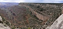
 1 Grand Canyon. It is an immense gorge created by the Colorado River in northern Arizona. It is approximately 446 kilometers long, up to 1,857 meters deep and with a width ranging from 500 meters to 29 kilometers. For the most part it is included in the Grand Canyon National Park. Its great depth and in particular the height of its layers (most of which formed below sea level) can be attributed to the 1500-3000 meter rise of the Colorado plate, which began about 65 million years ago. This rise has accentuated the height difference of the Colorado River and its tributaries, resulting in an increase in the speed of the waters and therefore in their capacity for erosion of the rocks.
- 2 Boardwalk over the Grand Canyon (Grand Canyon Skywalk), Peach Springs, AZ 86434 (Outside the territory protected by the National Park Service. It is accessed via the terminal of the Grand Canyon West Airport or driving for about 190 km from Las Vegas or from the south (from Kingman) through the Highway 93.), ☎ 1 888 8689378.
 Legacy Gold Package: $ 81, various attractions including the Grand Canyon Skywalk. Operated by the Hualapai Tribe, it is a transparent paved horseshoe-shaped elevated walkway located near the Colorado River, atop a side canyon in the Western Grand Canyon area. The vertical height below the transparent walkway varies between 150 and 240 meters. The overall width of the Skywalk is 20 meters and extends out of the canyon rim for 21 meters. Personal cameras and video cameras are not allowed on the Skywalk, but must be deposited in special lockers at the entrance
What to do
| ATTENTION: Some of the contents shown could generate dangerous situations or damage. The information is for illustrative purposes only, not exhortative or didactic. Use of Wikivoyage is at your own risk: read the warnings. | |


- 1 Bright Angel Trail (Dangers hikers may encounter along the Bright Angel Trail include dehydration, sudden downpours, flash floods, unstable terrain, rockfall, wildlife encounters, and extreme heat. Additionally, the trail is used by mules carrying people and gear to and from the canyon floor. Although these mules are highly trained, the track is narrow in places and care must be taken to give the mules the right of way. The track also has many hairpin bends and a bad fall can cause serious injuries. Squirrel bites are the leading cause of animal injury to park visitors.). It is a steep 9-mile walk in Grand Canyon National Park. Ancient Indian track (there are Indian pictographs), it is one of the most famous walking routes in the world. The route begins on the south side of the Grand Canyon and descends 1,335m to the Colorado River. Here the path takes the name of River Trail and continues along the river for another 3 km until Bright Angel Campground and al Phantom Ranch.
- Grand Canyon helicopter tour (departures from Las Vegas). starting at $ 300.
Shopping
Where to eat
Where stay
Inside the park there are 7 hotels, and other hotels and motels can be found in the nearby Tusayan. Numerous accommodations are available along the South Rim. There are also some sites to practice camping in a tent or in a camper.
Safety
How to keep in touch
Around
Other projects
 Wikipedia contains an entry concerning Grand Canyon National Park
 Commons contains images or other files on Grand Canyon National Park