| Jigme Singye Wangchuck National Park | |
 | |
Location 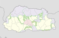 | |
| Area type | National Park |
|---|---|
| State | Bhutan |
| Surface | 1,730 km² |
| Foundation year | 1995 |
| Institutional website | |
Jigme Singye Wangchuck National Park (formerly Black Mountains National Park) is a protected area located in Central Bhutan.
To know
Geographical notes
Jigme Singye Wangchuck National Park is the most central of Bhutan's national parks and occupies most of the district of Trongsa, as well as parts of: Sarpang, Tsirang, Wangdue Phodrang and districts of Zhemgang.
The park is bordered to the east by the Mangde Chhu River and the Sankosh-Punatsangchu River Basin to the west. Jigme Singye Wangchuck adjoins the Royal Manas National Park to the southeast.
The high mountains in the central regions of the national park are an important watershed for the streams and rivers that become the headwaters and tributaries of the Mangde Chhu River to the west. Nika Cchu joins Mangde Chhu from the north.
Flora and fauna
This park is home to virgin forests and a range of wildlife, including leopards, red pandas, black bears of theHimalaya and many bird species and represents the best example of the Mid-Himalayan ecosystems of the Eastern Himalayas which contain diverse ecological biomes ranging from subtropical forests at its lowest elevations to alpine meadows at its highest elevations. It is the only park that contains an old forest of Himalayan pine. The park is also vital for various migratory fauna species, particularly migratory birds due to its wide range of altitude and vegetation, and central location in the country. It covers a wide range of habitat types from the permanent ice on top of Durshingla (in Black Mountains), alpine lakes and pastures, through coniferous and deciduous forests to temper subtropical forests and forests. The park protects the largest and most biodiverse temperate forest area in the wholeHimalaya.
The habitats of the Eastern Himalayan deciduous forest ecoregion are protected within the park
When to go
The wide range of altitudes and mountainous terrain create complex climatic conditions, from humid subtropics in the south to cool temperate ones in the high altitude areas in the north. The southwest monsoon from June to September contributes most of the annual rainfall. The rain shadows imposed by the high mountain ranges result in localized precipitation gradients during this period.
How to get
By car
Along the border of the park, from north to south-east, run the main highways of Bhutan. It is also connected via biological corridors to other national parks in Bhutan.