| Pass of the Shepherds | ||
 | ||
| State | Italy | |
|---|---|---|
| Region | Tuscany | |
| Altitude | 166 m a.s.l. | |
| Inhabitants | 360 (2001) | |
| Prefix tel | 39 055 | |
| POSTAL CODE | 50020 | |
| Time zone | UTC 1 | |
| Patron | St. Joseph | |
Position
| ||

Pass of the Shepherds is a fraction of the municipality of Greve in Chianti in the province of Florence.
To know
Despite the name, the pass is not located on top of a mountain, but in the valley floor near the river Greve in the homonymous valley. The main roads have undergone a change over the centuries and the one that once united the Maremma to the Casentino passed right through there. From the Val di Pesa up to the villages of Vignano, Luciana and Tolano to the Passo dei Pecorai and then again to Chiocchio, Mugnana and the pass of La Panca, at the lowest point crossing the hills that divide the valleys of the respective rivers. In some more unused points of the old road, there is still the Etruscan pavement with large flat stones.
Background
For many years the most favorable way to feed animals was to take them to suitable pastures. A good pasture not only determines the sustenance of the individual animals but positively influences the quality of the meat, fleece and milk produced. The shepherds therefore moved from Maremma, excellent in winter because it is fresh and never frozen, until Casentino, where in the summer there were large expanses of green pastures. The Passo dei Pecorai was also optimal because almost halfway it also had a river Greve which in the mid-seasons, however, had an important and sufficient water flow to nourish and wash the millions of animals that passed through it. The complete route included 13-14 stages to be carried out twice a year.
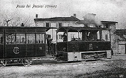
The town square was often used as a meeting and gathering point for the district, typical events of the time were represented here such as the "bruscello"and the agricultural goods were loaded on the wagons as long as the transhumance and tramway of the Chianti they were no longer practiced and profitable. The railway, which has become a road, is the main communication route from Chianti to Florence. On the facade of the main building there is still one of the oldest geographical points of the town (around 1870).
How to orient yourself
How to get
By plane
- 1 Florence-Peretola Airport (Amerigo Vespucci Airport, IATA: FLR). About 27 km away, it is certainly the most convenient airport for those who have to take this means to get closer. Once you leave the airport, you can take a taxi to go to your destination or to the most convenient and cheapest public transport. There are also scooter and car rental services.


By car
The A1 motorway is the main artery that connects Greve to the rest ofItaly. Since there is no dedicated exit, for those coming from the south it is preferable to exit at "Incisa Valdarno" continuing in the direction Figline Valdarno and from there follow signs for Greve in Chianti. Those coming from the north, on the other hand, should go out at "Firenze sud" and then take the SR 222 (Chiantigiana) towards Greve in Chianti.
On the train
There are no railway stations in the municipality of Greve In Chianti. The closest railway stations are those of: Engraved in Val D'arno, Figline Valdarno, Rovezzano, Vicchio is San Piero a Sieve. Once you arrive at these stations you need to take other means of transport (taxi or bus) to get to your destination.
From the station of Florence Santa Maria Novella it is possible to take a bus at the opposite terminus.
By bus
The most convenient way to reach Greve is by interurban buses of the acvbus.
How to get around
What see
Events and parties
What to do
Shopping
How to have fun
Where to eat
Where stay
Safety
How to keep in touch
Around
Other projects
 Wikipedia contains an entry concerning Pass of the Shepherds