The Pegnitz cycle path in Bayreuth and leads via the city of Pegnitz to Neuhaus an der Pegnitz. From Neuhaus the cycle path is called Pegniz Valley Cycle Path designated and officially leads to Hohenstadt. However, it is advisable to drive to Hersbruck.
Route profile

Length: approx. 82 km
Signposting: Well
Slopes: There are some challenging inclines between Bayreuth and Pegnitz
Path condition: very different, from paved over gravel forest paths to beaten paths
Traffic load: low
Suitable bike: each
Family suitability: Yes
Inline suitability partially
background
preparation
The usual preparation for a bike tour is sufficient; no special measures are necessary for this route.
getting there
By train
The bike path is in the area of the VGN (Transport association for the greater Nuremberg area). It's easy to get here by train. The railway line between Bayreuth and Nuremberg runs through the Pegnitz Valley, so you can comfortably get on or off the entire bike tour.
Of Nuremberg Regional trains depart every hour. There are train stations in Bayreuth, Creußen, Pegnitz, Neuhaus a. d. Pegnitz, Velden, Rupprechtstegen, Vorra, Hohenstadt
In the street
Highway ![]() Berlin - Munich, various exits from Bayreuth to Hersbruck.
Berlin - Munich, various exits from Bayreuth to Hersbruck.
Route description with sights
0 km - from 1 Bayreuth Central Station just follow the signs Bayreuth consequences.
Oberkonnersreuth with the beer garden 1 Storchenkeller under old linden trees.

The Storchenkeller

Of 1 Wolfsbach the path always remains close to federal highway 2 and is signposted as the Pegnitz cycle path.
- The scenic route leads over the Rotmainquelle.
- 1 Destuben
- 2 Unterschreez
- 3 Hague
- 1 Source of the Red Main
- The log cabin of the 2 Brewery & Landgasthof Kurzdörfer invites you to stop. Then on to Schnabelwaid back to the main route.

The source of the Red Main

In 2 Neuenreuth on the federal road over the railway bridge. 15.5 km - 3 Cussen with medieval town center and Krügemuseum and 2 railway station
In 4 Beak woad the variant comes back to the main route via the Rotmainquelle. There is one here 3 Railway station.
Continue over 5 Zips to 6 Buchau with the Church of St. Matthias and Anna.

St. Matthias and Anna in Buchau

33 km - Am 4 Pegnitz railway station over, to the center of Pegnitz and via Nürnberger Straße out of town 7 Nemschenreuth
In Horlach drives directly 1 Gasthaus Peter and 3 Gasthaus war with overnight accommodation over.
Now it's off to the Veldenstein Forest. First you come across the imposing Lochstein, then the path leads to the left. Continue on gravel paths through the forest, past fish ponds and abandoned settlements. You drive along a fence, the most important drinking water extraction area in the city of Nuremberg.
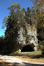
The perforated stone

8 Ranna is a district of the city Auerbach in the Upper Palatinate
50 km - In Neuhaus an der Pegnitz the Pegnitz Valley Cycle Path connects to the Pegnitz Cycle Path. The way goes on 5 Train station past. The place offers a castle, a rococo church with a 450 year old Madonna and three comma restaurants. The commune managers are not always open, only one of the three pours alternately, the traditional six-pointed brewing star hanging on the house is the distinguishing mark.
Over a narrow wooden bridge it goes over the Pegnitz am 2 Landgasthof - Pension "Zur-Linde" in the Finstermühle district
railway station 6 in Velden (Pegnitz)
7 Rupprechtstegen station
Artelshofen
The bike path leads directly to the 8 Train station in Supply past.
Eschenbach
Hohenstadt connection to the Five rivers cycle route. 9 Hohenstadt station
In Hersbruck there are two train stations 10 Hersbruck train station (l Pegnitz) and 11 Hersbruck train station (r Pegnitz)which is the right one for the return trip to Bayreuth.
security
The cycle path is largely free of traffic, special attention is required when crossing roads and bends should be driven on the right-hand side to avoid collisions. It should definitely be ridden with a bicycle helmet.
trips
References to literature and maps
- Fritsch hiking maps 1: 50,000, No. 65 - Franconian Switzerland Nature Park, North sheet
Web links
- Bike travel wiki - from Hohenstadt to Bayreuth
- Bavarian network for cyclists - from Bayreuth to Neuhaus an der Pegnitz