
Poddębicki district - poviat in Poland in the north-west part of the Lodz voivodeship, created in 1999 as part of an administrative reform. Its seat is in the city Poddębice inhabited by 18.6% of the total population of the poviat.
The Poddębicki District already existed years ago - it was established on January 1, 1956 in the Łódź Voivodeship and the present district has almost the same borders.


The poviat covers the area of 881 km², which is 5% of the area of the Lodzkie Voivodship and is inhabited by 41,962 inhabitants, which is 1.66% of the entire voivodeship population and gives a population density of 47.63 people / km².
In the northern part of the poviat, there is the A2 motorway and the national road runs across it Konin – Łódź – Rawa Mazowiecka.
The poviat is made up of two urban-rural communes (Poddębice i Uniejów) and four rural communes (Daliks, Pęczniew, Wartkowice and Rock it).
Data on the poviat's population according to the Central Statistical Office statistics as of June 30, 2012 are as follows:
The entire Poddębicki district: 41,962 20,731 21,231; 10 803 5 079 5 724; 31 159 15 652 15 507
gm.w. Dalików 3 850 1 963 1 887; - - -; 3850 1963 1887
gm.w. Pęczniew 3545 1763 1782; - - -; 3545 1763 1782
gm. m – w. Poddębice 15 884 7 703 8 181; 7 794 3 679 4 115; 8 090 4 024 4066
gm. m – w. Uniejów 7,219 3,543 3,676; 3 009 1 400 1 609 4 210 2 143 2 067
gm.w. Wartkowice 6 324 3 144 3 180; - - -; 6 324 3 144 3 180
gm.w. Call 5 140 2 615 2 525; - - -; 5 140 2 615 2 525
The above numbers mean: total, men, women; cities in general men, women; all villages: men and women.
The area of the poviat covers the southern part of the Kolska Valley, Wysoczyzna Łaska and the edge of the Sieradzka Valley.
The main rivers are Guardwhich to a large extent cover the western border of the poviat and its right tributary Ner.
The landscape is dominated by plains and postglacial formations in the form of small inselberg hills.
The retention reservoir is the largest reservoir in the poviat Jeziorsko on the Warta River.
There are 16,000 ha of forests in the poviat.
The great natural advantage is the geothermal water resources, exploited in Poddębice, but mainly in Uniejów, where a complex of thermal pools has been built and the town has the status of a health resort.
The area of the poviat is the border of two ethnographic subregions: Sieradz and Łęczyca.
There are many historic buildings and tourist attractions in the district, incl.
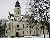
- Renaissance palace from the 17th century in Poddębice,
- The parish church of st. Catherine in Poddębice,
- Wooden mansion in Tumusin,
- Church of st. Michael the Archangel in Niemysłów,
- Castle in Uniejów - 14th century gothic building erected in the years 1360 - 1365,
- Collegiate Church Assumption of the Blessed Virgin Mary in Uniejów, funded by Archbishop Bogoria Skotnicki in 1349,
- The wooden parish church of st. Nicholas in Wierzchy, commune Dzhim - the current one, erected in 1727, restored in 1785 and 1966.
- The hiking trail of Maria Konopnicka running from Poddębice to Bronów - the writer's place of residence.
About 350 km of tourist routes run through the district, both local (e.g. Maria Konopnicka, Kazimierz Deka-Deczyński, Po Ziemia Uniejowskiej), regional (e.g. Hot Springs, the Major Henryk Dobrzański "Hubal" horse trail) and international (Łódzka Magistrala Rowerowa, which is part of the route from Łódź to Berlin being created), water, walking, cycling or horse riding.
Knights tournaments and rallies of the Polish Movement of Indian Friends in Uniejów take place here.
County website: http://www.poddebicki.pl/