| Pramanta Πράμαντα | ||
 | ||
| State | Greece | |
|---|---|---|
| Region | Epirus | |
| Territory | Ioannina | |
| Altitude | 828 m a.s.l. | |
| Inhabitants | 1.137 ((2011 census) | |
| Time zone | UTC 2 | |
Position
| ||

Pramanta it is a village Greek ofEpirus, located in the Ioannina region.
To know
The village of Pramanta is located on the north side of the 1 mount Strongoula (Στρογγούλα) one of the highest peaks of the Athamanikà chain (Αθαμανικά) which separates theEpirus from Thessaly.
How to orient yourself
Three streams cross the Pramanta territory dividing it into five districts (Danubio, Kommatakia, Tsiopela, Fraxoi and Agia Triada). The Pramanta hotels listed below are concentrated in the Tsiopela district.
How to get
By car
From Igoumenitsa follow via Egnazia up to2 exit 5 and then take the provincial road Ioannina-Arta
By bus
- The buses of the regional consortium KTEL of Giannina from the capital of Epirus to the city of Arta they make stops on the provincial road.
How to get around
What see

Kipina Monastery
Plaka bridge
- 1 Kipina Monastery (Μονή Κηπίνας, Monì Kipinas). A small monastery carved into a recess in a rock face that falls perpendicular to a ravine.

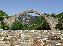
- 2 Plaka bridge (Γεφύρι της Πλάκας, Yefìri tis Plakas). The Plaka Bridge is a stone bridge with an arch 40 meters wide and about 20 meters high.
- 3 Anemotripa cave (Σπήλαιο Ανεμότρυπα, Spìleo Anemotrìpa) (5 km southwest of Pramanta), ☎ 30 2659062300.
 Mon-Sun 10: 00-17: 00. Anemotripa (literally: the hole of the winds) is one of the most beautiful caves in Greece, discovered in 1960.
- A "capricious" underground river has changed its course several times, creating a dozen ravines with waterfalls and miniature lakes of different colors and baptized with particular names: Megali Sala (Great Hall), Kataraktis (Waterfall), Griza Limnoula (Gray pond), Diadromos tou Ploutou is Thalamos tis kokkinis limnis (Hall of the red lake).
Events and parties
What to do
_-_panoramio.jpg/220px-Rafting_in_Arachthos_river)_-_panoramio.jpg)
Rafting on the Arachtos River
- Rafting. Rafting expeditions are organized in the section of the Arachtos River between the Politsa and Plaka bridges. 10 km long, it is perhaps the most beautiful stretch of Arachtos to explore as it stops at waterfalls not visible from the road. It is an easy route to tackle but only in August when the river is almost dry.
Shopping
How to have fun
Where to eat
Where stay
Moderate prices
- 1 Pramanta Alpine Refuge. The refuge is located at an altitude of 1300 m., Near the summit of Mount Strongula and can be reached on foot or via a sturdy off-road vehicle by taking a path that branches off from the road to Melissouryì, shortly after passing the Orizontes hotel. The shelter consists of dormitories with shared bathrooms. Towels and bathroom accessories, blankets, sheets and pillows are provided free of charge.
- Right next to the refuge there is a space where you can camp. Not far away is the Katsantoni cave. Above the village of Melissouryì there is another refuge.
Average prices
- 2 Hotel Xenion tou Georgiou Merantza, Contrada Tsopela. The Xenion hotel offers its guests rooms with private bathroom and kitchenette. Wi-Fi is free. It also has a solarium, outdoor swimming pool and restaurant service.
- 3 Orizontes Tzoumerkon, Contrada Tsopela (On the provincial road to the town of Melissourgoi), ☎ 30 2659 061002. Rustic style hotel with breathtaking mountain views. Free WIFI.
- 4 . Contrada Tsopela. Traditional stone hotel with modern standards.