| Green walk | |
.JPG/210px-20120815_Zonienwoud_(37).JPG) | |
| In the forest of Soignes | |
| Information | |
| Departure | Cycling and walking circuit |
|---|---|
| Steps | The Forêt de Soignes and the south of Uccle. The Woluwe valley. Between Senne and Woluwe. The Heyzel plateau, the royal parks. Molenbeek Valley. Pajottenland. Between Vogelzangbeek and Geleytsbeek. |
| Length | 61,03 km |
| Altitude | Between 16 and145 m |
| Duration | 4 h 35 (by bike at an average speed of 14 km / h) |
| Country | |
| Region | Brussels-Capital |
| Tourist information office | Rue Royale 2 1000 Brussels. E-mail: [email protected] |
| Location | |
 50 ° 50 ′ 48 ″ N 4 ° 21 ′ 9 ″ E (Modified GPX file) | |
| Official site | |
| Touristic site | |
The Green walk is a walk for pedestrians and cyclists of more than 60 kilometers which goes around the Brussels-Capital Region passing through various natural points of interest such as parks, marshes, protected natural areas, country landscapes but also picturesque industrial areas.
Understand

Created and managed by the Brussels Institute for the Management of the Environment (IBGE), this landscaped route connects the natural, semi-natural green spaces and the developed parks of the second ring of Brussels included in the Natura 2000 network of theEuropean Union and allows you to make a complete tour of the Region without leaving a secure and marked route. The first section was inaugurated in 2007 and the entire route was upgraded in 2009. Some sections are designed to facilitate the movement of people with reduced mobility and others are in progress.
The route, if we stick strictly to following the marked route without going deeper into the visit of the areas encountered, is long 61,03 km and the altitude varies between 1 16 meters and 2 145 meters away . It is divided into seven long sections of 6,3 km To 10,3 km which can be traveled in one direction or the other and with, in certain places, a duplication in order to allow an easy passage of pedestrians and cyclists or to prevent the latter from circulating in too fragile sites.
The network Wireless is accessible all along the route for a fee.
Route details
- The green promenade (48) – Guide to the green promenade edited by theIBGE
Markup
The main markings consist of dark green panels with a light green pictogram and, in the upper right corner, the numbers “01”. Other figures can also be entered and indicate that a section of a local promenade is common to that of the green promenade.
These signs, sometimes affixed on posts specific to the green promenade and sometimes on road sign posts, are accompanied by a sign indicating the direction recommended but not compulsory.
This signaling is supplemented by staking posts confirming or reminding the direction to take and by posts indicating the direction to take to reach other sites or public transport nodes located nearby.
Finally, the system is enriched by information panels offering a general map and a detailed map of the Brussels Region, but also a text whose theme depends on the natural site where the information panel is installed.
Be careful not to confuse the markings of the green promenade with that of the local walks whose pictograms are identical but orange in color.
Main markup
| Pictogram | Meaning |
|---|---|
 | Route designed for cyclists and pedestrians. |
 | Route designed for cyclists, pedestrians are allowed |
 | Route designed for pedestrians, cyclists are not allowed. |
 | Tells the rider that danger is imminent and asks them to slow down. |
 | Announcement of a passage that does not allow the cyclist to stay on his bike. This is usually a one-way street location not limited to motorized vehicles only or a sidewalk passage. |
Steps
The Forêt de Soignes and the south of Uccle
- Course highlighted in Royal blue on the map.
This first stage takes the walker to the Senne valley, at an altitude of 40 m, towards an altitude of 145 m, which is also the highest altitude of the green promenade, in the Forêt de Soignes, one of the largest peri-urban forests in Europe, before gently descending towards the Woluwe valley, the goal of the second stage.
- Distance: 8,15 km
- 1 Departure Saint-Job road (under the railway viaduct)
 Engeland Street
- 1 Kinsendael-Kriekenput Nature Reserve Rue Engeland, 1180 Uccle
 permanently open.
  free. – 6.5 hectares for Kinsendael and 3.5 hectares for the Kriekenput. On the site of a former landscaped park returned to the wild, this semi-natural space of remarkable diversity includes a swamp forest, wet meadows or tall grass, abandoned orchards, wasteland, springs and streams as well as a pond. Among the fauna, the place is home to eleven species of bats, the Mallard, the Common Moorhen, the White Wagtail, the Red-necked Rousserolle, the European Kingfisher as well as three species of woodpeckers. Among the remarkable trees, a maple leaf plane of 585 cm in circumference, the 2e larger of its species in the Brussels-Capital Region. Another curiosity, false rocks placed, among others, in the middle of the stream
  recall that, in the past, the place was an ornamental park. It is advisable not to leave the network of trails and pontoons.
  Borrewerg Well path
 Engeland Street
- forest path
- avenue des Hospices
- 2 Wood of Buysdelle Avenue des Hospices, 1180 Uccle permanently open. free. – 4.4 hectares. This small hardwood and larch wood allows you to take a detour via the Hospices path to the Linkebeek stream before joining Avenue Dolhez via Avenue Buysdelle. In spring, the wood is lined with periwinkles.
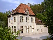
- avenue Dolhez (at n ° 586 is the house and workshop of the internationally renowned sculptor Olivier Strebelle)
- Percke Street
- 3 Verrewinkel wood Rue de Percke, 1180 Uccle permanently open. free. – 15 hectares. This wood, like its little neighbor of Buysdelle, was once part of the Sonian forest before being separated from it by a district of villas. The interest of entering it lies especially during the spring when the ficaria, anemones and hyacinths bloom. Be careful, however, that only pedestrians are allowed on the two paths in the woods.
- Picturesque drève
- avenue des Sorbiers
- avenue d'Hougoumont
- Bergmans road
- 4 Sonian Forest permanently open. free. –
 4,383 hectares. Although it is one of the largest peri-urban forests in Europe, it is only the vestige of the vast forest that once covered much of Brabant and northern France. One of the main characteristics of the Forêt de Soignes is that nearly 80% of it is made up of beeches from plantations or natural regeneration, the high forests of which are nicknamed nearly 70% of the surface of the massif "cathedral beech" . This is a vast area of a single species which makes the forest vulnerable because, despite the completely unique aspect of this typical landscape of the Sonian forest, it is not conducive to the development of the forest. 'a large number of animal and plant species. This first of the two sections which take the forest of Soignes is done by the Chemin des Deux Montagnes, on a ridge overlooking the valleys of Vuylbeek and Karregatbeek. We pass through landscapes alternating "cathedral beech", copses under woodland, clearings or even young plantations where, with a little luck, you can see a deer or wild boars. The route also runs along a Neolithic site .
 - avenue des Deux Montagnes
- 2 End flint road
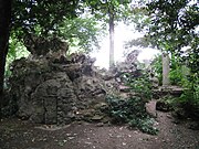
False rocks in the Kinsendael reserve.
.JPG/180px-20120815_Zonienwoud_(32).JPG)
Pond in the Sonian forest.

The forest of Soignes.

.JPG/180px-20120815_Zonienwoud_(32).JPG)

The Woluwe valley
- Course highlighted in medium sea green on the map.
The stage takes the walker along the Brussels part of the Woluwe valley from the point of confluence of the three streams which are at its origin.
- Distance: 9 km
- 3 Departure flint road
- 5 Tournay-Solvay Park Chemin des Silex, 1170 Watermael-Boitsfort permanently open. free. – 7 hectares. This landscaped park is the result of successive developments carried out by the Tournay-Solvay family between the end of the 19th century.e century and the beginning of the XXe century. In addition to two ponds, the park contains the old stables and concierge, both restored in 1992, of the estate as well as the ruins of the castle and the White Villa formerly intended to receive visitors and now headquarters of the European Foundation for Sculpture. Several sculptures also adorn the park.
- flint road
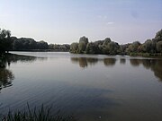
- 6 Watermael-Boitsfort ponds Chemin des Silex, 1170 Watermael-Boitsfort permanently open. free. – 5.7 hectares. A remarkable biological and landscaped ensemble, made up of mowing peerages, recognized as a site Natura 2000. The two ponds that make up this set collect the water from the three streams at the origin of the Woluwe. The lower pond has a terrace for observing the aquatic flora and fauna. More than 130 species of birds coexist here, some of which are very rare in the Region, such as the dwarf Bonglios, the smallest of the European herons, and the Little Grebe, the smallest of the grebes and which has the particularity of laying twice a day. year.
- Chaussée de La Hulpe
- rue du Buis
- 7 Watermael-Boitsfort cemetery Rue du Buis 57, 1170 Watermael-Boitsfort free. – In this small cemetery, on the edge of the Sonian forest, are, among others, buried Doctor Antoine Depage, crossing paths nbone 105 and 112, surgeon and chief physician of the Belgian army on the front of the Yser during the First World War and Constantin Héger, in the middle of the alley no 104, French teacher secretly and passively loved by Charlotte Brontë.
- Drève de Bonne-Odeur (opposite rue du Grand Veneur)
- 8 Sonian Forest permanently open. free. – 4,383 hectares. After a section covered during the first stage, the walk again borrows, for a shorter section, the forest of Soignes.
- Tenreuken
- 9 Ten Reuken Park (Ten reuken means "cleared wood" in the Brabant dialect) Boulevard du Souverain, 1170 Watermael-Boitsfort permanently open. free. – 6.68 hectares. Created at the beginning of XIXe century in the context of the construction of the Boulevard du Souverain, it consists, for the most part, of a pond surrounded by a meadow flowered with daisies, yellow and white bedstraw and granulated saxifrage. Many trees in the park are also among the remarkable trees of the Brussels Region and many water birds frequent the pond such as Gallinules moorhens, Egyptian Goose, mallards, coots, herons, Great Crested Grebes or Tufted Ducks.
- 10 Seny Park Boulevard du Souverain, 1170 Watermael-Boitsfort permanently open. free. – 3.12 hectares. Landscaped park, it was only created at the end of the 1950s and inaugurated in 1963. It provides rest, food, reproduction and hibernation to 14 species of bats and in particular to the barbastelle, the Vespertilion of the marshes, the Vespertilion with scalloped ears and the Great Murine.
- path along the Woluwe
- Jacques Bassem street
- 11 Bergoje Park (Berg means "hill" and oje "house" in the Brabant dialect.) Rue Jacques Bassem, 1160 Auderghem permanently open. free. – 1.68 hectares. Relic of the Forêt de Soignes from which it was separated in 1729 during the construction of the Chaussée de Wavre, it has become an enclosed green space serving as a passage-walk between the various buildings that surround it. Pedunculate oaks, beeches and chestnut trees form the majority of the flora of the park.
The European Foundation for Sculpture in the Tournay-Solvay park.

“Cathedral beech wood” in the Sonian forest.

Ten Reuken Park.

Entrance to Bergoje Park.


- Jacques Bassem street
- Chaussée de Wavre
- rue Émile Idiers
- avenue de la Sablière
- avenue Tedesco
- place Félix Govaert
- Railway promenade
- 12 Woluwe Park Boulevard du Souverain and avenue de Tervuren, 1150 Woluwe-Saint-Pierre permanently open. free. –
 62 hectares. This landscaped park created between 1901 and 1910 at the instigation of King Leopold II contains three ponds, a romantic bridge, rock gardens, waterfalls. Among the trees of the 180 species present, about twenty, including a giant sequoia of 7 meters in circumference, are classified as “remarkable tree” by the Monuments and Sites Commission.
 - 13 Mellaerts Ponds Park Boulevard du Souverain and avenue de Tervuren, 1150 Woluwe-Saint-Pierre permanently open. free. – 8.95 hectares. The park, which has two ponds, and a leisure area is much more open than the three other neighboring parks with which it forms a whole. On the larger of the two ponds, there is a rental business for pedal boats and small boats allowing, during the summer, navigation among swans, geese and other ducks. In its waters hides theAnodonta a species of freshwater mussel that can reach 30 cm length. On the edge of this pond, a chalet where we sell refreshments and an 18-hole mini-golf course open from Monday to Friday from 11 h - 18 h 30 (20 h 30 Thursday) and Saturdays and Sundays from 11 h - 19 h. In the waters of the smallest of the ponds, fishing for carp and small white fish is permitted.
- 14 Brussels urban transport museum Avenue de Tervuren 364B, 1150 Woluwe-Saint-Pierre,
 32 2 5153110 (during opening hours), 32 2 5153108 (outside opening hours) from Easter to the first weekend of October every Saturday, Sunday and public holiday from 13 h - 19 h. child <6 years old: free, child 6 to 11 years old: 3 €, adolescent and adult 12 to 64 years old: 6 €, senior> 65 years old: 4 €, supplement for a journey by historic tram: 3 €. – Installed in a former depot of the STIB, the museum exhibits on 1 500 m2 a large collection of trams, buses, trolleybuses and taxis that have crisscrossed Brussels between 1869 and today. In addition to visiting the museum, it is possible, on certain dates, to take an old tram or an old bus.
 - Railway promenade
- 15 Sources Park Boulevard de la Woluwe, 1150 Woluwe-Saint-Pierre and 1200 Woluwe-Saint-Lambert permanently open. free. – 4.5 hectares. Created at the beginning of the XXe century, it owes its name to the many sources which feed its lower pond dug between 1914 and 1918. It is populated by yellow water lilies and other submerged hydrophyts while its banks are partially colonized by semi-aquatic vegetation of yellow Iris, the symbol of the Brussels-Capital Region, and of Cirse maraîcher. Four jetties allow you to advance above the water and, to the east, you can discover ecological gardens rented by the municipality of Woluwe-Saint-Lambert for the benefit of its inhabitants.
- Railway promenade
- Chaussée de Stockel
- 16 Murals Chaussée de Stockel 80, 1200 Woluwe-Saint-Lambert – These are two giant wall frescoes produced by a graphics workshop in 2000 on a former workshop on the Brussels-Tervueren line of the Belgian State Railways. One represents a train passing in front of the verbrande molen and the other on Lindekemale mill.
- Struykbeken path
- stadium alley
- 17 Malou Park Chaussée de Stockel, 1200 Woluwe-Saint-Lambert permanently open. free. – 8 hectares. Mostly wooded and initially created in the 17th centurye century, it will be remodeled several times until the end of the 19th century.e century. The Louis XVI-style residence, with a view of the large pond, dates from 1776 and, which has become the property of the municipality of Woluwe-Saint-Lambert, now hosts exhibitions, conferences and serves as a reception venue. In the park, allée Pierre Levie, there is also a large playground equipped with a refreshment bar where we serve grilled meats cooked on the barbecue on weekends.
- 18 Lindekemale Mill Avenue Jean-François Debecker 6, 1200 Woluwe-Saint-Lambert – Old water mill, the oldest parts of which date from the 12the century and whose functional paddle wheel, renewed in 1994, 2,3 m in diameter and weighing 2 800 kg runs night and day. Throughout the first half of the XXe century, the miller opened a tavern on the ground floor and rented rooms upstairs. Currently, the buildings house a gourmet restaurant.
.JPG/180px-2286-00020_Parc_de_Woluwe_(11).JPG)
Woluwe park.
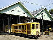
The Brussels urban transport museum.

The park and the Malou castle.
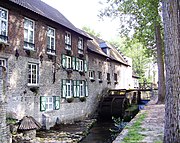
Lindekemale mill.
.JPG/180px-2286-00020_Parc_de_Woluwe_(11).JPG)


- This section of the green promenade is divided either from the west, along the Woluwe stream or from the east and the slope of this stream. Both routes are accessible to both pedestrians and cyclists.
- straight on from the west:
- Vellemolen path
- 19 Slot Park (Slot means "lock" in the Brabant dialect and in Dutch) Boulevard de la Woluwe, 1200 Woluwe-Saint-Lambert permanently open. free. – 0.9 hectare. Small semi-natural park largely wooded with a pond called "The Hinnisdael fountain" although it is only a water retention pond built in 1982 during the extension works of the Brussels metro.
- 20 The Slot Boulevard de la Woluwe 71, 1200 Woluwe-Saint-Lambert – Remains of an old castle, home of the lords of Woluwe. Although the current building dates from the XVIe century, the oldest parts date from the 14the century. Restored in 1986, it is currently used as a restaurant.
- 21 Hof ter Musschen Park (Hof ter musschen means "farm of sparrows" in the Brabant dialect) Boulevard de la Woluwe, 1200 Woluwe-Saint-Lambert permanently open. free. – 10 hectares. The park, which overlooks the Woluwe stream, is made up of a poplar grove, a wood and peerages. It owes its name to the eponymous farm which is there and whose oldest parts, in rubble, date from the 15th century.e century. This western section follows the Woluwe stream partly in the undergrowth and partly along a wet meadow.
- to the right from the east:
- avenue Jean-François Debecker
- avenue de la Chapelle
- 22 Chapel of Marie-la-Miserable Avenue de la Chapelle, 1200 Woluwe-Saint-Lambert every day of 7 h 30 - 18 h (except during the services which take place every day of 8 h - 8 h 30 and Sunday of 8 h - 10 h). free. – Ensemble made up of a chapel and a small hermitage in Brabant Gothic style and dating from the 14th centurye century. The most valuable work contained is undoubtedly the triptych dating from 1609 which recounts six episodes in the life of Mary the Miserable and attributed to the Flemish painter David Teniers the Elder. The garden surrounding the buildings was designed by the landscape architect René Pechère in 1975.
- Klakkedelle Street
- Drève Hof ter Musschen
- 23 Hof ter Musschen Park (Hof ter musschen means "farm of sparrows" in the Brabant dialect) Boulevard de la Woluwe, 1200 Woluwe-Saint-Lambert permanently open. free. – 10 hectares. This second section of the walk leads us to the upper part of the park where we can see, in addition to the typical Brabant farm hof ter musschen, the verbrande molen, which means "mill burned" in Dutch. It is about a windmill transferred, in 1960, in this place and coming from the province of Hainaut. It can be visited all year round, every 1er and 3e Saturday of the month of 14 h - 18 h, as well as every 1er Sunday of the month of 10 h - 18 h.
- straight on from the west:
- avenue Hippocrates
- 4 End boulevard de la Woluwe
The castle of Slot.

The Woluwe in the Hof ter Musschen park.

The chapel of Marie-la-Miserable and its hermitage.

the verbrande molen in the Hof ter Musschen park.


Between Senne and Woluwe
- Course highlighted in Brown on the map.
The stage, via the plateau of Loo, former granary and then horticultural of Brussels, takes you from the main tributary of the Senne, the brook of the Woluwe, to this one, to the place where it reappears after its long underground crossing of the city of Brussels.
- Distance: 6,5 km
- 5 Departure boulevard de la Woluwe
- Hof ten Berg
- Kleinenberg
- rue Théodore De Cuyper
- avenue Marcel Thiry
- avenue Jean Monet
- Yorkshire Avenue
- 24 Val d'Or (Gulledelleveld means "generous fields" in the Brabant dialect) Rond point Gulledelle, 1200 Woluwe-Saint-Lambert permanently open. free. – 11.5 hectares. Site half occupied by a wood and half by grassy wasteland and thickets. Until 1963, it was a quarry for extracting sand and clay intended for the manufacture of solid fired bricks.
- path of the Two Houses
- place of the Holy Family
- Bluets Street
- 25 Roodebeek Park Rue de la Charrette, 1200 Woluwe-Saint-Lambert permanently open. free. – 4.5 hectares. Forest area converted into an arboretum.
- rue de la Charrette
- avenue du Capricorne
- trails
- Clos du Dauphin
- avenue des Constellations
- avenue des Pléiades
- avenue Léon Grosjean
- path
- Hugo Verriest Street
- 26 Church of St. Joseph Place Jean De Paduwa, 1140 Evere every day of 9 h - 18 h. free. – Inaugurated in 1906, among the remarkable objects there is a composite tribune organ dating from the 1920s, the work of the maker Théo Boeckx, the stained glass windows of the choir and the baptismal font.
- avenue du Cimetière de Bruxelles


- 27 Brussels cemetery Avenue du Cimetière de Bruxelles, 1140 Evere from Tuesday to Sunday from 8 h 30 - 16 h. free. – 38 hectares. Inaugurated in 1877 on the territory of the municipality of Evere, it is the largest cemetery in the Brussels-Capital Region. It takes the form of a landscaped park with wide avenues, many trees and flowerbeds. It includes various memorial necropolises including that of the fighters of the Belgian Revolution, the Battle of Waterloo, the two world wars and, in another genre, the fire at the Innovation store. Among the personalities buried there, in addition to the mayors of the city of Brussels, we find the French painter Jacques Louis David, the football coach Raymond Goethals, the founder of the SABCA and first director of the Sabena Georges Nélis, the creator of the body mass index Adolphe Quetelet, the composer of the Belgian national anthem François Van Campenhout, the Minister of State Paul Vanden Boeynants, the architect, among others, of the Royal Military School of Brussels Henri Van Dievoet, the founder of the Free University of Brussels Théodore Verhaegen, etc. In addition to the site, 38 burials, including that of the painter Jacques Louis David, are separately classified as the protected heritage of the Brussels-Capital Region.
- Unique Tree Street
- 28 Evere Park Avenue Constant Permeke, 1140 Evere permanently open. free. – 1.7 hectares. Wooded space that forms, with the adjoining sports complex François Guillaume de 9.75 hectares, a set predestined for walks and relaxation. The sports complex has, among other things, a heated swimming pool 30 ° C open every day from 8 h - 19 h and Thursday until 21 h.
- parallel Universe square
- 29 Sculpture Parallel Universes Square des Univers Parallèles, 1140 Evere – Monumental sculpture in polished steel by Fabienne Defrance in honor of the artistic concept of parallel universes invented by sculptor Vincent Strebell.
- alleys of Provence
- square Servaes Hoedemaekers
- rue Jean-Baptiste Bauwens
- Haecht causeway
- avenue Guillaume Van Leeuw
- Plaine d'Aviation Street
- street of Paris
- Marne Street

- 30 Doolegt educational park Rue de la Marne, 1140 Evere permanently open. free. – 2.5 hectares. The town has built an artificial pond there 200 m2. The set allows children of municipal primary education to become aware of the protection of nature and the importance of biodiversity.
- by the two tunnels for gentle circulation under the streets of Picardie and Stroobants
- 31 Saint-Vincent Park (Bon Pasteur park) Rue Stroobants, 1140 Evere permanently open. free. – 9.9 hectares. Area occupied, in part, by sports fields and, in part, by a wooded area. The park overlooks the Moeraske nature reserve and, from this point , panorama over the nature reserve, the Schaerbeek railway station as well as towards Laeken where one can see, emerging from the trees, the Atomium, the royal greenhouses and the Japanese tower. At the east end of the park stands the Saint-Vincent church which is the oldest building in the town; the tower, which is the oldest part, dates back, at the latest, to the beginning of XIIIe century. Visit only during worship hours.
- rue de Carli


- 32 Moeraske (Moeraske means "small marsh" in the Brabant dialect) Rue Carli, 1140 Evere, 32 2 2425043 (to find out about the terms and conditions of the guided tours) permanently open. free guided tour every second Sunday of the month at 10 h. –
 7.7 hectares. Natural area, listed as a listed heritage of the Region, crossed by the Kerkebeek stream which feeds a marshy area, ponds and a wet meadow. The herpetofauna present includes several species of newts and frogs while the site offers shelter to more than sixty species of birds, a third of which are nesting. Also present are the European Rabbit, the European Polecat and the European Weasel, the Red Fox.
- 33 Ecological gardens Rue Carli, 1140 Evere permanently accessible path. – 1.8 hectares. Plots of communal land rented free for organic farming and equipped with apiaries for pollinating the flowers in the gardens and in the neighboring Moeraske reserve. As soon as you enter the path, on the left, is the last of the air raid shelters used by German sentries at Schaerbeek station during the Allied bombings of World War II.
- 34 Walckiers Park Rue Walckiers, 1030 Schaerbeek guided tours on Saturday and Sunday at 10 h and 14 h (duration : 2 h). Meet in front of the Sainte-Famille school, rue Chaumontel. free. – 4.5 hectares. Created in 1860, it was one of the continent’s first “English” gardens. Returned to the wild, it is, unfortunately, only accessible by guided tour. The two artificial caves built in the 2e half of XVIIIe century are home to a bat colony.
- Walckiers Street
- 35 “Risks of war” mural Walckiers Street no 44, 1140 Evere – Advertisement painted on the gable end of a house dating back to shortly before the Wehrmacht invaded Belgium at the start of World War II. The RGT insurance company was the sponsor of this advertisement boasting a policy insuring the signatories against damage due to war. In 1940, it was visible from trains passing below. Unfortunately, given the scale of the destruction and the huge amounts of compensation, the company went bankrupt. The fresco is classified as part of the real estate heritage of the Region.
- rue Chaumontel
- avenue Zénobe Gramme
- avenue Georges Rodenbach
- Princess Elisabeth Square

- 36 Train World Place Princesse Élisabeth, 1030 Schaerbeek, 32 2 3352280 Tue.- Sun. : 10 h - 17 h (open to the public from September 25, 2015). between 26 and 65 years old: 10 €, <26 years old and> 65 years old: 7,5 €, under 6 years old: free, PMR : 7,5 € (free for the accompanying person). – Museum of SNCB which presents rolling stock made up of steam locomotives, whose life-size reproduction of the The Belgian guy from 1835 as well as a type 12 numbered 12.004 with a blue ribbon in 1939 with a passenger convoy speed of 165 km / h., but also diesel and electric tractors as well as cars and freight wagons. Also on display are models, non-rolling stock and documents; all presented by a modern audiovisual staging. One of the attractions is the driving simulator. The premises are made up of two buildings, one modern and built between 2012 and 2015, the other being the old Schaerbeek station, the oldest parts of which, on the left and on the right, date from 1887 while the central part , which contains the style ticket office Art Nouveau, dates from 1913. This building is classified as part of the real estate heritage of the Region. Catering, free parking.
- avenue Monplaisir
- Lambermont Boulevard
- avenue Jules Van Praet (it is here, on the right, that the Senne river reappears after its long underground course under the city of Brussels)
- 6 End Van Praet Bridge
The Heyzel plateau, the royal parks
- Course highlighted in olive on the map.
This stage, which is the shortest of the route, takes the walker around the royal domain of Laeken. At the start of the stage, and over a distance of approximately 1,1 km, the course has a level difference of 38 m that is to say an average rising slope of 3.45% It will also lead us in a number of places due to the will of the one who was nicknamed "the king builder": Leopold II of Belgium.
- Distance: 6,3 km
- 7 Departure Van Praet Bridge
- avenue des Croix du Feu
| WARNING : The Far Eastern museums, that is, the Chinese pavilion and the Japanese tower, are closed due to construction work and the collections are closed until further notice. However, it is still possible to admire the exterior of the buildings. | |
- 37 Japanese Tower Avenue Van Praet, 1020 Laeken, 32 2 2681608 Tuesday to Friday: from 9 h 30 - 17 h, Saturday and Sunday: from 10 h - 17 h. – Built between 1901 and 1904, the tower was inaugurated in May 1905. The building has three parts: the tower itself which, high 40 meters, is a replica of the one that existed during the Universal Exhibition of 1900 in Paris, the entrance pavilion which is really the one that was present during this exhibition and a large staircase connecting the two other parts. If the structural work of the tower was carried out by Belgian companies, but despite everything assembled without nails as is the Japanese tradition, the majority of the interior and exterior decorations were carried out by Japanese craftsmen of Yokohama. However, it should be noted that the tower has six floors whereas Japanese tradition dictates that these are of an odd number. With the neighboring Chinese pavilion, the tower contains part of the collections of the Museum of the Far East and more particularly Japanese porcelain. The upper floors offer a view of the Royal Estate of Laeken.
- 38 Chinese pavilion Avenue Van Praet, 1020 Laeken, 32 2 2681608 Tuesday to Friday: from 9 h 30 - 17 h, Saturday and Sunday: from 10 h - 17 h. – Integrated into an Far Eastern style park of 3.5 hectares, its construction began in 1903 but was not inaugurated until 1910. Originally built to become a luxury restaurant, from its inauguration, it was ceded, like the Japanese tower, to the Belgian State for the purpose of to house collections focused on the Far East. Like the tower, if the shell was executed by Belgian companies, the interior decorations as well as the kiosk were made in the country representing the pavilion, here at Shanghai. Here, the collections are centered on Traditional Japanese Art. The park contains a small playground.
- Madrid avenue
- avenue du Gros Tilleul
- 39 Laeken Park Avenue du Gros Tilleul, 1020 Laeken permanently open. free. – 70 hectares. Créé sous l'instigation du roi Léopold II et inauguré en 1880, ce parc, de style paysager, est le plus anglais des parcs bruxellois. Si c'est ici qu'est érigé, en style gothique, le monumental mémorial au roi Léopold Ier, on y trouve aussi, dans un coin champêtre , la chapelle et la source Sainte-Anne. Au sud-est s'étend le domaine royal de Laeken où est érigé le palais royal de Laeken, résidence du roi Philippe, visible depuis l'avenue du Parc Royal. À l'ouest, s'étend le domaine du Stuyvenberg, résidence du roi Albert II, et, à l'est, le domaine du Belvédère, résidence de la reine Fabiola.
- 40 Parc d'Osseghem Avenue du Gros Tilleul, 1020 Laeken – 17 hectares. Inauguré en 1932 dans le cadre de l'exposition universelle de Bruxelles de 1935, il fut réaménagé pour celle de 1958. Presque exclusivement arboré, il contient un étang en forme de rivière, un théâtre de verdure construit en 1958 et pouvant accueillir 3 000 spectateurs ainsi qu'une piste de santé praticable par les personnes à mobilité réduite et dont le départ est situé avenue de l'Atomium . Sur cette avenue, l'on peut également voir un des derniers bâtiments rescapés de l'exposition universelle de 1958.
- 41 Atomium Square de l'Atomium, 1020 Laeken horaire. enfant < 6 ans et personne handicapée : gratuit, enfant 6 à 11 ans : 6 €, adolescent 12 à 18 ans, étudiant et senior > 65 ans : 8 €, adulte 19 à 64 ans : 11 €. – Érigé à l'occasion de l'exposition universelle de Bruxelles de 1958, ce devait être une construction aussi éphémère que cette dernière ; plus de 50 ans après, et après rénovation complète entre 2004 et 2006, ce monument, devenu un des symboles de Bruxelles, est toujours bien là. Représentant un cristal de fer agrandi 165 milliards de fois, il est haut de 102 mètres et est constitué de neuf sphères de 18 mètres de diamètre pesant, chacune, environ 250 tonnes et reliées entre elles par des tubes. L'accès à la sphère supérieure, d'où le panorama sur Bruxelles et sa région est époustouflant, s'effectue par un ascenseur circulant à 5 m/s dont le toit est vitré afin de mieux apprécier cette vitesse. La descente se réalise, via les tubes reliant les sphères, au choix soit par des escalators soit par des escaliers tandis que les personnes à mobilité réduite peuvent emprunter l’ascenseur. Hormis son point de vue, la sphère supérieure intègre un restaurant, la sphère centrale un bar, une autre un espace pour les enfants, une autre contient un espace pour l'organisation d'animations ou de conférence, une autre encore accueille des expositions temporaire tandis que la sphère de base est réservée à l’exposition permanente consacrée aux années 1950.
- 42 Mini-Europe Boulevard du Centenaire, 1020 Laeken, 32 2 4780550, e-mail : [email protected] horaire. prices. – 2,4 hectares. Ce parc présente des reproductions des plus célèbres monuments de l’European Union à l’échelle 1/25. Environ 80 villes et 350 maisons sont exposées. Il contient également de nombreuses animations comme un TGV, des moulins, le Vésuve en éruption, un Airbus, des camions filoguidés. En fin de parcours, le bâtiment « Spirit of Europe » où sont présentés l'histoire, les différentes cultures et le fonctionnement des institutions de l'Union européenne.
- boulevard du Centenaire
- 8 End place Saint-Lambert

La tour japonaise et le kiosque chinois.

Le pavillon chinois et son kiosque.

Le monument à Léopold Ier dans le parc de Laeken.

La fontaine Sainte-Anne dans le parc de Laeken.

Le théâtre de verdure dans le parc d'Osseghem.

Mini-Europe vue depuis l'Atomium.


Vallée du Molenbeek
- Parcours souligné en vert mer clair sur la carte.
L'étape remonte la vallée du Molenbeek, « ruisseau du moulin » en dialecte brabançon et en Dutch, jusqu'à sa source. Comme lors de l'étape précédente, nombres de lieux visités sont dû à la volonté du roi Léopold II.
- Distance: 6,7 km
- 9 Departure place Saint-Lambert
- avenue Jean Sobieski
- 43 Jardin colonial Avenue Jean Sobieski, 1020 Laeken permanently open. free. – 2,5 hectares. Créé au tout début du XXe siècle à l'initiative du roi Léopold II, c'était, à l'origine, un jardin d'acclimatation pour les plantes récoltées dans l'État indépendant du Congo. Les collections de plantes tropicales sont déménagées, en 1951, vers le tout nouveau jardin botanique national de Belgique et les serres démontées en 1954 pour être remplacées par une pelouse.
- 44 Parc Sobieski et jardins du Fleuriste Avenue Jean Sobieski, 1020 Laeken tous les jours de 8 h 15 - 18 h (20 h from 1er mai au 31 août). free. – 4,5 hectares pour le parc Sobieski et 4,44 hectares pour les jardins du Fleuriste. Ces deux espaces naturels indissociables l'un de l'autre, mais également du jardin colonial, sont uniquement séparés par un petit massif boisé constitué d’arbres de grande taille. À l'origine, le parc Sobieski était le verger du domaine royal de Laeken, où l'on cultivait également, sous serre, la vigne, l'oranger, le pêcher et l'abricotier tandis que les jardins du Fleuriste servait de jardin floricole et séricole où l'on cultivait les fleurs d’ornement destinées aux différentes demeures royales. Actuellement, le parc Sobieski, malgré l'intérêt esthétique de la scénographie mise en scène en 1975 avec, entre autres, des haies de charmes taillés en fenêtre, ne conserve plus que quelques pommiers et poiriers hautes tiges d'origine en son centre ; un étang et une plaine de jeux complètent cette première partie. Les jardins du Fleuriste, quand à eux, ont gardés, avec ses deux belvédères offrant chacun une vue sur une pièce d'eau et un panorama vers l'église royale de Laeken et le palais de justice de Bruxelles, leur cachet original et restent voués à l'horticulture et à la floriculture mais, actuellement, dans un but didactique.
- square Clémentine
- rue Alphonse Wauters
- 45 Square du Prince Léopold Square du Prince Léopold, 1020 Laeken permanently open. free. – 2,3 hectares. Ce petit jardin public de forme ovale est le centre d'une étoile à huit branches formée chacune par une rue. Outre une plaine de jeux et un terrain pour la pratique du mini-foot et du basket-ball, le square possède un Peuplier de Simon de 236 cm de circonférence, en 2006, qui en fait le plus gros de son espèce dans la Région de Bruxelles-Capitale.
- rue Duysburg
- avenue du Comté de Jette
- 46 Parc de la Jeunesse Avenue du Comté de Jette, 1090 Jette permanently open. free. – 4 hectares. Espace vert voué aux pratiques sportives de la planche à roulettes, du football, du basketball et du tennis mais aussi du mini-golf. Une buvette et une plaine de jeux où certains modules de jeux sont adaptés aux enfants en chaise roulante complètent l'équipement du parc.
- 47 Parc Roi Baudouin Avenue du Sacré-Coeur, 1090 Jette permanently open. free. – 47,25 hectares. Cette première partie de 17,65 hectares du parc correspond à un parc classique avec alternance de pelouses, d'étangs, de massifs fleuris, d'espaces boisés et d'aménagement pour les enfants. Un parcours d’orientation y a spécialement été aménagé pour les personnes en chaise roulante.
- rue Antoine Baeck
- passerelle surplombant l'avenue de l'Exposition


- 48 Parc Roi Baudouin Avenue de l'Exposition, 1090 Jette permanently open. free. – La deuxième partie, vaste de 19,6 hectares du parc et formant un ensemble de 62,3 hectares avec le Poelbosch et le bois du Laerbeek voisins, est d'aspect plus rural et naturel avec des prairies, des vergers et des zones boisées. Elle est à parcourir par la Petite rue Saint-Anne, qui longe la roselière, et la rue du Bois, le long de laquelle ce trouvent les vestiges d'une villa gallo-romaine datant du IIe century.
- rue du Bois

- 49 Marais de Ganshoren Rue du Bois, 1083 Ganshoren permanently open. free. – 11,9 hectares. Coincé entre deux lignes de chemin de fer, le marais est un des derniers vestiges des zones humides de la vallée du Molenbeek. Il connu comme aire de nourrissage et d’habitat pour 12 espèces de chauves-souris parmi lesquelles le Grand murin, la Barbastelle d'Europe et le Vespertilion des marais. Plus de 65 espèces d'oiseaux fréquentent le site ou y nichent tandis que de nombreux amphibiens y vivent de même que la Couleuvre à collier.
- sentier Guy Demanet
- rue Nestor Martin
- avenue Marie de Hongrie
- place Marguerite d'Autriche
- 50 Zavelenberg (Zavelenberg signifie « montagne de sable » en dialecte brabançon) Boulevard Charles Quint, 1082 Berchem-Sainte-Agathe permanently open. free. – 16 hectares. La typologie de cette surface publique est assez particulière. C'est celle d'un espace rural structuré, comme par le passé, par des haies, des clôtures et des petits groupes d'arbres. Elle constitue aussi le seul endroit de la Région de Bruxelles-Capitale où pousse l'Hellébore vert. Dans les prairies paissent les bovins du dernier exploitant agricole de la Région.
- clos du Zavelenberg
- avenue des Bardanes
- chaussée de Zellik
- rue des Châlets
- avenue du Hunderenveld
- rue des Chats
- 51 Kattebroek Rue des Chats, 1082 Berchem-Sainte-Agathe permanently open. free. – 4,4 hectares. Zone de prairie bordée par un petit bois.
- rue de Dilbeek
- rue Potaarde
- Kweeperenboomlaan
- avenue du Cognassier
- drève des Maricolles

- 52 Bois du Wilder Drève des Maricolles, 1082 Berchem-Sainte-Agathe permanently open. free. – 8,2 hectares. Espace boisé semi-naturel doucement vallonné avec des mares et, en son centre, un étang. Parmi la flore des sous-bois, on y trouve la Violette odorante, plusieurs espèces de myosotis, le Géraniums des prés et même, le long du cimetière communal, quelques espèces d'orchidées des régions tempérées ; au printemps y fleuri la Jacinthe des bois, l'Ail des ours, l'Anémone sylvie et la vraie jonquille. Du côté de l' avifaune, l'Accenteur mouchet, le Rouge-gorge, la Mésange bleue et la Mésange noire y sont nicheurs. La Grenouille rousse et diverses espèces de tritons peuplent l'étang et les mares.
- 10 End rue Kasterlinden
Pajottenland
- Parcours souligné en bleu denim sur la carte.
Aussi appelé la Toscane du Nord, bien que le houblon destiné à la fabrication de la bière lambic y remplace la vigne, le Pajottenland est le berceau du cheval de trait brabançon.
- Distance: 6,8 km
- 11 Departure rue Kasterlinden
- rue Émile Heylens
- rue Ferdinand Elbers
- rue de la Vieillesse heureuse
- 53 Parc régional du Scheutbos Rue de la Vieillesse heureuse, 1080 Molenbeek-Saint-Jean permanently open. free. – 6,22 hectares. Espace à vocation écologique et récréative qui, malgré son nom, n'est plus un bois (bos signifie « bois » en néerlandais) mais, à raison de 70 % de son espace, une série des prairies et, pour le reste, de friches arbustives. C'est ce mélange qui donne, non seulement, au parc des qualités paysagères intéressantes de bocage mais aussi sa grande biodiversité. Ainsi, s'y côtoient plus de 300 espèces de plantes à fleurs, 87 variétés de champignons, 66 essences d’arbres et d’arbustes ainsi que 120 types d’insectes différents dont 30 espèces de papillons, de multiples espèces d'oiseaux nicheurs, dont le Faucon crécerelle, et de nombreux petits rongeurs comme le plus petit, avec ses six grammes environ, de la faune européenne : le rat des moissons.
- rue de la Tarentelle
- avenue de la Poésie
- parc du Peterbos
- avenue Shakespeare
- boulevard Joseph Bracops
- boulevard Sylvain Dupuis (passer sous le pont du boulevard périphérique R0)
- Kaudenaardestraat
- 82 m après le pont
- avenue de la Fécondité
- rue de l’Enthousiasme
- rue Pierre Van Reymenant
- rue des Papillons
- rue de Scherdemael
- 54 Parc de la Pede Rue de Neerpede, 1070 Anderlecht permanently open. free. – 24 hectares. Ce parc doit son nom au ruisseau de la Pede qui le traverse et qui est un affluent de la Senne. Partie intégrante d'un ensemble récréatif beaucoup plus vaste qui comporte un centre sportif, avec une piste de ski synthétique, et un terrain de golf de 18 trous, il est principalement constitué d'un étang et d'un bassin d'orage dont le chemin qui parcourt le pourtour de chacun offre de belles vues.
- rue du Chaudron
- route de Lennik
- 12 End rond point Henri Simonet

Dans le parc régional du Scheutbos.

L'étang du parc de la Pede.
Le bassin d'orage du parc de la Pede.


Entre Vogelzangbeek et Geleytsbeek
- Parcours souligné en vert printemps sur la carte.
Cette étape, qui est la plus longue et, la seule, sans lieu de restauration directement le long de son parcours, fait descendre, au promeneur, le vallon du ruisseau du Vogelenzankbeek avant de traverser la vallée de la Senne.
- Distance: 10,3 km
- 13 Departure rond point Henri Simonet
- avenue Joseph Wybran
- rue Meylemeersch
- rue Chant d'Oiseaux
- 55 Vogelenzang (Vogelenzang signifie « chant d'oiseaux » en néerlandais) Rue du Chant d'Oiseaux, 1070 Anderlecht permanently open. free. – 15 hectares. Cet espace semi-naturel doit son nom au ruisseau du Vogelenzangbeek qui marque, à la fois, la limite sud de l'espace semi-naturel et celle entre la Région de Bruxelles-Capitale and the Flemish region. Ce tronçon de la promenade verte est dédoublé soit au nord soit au sud du Vogelenzang. Les deux parcours sont accessibles aussi bien aux piétons qu'aux cyclistes.
- au nord, en grande partie, sur un chemin qui traverse prairies et friches :
- rue Chant d'Oiseaux
- (après le petit bosquet agrémenté de jardins)
- allée Hof ter Vleest
- chaussée de Mons
- rue de Zuen
- au sud, le long du ruisseau du Vogelenzangbeek sur un chemin bordé d'arbres :
- Vogelenzangstraat
- après le groupe des deux premières maisons
- traverser la chaussée de Mons
- rue de Zuen
- au nord, en grande partie, sur un chemin qui traverse prairies et friches :

- quai de Veeweyde (le parcours longe les quais du canal à grand gabarit Charleroi-Bruxelles sur 1,14 km)
- pont Arthur Dehem
- quai de Aa
- 1er sentier à gauche le long de l'ancien canal puis de la Senne
- boulevard International
- boulevard Industriel
- boulevard de l'Humanité
- rue de la Soierie
- rue de Hal
- 56 Parc du Bempt (Bempt signifie « pré, prairie » en dialecte brabançon) Chaussée de Neerstalle, 1190 Forest permanently open. free. – 6 hectares. Espace ouvert agrémenté de quelques arbres et d'une pièce d'eau. On y trouve aussi une petite plaine de jeux et une ancienne fermette restaurée servant aujourd'hui de maison de quartier. Mais, l'attraction principale du parc est un réseau de chemin de fer miniature à passager.

- 1 Petit train à vapeur de Forest Chaussée de Neerstalle 323b, 1190 Forest (in the parc du Bempt), 32 2 3766996, 32 479 387890 (téléphone portable), e-mail : [email protected] (horaire 2014) d'avril à juin les samedis et dimanches de 14 h - 18 h et de juillet à septembre aux mêmes heures mais uniquement le dimanche. – Réseau de chemin de fer miniature à passager créé par un club d'amateurs en 1985 et long de 2,2 km. Il est à la norme anglaise de 7,25 pouces, pour la circulation de maquettes à l'échelle 1:18, et équipé d'un contre rail permettant un écartement de 5 pouces, pour la circulation à l'échelle 1:12. Le réseau comporte trois circuits différents où circulent des mini wagons à passager pouvant être tirés par une des 34 locomotives à vapeur ou électriques que possèdent le club. Aire de stationnement pour les vélos.
- rue de Lusambo
- rue des Lutins
- chaussée de Ruisbroek
- (avant le n° 76)
- Vrijheidsstraat
- sentier des Peupliers
- parking de délestage de Uccle-Stalle
- rue du Melkriek
- (1er sentier)
- rue Keyenbempt
- 57 Keyenbempt Rue Keyenbempt, 1180 Uccle permanently open. free. – 10 hectares. Vestige des zones marécageuses formées par le ruisseau qui le traverse, cet espace est un environnement champêtre, constitué de marais, de potagers et d'une colline boisée. Dès l'entrée du site, on peut voir, à gauche, l'imposant ancien moulin à eau du Neckersgat dont les parties les plus anciennes dateraient du XIIe siècle et qui fut entièrement rénové en 2011. Vient ensuite une vaste parcelle occupée par des jardins écologiques à côté de laquelle se situe la dernière zone marécageuse qui peut être parcourue grâce à une jetée en bois . La colline boisée qui suit contient, entre autres, un abri, tapissé de verdure, pour l’hibernation des chauves-souris, une zone de ruchers et les vestiges d'un rempart datant du Néolitique .
- chaussée Saint-Job
- 14 End chaussée Saint-Job (sous le viaduc du chemin de fer)
To go

Tout le parcours étant en périphérie de la Région de Bruxelles-Capitale, rejoindre un point quelconque de celui-ci en voiture n'offre, en général, aucun problème de stationnement que ce dernier soit gratuit ou payant. Hormis le dimanche et les jours fériés, il faut cependant éviter les zones à disque de stationnement car celles-ci autorisant, entre 9 et 18 h, une durée maximale de stationnement de deux heures, il sera difficile de monitorer son emploi du temps.
Tous les trains possèdent, au moins, un compartiment pouvant accueillir les bicyclettes et les personnes à mobilité réduite.
Le réseau de transport en commun de la Région étant fort dense, il n'y aura aucune difficulté pour rejoindre un endroit situé, ou vraiment très proche, d'un point quelconque d'une étape. Les rames du métro possèdent tous un endroit réservé au transport des vélos et beaucoup de stations possèdent, au moins, un ascenseur (plan des stations avec un ascenseur). Les trams des séries 3000 et 4000 (numéro de véhicule débutant par 3 ou 4) sont adaptés au transport des personnes en fauteuil roulant mais hormis dans les stations de métro léger, l'accès ou la descente de la plateforme du tram ne pourra se faire sans une aide extérieure. Les autobus possèdent tous un endroit où arrimer une chaise roulante mais, ici aussi, l'accès ou la descente de la plateforme de l'autobus est impossible sans une aide extérieure. En complément du réseau régulier, la STIB organise un service de transport de personnes handicapées, appelé « Taxibus », qui fonctionne sur réservation téléphonique et propose une desserte en « porte-à-porte ». Le service est assuré du lundi au samedi de 5 h - 1 h.
- Taxibus – Informations sur les « Taxibus » de la STIB.

La société Villo! offre des vélos en libre-service et possède des points d'attache couvrant presque toute la Région. Les vélos sont munis de sept vitesses, d'un panier avant, d'un protège carter arrière, d'un éclairage automatique et d'un antivol intégré. Cependant, ils ne peuvent transporter qu'une seule personne et leur masse est assez élevée. Il arrive aussi, peu souvent, qu'une station soit vide de bicyclette ou, plus rarement, saturée donc dans l'impossibilité de recevoir un vélo.
- Villo! – Le site web de la société Villo!
Ci-après, uniquement, les possibilités d'accéder à un point de départ d'une étape, et à fortiori au point d'arrivée de la suivante, en transport en commun ainsi que les stations de vélos en libre-service côtoyant ces mêmes points.
La forêt de Soignes et le Sud d’Uccle
- By train : ligne 161 Bruxelles-Midi ↔ Charleroi-Sud,
station « 1 Uccle-Calvoet »
- By tram : 51 Stade ↔ Van Haelen,
arrêt « 2 Engeland »
- By bus :
- STIB, 43 Observatoire ↔ Kauwberg, arrêt « Engeland »
- STIB, 60 Ambiorix ↔ Uccle-Calvoet, arrêt « Engeland »
- TEC, ligne 40 Uccle ↔ Braine-l'Alleud, arrêt « Engeland ».
- By bike : station Villo! n° 290, chaussée d'Alsenberg ( à la station SNCB d'Uccle-Calvoet).
La vallée de la Woluwe
- By train : ligne 161 zone de Bruxelles ↔ Namur,
station « 3 Boitsfort ».
- By tram : 94 station de métro Louise ↔ Musée du tram,
arrêt « 4 Gare de Boitsfort ».
- By bus : TEC, ligne 366 place Flagey ↔ Court-Saint Étienne, arrêt « Gare de Boitsfort ».
- By bike : station Villo! n° 296, face au n° 187 de la chaussée de La Hulpe.
Entre Senne et Woluwe
- By bus :
- STIB, 42 Viaduc E40 ↔ Musée du tram,
arrêt « 5 Thiry-Woluwe " Where "6 Hof ter Musschen »
- STIB, 79 Kraainem ↔ Schuman,
arrêt « Thiry-Woluwe " Where "Hof ter Musschen »
- De Lijn, ligne 359 Zaventem-Luchthaven ↔ Rodebeek-Metro,
arrêt « 7 Sasstraat " Where "Thiry-Woluwe »
- De Lijn, ligne 659 Zaventem-Luchthaven ↔ Rodebeek-Metro,
arrêt « Hof ter Musschen " Where "Thiry-Woluwe »
- By bike : station Villo! n° 335, face au n° 100 du boulevard de la Woluwe.
Le plateau du Heyzel, les parcs royaux
- By train : gare de Schaerbeek
- lignes 25 zone de Bruxelles ↔ Anvers-Central ;
- ligne 26 Hal ↔ Schaerbeek ;
- ligne 27 Bruxelles-Nord ↔ Anvers-Central ;
- ligne 28 zone de Bruxelles ↔ Schaerbeek ;
- ligne 36 Bruxelles-Nord ↔ Liège-Guillemins.
- By tram :
- 3 Esplanade ↔ Churchill,
arrêt « 8 Van Praet » ;
- 7 Vanderkindere ↔ Heysel,
arrêt « Van Praet » ;
- 92 Fort Jaco ↔ Schaerbeek Gare,
terminus "9 Schaerbeek Gare ».
- By bus : STIB57 Gare du Nord ↔ Hôpital Militaire, arrêt « Van Praet ».
- By bike : stations Villo!
- n° 277, avenue Van Praet (face à l’arrêt des trams) ;
- n° 160, place Princesse Élisabeth (face à la gare de Schaerbeek).
Vallée du Molenbeek
- By tram :
- 7 Vanderkindere ↔ Heysel,
arrêt « 10 Centenaire » ;
- 19 Groot-Bijgaarden ↔ De Wand,
arrêt « Centenaire » ;
- 51 Van Haelen ↔ Heysel,
arrêt « Centenaire ».
- By bike : station Villo! n° 282, face au n° 90 du boulevard du Centenaire (carrefour avec l'avenue des Ébéniers).
Pajottenland
- By bus : STIB, 84 Beekant ↔ Heysel, arrêt « 11 Cimetières ».
Entre Vogelzangbeek et Geleytsbeek
- En métro : 5 Herrmann-Debroux ↔ Erasme,
terminus "12 Erasme » ![]()
- By bus :
- De Lijn, ligne 141 Brussel-Zuidstation ↔ Leerbeek,
arrêt « 13 Multipharma » ;
- De Lijn, ligne 142 Brussel-Zuidstation ↔ Leerbeek,
arrêt « 14 Yserkruis ».
- By bike : station Villo! n° 347, n° 808 route de Lennik (crèches de l’hôpital Érasme).
Eat
Tous les lieux de restauration cités sont sur le parcours ou à moins de 50 meters de celui-ci. Ils apparaissent dans l'ordre de leur situation géographique par rapport à l'avancée dans l'étape.
La forêt de Soignes et le Sud d’Uccle
- 1 La Branche d'Olivier Rue Engeland 172, 1180 Uccle (au carrefour des rues Engeland et Verrewinkel), 32 2 3757690, fax : 32 2 6742676, e-mail : [email protected] fermé samedi midi et dimanche. carte, menu « panachable » à 30 €. – Cuisine de brasserie, menus pour enfants, chiens acceptés. Terrace. Possibilité de garer son vélo en bordure de la terrasse.
La vallée de la Woluwe
- 2 Au Repos des Chasseurs Avenue Charle-Albert 11-13, 1170 Watermael-Boitsfort (directement à gauche en sortant de la forêt de Soignes), 32 2 6604672, fax : 32 2 6742676, e-mail : [email protected] tous les jours de 11 h - 23 h. carte, menus at 24,5 € and 41,5 €. – Cuisine française et italienne, spécialité de gibier en saison. Hotel. Possibilité de garer son vélo sur l'aire de stationnement privative de l'établissement.
- 3 Le Schievelavabo (Schieve lavabo est une expression bruxelloise signifiant littéralement « lavabo fou » pour un « lavabo de guingois » et désignant de façon imagée un « râleur ») Rue Jacques Bassem 111, 1160 Auderghem, 32 2 6752020 du lundi au jeudi : de 12 h - 14 h 30 and18 h 30 - 22 h 30 (vendredi jusque 13 h), samedi : de 18 h 30 - 23 h, dimanche : de 18 h 30 - 22 h. carte, menus à 22, 25 et 29 € menus enfant entre 7 et 8,5 €. – Brasserie cuisine.
- 4 L'Eat O Clock Chausée de Wavre 1680bis, 1160 Auderghem, 32 2 2222222 carte. – Petite restauration. Take away food. Possibilité de garer son vélo devant l'établissement.
- 5 Bosphorus Chausée de Wavre 1668, 1160 Auderghem, 32 2 6737305 from Tue.- Sun. : 11 h 30 - 23 h 30. – Restauration rapide, spécialité de pittas et de dürüms. Take away food. Réservation plus que nécessaire pour manger sur place.
- 6 Brasserie des Étangs Mellaerts Boulevard du Souverain 275, 1150 Woluwe-Saint-Pierre (in the parc des Étangs Mellaerts), 32 2 7793619 tous les jours de 12 h - 22 h (jeudi, vendredi et samedi jusque 23 h). carte. – Brasserie cuisine. Véranda et terrasse chauffée, pleine de jeux. Possibilité de garer son vélo sur l'aire de stationnement privative de l'établissement.
- 7 Il Due Signori Avenue de Tervueren 368, 1150 Woluwe-Saint-Pierre (entrée directement par le parcours de la promenade verte ou par l'avenue Edmond Parmentier), 32 2 7792323, e-mail : [email protected] from Mon.- Game. : 11 h 30 - 21 h 30, vendredi : de 11 h 30 - 22 h, samedi : de 12 h - 22 h. carte, menus de 35 à 78 €, from Monday to Friday noon two courses at 25 €. – Italian gourmet cuisine. Possibility to park your bike on the establishment's private parking area.
- Lindekemale Mill Avenue Jean-François Debecker 6, 1200 Woluwe-Saint-Lambert (in the Lindekemale mill), 32 2 7709057, fax : 32 2 7629457, e-mail : [email protected] closed Monday, Saturday lunchtime and Sunday evening. menu of the month, from Tuesday to Friday noon two courses at 25 €. – French cuisine. Covered terrace. Within the framework of an old water mill, the oldest parts of which date from the 12the century. Possibility to park your bike on the establishment's private parking area.
- Colmar Woluwe Boulevard de la Woluwe 71, 1200 Woluwe-Saint-Lambert (in the castle Slot), 32 2 7629855 from Sun.- Game. : 11 h 30 - 21 h 30 , Friday and Saturday: from 11 h 30 - 22 h. weekday card, weekend card, children's menus between 6,5 € and 9,45 €. –
 free. French and international cuisine. Terrace. Possibility to park your bike on the establishment's private parking area.
Between Senne and Woluwe
- 8 Val d'Or Avenue Marcel Thiry 59, 1200 Woluwe-Saint-Lambert, 32 2 7725006 Monday to Friday from 12 h - 15 h 30. between 25 and 35 €. – Fusion cuisine.
- 9 Evergreen Avenue du V-Day 1-3, 1140 Evere (corner of avenue Léon Grosjean and avenue du V-Day), 32 2 7267015, e-mail : [email protected] Monday to Friday from 11 h 30 - 14 h and19 h - 23 h, the Saturday of 11 h 30 - 14 h and from 7 to midnight. – Brasserie cuisine. Hotel. Possibility to park your bike in the courtyard of the establishment.
- 10 Dupont Cafe Avenue du Cimetière de Bruxelles 151, 1140 Evere, 32 2 7262901, e-mail : [email protected] Monday to Friday from 12 h - 14 h 30 and18 h - 22 h, the Saturday of 18 h - 22 h 30. map. – Brasserie cuisine.
- 11 Rustic Brasseries Avenue du Cimetière de Bruxelles 155, 1140 Evere, 32 2 7261648, e-mail : [email protected] every day of 12 h - 15 h and18 h 30 - 22 h 30 (Friday and Saturday until 22 h. map, menus at 25 and 35 €. – Brasserie cuisine. Garden terrace at the back. Possibility to park your bike on the esplanade in front of the establishment.

- 12 A taste of home Rue Leekaerts 29, 1140 Evere (behind the town hall), 32 484 109834 (cellphone), e-mail : [email protected] Tuesday to Friday: from 12 h - 14 h and18 h 30 - 22 h, Saturday: from 18 h 30 - 22 h. map, menus at 22 and 28 €. – Restaurant affiliated with the “Slow Food” movement. Specialty of tapas made with fresh local products and focused on Belgian cuisine. Drink menu with aperitifs and beers "made in Belgium". Possibility to park your bike on the property of the establishment.
- 13 The Piazzetta Place de la Paix 20, 1140 Evere, 32 2 2150177 Monday to Friday: from 12 h - 14 h and19 h - 22 h, Saturday of 19 h - 22 h. budget less than 25 €. – Italian cuisine, specialty pizzas. Possibility to park your bike on the Place de la Paix.
The Heyzel plateau, the royal parks
- 14 The Pergola Avenue des Pagodes 445, 1020 Laeken, 32 2 2685849, e-mail : [email protected] brewery: every day from 9 h 30 - 14 h 30 and of 18 h 30 at midnight ; restaurant: Monday to Friday from 12 h - 14 h 30 and18 h - 22 h, Saturday and Sunday from 12 h - 15 h and18 h - 22 h 30. map. – In the restaurant, Franco-Belgian cuisine and in the brasserie, specialty steak tartare prepared in the dining room, simply called “American” in Belgium. Covered terrace. Possibility to park your bike in front of the entrance to the establishment.
- Atomium Restaurant Square de l'Atomium, 1020 Laeken (in the upper sphere of theAtomium), 32 2 4795850, e-mail : [email protected] map, menus 24,5 € To 57,5 €. – Franco-Belgian cuisine. For safety reasons imposed by the fire department of the city of Brussels, frying is prohibited. The restaurant is divided into a panoramic room with a view of the surroundings and a more intimate mezzanine room. Possibility to park your bike on the Square de l'Atomium.
- 15 The Village Boulevard du Centenaire 20, 1020 Laeken for all budgets. – The concept "The Village" is installed on what was "Joyous Belgium", the reconstruction of a town square in 1900, during the 1958 World Fair. The site includes a merry-go-round with wooden horses, two places or just have a drink and nine mouth-watering places ranging from fast food to restaurant-show. Access by bike via the avenue du Centenaire is quite difficult because of a staircase preceding the footbridge giving access to the Bruparck complex (Kinepolis, Mini-Europe, Océade and The Village); it is preferable, from the Atomium to take avenue de Bouchout then, to the right, the avenue du Football and, again to the right, the alley between Mini-Europe and the Océade to the site of The Town. If cycling is not authorized, driving his bike as a pedestrian to the place chosen to eat is allowed.
- 16 The century Avenue Jean Sobieski 84, 1020 Laeken (corner of Place Saint-Lambert and Avenue Jean Sobieski), 32 2 4795600, e-mail : [email protected] from Tuesday to Sunday from 12 h - 15 h and18 h - 23 h. map. – free. French, fusion and halal cuisine. Hotel.
Molenbeek Valley
- 17 Pizzicato 2 Boulevard Émile Bockstael 426, 1020 Laeken (crossroads of rue Alphonse Wauters and boulevard Émile Bockstael), 32 2 4784036 map. – Italian cuisine, pizzeria.

- 18 Chalet du Laerbeek Avenue du Laerbeek, 1020 Laeken, 32 2 4780888 every day of 10 h - 22 h. map. – Brasserie cuisine. Terrace, playground. Possibility to park your bike on the edge of the terrace.
- 19 Basilix Avenue Charles Quint, 1083 Ganshoren Monday to Saturday from 10 h - 21 h 30 (parking closure). – Shopping center with eight places to eat, ranging from brasserie cuisine to sandwich shops. Possibility to park your bike in the parking area of the shopping center.
- 20 Cambrils Avenue Charles Quint 365, 1083 Ganshoren, 32 2 4655070, e-mail : [email protected] from Tuesday to Saturday from 12 h - 13 h 30 and19 h - 21 h, Sunday of 12 h - 13 h 45. 2-course lunch at 25 € and 3 dishes at 28 €, 4-course menu 48 € and 5 dishes 65 €. – Belgian and French cuisine based on seasonal products, fish specialties, catering service. Terrace.
- 21 Auberge du Kasterlinden Rue du Kasterlinden 198, 1082 Berchem-Sainte-Agathe, 32 2 4685899 open every day from 11 h - 22 h 3023 h weekends), closed Saturday lunchtime. map. – Brasserie cuisine. Garden. Possibility to park your bike either in front of the entrance to the Berchem-Sainte-Agathe cemetery or in front of that of Dilbeek.
Pajottenland
- 22 Il Sipario Chaussée de Ninove 675, 1070 Anderlecht, 32 2 4112653 from Wednesday to Monday from 12 h - 14 h 30 and19 h - 22 h 30. menus. – Italian food.
- 23 La Campannina Avenue d'Itterbeek 460, 1070 Anderlecht, 32 2 5246024 Tuesday from 12 h - 15 h, from Wednesday to Sunday from 12 h - 15 h and18 h - 23 h. – Italian food. Possibility to park your bike in front of the entrance of the establishment
- 24 The Chalet de la Pede Rue de Neerpede 575, 1070 Anderlecht, 32 2 5215054 Sunday of 12 h - 18 h, from Tuesday to Saturday from 12 h - 14 h 30 and18 h - 22 h. – Brasserie cuisine. Terrace overlooking the pond in the Parc de la Pede. Possibility to park your bike in the parking area in front of the establishment.
- 25 La Bella Vita Rue de Neerpede 618, 1070 Anderlecht, 32 2 5230660, e-mail : [email protected] every day of 10 h - 15 h and18 h - 23 h 30 (Friday and Saturday until midnight). map, menu at 45 € aperitif and 1/4 liter of wine included. – Italian cuisine, pizzeria.
Between Vogelzangbeek and Geleytsbeek
- 26 La Friterie du Bourdon Chaussée d'Alsemberg 1155, 1180 Uccle (150 m on the left when leaving the Keyenbempt Park), 32 2 3320448 Sunday of 12 h - 22 h, from Tuesday to Saturday from 12 h - 14 h 30 and from 6 to midnight. – Friterie. Small terrace, parking area. According to the sites of French fries lovers Weskonva and Fritkots, the chip shop is ranked in the five best in Brussels with an appreciation score of 5 out of 5. Possibility to park your bike in the large parking area adjacent to the establishment.
Security
 | Emergency telephone number: All emergency services:112 |
Circulation
The entire green promenade is carried out either via soft traffic lanes, that is to say reserved for pedestrians and cyclists, or on cycle paths or sidewalks. If the cycle path crosses a roadway or if, as pedestrians, you have to take a pedestrian crossing, the Belgian driver is, in general, courteous and respects weak users, that is to say according to the code of the Belgian road, cyclists, pedestrians and passengers of a vehicle. However, a moment of distraction from a driver is always possible, it is still necessary to remain vigilant and clearly show your intentions. Please note that if you have to cross the road of a tram, this one always has priority whatever the circumstances.


Concerning more particularly cyclists, they are warned, on a soft traffic lane, of a near danger by a bilingual French-Dutch sign specific to the green promenade and asking them to slow down. They are prohibited from riding their bicycles on a one-way street unless the prohibition sign is accompanied by an additional “bicycles excepted” plate, placed at the exit of a limited one-way street. They are always allowed, or even advised in the absence of a cycle path, to use the sites specific to public transport, and in the same direction of travel as this, unless it is also used by trams. .
Whether you are a pedestrian or a cyclist, know that it is forbidden, in a public place, to let a pet wander. So always keep your dog on a leash; some landscaped parks have fenced areas intended to let it roam in peace.
As a general rule, in a natural or semi-natural area, do not leave the paths and paths, especially if the area where you would like to enter is formally prohibited from access either by the presence of a sign or by that of a fence. . Either it can be done for your safety or it is a fragile area for flora and / or fauna.
Always obey the instructions and injunctions of the agents of theIBGE. Also note that they are empowered to draw up an offense report in the areas of air, water and soil pollution, noise damage and waste abandonment.
Flora and fauna
.JPG/220px-20120815_Zonienwoud_(27).JPG)
The viral disease of rage is not to be feared. This has been eradicated from Belgium since 2001. The only case reported since was that of a young dog illegally imported from Morocco in 2007.
The only potential danger will be the presence of ticks (Ixodida) or, in summer and autumn, chiggers (Trombicula autumnalis) in the tall grass. The only species of snake you might encounter, mostly in swampy areas or along streams, is the grass snake. (Natrix natrix) which is a non-venomous species.

Regarding flora, there is no ban on collecting mushrooms that you are sure to recognize as non-toxic. The same goes for wild fruits or apples and pears in old orchards. The only defense is the use of a blueberry comb. The main risk caused by this flora will come from contact with giant hogweed (Heracleum mantegazzianum), present more particularly along the Molenbeek stream. All this plant contains toxic substances which are activated by sunlight making the skin very sensitive and causing lesions within days. Giant hogweed should not be confused with common hogweed (Heracleum sphondylium) which is an edible plant. The first has more than 50 combs in the umbel while the second has less than 35. If you think you will encounter one, do not tear it out yourself but warn a police officer or, in a forest area, a forest ranger.
- Hogweed (Heracleum mantegazzianum) – What to do in case of contact with the plant.
- Poisonous plants – the National Botanical Garden of Belgium helps you recognize poisonous plants.
Around
The Forêt de Soignes and the south of Uccle
- 1 Dieweg Cemetery (1,160 km from Uccle-Calvoet station) – Cemetery disused since 1958 and where rest, among others, the banker dynasty Lambert as well as Georges Remi, alias Hergé, comic book author and father of the characters of Tintin, Snowy and Captain Haddock.
The Woluwe valley
- 2 Jean Massart experimental botanical garden (630 m from the crossing with the chaussée de Wavre) – Created in 1922 by Jean Massart, professor of botany at theULB, the garden occupies an area of 5 hectares.
- 3 Rouge-Cloître Abbey (in continuation after the experimental botanical garden Jean Massart) – Former Augustinian priory founded around 1367 and surrounded by ponds.
Between Senne and Woluwe
- 4 Enclosure of the executed (740 m from the intersection with rue Colonel Bourg) – Small cemetery with 365 graves of resistance fighters from the two world wars. Located on the former site of the National Tir where, among others, were shot Edith Cavell, Gabrielle Petit and Youra Livchitz.
The Heyzel plateau, the royal parks
- 5 National Botanical Garden of Belgium (4 km from the avenue du Gros Tilleul with the avenue de Madrid. By bus: De Lijn no 250 (direction Puurs) or no 251 (direction Malderen), boarding "Koning Boudewijn" and stop "Plantentium") – One of the largest plant gardens in the world on an expanse of 92 hectares.
Molenbeek Valley
- 6 Church of Our Lady of Laeken (1,42 km after the crossing with boulevard Émile Bockstael) – Neo-gothic church of XIXe century where, under an octagonal chapel behind the apse, is the royal crypt, accessible free of charge according to a well-defined schedule. All the sovereigns of Belgium, and close members of the royal family, deceased since 1850 are buried there.
- 7 Laeken cemetery (80 m after the square of the Notre-Dame de Laeken church) – The oldest of the Brussels cemeteries still in operation, it is known internationally for the rich funeral heritage it contains, including one of the twenty original copies of the Thinker by Auguste Rodin .
- 8 Grand-Bigard Castle (1,48 km from the junction with the Brusselstraat) – Castle built between the XIIe and the XVIIe century surrounded by a wide moat spanned by a five-arched bridge and in a park of 14 hectares.
Pajottenland
- 9 Leuizenmolen (Luizenmolen means "lice mill" in Brabant dialect) (280 m from the intersection with rue du Pommier) – Wooden windmill on a pivot and the last windmill still in operation in the Brussels-Capital Region.
Between Vogelzangbeek and Geleytsbeek
- 10 Chateau Calmeyn (1,17 km from Engeland Square) – Italian-style castle built in 1852 and 1853 on an estate of 14 hectares.