Sonian Forest - Wikivoyage, the free collaborative travel and tourism guide - Forêt de Soignes — Wikivoyage, le guide de voyage et de tourisme collaboratif gratuit
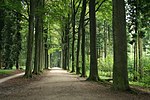
The main characteristic of the Forêt de Soignes is that it is made up of nearly 80% beech trees (Fagus sylvatica) from plantations or natural regeneration, whose high forests have given the nickname part of the forest massif: the "cathedral beech".
In Belgium, the management of the territory being a competence of federated regions, the forest which partly extends over the three regions is managed by them. Each is the mistress of her own home and manages her territory as she sees fit. However, regarding 5,000 hectares made up of the Soignes forest and the green spaces located in and around it, the three regions jointly and in close collaboration administer the whole according to the same master plan.
Brussels Institute for Environmental Management (IBGE) Tour & Taxis, avenue du Port 86C / 3000, 1000 Brussels, 32 2 7757642 – Responsible: Gregory Reinbold. (last update Feb. 2018)
Nature and forest department (DNF) Canton of Nivelles, avenue Jean Monnet 12, 1400 Nivelles, 32 67 884290 – Responsible: Damien Bauwens. (last update Feb. 2018)
Agentschap voor Natuur en Bos (ANB) Beheerregio Groenendaal, Duboislaan 14, 1560 Hoeilaart, 32 2 6582460 – Manager: Patrick Huvenne. (last update Feb. 2018)
Etymology
According to several historians and toponymists, the name of “Soignes”, like that of “Soignies », Would be attached to the Seine and would come from the germain sunnia ("Still water"). Others believe that “Forêt de Soignes” would be a translation of BrabantSonie bosch, coming from the Germanic root ring- and would be a reference to the sun in Germanic mythology.
Story
Location of the coal forest around the year 500.
Just like other tree-lined areas in Brussels such as the wood of the Cambre or, less known, the Jean-Félix Hap Park, or even Brabant such as the 50.7064.2911 Hal wood and the 50.8074.7022 Meerdael forest, the Sonian forest is a vestige of the Charbonnière forest which, in Roman times, stretched from the banks of the Rhine to the Scheldt estuary via the Meuse.
Remained practically intact until XVe century, it served, from the XIIe century, as a hunting reserve for the counts and then the dukes of Brabant. It was also at this time that several religious communities settled there. On the death of Charles Quint, in 1558, it still covers 20,000 hectares and remains a hunting ground.
During the tormented period of XVIe and XVIIe centuries, the forest is ransacked by the population and penniless landowners who massively cut down trees. Overexploited, it no longer renews itself naturally and its surface is reduced.
We must wait until the end of the period of Austrian House, between 1714 and 1795, to witness systematic reforestation. It is the landscape architect Joachim zinner who, from 1788, planted a large number of beech trees, which still form the majestic “cathedral beech grove” today. Beech trees over 200 years are not rare in the Soignes forest and are living witnesses of these first plantings. The period of the French regime, between 1795 and 1815, saw the planting of oaks, especially in the Red Cloister.
At the end of this regime, the forest, which still covers an area of over 10,000 hectares, belongs to a private company which offers nearly 60% of the surface for public sale. The majority of new buyers clear part of their property to turn it into leisure parks, such as the domain of Argenteuil or the Solvay domain. The primitive sylvan surface is then only 4,694 hectares. From 1843, it will be further reduced by the new owner, the Belgian State, to its current area of 4,383 hectares by building roads, a railway and two racetracks.
Bibliography
Friends of the Sonian forest, The Sonian forest: new knowledge for a heritage of the future (nature, ecology), Wavre, Mardaga, , 237 p.(ISBN 978-2-8047-0030-0 )(OCLC630514395)
Sander Pierron, Illustrated history of the Sonian forest, t. 1 : Geography, history, jurisdiction, Brussels, Belgian Thought, , 410 p.(OCLC715180759)
Sander Pierron, Illustrated history of the Sonian forest, t. 2 : Flora, fauna, stately homes, Brussels, Belgian Thought, , 592 p.(OCLC715180807)
Sander Pierron, Illustrated history of the Sonian forest, t. 3 : Religious establishments, cantors, Brussels, Belgian Thought, , 562 p.(OCLC715180871)
TEC bus – Line 366 (Court-Saint-Etienne ↔ Ixelles): “Pont de Groenendael” stop (a stone's throw from Groenendael train station). (last update Feb. 2018)
Approaching the “Carrefour Léonard” interchange from the SSO.
The forest is crossed right through by the motorway ring road R0 along a NNE-SSO axis. Several outputs allow quick access to one or more determined areas:
Although it is possible to travel by motor vehicle in the forest via regional roads, such as avenue de Tervuren (NOT3) or the Chaussée de La Hulpe (NOT275), or communal, such as the Jesus-Eiklaan (accessible only by Tervuren) or the row of the Drève de Lorraine, the Drève du Harras and the Duboislaan, it is always preferable to stop your vehicle in one of the many free parking areas encountered and to continue your "expedition" in ecomobility mode in order to to take full advantage of the place.
Whether you are a pedestrian, cyclist or rider, know that it is forbidden, in a public place, to let a pet wander. However, the rules are a little different from one region to another:
Brussels-Capital Region: the dog must be kept on a leash in protection zones and reserves. Elsewhere, keep it under control at all times.
Flemish region: keep your dog on a leash everywhere except in the areas provided. These are fenced and intended to let the animal roam in peace.
Walloon region: the dog must be kept on a leash everywhere.
As a general rule, do not leave the trails and paths, especially if the area where you would like to enter is formally prohibited from access by the presence of a prohibition sign or by that of a fence. Either it can be done for your safety or it is a fragile area for flora and / or fauna. It is also strictly forbidden to light a fire. The infringements noted are sanctioned by administrative fines, even if there is no damage to nature, (550 € (~ 607.84 Fr. - price of 04/27/2021) (~ C $ 823.49 - price 04/27/2021) (~ $ 664.01 - class on 04/27/2021) (~ 360,583.32 F CFA - price of 04/27/2021) in the Walloon Region).
Always obey the instructions and injunctions of the agents of theIBGE, in the Brussels region, DNF, in the Walloon region, andANB, in the Flemish region. Also note that they are empowered to draw up an offense report in the fields of air, water and soil pollution, noise damage and waste abandonment.
So that your trips are done in the best conditions, also consult the section "Security ».
50.830424.53282 Spanish house (Spaanse huis) Documentation center : sea.- sat. : 11 h - 17 h 30. – This is the nickname given to the water mill in the Marais valley (((nl)Gordaalmolen)) where until the beginning of XIXe century the inhabitants of the surroundings came to grind their cereals. Flemish Renaissance style, hence its nickname Spanish house, its first written mention dates from XIIIe century. Left completely abandoned for 30 years, until 2010, the old mill was restored and became a place of restoration and sale of artisanal products as well as a place of documentation and exhibition. (last update Feb. 2018)
50.824064.517113 Saint-Hubert Chapel (Sint-Hubertuskapel) – Built in 1616 or 1617, replacing a wooden chapel already dedicated to saint hubert, it is the only surviving vestige of the castle of dukes of Brabant demolished in 1782. So architecturally, it constitutes a fine example of the beginning of the baroque with its contrasting use of red brick and white stone, the interior furnishings are of little interest. Every last Sunday in October a religious ceremony in honor of Saint Hubert who according to a legend died in Tervuren whereas, historically, this fact happened on in his property of Fouron-le-Comte. (last update Feb. 2018)
50.80624.50084 Tervuren Arboretum Vlaktedreef, 3080 Tervuren – Arranged from 1902, the arboretum covers an area of approximately 100 Ha and count 460 species of different trees. Besides that there are some remarkable trees, the arboretum is divided into 40 plots separated by clearings or grassy paths. Each parcel is representative of the tree structure of a region of the world and is indicated by a number, sometimes followed by a letter, white on a green background (plot plan). (last update Feb. 2018)
the Kasteelvijver.
the Molenvijver.
The Spanish house.
The Saint-Hubert chapel.
In the arboretum of Tervuren.
The “royal walk” in the arboretum.
Domaine du Rouge-Cloître1160 Auderghem (last update Feb. 2018)
50.81544.44955 Rouge-Cloître forest and nature reserve path of the oaks (by car, preferably come from rue du Rouge-Cloître) – (Chemin des Chênes and the two main roads) Unlike the rest of the forest, the reserve is a beech-oak grove. Planted by the French between 1795 and 1815, the oaks are sessile oaks (Quercus petraea). The herbaceous layer of the undergrowth is characterized by carpets of geophytes spring like bluebells (Hyacinthoides non-scripta), sylvies anemones (Anemone nemorosa) or even wild garlic (Allium ursinum). (last update Feb. 2018)
50.813384.443436 Rouge-Cloître Abbey rue du Rouge-Cloître – Initially a simple hermitage built in 1366, the site was transformed in 1374 into a priory affiliated to the Groenendael congregation. At the beginning of XVIe century, the monastery has become one of the most prestigious Spanish Netherlands, its library was one of the richest and its illumination workshop one of the most famous. Unfortunately, in 1572, the abbey was plundered and burned down by the iconoclasts during the Revolt of the beggars. After having gone into exile in Brussels, the monks returned to the monastery in 1607 and restored the dilapidated buildings to give it, including the fifteen ponds, their final appearance. 1796 will see, by order of Directory, the definitive abolition of the monastic function of the place. The estate was then parceled out and various industrial companies settled there until the end of the XIXe century. The site was acquired by the Belgian State in 1910 and classified in 1959. Apart from a wing of the cloister, the brewery and the infirmary which were destroyed as well as the church which disappeared in an involuntary fire in 1805, the premises were perfectly restored and show, identically, the appearance they had at the end of the XVIIIe century. Currently, these are occupied by an art center, a cultural center, an equestrian center and a restaurant. (last update Feb. 2018)
50.81394.43757 Jean Massart experimental botanical garden Chaussée de Wavre 1850, 32 2 6509165, e-mail : [email protected] Mon.- Fri. : 9 h - 17 h. free, guided tour (duration between 1 h 30 and 2 h) : 3 € (~ 3.32 Fr. - price of 04/27/2021) (~ C $ 4.49 - class on 04/27/2021) (~ $ 3.62 - class on 04/27/2021) (~ 1 966.82 F CFA - price of 04/27/2021). – Created in 1922 by Jean Massart, professor of botany at theULB, the garden occupies an area of 5 hectares and its living collections include nearly 2,000 species plants including 300 plants medicinal and aromatic. The Garden also includes, around the large pond of Lange Gracht, a wetland set up as a nature reserve and incorporated into the Natura 2000 network. (last update March 2018)
A tram 44 in the Rouge-Cloître forest reserve.
The Rouge-Cloître abbey.
The miller's house (Rouge-Cloître abbey).
The pond of the Moulin (abbey of the Rouge-Cloître).
In the Jean Massart botanical garden.
In the wetland of the botanical garden.
50.806514.445688 Castle of Trois-Fontaines Chaussée de Wavre 2241, 1160 Auderghem – The first mention of the castle, already under the name of Trois-Fontaines (Dryen Borren in Brabant dialect), dates from 1329 while its first performance dates from 1532; it is a tapestry representing hunting scenes in the Duchy of Brabant exhibited at Louvre Museum (Richelieu wing, room 19). Until 1786, it served as a residence for the warantmaitre, the public officer in charge of guarding and managing the hunting grounds of the Dukes of Brabant, and of prison, mainly for poachers and wood thieves. Between 1793 and 1822, the castle was abandoned and fell into ruin before becoming a farm until it was bought in 1906 by the Belgian State, which housed workers there. The remains of the house were finally restored between 1973 and 1976. It is now used as an exhibition center around the theme of the Sonian forest. (last update Feb. 2018)
50.7924.41569 Watermael-Boitsfort ponds Flint Trail, 1170 Watermael-Boitsfort permanently open. free. – Remarkable biological and landscaped set of 5.7 hectares, it is made up of mowing peerages, recognized as a site Natura 2000. The two ponds which constitute the center of this set collect the water of the three streams at the origin of the Woluwe. The lower pond has a terrace for observing the aquatic flora and fauna. More than 130 species of birds coexist here, some of which are very rare in the region, such as the dwarf bonglios (Ixobrychus minutus), the smallest of European herons, and the little grebe (Tachybaptus ruficollis), the smallest of the grebes and which has the particularity of laying eggs twice a year. (last update March 2018)
50.79364.410810 Tournay-Solvay Park Flint Trail, 1170 Watermael-Boitsfort permanently open. free. – This landscaped park of 7 hectares is the result of successive developments carried out by the Tournay-Solvay family between the end of XIXe century and the beginning of the XXe century. In addition to two ponds, the park contains the old stables and the concierge, both restored in 1992, of the estate as well as the ruins of the castle and the White Villa formerly intended to receive visitors and now headquarters of the European Foundation for Sculpture. Several sculptures also adorn the park. (last update March 2018)
50.80694.379311 Wood of the Cambre1000 Brussels permanently open except in high winds. Car traffic is prohibited on the south loop during weekends and from to . – With an area of 122.34 hectares, this English-style forest area was designed and built in 1862 by the landscape architect Edward Keilig, on a landlocked part, formerly called the Heegde, of the Forêt de Soignes in the urban agglomeration of Brussels. It imitates nature and is characterized by an irregularity in the design of the plantations and the paths thus offering very varied points of view and perspectives. In the middle of the southern part, we discover a lake of six hectares and one meter deep with an island of one hectare accessible only via a ferry accessible to PMR where there is a restaurant, the Chalet Robinson, and a boat rental company. The northern part, for its part, houses a theater, the Pocket Theater, a roller skating rink with restaurant, The rink, a nightclub with restaurant, Winter Games as well as an equestrian center, the La Cambre Equestrian Center, which organizes horse and pony rides. Also in this northern part, one can discover the 50.811114.3715312 English lawn marked, since 1965, by a stele and a commemorative oak; in this place, took place the a part of locust between British soldiers who will participate the next day in the battle of Waterloo. In addition to the landscaping by Édouard Keilig, the Bois de la Cambre also has many more "secret" places such as the 50.813144.3706813 devil's hole, an old limestone cement sandstone quarry. Largest "green lung" in the south of the Brussels agglomeration and nicknamed the « Bois de Boulogne Brussels', the Bois de la Cambre was, from its creation, frequented by the inhabitants of Brussels: the aristocrats and the bourgeoisie first of all who wandered there in horse-drawn carriages or on horseback then by everyone who rests there during the hour of office table or who resource there, picnic there, plays there or simply walks there during the weekends. Apart from the activities described above, many events such as 24 hour bike organized by the Scouts and Guides of Belgium or during the Sunday without a car take place there. (last update Feb. 2018)
The castle of Trois-Fontaines.
The large pond of Watermael-Boitsfort.
In the Tournay-Solvay park
The island and the “Robinson chalet” (Bois de la Cambre).
Protected area of Flint1170 Watermael-Boitsfort and 1180 Ukkel – The Flint estate, with an area of 4.1 hectares, owes its name to the discovery, shortly after the First World War, of a neolithic site. Currently it is a site Natura 2000 of the'European Union. Every first Sunday of the month, the COWB organizes free guided tours of approximately 2 h 30, meet at 9 h 30 chemin des Silex on the edge of Watermael-Boitsfort ponds. (last update Feb. 2018)
50.7924.405414 Drowned Children Nature Reserve1170 Watermael-Boitsfort and 1180 Ukkel prohibited for cyclists and riders. – (outside the Tumuli path). The reserve with an area of 8 hectares consists of a mosaic of ponds, streams and springs creating, in this wooded valley, a particular wetland of great biological interest both because of the plant groups present and the exceptional animal species found there. Among the aquatic fauna of the two ponds of the Drowned Children, lives a very particular small fish, the bouvière (Rhodeus sericeus), protected at European level. It lives in reciprocal parasitism with the anodont (Anodonta), a freshwater mussel, in which it lays its eggs. As for the origin of the name "Drowned children", it comes from the surname "Verdoncken", the miller of the place. When he died, his children inherited the mill and the place took the name of "Verdoncken children's ponds". Verdoncken looks like, except for a letter, verdroncken meaning "drowned" (past participle of the verb "drown") in Brabant, it is simply a bad translation into French. (last update Feb. 2018)
50.787684.4061715 Two Mountains Archaeological Reserve (Fortified camp of "Boitsfort-Étangs") 1170 Watermael-Boitsfort – (Chemin des Tumili and Drève des Deux Montagnes). With an area of approximately 8 hectares, the archaeological reserve occupies the ridge that separates the valley of the Drowned Children from that of Vuylbeek. The Neolithic remains unearthed are those of a fortified camp attached to the Michelsberg culture. Although no habitat structure was discovered inside the ramparts, and despite their erosion, the ditches and their defensive talu arranged concentrically are still visible today on both sides of the path of the Two Mountains. The artefacts discovered are exhibited at royal museums of art and history of Brussels. To the immediate west of the fortified camp but outside it, along the Chemin des Tumuli, you can see two fairly well preserved tumuli. Undated, they are probably contemporary with the fortified camp. (last update Feb. 2018)
50.78524.407716 Vuylbeek nature reserve1170 Watermael-Boitsfort – (outside the Tumuli path). From the chain of six ponds in the Vuylbeek valley, still visible on the ferraris card from the end of XVIIIe century, only three have survived to the present day, the others having been gradually reduced to the state of marshy meadows by natural siltation. With a little luck, you will be able to see in these meadows a rather rare forest amphibian and protected at European level: the spotted salamander. (Salamandra salamandra). (last update Feb. 2018)
50.787684.3971717 Memorial 03/22 drève de l'Infante, 1180 Ukkel – Designed by the landscape architect Bas Smets and inaugurated on , i.e. one year to the day after the two attacks in Brussels, the memorial is made up of 32 birch trees, in tribute to the 32 deceased people, planted in a circle at a distance comparable to that of two people holding hands with outstretched arms. In the middle of this circle, another hoop formed by a bench of 32 pieces of blue stones. Silver birch (Betula pendula) symbolizes life and regeneration because this pioneer tree is one of the first to recolonize a land after a fire, it is also a native tree adapted to grow under the canopy of beech trees. (last update Feb. 2018)
50.77024.404118 Monument to the foresters Grasdelle trail, 1180 Ukkel – Inaugurated in 1920, this pudding-like monument of Wéris is the work of the painter-sculptor Richard Viandier. It represents a cromlech composed of eleven monoliths encircling a portico on which are engraved the words « To Foresters who died for the Fatherland 1914-1918 ». Each menhir represents one of the eleven members of the forest personnel either fallen on the field of honor or assassinated by the Germans and bears, engraved, a forester's name as well as his place of origin. (last update Feb. 2018)
50.78144.426719 Gripensdelle Strict Forest Reserve1170 Watermael-Boitsfort – It is one of the three parts of the forest which has been listed as a UNESCO World Heritage Site since 2017 as one of the 78 "primary beech forests of the Carpathians and other parts of Europe. The reserve is characterized by the presence of remarkably old trees and by an exceptional biodiversity. The only management act practiced there is the felling of trees threatening the safety of the roads and the uprooting of trees. invasive plants (last update Feb. 2018)
The "Fer à Cheval" pond (the Drowned Children nature reserve).
A remains of a tumulus in the archaeological reserve.
The 03/22 memorial.
The monument to the foresters.
50.76884.43820 Groenendaal Arboretum Duboislaan, 1560 Hoeilaart – (trail designed for the blind and visually impaired with Braille signs). Created between 1898 and 1900 by the first Director General of Water and Forests Alexandre Dubois, the arboretum has an area of approximately 13.5 hectares, including a small fruticetum created in 1916. Each of the 407 plots has an area of one are and, in principle, only bears one species. More than 400 species of trees and shrubs are listed in the arboretum. (last update Feb. 2018)
50.768574.4415221 Jan van Ruusbroec Forest Museum (Bosmuseum Jan van Ruusbroec) Duboislaan 2, 1560 Hoeilaart, 32 2 6580958 sea.- Sun. : 13 h - 17 h. free. – The museum, named after the founder of the priory of Groenendael, occupies the site of the historic farm of this former priory. It is dedicated to the history and geology of the Soignes forest. In addition, the typical flora and fauna of the forest are explained. There is also a separate section on trees and forestry work. (last update Feb. 2018)
50.766044.4353322 Groenendaal Priory (Priorij van Groenendaal) Duboislaan, 1560 Hoeilaart – At first a simple hermitage, the place was transformed in 1343 into a priory. It was the main monastery of the Groenendael Congregation, which also included theRouge-Cloître abbey and the priory of Sept Fontaines (municipality of Rhode-Saint-Genèse). Suppressed in 1784, by decree of the emperor Joseph II because it had become a “useless convent”, it was demolished shortly afterwards and the liturgical furniture transferred to various churches in the present day. province of Flemish Brabant. Nowadays remain: the prior's house built in 1783 and renovated in 2009, the laundry room built in 1743 and transformed into a forester's house in the XIXe century, the central nave of the church converted into a barn and in poor condition, the farmhouse built after 1777 and currently the Jan van Ruusbroec forest museum as well as some sections of the surrounding wall. (last update Feb. 2018)
50.75514.417423 Joseph Zwaenepoel Strict Forest Reserve1640 Rhode-Saint-Genèse and 1560 Hoeilaart – (on the main lines). It is the second, and the largest, of the three parts of the forest which has been a UNESCO World Heritage Site since 2017. Its description and management are identical to that of the Gripensdelle reserve. Some beeches that were planted there in 1744 are the oldest of this species in Belgium. (last update Feb. 2018)
Groenendaal Arboretum
Groenendaal Arboretum
Groenendaal Arboretum
The Jan van Ruusbroec Forest Museum
the Ganzepootvijver at the priory of Groenendaal
The prior's house
50.734234.4601924 Solvay regional domainFlat for sale in 1310 La Hulpe – (2013, the entire site) Now a public park, the area extends, including the Nysdam nature reserve, over 287 hectares of woods, lawns and ponds. The park contains in its woods oaks and beeches aged almost three hundred years and on the lawns many new trees like trees with handkerchiefs (Davidia involucrata) or some panchronic species already present on earth at Jurassic, like trees with forty crowns (ginkgo biloba) or metasequoia (Metasequoia glyptostroboides), as well as spectacular trees like giant sequoias (Sequoiadendron giganteum) and tulip trees (Liriodendron tulipifera) to the sumptuous flowering. (last update Feb. 2018)
50.73414.460425 La Hulpe Castle Chaussée de Bruxelles – Completed to be built in 1842 at the top of the hill, it is in neo-renaissance Flemish very popular at the time. The castle decked out in red bricks with lines of natural stone is flanked by four octagonal corner towers placed at the four cardinal corners and covered with perfectly trimmed and maintained ivy. The south facade overlooks a magnificent little French garden surrounded by a high hedge cut in the shape of an arcade. Rented for receptions, the interior of the castle can only be visited on rare occasions. (last update Feb. 2018)
50.73224.458126 Folon Museum Drève de la Ramée 6A, 32 2 6533456, e-mail : [email protected] Tue.- Fri. : 9 h - 17 h, sat.- Sun. : 10 h - 18 h. adult : 9 € (~ 9.95 Fr. - course on 04/27/2021) (~ C $ 13.48 - class on 04/27/2021) (~ $ 10.87 - class on 04/27/2021) (~ 5,900.45 F CFA - price on 04/27/2021),> 60 years old and between 12 and 18 years old: 7 € (~ 7.74 Fr. - price of 04/27/2021) (~ C $ 10.48 - class on 04/27/2021) (~ $ 8.45 - class on 04/27/2021) (~ 4,589.24 F CFA - price on 04/27/2021), between 6 and 11 years old: 5 € (~ 5.53 Fr. - price of 04/27/2021) (~ C $ 7.49 - class on 04/27/2021) (~ $ 6.04 - class on 04/27/2021) (~ 3 278.03 F CFA - price of 04/27/2021), <6 years old and PMR : free. – Installed in the old farm of the castle of La Hulpe, the museum presents 500 works and more than 40 years of creation, in a living and original scenography, by the painter, engraver and sculptor Jean-Michel Folon. Souvenir store, snacks (The Blue Man Tavern). (last update March 2018)
50.73064.464727 Nysdam nature reserve – With an area of 40 hectares, it is the largest nature reserve in the Province of Walloon Brabant. It is located in a fairly wide valley, occupied by theArgentina, ponds, swamps, meadows and woods. It is remarkable for the diversity of several groups of odonates such as dragonflies (Anisoptera), with thirty species, and the damsels (Zygoptera), with twenty species. (last update Feb. 2018)
50.73494.43828 Ticton Strict Forest ReserveFlat for sale in 1310 La Hulpe – (on the main lines). With 23 hectares, it is the smallest of the three zones of the forest which has been listed as a UNESCO World Heritage Site since 2017. Its description and management are identical to that of the Gripensdelle reserve. Elle se compose de hêtres anciens, la plupart âgés de 150 à 200 ans et mesurant environ 40 mètres de hauteur qui constituent une « cathédrale » majestueuse. (last update Feb. 2018)
Un chêne pédonculé (réserve naturelle de Nysdam ).
Arbres remarquables
La forêt de Soignes compte nombre d'arbres remarquables répertoriés et décrits sur le site web Arbres monumentaux. La hauteur est mesurée au laser et la circonférence est mesurée à 1,5 m du sol.
Connu sous le nom de Schone Eik (« beau chêne »), cet arbre a été planté en 1693. Il est le 5e de son espèce en Europe, et le 1er en Belgique, pour la hauteur. En âge, il est le 3e plus ancien de Belgique.
Events
Vélo folklorique aux 24 h vélos de 2017.
24 heures vélo du bois de la Cambre (in the bois de la Cambre), e-mail : [email protected]. week-end précédant les vacances scolaires de Pâques du samedi 12 h au dimanche même heure (30 et en 2021). entré gratuite. – Organisé depuis 1985 par les Scouts et Guides de Belgique, cet évènement rassemble aussi bien des vélos classiques que des vélos folkloriques. Outre la course, des animations, des tournois sportifs, des spectacles et des concerts complètent l'évènement tout le long du week-end. (last update Feb. 2019)
Fête de la Saint-Hubert (to the chapelle Saint-Hubert) dernier dimanche d'octobre vers 12 h 15. free. – Cérémonie religieuse avec bénédiction des chevaux, des chiens et autres animaux de compagnie. (last update Feb. 2018)
Stations Villo!, 32 2 2742241 24h/24, 7j/7. 1,6 € (~1,77 Fr. - cours du 27/04/2021) (~2,4 $C - cours du 27/04/2021) (~1,93 $ - cours du 27/04/2021) (~1 048,97 F CFA - cours du 27/04/2021) la 1D demi-heure puis 0,5 € (~ 0.55 Fr. - course of 04/27/2021) (~ C $ 0.75 - class on 04/27/2021) (~ $ 0.6 - class on 04/27/2021) (~ 327.8 F CFA - price of 04/27/2021), 1 € (~ 1.11 Fr. - price of 04/27/2021) (~ $ 1.5 C - class on 04/27/2021) (~ $ 1.21 - class on 04/27/2021) (~ 655.61 F CFA - price of 04/27/2021), 2 € (~ 2.21 Fr. - price of 04/27/2021) (~ C $ 2.99 - class on 04/27/2021) (~ $ 2.41 - class on 04/27/2021) (~ 1 311.21 F CFA - price of 04/27/2021) par demi-heure supplémentaire. Payement par carte de débit ou de crédit. – Villo! est le service de vélos partagés de la Région de Bruxelles-Capitale. Les vélos, munis de vitesses mais assez lourds, loués peuvent être rendus à n'importe quelle station. Certaines de ses stations sont situées à l'orée de la forêt de Soignes. (last update March 2018)
50.795774.373591 Station 248 (Prince de Ligne) face au no 1170 de la chaussée de Waterloo, 1180 Uccle (last update Feb. 2018)
50.805254.372022 Station 250 (Sainte-Élisabeth) croisement avenue De Fre et chaussée de Waterloo, 1180 Uccle (last update Feb. 2018)
50.793674.418553 Station 259 (Coin du Balais) avenue de la Foresterie 2, 1170 Watermael-Boitsfort (last update Feb. 2018)
50.80964.44354 Station 326 (ADEPS) chaussée de Wavre 2057, 1160 Auderghem (last update Feb. 2018)
Trois parcours balisés de jogging de respectivement 5, 10 et 20 kilomètres sillonnent la forêt au départ du centre ADEPS. Le balisage consiste en une flèche blanche sur fond vert (5 kilomètres), sur fond bleu (10 kilomètres) ou sur fond rouge (20 kilomètres) :
Parcours de jogging – Carte des trois parcours de jogging. Celle de vingt kilomètres passe par la réserve forestière intégrale de Gripensdelle inscrite au patrimoine de l'UNESCO. (last update Feb. 2018)
À VTT
Forest Gym chaussée de Bruxelles 135, 1310 La Hulpe (in the hotel Dolce La Hulpe), 32 494 620610, e-mail : [email protected] – Location de vélos et de Mountain biking. Organisation de randonnées en VTT dans la forêt. (last update Feb. 2018)
50.794324.480755 Woudpoort Brusselsesteenweg 700, 3090 Overijse, 32 2 6570701, e-mail : [email protected] sea. : 30 h 19,Game.- Mon. : 10 h 30 - 19 h. – Location de vélos et de Mountain biking. (last update Feb. 2018)
Des pistes autorisées aux Mountain biking parcourent la forêt de Soignes :
Pistes VTT accessible sans autorisation pour les groupes de maximum 100 bicyclettes. – Carte des pistes VTT (en pointillés verts). Celles-ci sont balisées et toutes dans la partie flamande de la forêt. (last update Feb. 2018)
À cheval
Un des trois abris pour cavaliers dans le bois de la Cambre.
50.781354.453296 The Drags Brusselsesteenweg 197, 1560 Hoeilaart, 32 2 6570025, 32 471 446706 (réservation promenade ou cours) Tue.- Fri. : 7 h - 23 h, sat.- Sun. : 7 h - 20 h. promenade ou 1 h de cours : 20 € (~ 22.1 Fr. - course of 04/27/2021) (~ C $ 29.95 - class on 04/27/2021) (~ $ 24.15 - class on 04/27/2021) (~ 13,112.12 F CFA - price of 04/27/2021). – Cercle équestre qui organise des promenades de 2 h en forêt de Soignes tous les samedis et dimanches à 15 h. Bar and restaurant. (last update March 2018)
50.813144.443297 Cheval et Forêt Rue du Rouge-Cloître 5, 1160 Auderghem, 32 2 6606707, e-mail : [email protected] Mon.- Sun. : 9 h - 17 h. 4 € (~ 4.42 Fr. - price of 04/27/2021) (~ C $ 5.99 - class on 04/27/2021) (~ $ 4.83 - class on 04/27/2021) (~ 2,622.42 F CFA - price on 04/27/2021). – Organisation de balades attelées en forêt de Soignes pour enfants souffrant de handicap (durée : environ 1 h 30). (last update March 2018)
50.80674.37238 Centre équestre de la Cambre Chaussée de Waterloo 872, 1180 Uccle, 32 2 3721484 Mon.- Sun. : 8 h - 22 h. – free. Organisation de promenades à cheval ou à poney dans le bois de la Cambre. (last update Feb. 2018)
De nombreux chemins autorisés aux cavaliers parcourent la forêt de Soignes :
Réseau des pistes équestres accessible sans autorisation pour les groupes de maximum 25 cavaliers. – Carte des pistes équestres (en rouge). Attention que les attelages ne sont autorisés que sur les voiries accessibles aux véhicules à moteur. (last update Feb. 2018)
Aires de jeu
La patinoire sous la neige.
Sauf information contraire, toutes les aires de jeux sont d'accès gratuit.
50.81274.4429 Rouge-Cloître1160 Auderghem (Domaine du Rouge-Cloître) – Deux plaines de jeux avec de nombreuses infrastructures accessibles aux petits comme aux grands. La plus petite des deux, réservée aux 8-12 ans, est constituée d'une reproduction de galion en bois de 20 m sur 8 où se succèdent escaliers, toboggans, ponts de singe, cordages, etc. (last update Feb. 2018)
50.808464.375211 La laiterie1000 Bruxelles (zone nord du bois de la Cambre) – Plaine jeux pour les petits, fontaine d'eau potable. (last update Feb. 2018)
50.79624.482812 De Woodpoort3080 Tervuren (Jesus-Eik) – Plaine de jeux et d'aventure d'environ 6 ares. (last update Feb. 2018)
Peach
Il existe quatre zones où la pêche est autorisée. Les deux premières sont situées en région bruxelloise ; pour y pratiquer, il faut, au préalable acheter, au prix de 7,5 € (~ 8.29 Fr. - price of 04/27/2021) (~ C $ 11.23 - class on 04/27/2021) (~ $ 9.05 - class on 04/27/2021) (~ 4,917.05 F CFA - price of 04/27/2021), obligatoirement dans un bureau de poste de la Région de Bruxelles-Capitale un « permis A » valable pour un an dans cette région. Les deux autres sont en région flamande ; là-bas, le « permis A » pour la région coûte 11,66 € (~12,89 Fr. - cours du 27/04/2021) (~17,46 $C - cours du 27/04/2021) (~14,08 $ - cours du 27/04/2021) (~7 644,37 F CFA - cours du 27/04/2021) obligatoirement dans un bureau de poste de la Région flamande.
50.81184.446313 Étang du moulin l'entièreté de l'étang du Moulin dans le domaine du Rouge-Cloître droit de pêche en 2017 : 1 jour 10 € (~ 11.05 Fr. - price of 04/27/2021) (~ C $ 14.97 - class on 04/27/2021) (~ $ 12.07 - class on 04/27/2021) (~ 6,556.06 F CFA - price of 04/27/2021), 1 an 31 € (~ 34.26 Fr. - price of 04/27/2021) (~ C $ 46.41 - price of 04/27/2021) (~ $ 37.43 - class on 04/27/2021) (~ 20,323.79 F CFA - price of 04/27/2021). (last update March 2018)
50.83184.541515 Vossemvijver la rive nord du Vossemvijver dans le parc de Tervuren pêche interdite au to , pêche de nuit toujours interdite. gratuit (hormis l'achat du « permis A »). (last update Feb. 2018)
50.76514.432116 Lindevijver l'entièreté du Lindevijver et du Putselvijver au prieuré de Groenendaal pêche interdite au to , pêche de nuit toujours interdite. gratuit (hormis l'achat du « permis A »). (last update Feb. 2018)
Golf
Un tram historique au terminus de Tervuren.
50.81384.486617 Royal Golf Club de Belgique Tervurenlaan, 3080 Tervuren (château de Ravenstein), 32 2 7675801, e-mail : [email protected] – 1 parcours de 18 trous et 1 parcours de 9 trous. Club-House avec bar, restaurant et magasin d'articles de golf. Attention que le code vestimentaire y est très strict et british (par exemple : veston et cravate obligatoires au restaurant). (last update Feb. 2018)
50.79544.396918 Brussels Droh!me Golf Club chaussée de La Hulpe 53a, 1180 Uccle (ancien hippodrome de Boitsfort), 32 2 6722222, e-mail : [email protected] – 1 parcours de 9 trous. Bar, restaurant et magasin d'articles de golf. (last update Feb. 2018)
Sports de raquette
50.808494.4426619 Centre ADEPS chaussée de Wavre 2057, 1160 Auderghem, 32 2 6722260, e-mail : [email protected] Mon.- Sun. : 9 h - 22 h. – 12 terrains de badminton, 4 terrains de squash, 6 terrains de tennis en brique pilée, 3 terrains de tennis en Advantage RedCourt, 2 terrains de tennis en gazon synthétique. Cafétéria et restaurant. Auberge de jeunesse (Auberge des Trois Fontaines) avec 4 dortoirs et 40 chambres de 2, 4 et 5 lits. (last update Feb. 2018)
Events
50.83174.43420 Circulation en tram historique (au départ du musée du transport urbain bruxellois) cinq samedis et sept dimanches du 2e samedi d'octobre au 2e dimanche de mars, deux voyages dans chaque sens pendant l'après-midi. visite du musée plus voyage en tram historique : adulte : 10 € (~ 11.05 Fr. - price of 04/27/2021) (~ C $ 14.97 - class on 04/27/2021) (~ $ 12.07 - class on 04/27/2021) (~ 6,556.06 F CFA - price of 04/27/2021), > de 65 ans : 8 € (~ 8.84 Fr. - price of 04/27/2021) (~ C $ 11.98 - class on 04/27/2021) (~ $ 9.66 - class on 04/27/2021) (~ 5,244.85 F CFA - price of 04/27/2021), child between 6 and 12 years old: 5 € (~ 5.53 Fr. - price of 04/27/2021) (~ C $ 7.49 - class on 04/27/2021) (~ $ 6.04 - class on 04/27/2021) (~ 3 278.03 F CFA - price of 04/27/2021), < 6 ans : gratuit ; voyage en tram historique uniquement : > de 6 ans : 4 € (~ 4.42 Fr. - price of 04/27/2021) (~ C $ 5.99 - class on 04/27/2021) (~ $ 4.83 - class on 04/27/2021) (~ 2,622.42 F CFA - price on 04/27/2021), < 6 ans : gratuit. (last update March 2018)
Journée de la forêt de Soignes (voir le programme pour les adresses), e-mail : [email protected]. the Sunday closest to of 10 h - 19 h. free. – Organisée conjointement par les trois gestionnaires de la forêt de Soignes, la journée consiste en des visites guidées des lieux emblématiques de la forêt, des promenades découvertes, des activités en relation avec la forêt pour les enfants. Toutes les activités sont accessibles aux enfants ; for the PMR, il y a lieux de consulter la page web de chaque programme pour connaître le degré d'accessibilité. (last update Feb. 2018)
Eat
Les deux bacs du Chalet Robinson.
La forêt compte une multitude d'endroits adaptés au pique-nique. Ceux-ci sont le plus souvent équipés de tables et de bancs. Toutefois, n'oubliez jamais qu'il est strictement interdit d'allumer un feu, et donc de faire un barbecue, quelque soit l'endroit situé dans les 5 000 hectares de la forêt de Soignes et des espaces verts situés dans et autour de celle-ci. N'oubliez pas non plus de mettre vos petits déchets dans une des poubelles présentes ou d'emporter avec vous les plus gros ; en cas de non observation, les amendes peuvent être « salées ».
Vous trouverez des points d'eau potable gratuits, au nombre de six, uniquement dans le bois de la Cambre. Quelques commerces situés dans la forêt de Soignes ou à son orée immédiate permettent de se désaltérer. Ce sont les même endroits où il est possible de se restaurer. La plupart d'entre eux comportent aussi une terrasse et l'un d'entre eux (Les Jeux d'Hiver) est également une dicothèque.
Housing
Vous trouverez aisément un lieu d'hébergement dans une des communes ayant une partie de son territoire dans la forêt de Soignes. Certains de ces lieux sont situés en plein cœur de la forêt ou à la lisière de celle-ci ce qui vous permet de garder un maximum de temps pour vos activités :
50.793724.482681 Hotel Soret Kapucijnendreef 1, 3090 Overijse, 32 2 6573782, e-mail : [email protected] fermé du 2e lundi de août au 3e Sunday in August. Double room : 130 € (~ 143.67 Fr. - price of 04/27/2021) (~ C $ 194.64 - price 04/27/2021) (~ $ 156.95 - class on 04/27/2021) (~ 85,228.78 F CFA - price of 04/27/2021), suite : 150 € (~ 165.77 Fr. - price of 04/27/2021) (~ C $ 224.59 - class on 04/27/2021) (~ $ 181.09 - class on 04/27/2021) (~ 98,340.91 F CFA - price of 04/27/2021) and 180 € (~ 198.93 Fr. - price of 04/27/2021) (~ C $ 269.51 - price of 04/27/2021) (~ $ 217.31 - class on 04/27/2021) (~ 118,009.09 F CFA - price of 04/27/2021), petit déjeuner compris. – free. 43 chambres dont 2 en suite. Restaurant (Istas). Centre de remise en forme avec sauna et piscine intérieure. Free private parking. (last update Feb. 2018)
50.808884.442592 Auberge des Trois Fontaines chaussée de Wavre 2057, 1160 Auderghem (behind the centre ADEPS), 32 2 6632441, e-mail : [email protected]room available from 14 h, to be released before . Between 22 € (~ 24.31 Fr. - price of 04/27/2021) (~ C $ 32.94 - price of 04/27/2021) (~ $ 26.56 - class on 04/27/2021) (~ 14,423.33 F CFA - price of 04/27/2021) par personne en dortoir et 124 € (~ 137.04 Fr. - price of 04/27/2021) (~ C $ 185.66 - price 04/27/2021) (~ $ 149.71 - class on 04/27/2021) (~ 81,295.15 F CFA - price of 04/27/2021) pour une chambre quadruple, petit déjeuner non compris. – free. Auberge de jeunesse d'une capacité de 152 lits répartis entre 4 dortoirs et 40 chambres. Restaurants et 2 cafétérias. Free private parking. (last update Feb. 2018)
50.76934.44033 B&B Hippo-Drom Tumuliweeg 7, 1560 Hoeilaart, 32 477 524658, e-mail : [email protected] Between 95 € (~ 104.99 Fr. - price of 04/27/2021) (~ C $ 142.24 - class on 04/27/2021) (~ $ 114.69 - class on 04/27/2021) (~ 62,282.57 F CFA - price on 04/27/2021) and 245 € (~270,76 Fr. - cours du 27/04/2021) (~366,83 $C - cours du 27/04/2021) (~295,79 $ - cours du 27/04/2021) (~160 623,48 F CFA - cours du 27/04/2021), petit déjeuner compris. – free. 8 chambres, dont 5 en suite, avec terrasse. Garden and terrace. Restaurant brasserie (Sun. : 11 h 30 - 18 h 30 de mars à octobre). Free private parking. 4 box pour chevaux et prairie où ils peuvent paître. Location de vélos et de Mountain biking. (last update March 2018)
50.76594.45074 Hôtel Groenendael Groenendaalsesteenweg 145, 1560 Hoeilaart, 32 2 6576790room available from 15 h, to be released before 11 h. 120 € (~ 132.62 Fr. - price of 04/27/2021) (~ C $ 179.67 - class on 04/27/2021) (~ $ 144.88 - class on 04/27/2021) (~ 78,672.72 F CFA - price on 04/27/2021). – free. 8 double bedrooms. Restaurant (Chez Lulu), bar et fumoir. Terrasse, jardin et aire de jeux pour les enfants. Free private parking. (last update Feb. 2018)
50.745524.455445 Dolce La Hulpe chaussée de Bruxelles 135, 1310 La Hulpe, 32 2 2909800, 32 2 2909898 Between 90 € (~ 99.46 Fr. - price of 04/27/2021) (~ C $ 134.75 - class on 04/27/2021) (~ $ 108.66 - class on 04/27/2021) (~ 59,004.54 F CFA - price of 04/27/2021) and 485 € (~536 Fr. - cours du 27/04/2021) (~726,17 $C - cours du 27/04/2021) (~585,54 $ - cours du 27/04/2021) (~317 968,93 F CFA - cours du 27/04/2021). – free. Endroit super calme au milieu de la forêt. Chambres doubles et suites. Chiens de maximum 25 kilos acceptés (20 € (~ 22.1 Fr. - course of 04/27/2021) (~ C $ 29.95 - class on 04/27/2021) (~ $ 24.15 - class on 04/27/2021) (~ 13,112.12 F CFA - price of 04/27/2021) by night). 1 bar et 2 restaurants. Piscine intérieure chauffée, sauna, hammam, centre de remise en forme. Free private parking. (last update March 2018)
Communicate
Vous n'aurez nulle part accès à un réseau Wireless, qu'il soit gratuit ou payant. Regarding data transmission by mobile phone, if your operator is Proximus Where Orange, or if your operator uses one of these when roaming (roaming), the 4G network is available everywhere. Concerning the operator Based, ce réseau est indisponible dans une grande partie de la forêt et même son réseau 3G présente quelques endroits très spécifiques où il est inaccessible.
BIPT (Belgian Institute for Postal Services and Telecommunications) – Carte de la couverture des réseaux mobiles. (last updated Jan 2019)
La maladie virale de la rage n'est pas à craindre. Celle-ci a été éradiquée de Belgique depuis 2001. Le seul cas rapporté depuis fut celui d'un jeune chien importé illégalement du Maroc en 2007.
Le seul danger potentiel sera la présence de tiques (Ixodida) ou, en été et en automne, d'aoûtats (Trombicula autumnalis) dans les hautes herbes. L'unique espèce de serpent que vous pourriez rencontrer, principalement dans les zones marécageuses ou le long des ruisseaux, est la couleuvre à collier (Natrix natrix) qui est une espèce non venimeuse.
Une touffe de berce du Caucase (photo non prise dans la forêt de Soignes).
Il est interdit d'allumer un feu, même aux endroits dégagés ou sur les aires de pique-nique. Il est également illégal de cueillir des champignons, des fleurs ou des fruits en région bruxelloise et flamande ainsi que dans les réserves naturelles en région wallonne. Il est aussi interdit de nourrir les oiseaux aquatiques. The main risk caused by the flora will come from contact with giant hogweed (Heracleum mantegazzianum). Bien que peu présente, car systématiquement éliminée par les agents gestionnaires, elle pourrait être rencontrée le long des ruisseaux et des étangs. Toute cette plante contient des substances toxiques qui sont activées par la lumière solaire rendant la peau très sensible et provoquant des lésions en quelques jours. If you think you will encounter one, do not tear it up yourself but notify a ranger. Il ne faut pas confondre la berce du Caucase avec la berce commune (Heracleum sphondylium) qui est une plante comestible. La première possède plus de 50 rayons à l'ombelle tandis que la seconde en possède moins de 35.
Giant hogweed (Heracleum mantegazzianum) – Que faire en cas de contact avec la plante. (last update March 2018)
Les plantes toxiques – The National Botanical Garden of Belgium helps you recognize poisonous plants. (last update March 2018)
Around
50.84664.35251 Brussels (to the northwest) (last update Feb. 2018)
L'article de cette région est étoilé . Il s'agit d'un article contenant des informations de haute qualité avec cartes et illustrations de la région. If you learn that something is out of date, update it!
Complete list of other articles from the region: Belgium


 32 2 7757642 – Responsible: Gregory Reinbold.

 ), then less than ten minutes on foot to Domaine du Rouge-Cloître.
 1 Tervuren-Vierarmen : access to Tervuren park, at thearboretum of Tervuren (via the Jesus-Eiklaan) and at the Rouge-Cloître reserve ;
 interchange of "Carrefour Léonard " Between R0 and E411 :
 ) to the Gripensdelle reserve (
 Documentation center : sea.- sat. : 11 h - 17 h 30. –
  Arranged from 1902, the arboretum covers an area of approximately 100 Ha and count 460 species of different trees. Besides that there are some remarkable trees, the arboretum is divided into 40 plots separated by clearings or grassy paths. Each parcel is representative of the tree structure of a region of the world and is indicated by a number, sometimes followed by a letter, white on a green background (plot plan).


 free, guided tour (duration between 1 h 30 and 2 h) : 3 €. –

.jpg/150px-Rooklooster_Oudergem_(7).jpg)


.JPG/150px-Terkamerenbos_(16).JPG)


.JPG/150px-ArboretumGroenendaalInfobord_(3).JPG)
.JPG/150px-ArboretumGroenendaal_(16).JPG)
.JPG/150px-ArboretumGroenendaal_(15).JPG)


 (2013, the entire site) Now a public park, the area extends, including the Nysdam nature reserve, over 287 hectares of woods, lawns and ponds. The park contains in its woods oaks and beeches aged almost three hundred years and on the lawns many new trees like trees with handkerchiefs (Davidia involucrata) or some panchronic species already present on earth at Jurassic, like trees with forty crowns (ginkgo biloba) or metasequoia (Metasequoia glyptostroboides), as well as spectacular trees like giant sequoias (Sequoiadendron giganteum) and tulip trees (Liriodendron tulipifera) to the sumptuous flowering.

.jpg/100px-Fontaine_aux_poissons_(La_Hulpe).jpg)
.JPG/150px-La_Hulpe_051130_(7).JPG)
.JPG/100px-Quercus_robur_-_La_Hulpe_(1).JPG)


 ) –
) – 
 free.
free.  Organisation de promenades à cheval ou à poney dans le bois de la Cambre.


.JPG/220px-20120815_Zonienwoud_(27).JPG)

