 | ||
| Rhodope Mountains | ||
| province | ||
|---|---|---|
| Rhodope Mountains has no parent region. | ||
| Residents | unknown | |
| no value for residents on Wikidata: | ||
| height | 2,191 m | |
| no tourist info on Wikidata: | ||
| location | ||
| ||

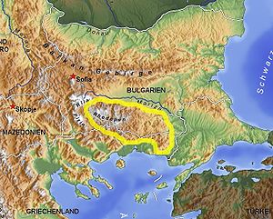
The Rhodope Mountains 83% are in Bulgaria and 17% in Greece.
Regions
The Rhodope Mountains are a mountainous landscape in the border area between Bulgaria and Greece. In the eastern Rhodopes, beech and oak forests are predominant, while in the higher western Rhodopes coniferous forests (this is also where the highest peaks are located). On the Bulgarian side, the significantly higher one closes in the northwest Rila Mountains, in the southwest the higher one Pirin Mountains at. On the Greek side are the Rodopi Mountain Range National Park and the Dadia National Park.
places


In Bulgaria
- 1 Batak. popular resort. New tourist complexes and private villas are constantly emerging on the banks of the dams, where thousands of tourists, mostly Bulgarian ones, spend their holidays every year.
- 3 Devin. The health resort Dewin (Bulgaria) is particularly famous for its mineral springs, but also offers a wide range of summer activities such as hiking, horse riding, mountain biking.
- 5 Momchilovtsi. A ski area in a wooded area of the Rhodope Mountains at 1,352 m above sea level. The place is particularly known in China for its good yogurt, which is said to have a life-prolonging effect, so that the remote area attracts many Chinese tourists.
- 6 Pamporovo. One of the most popular ski resorts in Bulgaria, known for its wooded surroundings.
- 7 Shiroka Laka. A small village known for its old Bulgarian architecture and for its musical tradition which has been maintained by a number of contemporary artists.
- 11 Kovachevitsa. The picturesque traditional architectural style has not changed since the village was founded. The only building materials used are stone and wood. Time and again, Kovachevitza served as a natural historical stage for the shooting of numerous films. In 1977 the village was declared a national architectural and historical site.
- 12 Leshten. Typical Bulgarian village high in the Pirin Mountains. All houses in the village are built in the old, typical Bulgarian architectural style and are heavily developed for tourism with many hotels and restaurants.
In Greece
- 15 Stavroupoli. is one of the largest and most important of the villages on the Nestos River near the National parks of East Macedonia and Thrace.
- 16 Paranesti. The village is a good starting point for the waterfalls and thermal springs in the area, the Nestos reservoir and the starting point for Mountain hikes.
background
The entire region is only sparsely populated, sometimes even unpopulated, and the road network is poorly developed. Because of the unique nature and the seclusion with steep hills and deep forests, it is a popular travel destination for nature lovers. In summer the area is popular for hiking and touring caves, waterfalls and cultural sites, while in winter skiers make up the majority of the guests. Another special feature of the region are the many ancient places of worship Thracian.
language
In the Bulgarian part of the Rhodope Mountains, communication is often difficult, especially because signposts, information boards, menus etc. are usually only written in Cyrillic. It is advisable to familiarize yourself with the Cyrillic alphabet, see Bulgarian phrasebook. Few people speak English or German. In the Greek part of the Rhodope Mountains, communication is much easier. Many speak German or English, and signposts are always in Latin letters.
getting there
The only sensible way to get there is by car. 4WD is usually not necessary, but makes driving on the often poor roads easier, especially when you are away from the main sights. One can like the area as a day tour from the beaches of the Greek tourist areas Chalkidiki or Kavala, Thasos achieve, but you should at least plan an overnight stay. Rental cars are not allowed to cross the border, so that you can only explore the attractions of the respective country.
mobility
Without your own vehicle, the area can hardly be explored and preferably with a 4WD if you want to be away from the main roads. Local public transport is only available between the localities.
Tourist Attractions
In Bulgaria


.jpg/406px-Smolyan_Province_-_Borino_Municipality_-_Village_of_Yagodina_-_Buynovsko_Gorge_(4).jpg)


.jpg/225px-Ecopath_``Waterfalls_canyon``_in_Rhodopa_Mountain_Smolyan_Bulgaria_(9912978046).jpg)
.jpg/400px-Ecopath_``Waterfalls_canyon``_in_Rhodopa_Mountain_Smolyan_Bulgaria_(9913512045).jpg)


.jpg/500px-Bulgaria_-_Kardzhali_Province_-_Dzhebel_Municipality_-_Village_of_Ustren_-_Ustra_(33).jpg)


caves

- 2 Yagodina cave. A spectacular cave, the third longest cave in the country, ranked 89th among the main tourist attractions in Bulgaria. The part of the cave with its beautiful stalactites and stalagmites that is open to tourism is 1100 m long and is electrically lit. The tours last about 45 minutes and take place every hour. Not far from the Yagodina cave there is a "natural bridge", and near the bridge is the beautiful waterfall "Praskolo".
- 3 Haramiiska cave. Not an easy to reach cave, but well worth seeing, which can only be reached by climbing. Huge cave the size of a stadium. Not recommended for people without basic knowledge of climbing and sports.
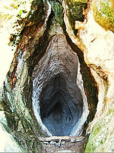
- 4 Devil’s Throat Cave (Devil's Throat Cave).


 in the Wikidata database") The cave, known as Devil's Throat and can only be entered with a guide, leads up a staircase next to a 42 m high waterfall. The path to the cave itself is beautiful. The cave has a single huge hall (for tourists), but it is full of underground waterfalls, rivers and basins. The legends surrounding this place are also very interesting. It is said that anything that falls into the river that flows into the cave never comes out at the other end (hence the name - Devil's Throat). During the Ottoman occupation, people who disobeyed the Ottoman religion or rules were thrown into the river of the cave.
The cave, known as Devil's Throat and can only be entered with a guide, leads up a staircase next to a 42 m high waterfall. The path to the cave itself is beautiful. The cave has a single huge hall (for tourists), but it is full of underground waterfalls, rivers and basins. The legends surrounding this place are also very interesting. It is said that anything that falls into the river that flows into the cave never comes out at the other end (hence the name - Devil's Throat). During the Ottoman occupation, people who disobeyed the Ottoman religion or rules were thrown into the river of the cave.


- 6 Golibovitsa Cave & Garga Dere Way. The cave is located 3 km south of Uhlovitsa Cave, off the road between Smolyan and Mogilitsa and is only accessible by boat as the first 25 m is completely underwater. After that, walk in the lantern light. Special equipment and a guide are essential. Information is available at the Smolyan Tourist Office. The Garga Gulley is a 140 meter long adventurous via ferrata along a cliff leading to a zip-line (zip line). This is a metal cable that stretches between the two banks of the Elenska and carries courageous tourists around 20 meters above the water.
- 7 Sharenka cave..relatively small cave that was inhabited during the Bronze Age (16-12 centuries BC).
Special landscapes
- 1 Trigrad Gorge. An imposing gorge at its end, the Trigrad River flows into the "Devil's Cave", where, according to Greek mythology, according to Orpheus, the legendary Thracian singer, tried to bring his beloved Euridice back from the underworld.
- 2 Buynovo gorge. The Buynovo Gorge is the longest gorge in Bulgaria. The Buynovo River flows here through the marble rocks and, through its erosion, has created this gorge. It is located between the villages of Yagodina and Teshel. The cliffs on either side of the gorge are hundreds of meters high and can be reached on foot or by car on a paved narrow road along the cliffs. Since traffic is two-way, patience is often required. For a good view of the Buynovo Gorge, it is worth visiting the “eagle's-eye view point,” a metal platform that was built at an altitude of 1,563 meters on the top of St. Iliya summit offers an impressive view of the entire region.
- 3 The rock bridges (Marvelous Bridges).(Marvelous Bridges, Chudnite mostove) - Magnificent natural arches in the rock, formed by the erosive activity of the Erkyupryia River, form the well-known and very photogenic bridges. The larger one (upstream, 45 m high) is formed by three arched arches and is accessible under the vaults. The river flows under the medium-sized arch. The smaller bridge (200 m downstream, 30 m high) is impassable. The place can be reached via an asphalt road from the village of Chepelare.

- 4 Canyon of Waterfalls. 46 smaller waterfalls form the canyon of waterfalls. The tour takes about 3-4 hours, depending on your physical condition. It's not particularly difficult, but neither is it easy. Sometimes it's steep uphill, but you don't have to climb. Those who have no health problems can go the way. The waterfalls themselves are not really spectacular, but the view from the panorama point Eurike to Smolyan is worth seeing. The route could be better signposted in some places. The best way to get information is at the information center at the beginning of the forest path. It is recommended to visit the Canyon of the Falls in early summer when the water level is at its highest.
- 5 Smolyan waterfall. beautiful waterfall, which can be reached via a somewhat strenuous footpath.
- 6 Stone mushrooms (Stone mushrooms, Kamenni Gabi).The stone mushrooms are a rock phenomenon near the village of Beli Plast. They reach a height of approx. 2.5 - 3 m.
- 7 The petrified wedding.photogenic rock formation worth seeing.
- 8 Kameshnishki Falls. Beautiful waterfall. 30 minutes ascent. There is an eco trail to the waterfall.

_-_Зимзелен_-_Природна_забележителност_-_PZ132_No4.jpg/147px-Каменна_сватба_(Скални_гъби)_-_Зимзелен_-_Природна_забележителност_-_PZ132_No4.jpg)
Cultural assets
- 1 Devil's bridge (Дяволският мост).Nice place with old stone bridge over a river. A 3 km long path leads through a forest to the bridge. The view is great! Legend has it that the bridge was built by the Romans to connect the Aegean Sea and the Thrace region in Bulgaria. The bridge is the largest and most famous of its kind in the Rhodope Mountains,

- 2 Asen fortress (Φρούριο του Ασέν).About 6 km north of the village of Bachkovo is the Fortress of Asen, a medieval fortress on a high rock ridge on the left bank of the Asenitsa River. It is one of Bulgaria's most visited medieval attractions.

- 3 Ustra Fortress (Φρούριο Ούστρα).The fortress was built in the 10th century to protect an important trade route. It changed hands frequently, but the Byzantines held it most of the time. The walk to the fortress is quite difficult and takes about 1 hour, but the views from this fortress are breathtaking. The way to the fortress is long and a little difficult.

- 4 Momchil fortress. The fortress was built during the reign of Emperor Justinian I (527-565), who started massive military construction projects across the entire Balkan Peninsula. It was later burned down and rebuilt until it burned down again after the Ottoman invasion at the end of the 14th century and was never rebuilt. The trip is more worth the view than the ruins.
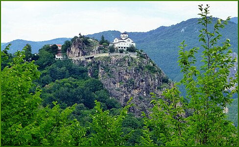
- 5 Kale Fortress. Interesting path with passage through a cave to the fortress walls. Nice view from there.
- 6 Open-air museum "Zlatograd"..Beautiful old town with unique architecture. They show various handicrafts in some of the old houses.
Monasteries
- 1 Roschen Monastery (Μονή Ροζινού).One of the most beautiful monasteries in the Balkans.
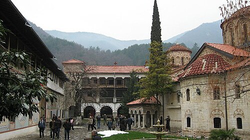
- 4 Bachkovo Monastery (Moναστήρι Μπάτσκοβο).A small hamlet in which the medieval, well-known monastery of the same name is located. The nearby "Вашхово" waterfall is worth seeing. It is a branched 10-meter-fall with many different watercourses on the banks of which benches and tables invite you to picnic.
- 5 Arapovo monastery.Nice country monastery with a very well-kept garden.
- 6 St. George Monastery. in Hadjidimovo. Large and well-kept monastery with a small church and beautiful gardens.
- 7 St. Panteleimon Monastery. small but very beautiful monastery complex. The begins at the monastery complex Nevystata Eco Trail. Its length is about 1 km. There is a gazebo, tables and benches. The path leads to the rock of the same name "Nevyastata". The ascent of the rock is quite steep but you have a wonderful view of the city of Smolyan. An alpine zip line and an artificial climbing wall have also been built above.
- 8 Ustrem monastery.Smaller monastery complex in a beautiful landscape.


Archaeological sites
.jpg/404px-Bulgaria_Blagoevgrad_Province_Garmen_Municipality_Garmen_Municipality_Landscape_Historical_Park_Gradishte_(10).jpg)


- 1 Gradishte Historic Landscape Park. The prehistoric settlement and Thracian sanctuary. This ancient temple dates back to the fifth millennium BC. According to archaeologists, it is one of the largest in Bulgaria and possibly in Europe. The sanctuary is located on a 700 m long ridge. In some places there are rock carvings of human profiles, animal figures, fish, turtles and birds.

- 3 The womb cave.The Vagina cavity (Cult complex "Utroba Cave" Тракийско светилище Пещера Утроба) is located near the village of Ilinica. The Thracian cult cave for fertility rites is shaped like the opening of a vagina and is 22 m deep and 2.5 m wide. Water is constantly seeping from the damp walls. At the end of the cave a carved altar (1.3 m high) symbolizes the uterus itself. At noon, when the sun reaches its highest point, the sunlight seeps into the cave through an opening in the ceiling and projects a clearly recognizable representation of a phallus on the ground. As the sun progresses and the light falls through the interior of the cave, the phallus becomes longer and then extends almost to the altar. Only during the months of the year when the sun is lowest on the horizon does the phallus become long enough to reach the altar and symbolically fertilize the womb. From Kardzhali you drive to the village of Dazhdovnitsa and about 11 km further to a sign indicating the beginning of the path to "The Womb". The hiking trail initially leads steeply uphill to a level ridge, where the first pavilion is located for relaxation before the actual ascent. A steep, winding path to walk for 15-20 minutes takes you to the second pavilion. On the already horizontal path you reach the third pavilion in front of the cave, which is much larger with tables and a barbecue. Today, childless couples often visit the uterine cavity in the hope of having a long-awaited child through the magic of the place of worship. A few kilometers from the path to the cave there are several hotels in the village of Glavatartsi and Dazhdovnitsa.
- 5 Hisarya. The Thracian cult site Hisarya is located on the Hisarya elevation in the Eastern Rhodope Mountains, near the village of Senoklas. The archaeological excavation area includes a Thracian cult center with a rock sanctuary, rock niches, rare rock suns and the ruins of a large Thracian and medieval fortress.


- 6 The Deaf Stones. The Deaf Stones Rock Sanctuary is one of the greatest Thracian cult monuments. It consists of several large boulders with deep chambers carved into them. A staircase leading to the summit has been carved into the boulder in the east. The remaining three rocky peaks are dotted with more than 200 religious cult stone niches.
- 7 Perperikon (Περπερικόν).An archaeological site with monumental megalithic structures that date from the Bronze Age and is considered the largest megalithic archaeological site in all of Bulgaria.

- 8 Tatul.The Thracian sanctuary is one of the most impressive megalithic monuments discovered on the territory of Bulgaria. The sanctuary is a massive rock structure and its top is a truncated pyramid. The complex consists of two sarcophagi, a rectangular bed for the main altar and a three meter deep well. It dates from the end of the 4th and beginning of the 5th century BC.

- 9 Fotinovo Turtles (Fotinovo turtles).Turtle-like reliefs cut into the rocks by an ancient culture. The largest is 7 x 5 m.

- 10 Thracian cult complex “Orlovi skali” (Orlovi Skali).Orlovi Skali (Eagle's Nest Sanctuary) is a historical Thracian site near Ardino and consists of niches cut into a large rock that overlooks the forest and was obviously of religious significance. This Thracian phenomenon, the "trapezoidal niches", can be found everywhere in the Rhodope Mountains, dug high into hard-to-reach rocks. There is no clear answer as to how or why the Thracian people made them. The Orlovi skali (Eagles' Rocks) The site has about 100 rock niches. From Ardino an asphalt road leads to a small parking lot at the beginning of a hiking trail. From there, the climb takes about 15 minutes to get to the rock.

- 11 Karadzhov stone (Karadzhov kamak).(Karadzhov Kamak) is an interesting rock phenomenon not far from the village of Mostovo. On a high rock plateau (1.448ml) a gaping joint has formed on its vertical walls, in which a huge stone is stuck, as if moved there by higher forces. This place has been special to the people since ancient times - the ancient Thracians built a sanctuary here to honor their dead. Small pits carved into the rock for religious purposes as well as steps leading to the upper part of the massif have been preserved to this day.

- 12 Belintash.The terrace at the summit of Belintash can be reached via stone steps. Niches, depressions and carved stone steps, which are supposed to be a replica of the heavenly bodies and constellations, can be seen. Ancient graves as well as Neolithic, late bronze and early iron ceramics have been found at the base of Belintash.

- 13 Thracian cult complex (Starosel) (Thracian Cult Complex (Starosel)).This site was only discovered in 2000 and includes a temple built into the mountaintop and a nearby burial site for a chief / king. Very interesting for people interested in archeology and Thracian culture! View from above is beautiful. The temple and the nearby residence of the Thracian king under Mount Kozi Gramadi probably date from the reign of Amatokos II (359-351 BC).

- 14 Thracian tumulus horizon (Thracian Tomb near Starosel).contains the only known Thracian temple with a Doric colonnade. It is one of ten tumuli that are within the local area of Starosel.
- 15 Maltepe..the Thracian burial mound Maltepe near Plovdiv (near the village of Manole) is the largest of its kind in Europe with a height of more than 24 meters.
- 16 Cromlech stone circle (Cromlech at Dolni Glawanak).The Dolni Glavanak Cromlech is an oval stone circle. The site is called Cromlech by analogy with similar monuments in Western Europe, but it is the only known structure of its kind in the country.


In Greece


caves
- 8 Maras Cave. Limestone cave in beautiful surroundings and only with stalactites, but no stalagmites due to an underground river.
- 9 Alistrati Cave (Σπήλαιο Αλιστράτης).one of the most beautiful stalactite caves in Greece with regular guided tours.
Special landscapes
- 9 Ag.Barbara waterfall and lake. A small lake is located 600m from the road with a waterfall in the middle of the forest. Benches and tables land to rest and the lake to a dip in the cold water. From the main road, turn off at a sign and follow the gravel path for approx. 300 m to the parking lot. There you cross the small river over a bridge made of tree trunks. The waterfall is about 500 m inland near an animal shelter. The waterfall is not located on the river that you had to cross, but in the forest!
- 10 Lepidas waterfall. A picturesque waterfall near the village of Dipotama 700m walk from the dirt road.
- 11 Loutra Thermion. Hot thermal springs of 80 ° C. You can take a hot bath in illegally built, slum-like corrugated iron huts, some of which are open.
- 12 Livaditis waterfall. A picturesque waterfall near the village of Levaditis with 3 pools invites you to relax in the water. The waterfall is well signposted once you reach the village of Livaditis. After leaving the village you drive another 3.5 km on an asphalt road. Then you reach a larger parking lot, from which a 2.2 km long gravel road leads to a small shelter. Without all-wheel drive, the dirt road should be used with caution. From there, a beautiful, well-signposted 2 km long hiking trail leads downhill through the forest to the waterfall. Plenty of water is also available in summer for a cool bath.
- 13 Nestos Gorge (Nestos Delta National Park and Vistonida-Ismarida Lakes).youtube url used
 at Toxotes is of particular natural beauty. The Nestos River meanders through the limestone mountains and formed a unique landscape. A 10 km long hiking trail leads along the gorge along high cliffs with beautiful views of the river. In the hot summer, it is a pleasure to take a refreshing dip in the freezing cold river.

- 14 Thracian Μeteora. Interesting rock formation reminiscent of a mini version of the famous Meteora rocks near Kalambaka. It is surrounded by abandoned settlements. Access by car on a dirt road (15km).
Cultural assets
- 7 Stone bridge over the Kompsatos river. A stone bridge well worth seeing.
- 8 Fort Rupel (Ρούπελ).Fort Roupel (Greek: Οχρό Ρούπελ) is a fortress on Greece's northern border, built in 1914. It became part of the fortifications of the Metaxas Line in the 1930s and became famous for its defense during the German invasion of Greece in April 1941.
- 9 Paliou Filakiou old stone bridge. located near the village of Dipotama in the forest. About 50m away is the lovely little chapel of the Holy Spirit.

Monasteries
- 9 Metamorfosis Sotiros Monastery. The monastery is definitely worth a visit, especially because of its very scenic location. It is next to the village of Prasinada.
Archaeological sites
- 18 Macedonian tomb at Stavroupoli. A small but well-preserved Macedonian grave from the first half of the 4th century BC. Chr.
- 19 Macedonian tomb of Elafochori (Μακεδονικός τάφος Ελαφοχωρίου)

activities
- To ski: There are several ski resorts, of which Bansko is the best developed.
- hike: A famous annual marathon takes place in Paranesti.
- swim: Good places for a refreshing swim in the hot summer are the Nestos River and the many lakes and waterfalls.
- SPA: A large number of health resorts and thermal springs offer ideal conditions.
Thermal springs in Bulgaria:
- 1 Velingrad (Βέλινγκραντ)

- 2 Ognyanovo.Known for centuries for its mineral springs and a popular spa destination with many hotels and guest houses. The Miroto bathroom is freely accessible at any time and also at night.

- 3 Devin
 (Dewin). Not only is Devin known for its spa qualities, it's a base for some of Bulgaria's best hiking and exploration tours. Right on the outskirts, next to the thermal baths, is the Devin Eco Walk, a beautiful 7 km long path that runs along the river past waterfalls and through canyons.

- 4 Sapareva Banya (Saparewa Banya).
 There are many places in the city where you can enjoy the healing thermal water - both in hotels with their own pools and in a public spa with pools. One attraction is a hot geyser, where the water exits at more than 100 degrees.
- 6 Varvara. There are 2 hot outdoor pools there - in the Varvara Complex and another in the Aqua Varvara Hotel.
- 7 Banya. the place has numerous mineral springs and almost every hotel offers mineral water in beautiful surroundings. Hot mineral water flows from several wells in the village.
Thermal springs in Greece
- 9 Nigrita
- 10 Siderokastro
- 11 Agkistro
- 12 Loutra Elefteron. The springs are in dilapidated ruins and in the open. Nice surroundings but not a safe place as drug addicts live in the ruins there. Still popular and often visited.
- 13 Thermia at Paranesti. There are no special facilities in thermal springs, only natural baths in dirty, homemade corrugated iron huts, but in a scenic setting. The springs are so hot that you can hardly bathe in them if the water is freshly let into the basin.
kitchen
- Patetnikat is a typical potato dish. Peel and grate the potatoes, add (sheep) cheese, butter, eggs, onions, mint, salt, pepper and mix well. Fry the mixture on both sides in the pan or bake in the oven. Serve garnished with yogurt. It is similar to the German potato pancake.
- Rhodopski clin (Rhodope style banitza) - A mixture of beaten eggs, sheep cheese (siren), rice, parsley, well salted and sandwiched between thick puff pastry or pasta dough and baked in an oven for about 20 to 30 minutes. The same recipe in Greece is called pitta.
- Parlenka: Bread yeast dough is rolled out like a pizza dough and then fried in the pan and finally topped with slices of mountain cheese and waited until it has melted, then served.
nightlife
A noteworthy nightlife is limited to the larger towns and cities. In the extensive natural landscapes with small villages, the offer is correspondingly low.
security
The area is very safe in terms of crime and the only real danger is the wild nature with steep slopes, lonely forests where an injured hiker cannot be found immediately. It is a good idea to let someone know if you want to go on a remote hiking trail. The reception of the cellular network is not always good enough to call for help.
climate
The location of the Rhodope Mountains in the southeastern part of the Balkan Peninsula also determines the climate. It is characterized by a transitional climate, as it is influenced by both the colder northern air masses and the warm breezes of the Mediterranean (Aegean). The annual average temperature of the Eastern Rhodope Mountains is higher and more stable and moves around 12 ° - 13 ° C. In the Western Rhodope Mountains - under the influence of higher altitude above sea level - the average temperature ranges from 5 ° - 9 ° C. The transitional climate in the Rhodope Mountains is also noticeable through the annual course of precipitation. In the Eastern Rhodope Mountains, the peak of rainfall is in December and is minimal in August. In the western Rhodopes it is the other way round, where summer rainfall prevails. The mild climate combined with other factors favors the development of recreation and tourism. One example is the "Pamporovo" resort, where the microclimate allows the snow cover to be maintained until late spring - a true paradise for skiers.
literature
- In the lap of the Rhodope Mountains. Wanderings through Bulgaria, 1982, by Iwan Wasow
- The Rhodope mountain tour guides, 1977
- Bulgaria - From the Rhodope Mountains to SofiaFebruary, 1998, S.Müller-Hanpft and M. Bosboom
- Eastern Rhodopes: Nestos, Evros and Dadia - Bulgaria and Greece (Crossbill Guides, Volume 14)
Web links
Film about Rhodope Mountains, Bulgaria