| Sakhalin | |
 | |
Location .svg/250px-Sakhalin_in_Russia_(claimed).svg.png) | |
| State | Russia |
|---|---|
| Region | Eastern Russia |
| Capital | Južno-Sachalinsk |
| Surface | 87 101 km² |
| Inhabitants | 488.308 (2015 estimate) |
| Tourism site | |
| Institutional website | |
Sakhalin (also transliterated as Sakhalin or Sahalin, in Russian: Сахалин) is an island region in the North Pacific Ocean. Together with the Kuril Islands form theSakhalin Oblast of the Russia.
To know
The name of the island derives from a misinterpretation of the Manchu expression sahaliyan ula angga hada (ie "peak of the mouth of the Amur River"). In the Manchu language sahaliyan means "black", referring to the Amur river (sahaliyan ula). The Ainu name of the island is Karafuto (樺 太) or Krafuto; it was restored at the time of the rule of the Japanese Empire on the southern part of Sakhalin between 1905 and 1945.
Geographical notes

The island of Sakhalin is located a short distance from the Asian mainland, from which it is separated by the Strait of Tartars which, in its northern part, narrows up to about 7 kilometers. To the south, the strait of La Pérouse separates it from the Japanese island of Hokkaidō. The northernmost point of the island is Cape Elizaveta on the Schmidt Peninsula, and Cape Crillon is the southernmost point. Cape Terpenija, at the end of the peninsula of the same name, is the easternmost point, while Cape Aniva is located at the end of the Tonino-Anivskij peninsula in the south-eastern part. The major coves are the Terpenija gulf to the south-east and the Aniva gulf to the south.
The island's territory is mainly mountainous, with the exception of the northern area where the northern lowland opens up, the only flat area of a certain extent. The major mountains are the Western Range, the Eastern Range and the Susunaj Mountains. In the Eastern Range is Mount Lopatin (1609 m), the island's highest elevation. Due to the proximity of the watersheds to the coast, there are no major rivers on the 'island; the most important are the Poronaj and the Tym '.
When to go
In Sakhalin there are very cold winters, with variable thermal averages, in January (generally the coldest) between −18 ° C and −25 ° C in the north and between −6 ° C and −12 ° C in the south ; temperatures rise very slowly, due to the maritime environment, so much so that spring is very late and the hottest month of the year is generally August, when average temperatures are between 11 ° C and 16 ° C in the north and between 16 ° C and 20 ° C in the south. Atmospheric precipitations, contrary to what happens in more continental areas, are not lacking, and become locally abundant; precipitation falls in snow form for several months of the year and large accumulations can be observed.
If you are not used to the harsh cold, you should definitely visit Sakhalin in the summer.
Background
Indigenous peoples have inhabited the island for several centuries, making a living from fishing and farming and passing under the control of China and Japan. A clear impetus to the colonization of the island was given by the Russian Empire which annexed the territory, transforming it into its own province. Clashes with Japan for control of the region continued over the decades. At first, Russia transformed the island into a place of deportation and imprisonment, effectively blocking its development. A trend that ended at the beginning of the twentieth century and that with the declaration of free land for voluntary population and with the exemption from the military service of the settlers, the times of development were very rapid. In 1904/1905 after the war between Japan and Russia and with the defeat of the latter, the southern part of the island passed under the dominion of the rising sun. This situation remained unchanged until the last days of the Second World War, when in August 1945 the USSR attacked Manchuria and the southern part of Sakhalin, occupying them in a few days; so when the signing of the capitulation broke up the Japanese empire on 2 September 1945, the southern part of Sahalin had already returned to Russia. distribution of the local population. An earthquake with catastrophic results hit the region in 1995 and with its more than 7 degrees of intensity caused over 2000 deaths. At the end of February 2006, a strange fact attracted attention again; a blanket of yellow snow with a strong smell of oil covered the city of Sabo, now inhabited only by oil industry workers
Spoken languages
Apart from the Russian which is the official language, many minority languages are spoken on the island, among which the Japanese in the border areas with Japan and in the capital.
Suggested readings
Anton Chekhov, the famous Russian writer of the nineteenth century, volunteered to go to Sakhalin for the census and for the occasion composed a detailed description of life in Sakhalin in the late nineteenth century which was then merged into his documentary story "The island of Sakhalin ". At that time the island was one of the main places of exile for political prisoners. It was these communities of deportees that populated the island and began the demographic development that it saw throughout the twentieth century.
Other important more recent writers such as Vlas Doroševič and Valentin Pikul 'wrote, years later, about the Russo-Japanese war that was fought in these territories. Their books are still an excellent source for understanding this region.
Territories and tourist destinations
.png/400px-Sakhalin_map_(it).png)
Urban centers
- Aleksandrovsk-Sachalinsky (Александровск-Сахалинский) - Chekhov lived here during his stay in Sakhalin; after the capital it is the most important city.
- Cholmsk (Холмск)
- Južno-Sachalinsk (Южно-Сахалинск) - Capital of the island and the most developed city on the island.
- Korsakov (Корсаков) - Port city in the south of the island.
- Makarov (Макаров)
- Nogliki (Ноглики) - Important center for oil extraction.
- Ocha (Оха)
- Uglegorsk (Углегорск) - City famous for its stone mining industries.
How to get
Sakhalin Island
There are no railway connections or bridges between the mainland and Sakhalin; they were started in the 40s but the works were suspended with the death of Stalin. Today there are almost exclusively connections by sea and "by sky"; In winter there is also the possibility of crossing the canals using the frozen sea as a road even if the undertaking is quite dangerous due to the sudden and frequent rains that can melt the ice layer.
Sakhalin is however not in the Pogranzona (short for "pograničnaja area"), that is, in the border areas with non-allied countries; this means that, transport and bears danger permitting, you can travel with a passport with a valid visa. Non-Russian citizens must also pass an additional check and register at the offices of border.
Minor islands
- Police of the Pogranzona of Sakhalin (Сахалинское пограничное управление береговой охраны), prospekt Pobeda 63a, ☎ 7 4242 49 20 62, fax: 7 4242 42 32 59. The islands close to the main one of Sakhalin are - for whatever reason - border land and therefore it will be very difficult to enter. If you really intend to request the pass, you can forward it to the competent office, strictly in Russian. It is very difficult to request it on your own, preferably contact a travel agency that will do everything for you.
By plane
Although Sakhalin is not a very populated island, air traffic is very developed here and represents the main way used by the inhabitants of the island to reach the mainland.
- Južno-Sakhalinsk Airport. It is the main airport, located in the capital. Flights arrive here from all over Russia, from Japan and from China.
In addition to this, which is the largest, there are many other minor airports including another widely used one in the town of Ocha. Most of these small airports only have local flights between the nearby mainland cities and Sakhalin.
There are few travelers who reach Sakhalin by sea and mostly those who do, do it to experience the feeling - as the Russians say - of a "long and difficult journey to the edge of the globe". Voyages by ship, far from cutting edge, are often turbulent and dangerous due to weather conditions and the presence or absence of ice.
For the more adventurous, it is worth knowing that the following routes exist all year round:
- Vanino - Cholmsk; (up to Vanino you can get there with numerous trains from all over Russia)
- Lazarev - Pogibi; it is an unofficial but very famous route active from May to October, extending a few kilometers in the Nevel'sky Strait. Lazarev can only be reached by own means or by hitchhiking and this has made this route one of the most favored by adventure tourism. The crossing takes place on "kater", a kind of jet ski.
How to get around
What see
The best part of Sakhalin is definitely the nature. The cities here are relatively young and unattractive, so visitors just have to admire the ethnographic peculiarities of this land.
- Mount Vajda (Гора Вайда). It is the highest point of the mountain range in the center of the island. This mountain no higher than one kilometer in height represents the place where karst phenomena acted with greater intensity, giving rise to unusual caves and reliefs. The most interesting are the Vajdinskaja cave, with picturesque stalactites and stalagmites, and the "Cave of the Tragedies of the Bears", in which bear bones and very ancient tools were found. The surface is covered with meadows and mountain lakes. In the first half of the twentieth century the mountain was located on the border between the Russian part of the island and the Japanese one. The nearest inhabited center is the Izvestkovyj village, connected by a road (but not by public transport) with the Smirnye railway station. Admission to the caves is free, but it is best not to go there without a guide or a guided tour.
- Cholmsk - Južno-Sachalinsk railway line (Железная дорога Холмск - Южно-Сахалинск). Built by the Japanese in the 1920s, it connected the west coast of the island to the east. The reliefs on the island made it necessary to build a whole series of tunnels and bridges. However in 1993 the train traffic was interrupted, due to the poor conditions of some sections of the railway, but it is still possible to walk the entire route and admire what remains of the railway and the wonders of the surrounding nature. The line is 85 km long and takes two days to travel, but you can also choose a shorter route, which goes from Nikolajčuk station (local trains from Cholmsk) to the village Čaplanovo. During the walk along the abandoned railway one must be careful because the old bridges are not always safe to cross. It is also advisable to bring a torch with you when crossing the tunnels.
- Chief Kril'on (Мыс Крильон). It is the southern tip of the island. It can be reached from the village Šebunino, with a maršrutka from Nevel'sk. The rest of the route (more than 70 km) proceeds along the beach and can only be covered by off-road vehicles. The traveler will have the opportunity to admire the suggestive landscapes (on one side the mountains and on the other the sea), as well as the local fauna. At the tip stands the lighthouse built at the end of the 19th century and a weather station.
- Tunajča lake (Озеро Тунайча). It is located 45 km from Južno-Sachalinsk and it is the largest lake on the island and a destination of attraction for ornithologists or simple lovers of uncontaminated nature. It can be reached by maršrutka to Svobodnaja or Ochotskoe, or by booking a vehicle at a tourist agency.

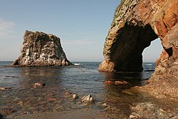
- Moneron Island (Остров Монерон). It is located southeast of Cholmsk. Despite its surface of over 30 km2, the island remained uninhabited for a long time, except for sporadic expeditions by biologists and ornithologists. The main attraction of the island is the underwater fauna, which, thanks to the warm currents, can even boast the presence of subtropical molluscs. Visibility underwater often reaches 30-40 m and thus allows diving. No less beautiful is the mainland, with its rocks, deep canyons, beautiful waterfalls and green meadows. Moneron Island and adjacent islands are inhabited by small bird colonies, as well as seals and sea lions. You can get there by helicopter or by boat. The territory of the island is a national park, however the infrastructure for an autonomous tourist activity is still lacking: all the excursions are in fact managed by local tourist agencies, while the dives are organized by the «Sachalin diving club»[link not working].

- Tjulenij Island (Остров Тюлений), ☎ 7 4242 48 68 89. Small rocky island in the Sea of Okhotsk, 12 km southwest of Cape Terpenie. This protected area is home to a large number of seals and seabirds. It is not possible to visit the island independently but it is necessary to contact the local "Cooperation Center for the development of tourism" (Центр содействия развитию туризма).
- Ždanko Mountains (Хребет Жданко). Picturesque mountain range of volcanic origin north of Tomar 'and the village of Tichaja, stretches for 13 km. You can get there by postal train Južno-Sachalinsk - Tymovsk, which arrives at Tichaja station around noon. These mountains are particularly beautiful in spring, when patches of vegetation begin to sprout on the cliffs. It is possible to travel the entire length of the mountain range with hikes lasting 2-3 days.