 Safed old town | ||
| Safed, Zefat, Sfat, Tzfat, Tsefat | ||
| district | Northern District | |
|---|---|---|
| Residents | 33.358 (2015), 2.317 (1948), 4.000 (1949), 5.500 (1950), 7.000 (1951), 7.750 (1952), 7.900 (1953), 8.100 (1954), 8.800 (1955), 9.800 (1956), 10.050 (1957), 10.150 (1958), 10.500 (1959), 10.700 (1960), 10.710 (1961), 10.950 (1961), 11.500 (1962), 12.300 (1963), 12.700 (1964), 12.900 (1965), 12.900 (1966), 13.000 (1967), 13.100 (1968), 13.100 (1969), 13.100 (1970), 13.200 (1971), 13.600 (1972), 14.400 (1973), 14.300 (1974), 14.200 (1975), 14.200 (1976), 14.600 (1977), 14.900 (1978), 15.500 (1979), 16.100 (1980), 16.500 (1981), 16.900 (1982), 15.900 (1983), 17.200 (1984), 16.800 (1985), 16.800 (1986), 16.400 (1987), 16.400 (1988), 16.600 (1989), 19.300 (1990), 21.400 (1991), 20.900 (1992), 21.200 (1993), 21.600 (1994), 21.959 (1995), 22.979 (1996), 23.762 (1997), 23.991 (1998), 24.300 (1999), 25.157 (2000), 25.904 (2001), 26.400 (2002), 26.800 (2003), 27.300 (2004), 28.200 (2005), 28.100 (2006), 28.500 (2007), 29.600 (2008), 29.500 (2009), 30.400 (2010), 32.200 (2011), 32.100 (2012), 32.900 (2013), 32.900 (2014), 33.400 (2015), 33.600 (2016), 35.300 (2017), 35.700 (2018) | |
| no tourist info on Wikidata: | ||
| location | ||
| ||
Safed or Zefat (Hebrew צפת Tsefat, Arabic صفد Safad) is a city in Upper Galilee in the northern Israel. The city is known as one of the historic centers of Jewish learning. The city's artists' colony is also interesting.
background

Safed is about 35 km northwest of Tiberias on a mountain range in the mountains of the Upper Galilee.
Safed could be considered the location of the place mentioned by the Jewish - Roman historian Flavius Josephus Sapph can be identified, in the time of the Second Temple there was a vigil, with bonfires the dates of the new moon and the festivals in the temple in Jerusalem were signaled into the country. Nothing is known about the fate of the city from the early Muslim period.
The town Sapphet was conquered by the crusaders in 1099 and a crusader castle was built on the citadel in 1102. After the Battle of Hattin, the citadel was conquered by the Muslims in 1188 from the Ajjubids under Saladin, briefly came under the rule of the Templars again from 1240 to 1266, and was conquered by the Mamluks under Sultan Baybar and not razed due to its strategic value. Public buildings, a caravanserai were built and the church was converted into a mosque; Jews could remain in the city in small numbers.
When all Jews had to leave the country after the Reconquista in Spain in 1492, large numbers were allowed to settle here. The immigration of prominent rabbis created a center of the mystical form of the Jewish religion in Safed, known as Kabbalah is known. Around 1550 Safed had more than 10,000 Jewish inhabitants. The first Hebrew book was printed here in 1577 and at the end of the 16th century. there were 32 synagogues. In the 17th century the city came under the rule of the Druze and again the Ottomans, pogroms and looting, destruction by earthquakes and plague trains decimated the Jewish population again and again; Moses Montefiori visited the city in the 19th century. and contributed financially to the reconstruction.
During the British mandate, a third of the 8,800 residents in 1922 were Jewish. The Olei HaGardom staircase was built because of the recurring conflicts between the Jewish and Arab residents and after the Kassacre of twenty Jews in 1929, a watchtower with spotlights at the top guarded the staircase as a border line between the Arab and Jewish quarters. In 1948 there were just 1,700 Jews living in Safed, compared to over 12,000 Arabs. The Jewish population faced repeated attacks when the British withdrew from the city on April 16, 1948, the Jewish quarter was targeted by local militias and the Arab Liberation Army. The 200 Haganah fighters at the citadel were supported by units of the Palmach, under artillery fire the Israeli units were able to occupy the citadel and the British police fort on the hill north of the city as part of Operation Yiftah. Under the command of the Arab troops, the Arab resident population was evacuated from Safed; it was assumed that they would return to the residential areas quickly after the annihilation of the Jewish enemy. Because the Israeli units were able to stay in the young state of Israel, the morale of the Arab troops was badly damaged and the Arab resident population was expelled to Lebanon and Haifa.
getting there
By plane
Visitors typically travel through the international airport Ben Gurion Airport of Tel Aviv one, an airfield near by Rosh Pina is occasionally used for regional traffic.
By train / bus
Upper Galilee is not accessible by rail. the nearest railway station is that of Nahariya on the Mediterranean coast. There are regular bus connections between Safed and the larger cities in the region, including with Tiberias. The 1 Bus station is to the west of the hill of the citadel.
In the street
Safed is on the road89that in the west at Nahariya begins and in the east at Rosh Pina on the important north-south connection of the road90 meets.
To get into the place, you either take the 2 Junction from the street 89, which winds its way up the ridge to the old town in serpentines (the navigation device helps to follow the course of the road), or the access via the 3 Street 8900 from the north. That the city is on the street signs sometimes as Safed and sometimes as Zefat is signposted, makes the journey only a little difficult.
There are few parking spaces in the old city center, best of all 4 parks one in front of the Wolfson Center / Saraya or on the small one 5 parking spot in the south of the old town, this itself is not accessible by private car.
mobility

Safed is located on a ridge, on the highest point there was once the crusader fortress on the citadel. The old town on the south-western slope is practically only accessible on foot, numerous stairs connect one street level to the next. The most important is that 6 Ma'alot Olei HaGardom, which separates the Jewish old town from the former Arab quarter with the artists' colony and from which one can reach the most important sights. Larger parts of the old town are free of traffic, but only partially wheelchair accessible due to the stairs (![]() ).
).
Local buses drive to the residential areas, but circle the actual old town.
Tourist Attractions


.jpg/220px-Ha'Ari_Ashkenazi_Synagogue_(3301187009).jpg)
A good starting point is that 1 Seraya, the fortified Ottoman governor's seat, which was built at the beginning of the 18th century. was built; there are parking spaces nearby and that 1 Post office. HaPalmach Street leads to the 7 Jerusalem Street, the shopping street and promenade of the town.
A staircase leads to the top of the hill with the 2 citadel, which rises above Safed and from which a beautiful panoramic view is possible. A cistern on the top of the citadel and various ruins and remains of vaults have been preserved. A park was set up in the grove to the north.
The staircase of the leads from Jerusalem St. Ma'alot Olei HaGardom down, the stairs were built under the British mandate to separate the Jewish and Arab quarters, guards were posted on the stairs, at the top there is still a tower with loopholes and a large spotlight.
To the north extends the Jewish old town, the 8 Beit Yossef Alley is a traffic-free alley lined with galleries, shops selling Judaica, snack bars and synagogues.
The various synagogues are mainly visited by Jewish guests, but they are also often open to other visitors; a hat is to be worn and a small donation is welcome when leaving.
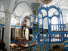
- 3 Ari Ashkenazi Synagogue. Open: Open on weekdays.
- 4 Ari Sephardi Synagogue. Possibly the oldest synagogue in the city, only open for prayer on Shabbat.
- 5 Abuhav synagogue. Built around 1490 under Kabbalistic architectural principles.
- 6 Yosef Karo Synagogue. Built in the 16th century. at the place of a Torah school (Jeshiva) of Rabbi Yosef Karom who wrote the law Shulchan Aruch.
The Arab quarter used to be to the south of the Ma'alot Olei HaGardom staircase; After the Israeli War of Independence and the expulsion of the Arab population, the old buildings were revitalized and artists founded the artists' colony here.
- 7 General Exhibition: an art exhibition has been set up in the former mosque of the Arab quarter. In this group exhibition works by a large number of artists who work in Safed are exhibited, each participant of the group exhibition can present himself with some works, in addition temporary exhibitions are shown.
- Opposite the courtyard, works by local artists are also exhibited and can be purchased in a number of small galleries.
- A central one 8 place invites you to performances and events.
- Rabbi Isaac Luria (the "Arizal"), the famous Kabbalist from the 16th century.
- Rabbi Joseph Karo, the author of the Shulchan Aruch Jewish law.
- Rabbi Moshe Cordevero (the Ramak), a Kabbalist who preceded Arizal.
- Chana her seven sons, the martyr family from the time of the temple.
11 Ari Mikwah, an immersion bath (mikveh) facility that has been in use for centuries.

activities

- Visit of the old Jewish quarter with its synagogues
- Visit to the citadel, from the top of the hill there is a beautiful view in the direction of Tiberias and Upper Galilee.
- Every mid-August takes place in Safed Klezmer Music Festival instead that brings friends to Jewish music to the place.
shop
- The old Jewish quarter mainly offers Judaica, jewelry, objets d'art and works of art.
- In the artists' colony around the former Arab quarter and in the joint exhibition in the former main mosque, numerous works of art can be acquired, from simple prints and drawings to large-format oil paintings and sculptures.
kitchen
Various restaurants and fast food outlets can be found in the modern shopping street on Jerusalem St.
nightlife
accommodation
security
health
- the hospital 1 Ziv Medical Center has an emergency room.
Practical advice
trips
literature
Web links
- www.safed.co.il, website with tourism information, engl.
- http://www.zefat.muni.il/Pages/default.aspx - Official website of Safed, Heb.