| Saijō ((ja)西 条) | |
| Information | |
| Country | |
|---|---|
| Region | Shikoku |
| Area | 509,88 km² |
| Population | 103 760 hab. () |
| Density | 203,5 inhab./km² |
| Spindle | UTC 09:00 |
| Location | |
 33 ° 52 ′ 30 ″ N 133 ° 9 ′ 13 ″ E | |
| Official site | |
Saijō, also known asIyo-Saijō (伊 予 西 条), is a city of the prefecture ofEhime, on the island of Shikoku to Japan.
Understand

Saijō is a medium-sized town in Ehime Prefecture, known throughout Shikoku for its spring water (uchinuki), its major autumn festivals and for being the gateway to Mount Ishizuchi, the highest peak in western Japan. The municipal area is home to temples 60 to 64 of the Shikoku Pilgrimage. This municipality was formed by the merger of the ancient city of Saijō and the cities of Tōyo, Komatsu and Tanbara in 2004.
Saijō is rather off the beaten track. It is, however, a good place to sample Ehime's relaxed and hospitable culture. Many of the usually conservative and polite locals exhibit a wild, festive character during the annual fall festivals of Saijō, Komatsu, Tōyo, Himi and Iwane. With proper preparation, you can find specialty shops, restaurants and izakayas with local produce. For nature lovers, the hiking season can be a great time to come, except for the scorching heat in August. You can also see beautiful flowers at several times of the year such as the flowering of plum trees (ume no hana) and camellias (tsubaki) in winter and that of cherry trees (Sakura) and wisteria (fuji no hana) in spring.
Saijō (Ehime) should not be confused with the much smaller borough of Saijō in the city of Shobara (prefecture of Hiroshima). Be very clear with JR staff when purchasing train tickets from other parts of Japan to avoid buying tickets for the wrong place.
To go
By plane
It is recommended to come from the airport of the airports of Narita Where Haneda from Tokyo to that of Matsuyama. Then you can take the JR Yosan railway line or the express bus line from Setouchi Bus going from Matsuyama to Niihama.
Jetstar offers three low cost daily flights to / from Narita, efficient but with limited service.
By train
- 1 Iyo-Saijō Station (伊 予 西 条 駅, iyo-saijō-eki) – Located on the JR Yosan Line from Uwajima To Takamatsu. Since Okayama on the island of Honshū, the Shiokaze limited express train leaves every hour for Iyo-Saijō (1 h 45 To 2 h, 4 360 JPY/5 080 JPY with / without reservation; free with the JR Pass). Express trains only stop at Iyo-Saijō and Nyūgawa stations, while local “Wan-Man” trains stop at 7 stations in the municipality approximately every hour.
By bus
- Setouchi Bus "Ishizuchi Liner"
 route from 4 to 5 h..
  less of 5 000 JPY go. – This convenient line connects the Herbis bus station to Osaka, the area of Sannomiya station at Kobe and the stationImabari, with stops at Saijō and Nyugawa stations. Knowledge of Japanese is recommended to purchase the ticket for this line at the red machines at Lawson or Family Mart convenience stores. They can also be purchased at Herbis Osaka Bus Station and Imabari Station on the day of departure without guarantee of availability. It is much cheaper than the train but longer.
 - Setouchi Bus “Paireetsu Go” Bus about 11 000 JPY go. – A night coach for Tokyo.
- Shimanami liner less of 4 000 JPY go. – If you can reach Saijō from Imabari, these day buses run from Imabari to Hiroshima.
It is recommended to book for these lines at least one day in advance; these buses may be full during holiday periods.
By car
Saijō is accessible by Matsuyama Expressway (exit at Komatsu or Saijō interchange) and Imabari Expressway (Komatsu exit), and also by National Highway 11 (approx. 1 h 30 from Matsuyama Airport).
On a boat
- Orange Ferry – This company connects Osaka to the port of Tōyo (東 予) in Saijō.
Circulate
Due to its merger in 2004, Saijō spread over a vast territory of approximately 509 km². Help from locals or basic Japanese can be useful for getting around anywhere outside of the JR Yosan Main Line stations.
Public transportation in Saijō can be quite limited as trains and buses are infrequent, but the network is extensive.
By bus
There are several useful regional bus lines from Setouchi Bus who have passed through Saijō every hour for about 8 h the morning. Express lines run from Niihama nearby at Imabari Where Matsuyama, and stops at many places across Saijō (depending on the line). In addition to the main regional lines, there are many local lines that branch off to quieter areas, particularly in Tanbara and Saijō proper. Knowledge of Japanese is recommended if you want to use the bus network.
For tourism, there is a dedicated bus running between Iyo-Saijō Station and Asahi Brewery. There is also a bus that runs a limited number of times in the morning from Saijō Station to the Mount Ishizuchi Cable Car which is at the southern edge of Saijō.
By taxi
There are taxis at the 7 stations in the city on the JR Yosan line between 7 h and until shortly after midnight. They operate later on festival nights. Expect to pay around 1 200 JPY for 3 km, the price per kilometer rising quickly after that.
By bike
Most of Saijō is fairly flat and easy to cycle through.
- Bike renting (at the Saijō tourist office, near Iyo-Saijō station) 200 JPY time.
To see

- 1 Shikoku Railway Culture Museum (四 国 鉄 道 文化館, shikoku tetsudō bunkakan) (on the right when exiting Iyo-Saijō station) – This charming museum houses a first-generation Shinkansen high-speed train car and a JNR Class DF50 diesel locomotive (No. DF50 1) and a new building exhibits three other historic train cars. A building is dedicated to Shinji Sogō, known as the "father" of the high-speed train and who comes from the Saijō region.
- Kōmyō-ji (光明 寺) (To 15 min walk from Iyo-Saijō station, heading northeast) – A beautiful modern Buddhist temple designed by legendary contemporary architecture Tadao Ando.
- Temples 60 to 64 of the Shikoku pilgrimage – These temples are located on the municipal territory. If their visit interests you, it may be easiest to do by bus excursion with the Setouchi (in Japanese).
- 2 Yokomine-ji (60) (横峰 寺) (nearest station: Iyo-Komatsu (伊 予 小松)) – It is considered the most difficult to reach because of the lack of access by cable car and the hard climb to get there.
- 3 Kōon-ji (61) (香 園 寺) (within walking distance of Iyo-Komatsu station (伊 予 小松))
- 4 Hōju-ji (62) (within walking distance of Iyo-Komatsu station (伊 予 小松))
- 5 Kichijō-ji (吉祥寺) (within walking distance of Iyo-Himi station (伊 予 氷 見); go up the road without crossing the tracks and turn right at 1D small street, at the corner it will be on your right)
- 6 Maegame-ji (前 神 寺) (at the foot of Mount Ishizuchi; like Yokomine-ji, particularly difficult to reach on foot. Nearest station: Iyo-Himi)
- 7 Kamo River (加 茂 川) – This river crosses Saijō halfway between the stations ofIyo-Saijō (伊 予 西 条) and D'Ishizuchi-yama (石 鎚 山). There is a particularly beautiful place to see the blossoming of cherry trees where the river descends from the mountains and meets Route 11. From the station, walk down Ekinishi-dōri Street (駅 西 通 り) on foot during 10 min until you reach a fountain and a uchiniku (water source for which Saijō is famous), there turn left and continue until you wait for the road on the other side. Turn left on this road until you reach road 11; cross it and walk to the right towards the bridge. Turn left at the top of the sea wall just before the bridge and the river, and walk until you come to a tree-lined street. You should come to a park and if you continue on this street there will be a nice hill to the top of which you can hike. The entire hike takes about 25 min and offers a beautiful view of the city, especially in the early morning and late afternoon or evening.
- 8 Ishizuchi-jinja (石 鎚 神社) (entrance road to the sanctuary at 10 min walk south of Ishizuchi-jinja station (石 鎚 神社 駅); from there, head towards the giant red portal visible from the dock. Not to be confused with the mountain hike access which is easier to access by taking a bus from Saijō Station to the cable car) – This shrine is a tribute to the spirit of mount Ishizuchi. It is a pleasant secluded place to visit with a breathtaking view of the surroundings.
Yokomine-ji

Kōon-ji
Hōju-ji

Kichijō-ji

Maegame-ji


Do


- Saijō, Himi, and Tachibana Fall Festivals 14-17 Oct.. – The busiest festivals in the ancient Saijō area are held at the city's three shrines. The most important of the three is the Isono Shrine Festival on October 15-16. The festival begins just after midnight and is recommended just for its ambiance. Saijō festivals feature more than 100 shrines called “danjiri”, which are manually transported and which can reach 5 m tall and weigh more than 600 kg. Part of the festivals of ancient Saijō is the “kawa-iri” (entrance to the river), where a spectacular scene takes place on the Kamogawa River near the Highway 11 bridge: many danjiri attempt to block access to the "mikoshi", a massive portable shrine covered in lanterns and believed to carry a worshiped Shinto deity. Smaller but nonetheless impressive festivals take place in Himi (氷 見) and Tachibana (橘) around the same time as the Saijō festival. They take place at shrines in the more rural parts of Saijō and have a very intimate atmosphere, few visitors from outside the city. The festivals include Japanese festival food and displays of pride and strength by the danjiri as they roam the city worn by singing men and women and wearing traditional clothes. If you're in town during the festivities, be prepared to be treated to loads of food and drink by fellow festival-goers. The inhabitants of Saijō are nicknamed in Ehime Prefecture the matsuri-baka (“Festival freaks”) because of the size and intensity of their fall festival.
- Komatsu, Tanbara and Tōyo Fall Festivals – There are many other fall festivals in the Komatsu, Tanbara, and Tōyo areas that can be attended with good planning. The Komatsu festival usually starts later than the Saijō festival. The first night, the danjiri gather at Komatsu Elementary School to show off their strength as their carriers shout "Sorya!" ". Then, they are carried in a procession for a few kilometers on ancient roads between the rice fields. Often a local child bangs a taiko drum while the carriers of danjiri sing old songs. It is recommended to follow them. The last night the danjiri come from their area of origin and congregate at Mishima Shrine, located atop a mysterious kofun (tumulus).
Some of the young people in the area who did not attach themselves to any portage group of danjiri are known to go from festival to festival to party as long as possible.
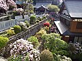
- Stroll uchinuku – This walk starts at the Saijō Tourism Office which is on the right as you exit Iyo-Saijō Station, next to the Shikoku Railway Culture Museum. Saijō is as famous for its mountain spring water as it is for its festivals. These waters flow naturally in the city and have been arranged into springs called "uchinuku ". The tourist office can give you a map (available in English) and a short description of the route to reach many of these sources throughout the city. The website has maps, stages and other information in Japanese. Bring your own bottle and drink its water which many locals pump right into their homes! The route passes near the site of the ancient Saijō Castle, now a school, which still has a moat and a castle gate. It also passes by pleasant fountains and tree-lined avenues.
To buy
- Uchinuki no Kura (in the newly renovated main shopping arcade of Saijō; To 10 min walk from Iyo-Saijō station) – This souvenir shop specializes in locally made handicrafts and clothes. Managed by a non-profit association, each of its departments is dedicated to the products of a craftsman. Popular products include t-shirts made from recycled kimonos, sculpted cedarwood, and indigo-dyed fabrics.
- Farmers markets – There are several in the Saijō area. The biggest is that of Shu-chan in the Tōyo district, but the most accessible for visitors is that of Suito located near Saijō High School in the city center. Most products and foods are local: Saijō is famous for its eggplants, persimmons, grapes and spinach. Next door is a bakery that uses mochi (sticky rice paste) in the dough, which gives his pastries and bread a truly unique consistency and flavor.
Eat
Have a drink / Go out
- Asahi Brewery (on the Saijō waterfront; shuttle bus from Iyo-Saijō station to the brewery) – The Asahi Beer production site on Shikoku Island.
- On the road in front of the station are several Japanese-style bistros.
- TO 10 min walking distance from the station is a street where most of Saijō's bars are located. At the station turn left onto Ekinishi-dōri Street, cross the street and turn right directly after Iyokko ramen. About 3 blocks past this street is a series of pubs and bars.
Housing
There are several hotels in the blocks surrounding the station. They are all business hotels welcoming mostly business people. Count 7 500 JPY To 9 000 JPY for a room.
Communicate
Manage the daily
Around
- 1 Mount Ishizuchi (石 鎚 山, ishizuchi-san) (To 1 h of bus) – The highest mountain in Shikoku.