 | |
| Short dates | |
| Capital | Compatsch |
|---|---|
| currency | Euro (EUR, €) |
| surface | 57 km² |
| languages | Ladin, German, Italian |
| Time zone | CET |
The Seiser Alm (Italian Alpe di Siusi, Ladin Mont Sëuc) is the largest high alpine pasture with a size of 57 km² Europe in the South TyroleanDolomites in Italy . At an altitude of 1680 m s.l.m. up to 2350 m s.l.m. lying down it is one of the largest closed high plateaus in the Alps. The area, which is intensively developed for tourism, invites you to go on long hikes and bike tours in summer and to go skiing and snowboarding in winter.
places


- 1 Compatsch, less common Compatsch is the main town of the Alpe di Siusi. From Seis am Schlern During the day, since the access road to the Alpe di Siusi is closed to private traffic from 9:00 a.m. to 5:00 p.m., it can be reached with the 4,300 meter long Seiser Alm cable car, which overcomes a difference in altitude of 800 meters and for Distance takes 15 minutes. Alternatively, you can also use the Bus line 10 "Seiser Alm Express" (Seis am Schlern <> Castelrotto <> Compatsch) or if the Seiser Alm cable car is closed in the off-season with the Bus route 179 (Seis am Schlern <> Castelrotto <> Compatsch <> Saltria). More information at www.seiseralm.it and www.sii.bz.it.
- 2 Saltria is at the end of the street over the Alpe di Siusi. In the small town, which also houses hotels and boarding houses, you can also find the valley stations of two cable cars and the bus turning loop for the regular buses. If you want to go to Saltria, you have to go to Compatsch Bus route 11 "Almbus" (Compatsch <> Ritsch <> Saltria) get in, or in the off-season you can take the up to Saltria without having to change trains from the valley Bus route 179 (Seis am Schlern <> Castelrotto <> Compatsch <> Saltria).

mountains


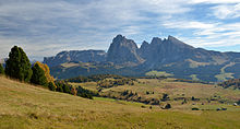
- 3 Sassolungo (3181 m) - The main summit of the Sassolungo Group is a well-known climbing mountain, which was first climbed on August 13, 1869 by Paul Grohmann (1838–1908). The relatively long normal route leads through the southwest face up to the summit connection ridge (II) and over this to the summit (III). Hikers can take the cable car to the Langkofelscharte (2681 m); the Sassolungo Hut (Ladin Utia de Dantersasc, Italian Rifugio Vicenza) is located at an altitude of 2253 meters at the confluence of the Plattkofelkar and the Langkofelkar and serves as a base for hikes and climbing in the Langkofel group. On the summit of the Sassolungo itself there is a bivouac box (Bivacco R. Giuliani al Sassolungo) as an emergency shelter.

- 4 Plattkofel (Sas plat, Sasso Piatto), (2969 m) - The Plattkofel owes its name to its striking shape of a right-angled triangle, which is best seen from the Alpe di Siusi. The starting point for a hike to the Plattkofel can be next to the Sassolungo Hut (2253 m) also the Plattkofelhütte (Ladin Utia de Sas Plat, Italian Rifugio Sasso Piatto), which is located at an altitude of 2297 meters on the Fassajoch. The two mountain huts are connected by the Oskar-Schuster-Steig (via ferrata, I – II, partly secured with ropes), which leads directly over the summit.

- 5 Rosszähne (2653 m) - The row of peaks cut by small notches, the largest elevation of which is the Großer Rosszahn (2653 m), which towers roughly in the middle of the chain, is part of the Schlern group and is accessed via the Maximilian via ferrata (difficult, long tour with short secured sections). Based on the Tierser-Alpl-Hut (2444 m) the entire Rosszahnkamm up to the Roterdspitze, which with 2655 meters is the highest peak of the Schlern group. From the Roterdspitze you can hike on via the Dolomitenhöhenweg (Via Alpina) to the Schlern.

- 6 Schlern (2563 m) - Despite its low height, the Schlern is a landmark due to its characteristic shape South Tyrol. The summit can be climbed from Schlernhaus (Italian Rifugio Bolzano or Rifugio Bolzano al Monte Pez), which is at an altitude of 2457 meters. Since you can reach the highest point of the Schlern plateau, the Petz (Monte Pez in Italian, 2536 m), in just 20 minutes from the Schlernhaus, the mountain hut, unlike other alpine mountain huts, is not so much a base for climbing peaks, but more an independent tour destination significant. The easiest hiking trail via the Saltnerhütte or Saltner Schwaige up to the Schlernhaus is known as the tourist trail.

- 7 Bullaccia (2176 m) - Known as a good vantage point, Puflatsch is a popular hiking destination in summer. The easiest way to get up is from Compatsch and leads via the Puflatschhütte (also Dibaita, Italian Rifugio Bullaccia, 1950 m) to the Puflatschalpe. This is where the Puflatschumrundung (PU) begins; either you continue to follow the road to the Arnikahütte in order to then reach the summit via the Goller Kreuz, or you hike on a more direct route via the Filiner Kreuz. Another option is the Schnürlsteig from the hamlet of Bulla. The so-called witch's benches can also be found in the summit area.

background


„“From the village of Castelreudt there is also the allerschonische and great alm, if you do not find the same in landt, and you are a teische meil [German mile] away from the village, called the Seysser Almb, whereupon you get jarlichen in sumber into the 1,500 kie [cows] and 600 ogsen [oxen] have been preserved and not valued [not less than] in the 1,800 futer hey [loads of hay] and also some of today's zendten [hundred quintals] judge lard and cheese made. So with 400 heythillen [Heustädel] there should be stone and 100 kaserthillen [Schwaigen] and umb Jacobi [25. July] at 4 or 5 weeks at 4,000 man and woman above leagues and arbeyten tain in hey and the kroffigist [strongest] and peste hey, as far as one finds in lands, is. "“
getting there


By car

The road from Seis am Schlern Compatsch is closed to private traffic from 9:00 a.m. to 5:00 p.m. the parking fee for the car park in Compatsch is 15 euros per day. Guests who have booked accommodation on the Alpe di Siusi receive a special permit, which can be obtained free of charge at the start of the roadblock if the hotel provides proof of reservation. The departure from Compatsch is possible at any time.
In winter it is compulsory to bring winter equipment (winter tires, snow chains) with you, the latter must be put on the roads when there is snow, which can be expected until April. The access road to the Alpe di Siusi is not as well maintained as the main roads, which means that uncleared and icy sections are to be expected.
With public transport
Seiser Alm Express
The Bus line 10 "Seiser Alm Express" runs daily in the main season up to the Alpe di Siusi. The route is Seis bus station <> Kastelruth bus station <> Info point <> Spitzbühl-Frommer <> Compatsch. A single trip costs 10 euros, a return trip costs 15 euros (as of winter 2014/2015). Dogs are required to wear a muzzle on the buses. The timetables and further information can be found at www.seiseralm.it.
Alpe di Siusi cable car
The Seis-Seiser Alm cable car, short Alpe di Siusi cable car, connects Seis am Schlern with Compatsch. It runs daily from 8:00 a.m. to 6:00 p.m. during the main season, a single trip costs 10 euros, and an ascent and descent cost 15 euros (as of winter 2014/2015). Dogs are required to wear a muzzle in the train cabins. More information at www.seiseralm.it.
Orbit Alpe di Siusi
The Orbit Ortisei - Alpe di Siusi (Ovovia Alpe di Siusi) connects Ortisei in Val Gardena with the northern Alpe di Siusi. It runs daily in the high season from 9:00 a.m. to 6:00 p.m., a single trip costs € 11.20, and a return trip costs € 16.20, or with Sun chairlift € 18.90. The latter is in operation every day in the main season from 9 a.m. to 5 p.m. and is directly connected to the gondola lift. Children up to and including eight years travel free when accompanied by their full paying parents; Dogs are required to wear a muzzle in the train cabins (as of winter 2014/2015). More information at www.seiseralm-seilbahn.com.
mobility


Line buses (public transport)
The following bus lines operate in the high and low season over the Alpe di Siusi and are in the Combi Card and Seiser Alm Card Gold included (prices as of winter 2014/2015):
- Line 10 "Seiser Alm Express": Seis am Schlern <> Castelrotto <> Spitzbühl <> Compatsch
- Prices: One way 11 euros; Round trip 17 euros
- Line 11 "Almbus": Compatsch <> Ritsch <> Saltria
- Prices: One way 2 euros
- Line 12: Saltria <> Monte Pana (St. Christina in Val Gardena)
- Prices: One way 3 euros; Return trip 5 euros
- Line 179: Seis am Schlern <> Castelrotto <> Compatsch <> Saltria
- Only runs when the Seis-Seiser Alm orbit is closed!
Timetables and further information can be found on www.seiseralm.it and www.sii.bz.it
Mountain railways
A large number of lifts and cable cars are distributed across the Alpe di Siusi. Below is a small selection:
Seggiovia Panorama chairlift
The Panorama 6-seater chairlift connects Compatsch (1815 m) with the mountain inn of the same name Panorama (2015 m) north of the Ladinser Moos. Possible hiking destinations starting from the mountain station are the Laurinhütte (2021 m), the Sattler Schwaige (2080 m) or the Peterlunger Schwaige (2033 m) on the Peterlunger Lacke. The chairlift operates daily from 9:00 a.m. to 5:00 p.m. in the winter season and daily from 8:30 a.m. to 6:00 p.m. in the summer season (summer low season only until 5:00 p.m.). More information at www.panoramaseiseralm.info.
Telecabina Florian
The Florian lift As a four-seater chairlift connects Saltria with the Williams Hut (2100 m). Zallinger Hütte (2037 m), Murmeltierhütte (2132 m) and Plattkofelhütte (2300 m) can be reached on foot in a short time. The chairlift is open daily from 9:00 a.m. to 5:00 p.m. during the main season; the prices in the winter season are 7 euros one way and 10 euros there and back, and in the summer season 9.50 euros one way and 15 euros there and back. Bicycles are transported for an extra charge of 2 euros (as of winter 2014/2015). More information at www.florianlift.it.
In the winter
In winter, the lifts operate from 9:00 a.m. to 5:00 p.m., with the exception of the Spitzbühlbahn, which opens at 8:30 a.m., and the gondola lifts, which operate from 8:00 a.m. to 6:00 p.m. Most of the lifts are modern and have a high capacity (4-seater and 6-seater chairlifts).
Ski passes can be obtained from the ski pass office in Compatsch (during the week until 2 p.m., on weekends until 4 p.m.). They apply to the Alpe di Siusi and the ski region Val Gardena. Disabled people receive a discount of 20% on proof of this. A ski pass for all 12 ski regions of the Dolomites be resolved, the offer is called Dolomiti Superski.
Tourist Attractions


Witch banks
The Witch banks are to be found in the summit area of the Puflatsches (2176 m) and represent rock steps made of Augitporphyry shaped like armchairs; a rarely seen rock formation, from which one has a beautiful view over Castelrotto and the Val Gardena Has. According to the legend, which can also be read on a wooden board near the Berggasthof Puflatsch, the head witch likes to sit on the witch's benches while enjoying the beautiful view. At night the Sciliar witches gather at the witch's benches before they fly over the Alpe di Siusi to the Sciliar with exuberant shouts and as a closed horde, where they usually celebrate wild festivals on Thursdays.
Franzikuskirche
The Church of St. Francis (Ladin Dlieja de San Francesch, Italian Chiesa di san Francesco) was built in Compatsch in 2008 and consecrated to St. Francis (Francis of Assisi) on September 20, 2009. As early as the 1960s there were plans to build a church on the Alpe di Siusi. The architect Walter Dietl opted for the dove as the basis for the design of the Franziskuskirche, as this is, in addition to the symbol for the Holy Spirit, the biblical original motif for peace and security, understanding and encounter, as well as peace and security. The ground plan of the church also shows the contours of a pigeon's body.
Parish Church of St. Leonhard
The 8 Parish Church of St. Leonhard is a small listed church in Bulla, a small hamlet north of the Alpe di Siusi, which administratively Castelrotto belongs. The first chapel, the cattle patron St. Leonhard in Bulla, was built in the Romanesque style in the 13th century at the latest. Towards the end of the 15th century it was Gothicized and enlarged; a church in Bulla was first mentioned in 1339. The Romanesque tower of this is still preserved today, while it was enlarged in 1555 and lengthened and baroque in 1740. In 1855 the nave was extended, and in 1895 the spire was built. It is also worth seeing in Bulla Uhrerhof rose gardenwhich overlooks 5000 roses Dolomites houses.

activities
In summer
hike
Hiking trails with a total length of 350 kilometers run across the Alpe di Siusi. Good starting points are Compatsch and Saltria, between which the Almbus shuttles back and forth. If you don't just want to hike through the open alpine landscape of the Alpe di Siusi, you will find between Saltria and Monte Pana (above St. Christina in Val Gardena) also hiking trails through forests.
Hans & Paula Steger way
The Hans & Paula Steger way Between Compatsch and Saltria there is a 4.65 km long nature and culture trail that is also suitable for prams. Information boards along the way provide information about the region and tell of the legend of the Partschott. The path is marked with the no. 30; The Hans & Paula Steger Weg can be shortened or lengthened as required by several bus stops along the way and other crossing hiking trails. If there is enough snow, the Hans & Paula Steger Weg is prepared as a winter hiking trail in winter; Crossing ski slopes can be safely passed over bridges.
Puflatschumrundung
That too Bullaccia circular route or Puflatschrunde called hiking route is about ten kilometers long and is marked as No. 14, No. 24 and PU. It runs from Compatsch over the Puflatschhütte and the Arnikahütte to the Goller Kreuz. From there you hike with a beautiful view past the legendary witch's benches and the summit of the Bullacca to the Filin Cross. Now back south over the Puflatschalpe to Compatsch.
Friedrich-August-Weg
The Friedrich-August-Weg, marked as No. 7A, 9 and 557, connects Saltria with the Sella Joch for about 10.5 kilometers. On the way you pass the Zallinger Hütte (2037 m), the Plattkofelhütte (2300 m), the Rif. Sandro Pertini (2300 m), the Rif. Friedrich August (2298 m) and the Rif. Salei (2222 m). The ascent from Saltria can be shortened with the Florian lift. At the Sella Joch there is a bus stop from which you can go down to Val Gardena can drive.
Witches springs barefoot and adventure trail
The Witches springs barefoot and adventure trail As a circular route over a length of two kilometers, it stimulates the various senses of people. The consistently flat hiking trail begins at the Tirler Alm / Hotel Tirler and is marked by works of art about the witch Curandina and the wise owl Emma. Intermediate destinations and stations of the sensory adventure trail include the natural monument sulfur springs in the "Hexenwald" and the Hexenblick Puflatsch.
Climb
Oskar-Schuster-Steig
The Oskar-Schuster-Steig leads from the Sassolungo Hut (2253 m) up to the Plattkofel (2860 m). As a medium-difficult mountain tour (II. Level of difficulty (UIAA)) it has only a few secured sections, but it is not recommended for beginners! Because of the high risk of falling rocks, it is essential to wear a protective helmet in addition to the usual climbing equipment. The descent from the Plattkofel is via the much used and easy to walk hiking trail no. 527 zur Plattkofelhütte, from which you can return to the Sella Joch via the Friedrich-August-Weg.
Maximilian via ferrata
The Maximilian via ferrata runs from the Tierser-Alpl-Hut (2444 m) from over the entire Rosszahnkamm. The via ferrata is in difficulty II (UIAA) thanks to short secured sections. In the Roterdscharte (2435 m) there is an emergency descent to the south. The descent begins west of the Roterdspitze (2655 m) and leads back to Tierser-Alpl-Hut. This can be reached from Compatsch either via the Rosszahn Scharte (2499 m) or the Dialer-Seiser Alm hut (2145).
Mountain bike
Numerous gravel paths on the Alpe di Siusi are ideal for mountain biking. Possible destinations on a mountain bike tour are, for example Tierser-Alpl-Hut (2444 m) or the Zallinger Hütte (2037 m). Those who want to cycle up to the Alpe di Siusi can do so from Kampidel im Fasstal (via Mahlknecht), St. Christina in Val Gardena (via Monte Pana), Runggaditsch (via Bulla) and Seis am Schlern (via Frommer) do. All cable cars also transport bicycles.
To run
The high plateau of the Alpe di Siusi has relatively little gradients, which is why it is also well suited for extended running tours. Numerous tour suggestions open up the area. More information at www.seiseralm.it.
Alpe di Siusi half marathon
The Alpe di Siusi half marathon celebrated its premiere in 2013 and the 3rd edition will start in 2015. The 21-kilometer route has an altitude of 601 meters; the number of participants is limited to 500 runners. Part of the half marathon is the Alpe di Siusi Running EXPO. In the first months of summer, the Alpe di Siusi is a traditional training area for Kenyan marathon runners, who prepare for the autumn marathons under the special altitude conditions of the Alpe di Siusi.
To fly
A popular starting point for paragliders, hang-gliders and model pilots is the Spitzbühlhütte (1980 m) at the mountain station of the Spitzbühl lift. Tandem flights also start from the mountain hut, offered by Tandem Paragliding. More information at www.seiser-alm-it and www.suedtirol.info.
In the winter
Alpe di Siusi ski area
The Alpe di Siusi ski area is located at an altitude of 1,060 to 2,245 meters and is linked to the Val Gardena ski area and Dolomiti Superski, the world's largest ski carousel with over 1,220 kilometers of slopes. On the Alpe di Siusi there are 60 kilometers of slopes (30 km easy, 29 km medium difficult, 1 km difficult), connected by 23 lifts (2 cable cars, 17 chair lifts, 4 drag lifts). Night tobogganing always takes place on Tuesdays and Thursdays at the Marinzenlift from 7:00 p.m. to 10:00 p.m.
Alpe di Siusi Snow Park
The Alpe di Siusi Snow Park received a Snowsummit Award from ISPO and is the largest snow park South Tyrol and the second largest snow park Italy. With a length of 1.5 kilometers, it can be found a little away from the slope area near the Laurin slope and is divided into two areas. In addition to the approximately 70 obstacles, the main attraction is a 120 meter long halfpipe.
Cross-country skiing
The Cross-country trails on the Alpe di Siusi are part of the cross-country ski carousel Dolomiti Nordicski, the largest cross-country ski area Europe with over 1,300 km of trails. On the Alpe di Siusi alone, eleven cross-country trails with a total length of around 80 km are prepared in different degrees of difficulty.
Sledding
Almost 20 kilometers of slopes are prepared for tobogganers on the Alpe di Siusi in winter. The individual toboggan runs are Icaro-Monte Piz (1.4 km), Panorama (1.4 km), Spitzbühl (2 km), Bullaccia (2 km), Molignon (3.5 km), Zallinger (5 km), Tuffalm (2.1 km) and the Natural toboggan run on the Völser Weiher (2.1 km).
The Blue Ribbon of the Alpe di Siusi
The Blue Ribbon of the Alpe di Siusi is an annual ski race in popular sport. After the traditional race was held for the first time from 1947 to 1958, it has been held again by the football club Team 92 Schlern since the 2000/2001 winter season. The ski race is rated in an alpine combination between downhill skiing and slalom. More information at www.dasblaueband.it.
kitchen
- 1 Refuge Mahlknechthütte, Joch 28, 39040 Alpe di Siusi. Tel.: 39 0471 727912, Fax: 39 0471 727863, Email: [email protected]. The Mahlknechthütte is located at an altitude of 2054 m and is open from mid-May to early November and from Christmas to Easter.
- 2 Gostner Schwaige. Tel.: 39 347 8368154. The Gostner Schwaige is regularly awarded 14 points by the “Gault Millau” gourmet guide; all dishes are freshly prepared. The alpine hut is located at an altitude of 1900 meters and is open from June to October and from December to the beginning of April.
- 1 Rauchhütte, Saltria 29, 39040 Alpe di Siusi. Tel.: 39 0471 727830, Email: [email protected]. The Rauchhütte in the heart of the Alpe di Siusi is located near the road between Compatsch and Saltria at an altitude of 1750 m, which is why it is easy to get to by bus (own bus stop).
- 2 Sanonhütte, Piz 19, 39040 Alpe di Siusi. Tel.: 39 0471 727002, Email: [email protected]. The Sanon Hut is probably the most rustic hut on the Alpe di Siusi (1800 m) and is open from the beginning of December to Easter, and in the summer season from the end of May to the end of October.
accommodation
- 3 Adler Mountain Lodge, Pizstrasse 11, 39040 Alpe di Siusi. Tel.: 39 0471 723000, Fax: 39 0471 723077, Email: [email protected]. The Adler Mountain Lodge, which opened in 2014, is located in a secluded location directly in the Alpe di Siusi ski area. In addition to the Alpine suites, you can also spend your holidays individually in chalets.
- 4 Alpina Dolomites *****, Compatsch, 39040 Alpe di Siusi. Tel.: 39 0471 796004, Email: [email protected].
- 5 Hotel Saltria ****, Saltria Str. 36, 39040 Alpe di Siusi. Tel.: 39 0471 727966, Email: [email protected].
- 6 Berghaus Zallinger, Saltria 74, 39040 Alpe di Siusi. Tel.: 39 0471 727 947, Fax: 39 0471 729 200, Email: [email protected]. Room A: Shower / WC, telephone, safe, TV connection, sun terrace, some with balcony, Room B: Simple hut rooms with bunk beds and shared shower / WC on the floor, accessible by car at the foot of the Plattkofel via unpaved roads.
- 7 Tirler - Dolomites Living Hotel **** S, Saltria Str. 59, 39040 Alpe di Siusi. Tel.: 39 0471 727927, Email: [email protected]. First hotel in Italy with ECARF certification, organic hotel with the Best Sleep guarantee seal, luxury family hotel, located directly on numerous slopes and hiking trails of the Alpe di Siusi.
security
Mountain rescue service Seis, Tel. 39 0471 705222 (around the clock) or 118. For more information, go to www.bergrettung.it/seis.
Practical advice
The shopping possibilities are limited. Apart from a very small grocery store on the main street, there is no shop for daily needs. In winter, many restaurants in Compatsch close at around 6 p.m., which is why you have to rely on the hotel's own offers for evening meals. On the other hand, there are many tourist-oriented shops (in winter: snow sports articles as well as ski or toboggan rental).
A public toilet is located at the mountain station of the Seiser Alm Bahn.
climate
The Dolomites are protected to the north by the main Alpine ridge from low pressure areas and cold north winds, the climate is a mixture of alpine high mountain weather with influences from the maritime climate of the southern Alpine region, in general the Dolomites have a continental-alpine climate:
- The summer are considered sunny, warm and dry. Rain is rather rare, the daytime temperatures reach up to 25 ° C and in the high valleys up to 20 ° C. Because of the constant light wind in the mountains, the air is rarely "stuffy"; it cools down at night.
- The autumn occurs significantly later than in the regions north of the Alps, high pressure situations are usually quite stable and then also fog-free and sunny.
- The winter are considered dry and cold, between December and March the statistics show about 100 days of sunshine, temperatures of down to -20 ° C can be reached.
- The spring then begins, depending on the altitude, in April or May, in the valleys a little earlier, but the season for skiers is usually a little shorter than in the central and northern parts of the rest of the Alps.
There is no particularly pronounced season for precipitation.
The climate for the Dolomites is roughly the same without any particularly pronounced differences, the differences result locally from the altitude and from the orientation towards the sun, in the southwest the influence of the Adriatic is noticeable with a little more clouds.
The current mountain weather for South Tyrol www.provinz.bz.it.
Web links
- Official website of the Alpe di Siusi tourism association - Schlerngebiet - Kastelruth
- Seiser-Alm.it in German
- Winter vacation on the Alpe di Siusi. In:Hessian / Lower Saxony General, Tuesday February 3, 2015, accessed on March 7, 2015. Around 60 kilometers of slopes, snow-sure location and an excellent mountain panorama: skiers immediately feel at home on the Alpe di Siusi in South Tyrol. This is also due to the culinary delicacies.
