Paths of the Madonie - Sentieri delle Madonie

Paths of the Madonie
Pizzo Carbonara
State
Region

Introduction

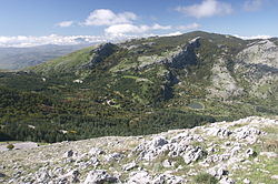
The Madonie are a mountain system of Sicily. They present a varied territory with multiple paths with which to discover the territory.

Flora and fauna

The establishment of the Madonie Park, the exceptional habitat and the relative population density allow the Madonie to boast almost 90% of the fauna and floral species among those present in Sicily. The park consists of four different areas with different protection (from integral to controlled) and does not cover the whole area of ​​the Madonie, in particular avoiding the coast.

Wildlife

The woods, valleys and plateaus of the Madonie are inhabited by different species that live in freedom. Wild boars due to the absence of an antagonist are widespread. In the Madonie park there are: wild boar, fallow deer, hare (italica), hedgehog (european), red fox, weasel, wild cat and marten. Among the small mammals: the porcupine, the dormouse, the oak, the hedgehog, the wild mouse, the hare and the wild rabbit.

Of the large birds of prey remain the Egyptian vulture, the golden eagle and Bonelli's eagle, the peregrine falcon, the tawny owl, the owl and the scops owl. Among the other ornithological presences we remember the rock partridge, the coral chough, the dipper, the blackcap, the black-eyed, but also blackbirds, solitary sparrows, finches, nightingales, goldfinches, great tit, hoopoe, long-tailed tit and climbing creepers. There are also many reptiles: green lizard, gongilo, rat snake, smooth snake.

Lepidoptera

Certainly worthy of attention is the entomological universe in which there are at least 30 endemic species, where some butterflies (Podalirio, Polissena, Apollo of Sicily, Briseide) stand out for their splendor and scientific interest. Nearly 90 species of diurnal butterflies divided into families:

  • Hesperiidae (14 species)
  • Papilionidae (5 species)
  • Pieridae (11 species)
  • Lycaenidae (19 species)
  • Nymphalidae (41 species)

Among the endemic species are present: Hesperia comma hemipallida, Parnassius apollo siciliae, Lycaena alciphron bellieri, Eumedonia eumedon nebrodensis, Polyommartus daphnis pallidecolor.

Flora

The Madonie are characterized by Mediterranean scrub landscapes whose most typical presences are the myrtle, the strawberry tree, the heather, the woody euphorbia, you pass gradually rising in altitude in the presence of the almond and chestnut trees, holm oaks and downy oaks . Going up again, the patches of holly, oaks and beech trees extend. The latter in autumn gives us extraordinary landscapes painted in orange and gold.

The undergrowth offers a flora richly represented by orchids, violets, cyclamen, peonies, and in the watery environments called “margi” the rare royal fern, and numerous endemisms. At the median altitudes we find the Cupani gorse (Genista cupanii), the hemispheric juniper (Juniperus communis subsp. Hemisphaerica) and the Madonie astragalus (Astragalus nebrodensis). In the high altitudes, botanical rarities such as the "Basilisk" (Chachys ferulacea) grow from which the famous and precious mushrooms of the same name grow, the giant hollies that reach up to 15 meters in height. L'Abies nebrodensis (native tree of the Madonie) at the beginning of the 20th century it was considered to have disappeared until in 1957 it was rediscovered in the Vallone Madonna degli Angeli, probably surviving thanks to isolation.

Among the endemics of the plant world we have: Starry viper, Gasparrini's broom, Three-leaved Colchylus, Nebrodi's Astragalus, Sorrentino's Astro, Violet of Nebrodi, Candid Senecione, Mouse Tail, Mountain Linen, Half Moon Ophrid, Snow Thistle , Garlic of the Nebrodi, Sicilian Androsace, Violaccila di Bonanno, Broom of Cupani, Sicilian Fairy Flax, Sicilian Stregonia, Alisso dei Nebrodi, Ferulaceous Prango.

Trails

All details relating to the trails described here can be found in This Page.

Nature trail 2 of the Abies nebrodensis - Quacella
N2
Length: 6.9 kmTotal difference in height of the stage: there may be greater or lesser differences in height and / or descent 400 mTime 3 hoursDifficulty Hiking
Abies nebrodensis (31505534280) .jpg
The path is dedicated to the observation of the Abies nebrodensis and leads to the Vallone Madonna degli Angeli. The starting point is on the SP119. After about 1.5 km, on a bend in the track, a path forks turning right. From here we meet the first specimens of Abies, easily recognizable by the bearing of the bell-shaped crown, and by the arrangement of the branches arranged in a cross.
Path Italy (from Scillato to Geraci Siculo)
566a 561 G4 554 579 575a
Length: 44 kmTotal difference in height of the stage: there may be greater or lesser differences in height and / or descent mTime 25 hoursDifficulty Expert hikers

Battle Plan in the fall
DepartureFrom: Scillato (493 m a.s.l.)Travel time5 hours
DestinationTO: Piano Battaglia (1600 m a.s.l.)The difference in height means the total difference in height of the stage, there may be higher differences in both downhill and uphill within the stage1100 m

Description: It must be said that this stretch cannot be covered during the months from May to October, to safeguard the nesting of the Golden Eagle. The itinerary can be done starting from the Luigi Orestano Refuge, or from 1 Portella Colla. There is also a signposted detour path that connects with Portella Colla.

This 15 km stretch is quite challenging: the path climbs up a series of hairpin bends until it reaches an altitude of 1436 meters at Casa di Mastro Peppino, where it will be possible to stock up on water. Casa di Mastro Peppino is located in the Vallone Nipitalva and then reaches Piano Cervi: a large depression in the center of which a small lake created by the thawing of the snow has been created.

The path goes up again allowing the view of Monte dei Cervi, then re-enters the beech wood and descends into the Forest State Area. The stretch arrives at Portella Colla at an altitude of 1,420 m. from where you can see the Antenna Grande mountain range. From here continue to Piano Battaglia where there are various shelters and hotels to stay overnight.


DepartureFrom: Piano Battaglia (1600 m a.s.l.)Travel time4 hours
DestinationTO: Madonna dell'Alto (1750 m a.s.l.)The difference in height means the total difference in height of the stage, there may be higher differences in both downhill and uphill within the stage600 m

Description: From Piano Battaglia you reach Case Faguara in correspondence with the homonymous valley. You go along the river to go down towards Case la Pazza. At this point you cross the SP54 and continue along path 554. From here you go up from the Pomieri district and reach the Vallone Madonna degli Angeli passing near the "Sentierodegli Abies nebrodensis". The path continues to climb up to the Sanctuary of Madonna dell'Alto at 1819 meters above sea level. from where you can make a detour to enjoy a beautiful view.


Petralia Sottana
DepartureFrom: Madonna dell’Alto (1750 m a.s.l.)Travel time2 hours
DestinationTO: Petralia Sottana (900 m a.s.l.)The difference in height means the total difference in height of the stage, there may be higher differences in both downhill and uphill within the stage-900 m

Description: From this point the path begins to descend steeply and with several hairpin bends along the Vallone della Cella reaching a Regia Trazzera 284 which crosses the Contrada Gisa, arriving at the Southern Imera River. From here you reach the center of Petralia Sottana.


Geraci Siculo
DepartureFrom: Petralia Sottana (900 m a.s.l.)Travel time3 hours
DestinationTO: Geraci Siculo (1100 m a.s.l.)The difference in height means the total difference in height of the stage, there may be higher differences in both downhill and uphill within the stage500 m

Description: After passing the gate of Portella Ferrone at an altitude of 1160 meters, you reach the Gorgo di Pollicino, an important lake for migratory birds. Continue climbing on an open track passing near springs and drinking troughs to the highest point where the descent begins. From here you follow a forest road to then reach the Antico Fontanile di Geraci Siculo and finish the route.

From the Battaglietta path to Piano Sempria
552
Length: 7 kmTotal difference in height of the stage: there may be greater or lesser differences in height and / or descent 600 mTime 5 hoursDifficulty Hiking
From Piano Battaglia, in the locality of Battaglietta at an altitude of 1630 m. starts the path that takes a dirt track slightly uphill where you can see the sinkhole of the Battaglietta. Then the path begins to climb with a series of hairpin bends, enters a beech forest and comes to a crossroads. Turn right for Monte Ferro and for the Vallone di Zottafonda, proceed along a short stretch in the open and re-enter the beech forest where a centuries-old maple is visible on the right. The path continues uphill until it reaches a clearing dominated by oak trees of considerable size, but also by maples and beeches. Here the route ends once you reach the Crispi Refuge.
Pizzo Carbonara path
551
Length: 5.6 kmTotal difference in height of the stage: there may be greater or lesser differences in height and / or descent 350 mTime 4 hoursDifficulty Expert hiker
Pizzo Carbonara
Pizzo Carbonara is the second highest mountain in Sicily after Etna with its 1979 meters above sea level. The route is quite challenging and should only be tackled in conditions of excellent visibility. The path begins in the first part following the same path as the path from Battaglietta to Piano Sempria, then turns to climb to the top of Pizzo Carbonara where you can enjoy an exceptional view of almost the whole island. Going around Pizzo Antenna from east to west, you reach Piano della Principessa and then Pizzo Carbonara, the highest point. Then the path turns left leaving Pizzo Palermo behind and then back again to Piano Battaglia.
From the Stagno Gorgonero path to Piano Catarineci
558
Length: 3 kmTotal difference in height of the stage: there may be greater or lesser differences in height and / or descent 400 mTime 3 hoursDifficulty Hiking
From SP54 next to the Adventure Park and the Gorgonero pond you enter the path that climbs up in the middle of a dense forest of chestnut, pine and holly trees. You pass a refuge and a drinking trough, continue along the path that crosses Vallone Scopalacqua until you reach Piano Catarineci, where it is often possible to see horses in the wild.
Path Portella Mandarini
563
Length: 13 kmTotal difference in height of the stage: there may be greater or lesser differences in height and / or descent 500 mTime 5 hoursDifficulty Hiking
From SP54 you enter a dirt path that runs for about 700 m until you reach the junction for Marcato D'Alfano. Cross a holly grove and, skirting Pizzo Argentiera, you reach a vast clearing where the church of San Cosimano stands. It continues with a series of ups and downs where you can admire the views over Geraci Siculo is Castelbuono. Near Cozzo Giardinello you enter a small road that climbs up to reach the SS. Trinità at the entrance of Geraci Siculo.
Nociazzi path - Madonna dell'Alto - Monte San Salvatore
553
Length: 5 kmTotal difference in height of the stage: there may be greater or lesser differences in height and / or descent 700 mTime 3 hoursDifficulty Hiking
This challenging excursion starts from the hamlet of Nociazzi near Castellana Sicula. Beyond the hamlet there is a path to the Sanctuary which climbs along the slopes of the Pomo. As you go up the panorama offers views over the valley of the Southern Imera river. Continue steeply up between the Rocche del Pomo on the left and Rocca Vaccaro on the right. After the southern slopes of Monte Alto, where the Sanctuary stands, is Monte San Salvatore. Turning right, the path leads to the Sanctuary of Madonna dell'Alto at 1819 meters above sea level.
Path Case la Pazza - Piano Pomo - Piano Sempria
565
Length: 6 kmTotal difference in height of the stage: there may be greater or lesser differences in height and / or descent 250 mTime 4 hoursDifficulty Hiking
Immediately before the ford of the Faguara valley, you can see the outcrop of gray Dolomite breccias, mixed with clay and marls ranging from gray to yellow, passing through blue. Passing on the left side of the Faguara valley, after a short climb, we reach the "Balzo Canna" pass. From here it is possible to conquer the peak of "Pizzo Canna". This area is one of the Golden Eagle nesting sites. Then you reach Piano Pomo where you recover your strength and continue to Piano Sempria, up to the Crispi refuge.
Collesano - Isnello path
560
Length: 7 kmTotal difference in height of the stage: there may be greater or lesser differences in height and / or descent 600 mTime 7 hoursDifficulty Hiking
Taken from Collesano there SP 9ii towards Scillato, on the left there is a track that climbs towards the southeast. The track sometimes becomes a steep path that is not always clearly visible. Shortly after you reach the Case Volpignano. You then reach the Munciarrati junction, and then arrive in one of the largest and most intact wooded areas of the Madonie. After the crossroads on the SP54, you reach the slopes of Pizzo Dipilo which with its 1385 meters, represents a difficult and demanding ascent to then reach the final destination.
Path of Peace
587
Length: 9 kmTotal difference in height of the stage: there may be greater or lesser differences in height and / or descent 670 mTime 5 hoursDifficulty Hiking for experts
This path was traveled in 2004 on the occasion of the "Summit for Peace" during the National Trail and SNE Meeting in 2005. It begins as a dirt track and proceeds in the initial part along the Reggia Trazzera that connected Petralia with Castelbuono. After just over a kilometer (making a detour) you reach the medieval bridge of San Brancato, then turn left into a mule track that reaches the slopes of Pizzo Sant'Otiero up to Gorgo Nero, then after a couple of kilometers, you reach Portella di Mele at an altitude of 1,500 m. Continue along an ancient and beautiful path that enters the beech forest and continue reaching Pizzo Inferno at an altitude of 1,700 m. The path continues even steeper passing from the summit of Monte San Salvatore from whose top you can enjoy beautiful views. At this point you go down slightly and then take the climb to the Madonna dell'Alto Sanctuary at an altitude of 1,827 m.
Gratteri - Isnello path
601
Length: 8.5 kmTotal difference in height of the stage: there may be greater or lesser differences in height and / or descent 450 mTime 5 hoursDifficulty Hiking
This trail connects Scratchers to Isnello. The route begins by crossing the Grotta Grattara park, climbing inside the pine forest to reach the cave. After the cave you come to an uncovered stretch of road, where the base of Pizzo Dipilo is on the right. After passing Pizzo Dipilo, you finally reach the limit of the "Querceto di Isnello" which represents one of the largest and best preserved wooded areas in this area.
Vallone dei Molini path
626
Length: 4.8 kmTotal difference in height of the stage: there may be greater or lesser differences in height and / or descent 400 mTime 3 hoursDifficulty Hiking
The path takes its name from the many mills in the area of ​​the Giardinello stream. The most important is Mulino Mazzara among the best preserved but attacked by the vegetation.
Ferla Path - Bivio Pianetti
603
Length: 7 kmTotal difference in height of the stage: there may be greater or lesser differences in height and / or descent -500 mTime 4 hoursDifficulty Hiking
The path starts from the Pianetti equipped area near Pizzo S. Angelo. Entering the path that leads to the small church of Ferla, on the homonymous road that leads to Cefalù, you go along a thick wood on the right and then reach a man-made area that marks the end of the path.
Geraci Siculo - Portella Ferrone
575b
Length: 11.5 kmTotal difference in height of the stage: there may be greater or lesser differences in height and / or descent 500 mTime 6 hoursDifficulty Hiking
The path climbs in an area of ​​the Madonie with panoramas and wide open spaces. Thick woods alternate with rugged mountains up to Piano Catarineci where it is often possible to enjoy the sight of horses in the wild. Then go back down to Portella Ferrone.


What see

Sanctuary of Gibilmanna
  • 1 Sanctuary of Gibilmanna, Contrada Valle Grande, fraction of Gibilmanna (15 km south on provincial 54bis), 39 0921421835. Well known and popular Marian shrine. Inside various ex-votos. Of ancient Benedictine foundation, it also hosted the Capuchins. Attached to the body of the sanctuary, in the monastery, the Fra Giammaria da Tusa Museum with sacred furnishings and local religious objects of considerable interest. In the summer, especially on Saturdays, the sanctuary may host wedding ceremonies. The view on the interior of the Madonie is enchanting. To the side of the main staircase of the sanctuary starts an (easy) path that goes down to the valley totally immersed in the woods. Sanctuary of Gibilmanna on Wikipedia sanctuary of Gibilmanna (Q744135) on Wikidata
Pomieri oak
  • 2 Pomieri oak (Near the Pomieri hotel, path 563). Monumental oak tree 22 meters high with a trunk of 7 meters in circumference, estimated age of 600 years.
  • 3 Sanctuary of the Madonna dell’alto, Monte Alto. It stands where a small church dedicated to the Madonna was almost certainly built between the 13th and 14th centuries. It is located at about 1817 m. above sea level. and it is counted among the highest Marian sanctuaries in Europe. The statue of the Madonna, to which a legendary find is attributed, bears the date 1471 on the pedestal, but we do not know if this date indicates the creation of the sculpture or its installation in the Sanctuary of Monte Alto. The place is evocative for the nature that surrounds it and for the enviable view that can be enjoyed at high altitude. The Sanctuary as well as being a pilgrimage destination is part of the Path of Peace.
  • 4 Gorgo di Pollicino. Pond used by migratory birds as a resting place.
  • 5 Swallow-hole of the Battaglietta.
  • 6 "Bevaio" of the SS. Trinity (Drinking trough of the SS. Trinity). The drinking trough of the SS. Trinità, built by the Marquis Simone Ventimiglia, rests on a rectangle of twenty meters in length, has two side stone fountains with four mouths that pour the water into sandstone bowls and a central basin where the water coming from the fountains is gathered . A crenellated cornice rises on the tympanum and the fountains are surmounted by two pyramids, each of which bears a coat of arms, depicting the three Norman counties, with three horizontal stripes and three stars and two masks below. The building on the left is flanked by floral motifs, the one on the right by a vase of flowers. Inside a rectangular frame there is the coat of arms of the Ventimiglia family depicting a rampant lion holding a sword with its front legs, while the rear ones are covered by a helmet. The building was lowered in the Fascist period to make it functional as a drinking trough for the animals.
  • 7 San Brancato Bridge. The bridge is very impressive thanks to the stone arch that crosses the Mandarini stream. The trazzera and also the bridge, in the past, were of great importance, as they were part of the network of trazzere holds. The stream has a continuous flow of water throughout the year.

Monti

  • 8 Antenna lace. Other 1696 m
  • 9 Monte dei Cervi. High 1,794 m a.s.l. falls within the territories of Scillato is Polizzi Generosa. It is one of the highest peaks in the Madonie group; the mountain is located south-west of the Carbonara-Mufara complex, nestled between the limestone reliefs of Monte San Salvatore (1,912 m), Monte Mufara (1,865 m) and Monte Fanusi (1,472 m). Considered the largest container of water in the Madonie, numerous tributaries arise from it and flow into the southern Imera river. Monte dei Cervi on Wikipedia Monte dei Cervi (Q55831452) on Wikidata
  • 10 Mount Mufara. 1865 m high Monte Mufara on Wikipedia Monte Mufara (Q12954336) on Wikidata
Summit of Cozzo Luminario
  • 11 Cozzo Luminario. A mountain of 1512 m with a cross on top.
  • 12 Pizzo Carbonara. With its 1979 m it is the second highest mountain in Sicily after Etna. Pizzo Carbonara on Wikipedia Pizzo Carbonara (Q965689) on Wikidata
  • 13 Argentiera lace. 1502 m high
  • 14 Pizzo Catarineci. 1660 m high
  • 15 Grattara cave (near Scratchers).


Where to eat

  • 1 Fiasconaro, Piazza Margherita 10 (In the square of the Chiesa Matrice.), 39 0921677132, 39 800929971. Ice cream parlor and pastry shop where the famous Castelbuono panettone is produced, a culinary excellence gourmand known all over the world. An excellent stop for an ice cream before taking via Sant'Anna to the Castle on the way out and to take the panettone on the way back.


Where to sleep

  • 1 Beech cabin, Contrada Fontanone del Faggio, Isnello PA, 39 0921662197. This three-star mountain-style hotel (fireplaces everywhere) in the municipality of Isnello precedes the Battaglia floor by a few hairpin bends. Intermediate point for an itinerary from the coast to Petralia Soprana. Also a good standard restaurant and bar for a half-way stop. Good views, wi-fi available in the lobby.
  • 2 The castle, Via Generale di Maria, 27, Petralia Sottana, 39 0921641250, @. Ecb copyright.svg75€. 3-star hotel in the center located in an old renovated castle in the historic center, few rooms, some with exposed beams. Good service and excellent starting point for itineraries to visit the center of the Madonie
  • 3 Petra residence hotel, Via Errante, 5, Petralia Soprana, 39 0921 681321. Ecb copyright.svg85 € (September 2015). Good hotel in a very central location in Petralia Soprana. Characteristic, obtained from the original building of the historic center, atmosphere of a village of other times. Good starting point for any itinerary to visit the central area of ​​the Madonie.
  • 4 Pomieri Hotel, Pomieri floor.
  • 5 Farmhouse Il Vecchio Frantoio. Elegant structure with swimming pool.
  • 6 Piero Merlino Youth Hostel Refuge, Battle Plan, 390921649995.

Shelters

Crispi Refuge
  • 8 Crispi Refuge (Reachable from Castelbuono). Accommodation facility with restaurant. An important landmark of the area.
Piano Pomo haystack
  • 9 Piano Pomo haystack (Along the holly trail). Haystack that can be used for overnight stays by booking at the Park facilities.
  • 10 Scalonazzo Refuge.
  • 11 Giuliano Marini Refuge, Battle Plan. Giuliano Marini Refuge on Wikipedia Marini refuge (Q3935559) on Wikidata
  • Monte Cervi haystack.
  • 12 Morici Refuge.


Safety


How to keep in touch


Note

  • Difference in altitude voy.png: The difference in height means the total difference in height of the stage, there may be higher gradients both downhill and uphill within the stage.
  • Crystal clock.svg: Travel times are indicative and refer to an average hiker.
  • Backpacker.png: The classification adopted is the following: Tourist for the simplest paths, Hiking for those of medium difficulty, Hiking for experts for the more difficult ones.


1-4 star.svgDraft : the article respects the standard template and has at least one section with useful information (albeit a few lines). Header and footer are correctly filled out.