 | ||
| St. Davids - Tyddewi | ||
| country | Wales | |
|---|---|---|
| Residents | unknown | |
| no value for residents on Wikidata: | ||
| height | unknown | |
| no value for height on Wikidata: | ||
| Tourist info web | Visit St. Davids | |
| no tourist info on Wikidata: | ||
| location | ||
| ||

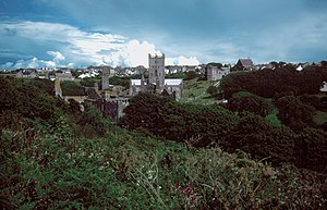
St. Davids (Welsh: Tyddewi) is a small town in Pembrokeshire, Wales. The place is within the national park Pembrokeshire Coast National Park in the hilly valley of the Alun River and is about 1.5 km from the coast of St. Brides Bay. The place is the smallest "cathedral city" in the United Kingdom.
background
getting there
Due to its location in the far west of Wales, airports and ferry ports (to the continent) are quite far away. The closest major towns are Haverfordwest (16 mi / 25 km) and Fishguard (ferry port to Ireland, 16 mi / 25 km).
By plane
- Cardiff (approx. 190 km away), is served from Berlin, Frankfurt am Main, Hamburg, Cologne-Bonn, Munich and Nuremberg, among others.
- Bristol Airport (approx. 250 km away), is used by Berlin Brandenburg, Frankfurt am Main, Hamburg and Munich approached.
- London Heathrow (approx. 400 km away), is used by Berlin Brandenburg, Dresden, Dusseldorf, Frankfurt am Main, Hamburg, Munich and Stuttgart approached.
By train
The nearest train station is in Haverfordwest. The trains are from Arriva Trains Wales operated. There are connections to Milford Haven, Swansea, Cardiff Central and Hereford, among others.
By bus
- Line 411: Haverfordwest to St. Davids / Fishguard
- Line 413 Fishguard to St. Davids
In the street
St. Davids is on the A487 which leads to Haverfordwest and Fishguard. From Haverfordwest, the A40 runs eastwards via St. Clears, Llandovery along the edge of the Brecon Beacon and Brecon to Monmouth.
- In Brecon, the A 470 branches off to Cardiff.
- In Monmouth the A 466 branches off towards Severn Bridge and Bristol.
- From Bristol via the M4 to London.
By boat
- Dover (approx. 540 km), with DFDS, P&O and My Ferry Link to Calais as well as with DFDS from Dover to Dunkerque
- Portsmouth (approx. 405 km), with Brittany Ferries to Caen, Cherbourg-Octeville, St. Malo and Le Havre as well as with Condor Ferries to Cherbourg
- From Fishguard you can take the ferry Stena Line translated to Rosslare, Ireland.
By bicycle
St. Davids is on Route 4 of the National Cycle Network:
NCN 4: London to Fishguard, across Eton, Bradford on Avon, Bath, Bristol, Chepstow, Newport, Swansea, Tenby and Haverfordwest
On foot
Via the Pembrokeshire Coast Path which follows the coastline for 186 mi. The path begins in Amroth and ends in St. Dogmeals. The Pembrokeshire Coast Path is part of the Wales Coast Path.
mobility

Tourist Attractions

- 1 St David's Cathedral, The Close, SA62 6RH. Tel.: 44 (0)1437 720202 (The Deanery Office), Email: [email protected]. Open: Daily from 9 a.m. to 5.30 p.m.Price: Free entry, donations welcome, £ 1.50 photo permit (available from bookstore).

- 2 Bishop’s Palace, St Davids SA62 6PE. Tel.: 44 (0)1437 720517. Open: March 1 to June 30 and September 1 to October 31, 9.30 a.m. to 5 p.m., July 1 to August 31, 9.30 a.m. to 6 p.m.Price: Adults £ 3.50, Children £ 2.65.
- 3 Oriel y Parc Gallery & Visitor Center, High Street, Saint Davids, SA62 6NW. Tel.: 44 (0)1437 720392, Email: [email protected]. Open: March to October visitor center 9.30 a.m. to 5 p.m., gallery 10 a.m. to 4 p.m. (daily), November to February both 10 a.m. to 4.30 p.m.Price: free entry.
activities
Boat tours
- Voyages Of Discovery, 1 High St, St Davids, SA62 6SA. Tel.: 44 (0)1437 721 911, Email: [email protected]. Various boat tours, including to Ramsey Island. Depart from St. Justinians Lifeoboat Station.Price: Varies by tour, from £ 25 (adults), £ 12 (children).
- Thousands Islands Expedition, Cross Square, St Davids, SA62 6SL,. Tel.: 44 (0)1437 721721. Various boat tours, including to Ramsey Island or Grassholme. Depart from St. Justinians Lifeoboat Station.Open: April 1st to October 31st.Price: Varies by tour, from £ 18.00 (adults), £ 8.50 (children).
- 1 St. Justinians Lifeboat Station (St. David's Lifeboat Station). West of the city.
shop
kitchen
nightlife
accommodation
Camping & Youth Hostel
There are three campsites at the end of Ffordd Caerfai Street:
- Glan y Mor Campsite
- Caerfi Farm Campsite
- Caerfi Bay Campsite
- 1 St. David's YHA, Llaethdy, Whitesands, St David's, SA62 6PR. Tel.: 44 845 371 9141, Email: [email protected]. Open: Reception 8:00 a.m. to 10:00 a.m. and 5:00 p.m. to 9:00 p.m.Price: bed from £ 13, room from £ 35.
- B&B & Hotel
- 2 St David's Cross Hotel, Cross Square, St Davids, SA62 6SP. Tel.: 44 (0) 1437720387, Email: [email protected].
- 3 The Grove ***, High Street, St. Davids, SA62 6SB. Tel.: (0)1437 720341. Price: from £ 105 per room per night.
health
Practical advice
Tourist Information
- Pemrokeshire Coast National Park Visitor Center: see Attractions Oriel y Parc Gallery & Visitor Center
important phone number
- 999 is the emergency number for the police, fire brigade, ambulance and coast guard
Useful websites
Post code: SA 62
Area code: 01437, from abroad 44 1437
trips
- 4 St David's Head
- 5 Coetan Arthur Dolmen
literature
Maps
- St. Davids & Haverfordwest, Ordnance Survey Landranger, Sheet 157, ISBN 9780319231036
Connection sheets (the 3 maps cover the Pembrokeshire Coast National Park):
- Cardigan & Mynydd Preseli, Ordnance Survey Landranger, sheet 145, ISBN 9780319231005
- Tenby & Pembroke, Ordnance Survey Landranger, sheet 158, ISBN 9780319231333
The scale of the maps is 1: 50,000. Sights are listed, as well as pubs, hotels and campsites in rural areas, as well as parking lots. The maps are suitable for hiking and cycling. Older editions are sometimes offered on the Internet and in bookstores; the most recent ones are available directly from the publisher. Costs: approx. £ 8.00 per sheet. If you want maps on a scale of 1: 25,000, you need the corresponding sheets of Ordnance Survey Explorer, approx. £ 8.00
Web links
- http://www.stdavids.gov.uk/ - Official website of St Davids