The Tuniberg is a ridge in the Breisgau.

Regions
Halfway between Breisach and Freiburg he rises Tuniberg from the Upper Rhine Plain. It measures just under 10 km from north to south, and the east-west extension is even more modest at around 3 km. He is considered little brother of the north-west Kaiserstuhls, its highest point at 312 m at the southern tip of the ridge towers over the plain by a little more than 100 m.
places
- 1 Gottenheim


 in the Wikidata database") , a wine growing community, is located on the northern tip
, a wine growing community, is located on the northern tip
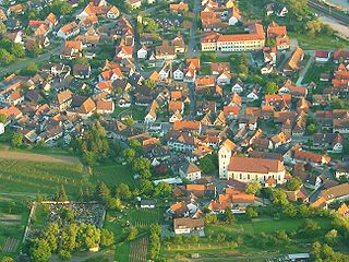
The towns belonging to Freiburg are on the eastern flank 2 Waltershofen![]()
![]()
![]() ', 3 St. Nicholas, 4 Opfingen
', 3 St. Nicholas, 4 Opfingen![]()
![]()
![]() , 5 Tiengen
, 5 Tiengen![]()
![]()
![]() Tiengen and 6 Munzingen
Tiengen and 6 Munzingen![]()
![]()
![]()
.jpg/350px-Waltershofen_(Freiburg).jpg)
- On the south side are the Breisacher Districts 7 Oberrimsingen and 8 Niederrimsingen .
- the independent community 9 Merdingen lies in the west.


background
The Tuniberg differs from the nearby Kaiserstuhl mainly in the nature of the soil. While the Kaiserstuhl is of volcanic origin, the Tuniberg consists of limestone with layers of clay and loess. The Breisgau and thus also the Tuniberg are among the warmest regions in Germany, the area is a well-known wine-growing area, asparagus is also to be mentioned as a special culture.
language
In addition to standard German, Alemannic is also spoken here.
getting there
- The Tuniberg is easily accessible via the connection points
 62 Freiburg-center, 63 Freiburg-Süd and 64 Bad Krozingen the Autobahn A5.
mobility

Tourist Attractions
- 1 Erentrudiskapelle The steep path to this landmark of the Tuniberg is arduous, but it is worth every effort, because from here you have a wonderful view over the Rhine plain to the peaks of the Black Forest and the Vosges. Once a field chapel and since around 1000 pilgrimage site of St. Erentrudis, abbess and patron saint of Salzburg. Already abandoned to decay after being damaged in various wars, it was restored by 14 men from nearby Munzingen and inaugurated again in 1879. The light-flooded small interior is covered by a faceted ceiling and contains the figure of the patroness who holds a model of the chapel in her hand.
activities
- Popular sports are here Cycling, Mountain bike and Inline skates
- Walks in the vineyards with great views of the Southern Black Forest, Kaiserstuhl and Vosges
trips
- 2 St. Anne's Chapel between Wasenweiler and Ihringen
- 3 St. Vitus Chapel between Wasenweiler and Ihringen: Built in the 14th century, restored in 2010. For details see St. Vitus at Wikipedia.
- 4 St Pantaleon pilgrimage church within Niederrotweil: for details see St. Pantaleon at Wikipedia
- 5 Catherine's Chapel on the Katharinenberg: the 493 m high mountain above Endingen and Amoltern is the fourth highest elevation of the Kaiserstuhl. Here is a small excursion restaurant. The 22 m high observation tower can be climbed and rewards the ascent with a wonderful view of the Vosges, the Black Forest and the Rhine plain. 1402 first documented mention, destroyed during the French Revolution and rebuilt in the 19th century with funds from the Endingen residents. Inside the ceiling painting of St. Catherine of Alexandria, made by the Endingen church painters Max and Alexander Stertz.
_jm6818.jpg/240px-St._Vitus_(Wasenweiler)_jm6818.jpg)