The Kaiserstuhl is a small mountain in the Breisgau West of Freiburg. It's right in the middle of that Upper Rhine Plain near the border to France.

background
The mountains and hills that can still be seen today are the remains of a large volcano - that is why the Kaiserstuhl is sometimes only referred to as "a mountain". On its sunny slopes, red and white grapes ripen, the wine of which can be found in many Broom farms in the villages and small winemaking towns around the Kaiserstuhl.
The Kaiserstuhl extends almost to the west in the west Rhine, of which he is through the Rheinauen is separated. In all other points of the compass it is surrounded by fertile farmland, on which mainly vegetables, corn and fruit are grown.
On the Kaiserstuhl itself, wine grows in terraces almost everywhere. On the northern slope there are beech forests, and in a few places in the interior mixed forest or hedges, otherwise the landscape is open. The places are in the core of the crater, and at the foot of the mountain there are wine-growing villages. T. have retained their original character.
places
&groups=Maske,Track,Aktivitaet,Anderes,Anreise,Ausgehen,Aussicht,Besiedelt,Fehler,Gebiet,Kaufen,Kueche,Sehenswert,Unterkunft,aquamarinblau,cosmos,gold,hellgruen,orange,pflaumenblau,rot,silber,violett)
- 1 Burkheim am Kaiserstuhl


 in the Wikidata database") am Kaiserstuhl is a beautifully restored wine-growing town, it is a district of Vogtsburg
am Kaiserstuhl is a beautifully restored wine-growing town, it is a district of Vogtsburg - 2 Endingen am Kaiserstuhl
 - Small town on the northern edge of the mountains, here the "premium hiking trail" Kaiserstuhlpfad begins
 - 3 Your singing - is located on the particularly mild southern edge of the mountains, is supposedly the warmest place in Germany
- 4 Riegel at the Kaiserstuhl
- 5 Sasbach am Kaiserstuhl
- 6 Vogtsburg in the Kaiserstuhl - The districts of the municipality are in the heart of the mountains. With 1,400 hectares, Vogtsburg is the largest wine-growing community in Baden-Württemberg in terms of area.
- 7 Wyhl am Kaiserstuhl


Other goals
- 8 Breisach on the Rhine - at the southwestern foot of the Kaiserstuhl
- Breisacher St. Stephansmünster on the Burgberg
- Museum of City History in the Rheintor
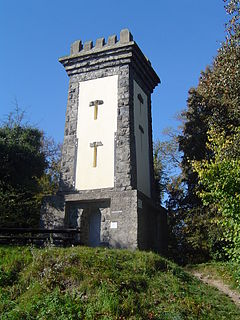
- Radbrunnenturm, Hagenbach Tower, Blue House

getting there
By plane
The Kaiserstuhl is about 50 km north of the airport EuroAirport Basel-Mulhouse-Freiburg![]()
![]()
![]()
![]() (IATA: BSL, MLH, EAP). From there you take the airport bus to Freiburg and change there at the station to the Breisgau S-Bahn.
(IATA: BSL, MLH, EAP). From there you take the airport bus to Freiburg and change there at the station to the Breisgau S-Bahn.

By train
With long-distance transport is Freiburg (Breisgau) central station the nearest ICE / IC train station. From there, you can take the Breisgau S-Bahn to reach the Kaiserstuhl area in less than 30 minutes.
The Kaiserstuhl is owned by the Breisgau S-Bahn Circled every hour or half an hour. In Riegel-Malterdingen station there is a connection to regional traffic on the Rhine Valley Railway.
From France you can take the train to Colmar. A bus leaves from there several times a day Breisach, where you can change to other bus lines or the Breisgau S-Bahn.
In the street
The Kaiserstuhl can be reached by car via the A5 motorway (Riegel exit) and the B31 federal road from Colmar (France) via the D417.
Of Freiburg it is 40 to 80 minutes by bike (depending on the speed and destination).
mobility
The railway lines connect all places on the mountains in a ring. You can combine long-distance hikes in the Kaiserstuhl very well with a train journey.
In the central valley (the former crater) buses run by Südbaden-Bus GmbH to the districts of Vogtsburg.
Incidentally, the steam-powered museum train runs on the Kaiserstuhlbahn between Riegel, Sasbach, Burkheim and Breisach on special dates "Vine lover".
Tourist Attractions

.jpg/214px-Loesshohlgasse_(Kaiserstuhl).jpg)


.jpg/320px-Wasenweilerstraße,_Ihringen_(2008).jpg)

Mountains and viewpoints
- 1 Neunlindenturm: The stone lookout tower is 556 m high on the Totenkopf, the highest mountain in the Kaiserstuhl at 557 m. Due to the transmission tower (not accessible), the skull is a landmark that can be seen from afar.
- 2 Acorn tip tower: The radio and observation tower, built in 2006, is 520 m high on the mountain of the same name. The 42.5 m high structure, a cell phone tower operated by network operator O2, has a viewing platform at a height of 28 m. You have to be a bit free from giddiness to climb the open steel lattice tower. Anyone who has overcome this problem can expect one Panoramic view over almost the entire Kaiserstuhl, as well as views to the Black Forest and the Vosges. Of Eichstetten from there a geopath leads to the tower.
- Arrival by car: 1 Parking lot for hikers "Vogelsang" in the pass area of the Oberbergen - Bötzingen road. From here you walk about 1.2 km over the western flank of the Eichelspitze to the tower (around 150 meters in altitude). Along this route, boards provide information on the geology of the Kaiserstuhl.
- 3 Katharinenberg with Katharinenkapelle: The chapel, consecrated in 1862, is located in the northern part of the Kaiserstuhl. A first church was mentioned here as early as the 14th century. The 492 m chapel is accessible from Endingen via hiking trails.
- 1 Viewpoint Pavillon Mondhalde north of Oberrotweil: From the vantage point, which is around 350 m above sea level, you have a beautiful view of the central area of the Kaiserstuhl. The rest area can be reached both from Oberrotweil and from Bischoffingen on foot on roads through the vineyard terraces.
- 2 Most beautiful wine view Baden 2020 directly on the road from Königschaffhausen to Oberbergen. The parking lot bears the title "Most Beautiful Wine View Baden 2020"
- 4 Lenzenberg Above Ihringen with gastronomy: South of the Kaiserstuhl
- 5 BadbergBadberg nature reserve: The 435 m high, largely bare elevation lies in the heart of the mountains. The semi-arid grassland and dry grassland are home to many rare plants (e.g. orchids) and insects. The climate is very mild, so that many heat-loving plants and animals have settled here. For example, the praying mantis, which is almost non-existent in Germany, is found here. A nature trail with display boards opens up the area.
- Arrival by car up to 2 Parking lot for hikers in the area of the Oberbergen - Bötzingen road. From here, hiking trails open up the area. Good to know: just a few meters from the car park, you can cool off a bit at a water treading area in the heat.
Museums
- Kaiserstuhl Wine Museum, in Vogtsburg in the Kaiserstuhl.
- Eichstetten village museum at the Kaiserstuhl. Tel.: (0)7663 50148 (Info: Ms. Hornecker). On the ground floor: the village school through the ages. On the upper floor there is a permanent exhibition on the history of the village of Eichstetten with excavation finds. The museum is not open all the time.Price: Free entry, offers for children.
- Cherry Museum, in Königschaffhausen. Many exhibits on cherry cultivation are on display and show work processes for cultivating and processing cherries, especially the "Black Queen", a heart cherry.Open: on the 1st Sunday of the month from 4 p.m. to 6 p.m.
- Front Austria Museum, Adelshof 20, 79346 Endingen. Tel.: (0)7642 689990 (Info). The two-story half-timbered house with late Gothic frescoes (1495), built at the end of the 15th century, is a gem in the medieval urban area. A museum exhibition on the topic of Front Austria - from Rudolf von Habsburg to the dissolution of the Front Land.
- Kaiserstuhl Local History Museum, in Endingen.
- Dairy Museum, in Endingen.
- Local museum, in Endingen-Kiechlinsbergen.
- Ihringen local history museum. The museum offers a comprehensive insight into the typical and poor life of a winegrower and into the secrets of old handicrafts and all kinds of special features and rarities.
- Nature center Kaiserstuhl, in Ihringen. Tel.: (0)7668 710880 (Info). Compact exhibition on the nature and geology of the Kaiserstuhl, an interactive terrain model, children's reading corner.
- Archaeological Museum, in bars. Part I. shows the history of Riegel in Roman times, part II. Is dedicated to the aerospace industry.Open: Sun 11 a.m. - 5 p.m.
- Art gallery messmer. Tel.: (0)7642 9201620 (Info). Founded in 2009 in the historic building of the former brewery.
- Sasbach Museum. Tel.: (0)7642 9101-0 (Info). Opened on May 30, 2015 with changing themed exhibitions.
- Menton local history museum, in Teningen. Tel.: (0)7641 49421 (Info). Well-preserved large courtyard from the 18th century.Open: Mar - Oct every first Sunday from 2 p.m. to 5 p.m.
- Corkscrew Museum Kaiserstuhl, in Vogtsburg-Burkheim. The only museum of its kind in Germany.Open: Wed - Sat 11 a.m. - 6 p.m.
More Attractions
- Remigius Church Merdingen: The late baroque church was built in 1738-1741 by the Teutonic order builder Johann Caspar Bagnato, with its interior design, is one of the most beautiful baroque churches in southern Baden.
- Liliental arboretum: The green valley lies on the southern slope of the Totenkopf. Various tree species such as the sequoia grove, the oak collection, the yellow pine collection and many other species are worth seeing in the wide, natural complex. In addition to the experimental areas of the trees, there are also rare orchid species. The 70 hectare test facility belongs to the Forestry Test and Research Institute of Baden-Württemberg. Three circular routes between 1.5 and 5.5 km in length open up the area (official leaflet for the system). The forest restaurant ["Zur Lilie"] near the parking lot invites you to refresh yourself. A visit to the Liliental can also be combined with a hike to the lookout tower on the skull. From the parking lot you walk the Hüttenweg about 3 km easily with about 300 meters in altitude.
- The approach to Liliental is via Ihringen to 3 parking spot.
- Old town of Burkheim: The small wine-growing town has a beautifully restored old town (info).
- Old town of Endingen
activities
hike
In the Kaiserstuhl-Tuniberg area there is an approximately 500 km long network of hiking trails and themed trails. 9 thematic axes and numerous local theme trails are integrated in this network.
For example, there is also a hiking trail along the former rim of the crater, which runs between beech forest and vineyards in many places beautiful views offers. A hiking map is in the section literature specified.
Kaiserstuhlpfad
The 21.7 km long quality hiking trail leads on natural paths through the diverse natural landscape of the former volcano. The route has received the demanding seal of "Quality Trail Wanderable Germany". The path has a very demanding elevation profile
- Route:Endingen - Erletal - Katharinenkapelle - Eichelspitzturm (radio and observation tower built in 2006 at 520 m height) - Vogelsang Pass (approx. 380 m) - Neunlindenturm (observation tower at Totenkopf at 556 m, the highest mountain in the Kaiserstuhl) - Eichgasse - Vogtsburg-Bickensohl - Jägerbuck - Dulltalhütte - Lenzengasse - Your singing
Swimming and water sports
In the center of the mountain near Oberrotweil there is a 1 Outdoor pool.
There are several bathing lakes around the Kaiserstuhl.
kitchen
Some dishes from Baden cuisine can be found in the Koch Wiki. Please only provide general information on the cuisine in the region here. Gastronomy is listed in the local articles.
nightlife
security
climate

The Kaiserstuhl is Germany's warmest area. It has a hot, dry climate that is otherwise only found in the Mediterranean region.
So spring is the first to arrive here in Germany. On average, the crocus blooms on the Kaiserstuhl and in the Breisgau as early as March 1st. Statistically speaking, spring then advances 30 km north-east from Breisgau every day. In Mecklenburg-Western Pomerania, about 1000 km away, the crocuses usually only bloom towards the end of March.
Due to the Vosges to the west, there is very little rainfall in the Kaiserstuhl, at 600 - 700 mm. But the sun shines a lot with 1720 hours.
The high altitudes of the mountains between 400 and 500 m altitude have an extremely extreme climate (relatively cold winters and very hot summers). The average temperature here fluctuates around 18.5 degrees Celsius every year.
Weather forecast
- Weather station "Ihringen" of Meteomedia AG from Jörg Kachelmann 4-day forecast. Ihringen on the southern slope of the Kaiserstuhl is the warmest place in Germany, according to meteorologists.
trips
Adjacent areas: The Kaiserstuhl is in the middle of the Breisgau between Rhine (in the west) and Black Forest (in the East).
It borders in the north and south Upper Rhine Plain on, in the south joins the surrounding Breisgau the Markgräflerland at.
In the west, across the Rhine in the Alsace (in France) lies the Sundgau.
Sights close-by: The place is not far from the Kaiserstuhl Breisach on the Rhine with a great church and the Rheinauen with many quarry ponds that invite you to swim.
The cities Freiburg (approx. 20 km east), Colmar (approx. 30 km west), Basel (approx. 60 km south) and Strasbourg (approx. 80 km north) are very worth seeing.
literature
- Hiking map Kaiserstuhl-Tuniberg Topographic map on a scale of 1: 30000; The map shows the hiking trails and themed trails (a total of 34 tour suggestions). ISBN 978-3-935806-13-8 (1st edition 2008); published for € 4.95 by map.solutions GmbH Karlsruhe
Art at the Kaiserstuhl, Forays through a cultural landscape, ed. Hans-Otto Mühleisen, Kunstverlag Josef Fink, 2nd edition 2008, ISBN 978-3-89870-284-3
Web links
- Kaiserstuhl-Tuniberg Tourism e.V. - official, regional tourism website