The Upper Rhine Plain (also called Rheinebene or Oberrheingraben) is a rift valley system and reached Germany (Swimming, Rhineland-Palatinate and Hesse), France (Alsace), Switzerland (BaselThis article is intended to provide a rough guide to the area. More detailed information should be placed on the articles of the subregions.

Regions
Area-wide sub-regions

- Wetterau
- Rhine Main Area (overlapping with Rheingau, Rheinhessen, Hessisches Ried)
- Rheingau
- Hessian Ried
- Rheinhessen (Sub-region)
- Front Palatinate
- Baden Rhine Plain
- Electoral Palatinate (Sub-region)
- Hardtwald and Bruhrain
- Central bathing (Sub-region)
- Ortenau (Sub-region)
- Breisgau (Sub-region)
- Markgräflerland (Sub-region)
- Alsace (Sub-region)
- Basel city
further sub-regions

- Rhine valley
- German Wine Route, Part of the Vorderpfalz
- Mountain road, belongs partly to the Hessian Ried and the Electoral Palatinate
- Rhine-Neckar area, Part
- Alsatian wine route
- Baden Wine Route
- Kaiserstuhl
places


"Tourist locations and cities" with supra-regional importance (ordered by North to south):
- Frankfurt am Main
- Wiesbaden
- Mainz
- Darmstadt
- Worms
- Bensheim
- Heppenheim
- Weinheim
- Lorsch
- Mannheim
- Ludwigshafen on the Rhine
- Heidelberg
- Freinsheim - City wall
- Neustadt an der Weinstrasse
- Bruchsal
- Speyer
- Landau in the Palatinate
- Karlsruhe
- Ettlingen
- Wissembourg (F) in Alsace
- Rastatt
- Baden-Baden
- Strasbourg (F) in Alsace
- Riquewihr (F) in Alsace
- Colmar (F) in Alsace
- Freiburg in Breisgau
- Breisach at the Kaiserstuhl
- Basel (CH)
Other goals
- Rhein-Main-Airport Frankfurt
- Holiday Park Hassloch
- Europe Park Rust
- Kaiserstuhl in Breisgau
background
The Upper Rhine Plain is a rift valley system. It is characterized by viticulture and fruit growing at the transition to the low mountain ranges, and of course by the Rhine, which is supplemented in France by the Rhine Lateral Canal and with this forms a floodplain landscape, in the Palatinate, Rheinhessen, North Baden and Hesse was straightened and with the "Altrheinarmen" forms a differently designed floodplain landscape.
Culturally, the region has been characterized by relatively dense settlement since pre-Roman times, combined with urban centers and traffic routes of all kinds.
Nevertheless, there are larger forest areas not only in the Rhine lowlands themselves, but also at greater distances, which are ideal for cycling and hiking.
Neighboring regions are:
- Middle Rhine Valley
- Nahe valley
- Thunder Mountain
- Palatinate Forest
- Vosges
- Swiss Jura
- Black Forest
- Kraichgau-Stromberg
- Odenwald
- Kinzigtal
- Vogelsberg
- Hunsrück
- Taunus
Above Basel one speaks of Upper Rhine, below the mouth of the Middle Rhine
language
- German, among others, in the forms of Palatinate, Baden, Alsatian and Basel German
- French
getting there
By plane
The most important airports are: Frankfurt am Main, Strasbourg and Basel
By train
Frankfurt am Main, Mannheim, Strasbourg and Basel are important hubs for rail traffic and are accordingly well connected to national and international lines. There are also many other train stations for ICE, IC and regional traffic.
By bicycle
- Rhine cycle route
- Rhine Valley Path · in Baden-Wurttemberg
- Hess. Long-distance cycle route R8: Westerwald - Taunus - Bergstrasse in Hesse
By boat
The Rhine is navigable. The arms of the Old Rhine are also navigable for sport boats; there are many mooring options for amateur boaters.

mobility
Tourist Attractions
A selection of nationally important sights:
- Heidelberg lock
- Wormser Dom
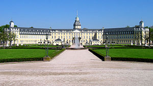
- Karlsruhe lock
- Luisenpark Mannheim
- Speyrer Dom
- Kühkopf-Knoblochsaue nature reserve - is the largest floodplain protection area on the Upper Rhine. It is located about 30 km south of Frankfurt am Main. There are many hiking and cycling opportunities in the area.
- Bertha Benz Memorial Route - on the trail of the world's first long-distance journey in an automobile
activities
- Shopping in Frankfurt am Main, Mannheim, Neustadt, Speyer, Karlsruhe, Strasbourg, Basel
- Wine tasting and buying in the wine-growing regions Rheingau, Rheinhessen, Pfalz, Bergstrasse, North Alsace, Baden, Alsace
- Water sports: Swimming in many quarry ponds, boating on the Rhine and the arms of the Old Rhine
- bike tours
kitchen
security
In the Rhine lowlands, mosquito plagues are to be expected, especially after floods in the warm season.
climate

The climate is warmer and less rainfall than in most regions of Germany. This is especially true for the Kaiserstuhl.
Spring is the first to arrive in the Rhine lowlands in Germany. On average, in Breisgau near Freiburg, for example, the crocus blooms as early as March 1st. Statistically speaking, spring then advances 30 km north-east from Breisgau every day. In Mecklenburg-Western Pomerania, about 1000 km away, the crocuses do not usually bloom until the end of March.
Due to the location of the ditch, however, inversion weather patterns are to be expected, especially in winter. In summer there is an increased tendency to thunderstorms in the Rhine lowlands when the weather is hot and humid. You can escape the tropical heat by taking a trip to the neighboring mountains.
trips
- In the Black Forest
- In the Vosges