The Hunsrück is a low mountain range in Rhineland-Palatinate and in Saarland. With the 816 m high Erbeskopf Incidentally, the Hunsrück is also the highest mountain in Rhineland-Palatinate.

In 2015 the Hunsrück-Hochwald National Park set up.
Regions
Neighboring regions
Subregions
Rhineland-Palatinate
- The article excludes all areas of the country Rhineland-Palatinate one that lie north of the Nahe, west of the Rhine and south of the Moselle and are not directly in the area of the river valleys mentioned. The north bank of the Near above the confluence of the Glan assigned to the Hunsrück.
- Also the territory of the country Rhineland-Palatinate west of the Saar is described in this article.
Saarland
- The article roughly covers the area of the Saarland part of the "Saar-Hunsrück" nature park with the neighboring cities.
Saar valley
- The western border of the Hunsrück is formed by the Saar valley.
places

- 1 Hermeskeil


 in the Wikidata database")
- 2 Kell by the lake
- 3 Thalfang at the Erbeskopf
- 4 Morbach
- 5 Kirchberg / Hunsrück
- 6 Simmern / Hunsrück
- 7 Kastellaun
- 8 Rheinböllen
- 9 Emmelshausen
- 10 Idar-Oberstein (Nahe valley)
- 11 Kirn (Nahe valley)
- 12 Birkenfeld (Nahe)
- 13 Losheim am See
- 14 Merzig (Saar valley)
- 15 Mettlach (Saar valley)
- 16 Saarburg (Saar valley)


Other goals
background
The Hochwald-Hunsrück National Park was established in the Hunsrück in 2015 (see also official site for the project).
language
Moselle Franconian (Hunsrückish). High German is understood everywhere and spoken with a strong regional coloring. English is widely understood and spoken.
getting there
By plane
- The is located almost in the center of the Hunsrück Frankfurt Hahn Airport, which is especially used by low-cost airlines. Unfortunately it has no train connection yet; the connection to other Hunsrück communities such as Morbach is particularly bad.
By train
- The cities on the Nahe, Saar and Moselle can be reached by train, e.g. Idar-Oberstein, Merzig, Cochem
By bus
- Morbach has bus connections to, among others Idar-Oberstein and Bernkastel-Kues
- Simmern is among other things off Bingen directly accessible.
Further links are under the website "The beat" from the Ministry of the Interior, Sports and Infrastructure.
By bicycle
The Hunsrück cycle paths are connected to numerous cycle routes in the adjacent river valleys:
The Hunsrück cycle routes are shown under activities.
mobility
Tourist Attractions
Mountains, observation towers and points

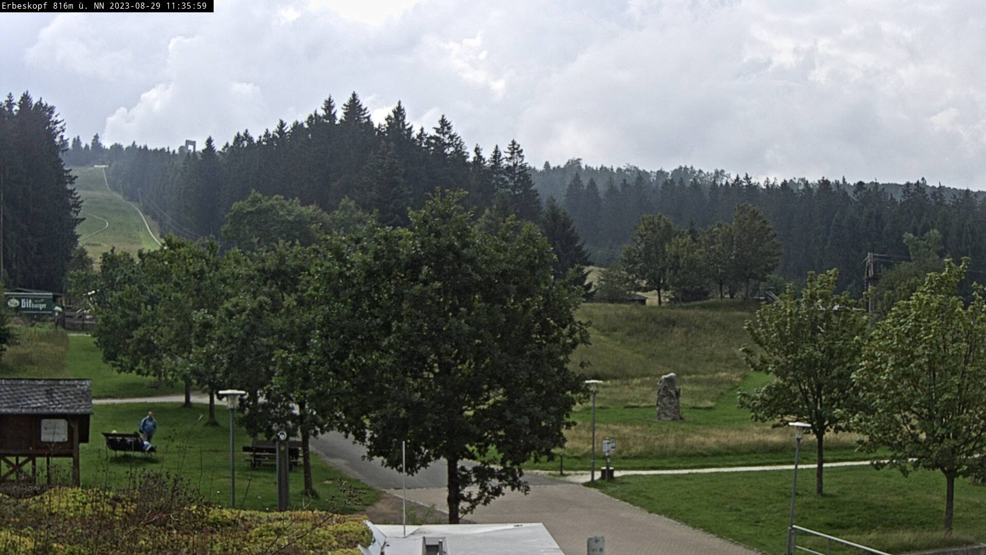
- 1 Erbeskopf - With 816.32 m the Erbeskopf is the highest mountain in the Hunsrück. The survey is interesting both in summer and in winter. For more information see article to the mountain.

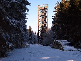
- 2 Idarkopf - The 745.7 m high elevation is a prominent mountain in the central Hunsrück. The stands for Fernblick lovers 28 m high, freely accessible 3 Idarkopf tower to disposal. But even from the former ski slope you have a lovely east view.

- Because of the south-facing location, winter sports operations on the Idarkopf were discontinued. An extensive bike park is currently being planned (04/2019).
- 4 Head of salt and 5 Salzkopfturm - The 24 m high open wooden tower stands on the 627.6 m high salt head northwest of Bingen. From the freely accessible building you have a wide panoramic view over the forests of the Hunsrück and also into the Middle Rhine Valley. The military erected the first wooden tower as early as 1899, which was renewed in 1922. The current tower was built in 1973. In 1997 the structure had to be damaged due to the Ross ant to be redeveloped. [1] In the summer of 2009, parts of the tower had to be renewed again due to rot in the load-bearing structure. This project was completed on June 4, 2010 and the building is accessible again.


- - Directions: The
 at the
  Leave Stromberg. From here keep in the direction of Daxweiler. Park the car in the area of the forester's lodge Lauschhütte. From here you walk about 1 km to the tower.
 - - Miscellaneous: In the Lauschhütte there is a place to stop for a break. If you want, you can have a head for heights in the affiliated Climbing forest work out. There is also a playground. On the way to the tower you come to the Toboggan run past. The approx. 200 m long forest meadow in the north has a height difference of approx. 35 m.

- 6 Rothenburgberg With 7 Hattgenstein observation tower - The futuristic wooden tower, built in 2006, is 28.6 m high and at a height of around 590 m. At a height of 21 m it has a covered viewing platform. On a clear day, you have a beautiful view in east direction to the North Palatinate Bergland from the tower. In 2006 the tower received the wood construction award from the Ministry for the Environment, Forests and Consumer Protection of Rhineland-Palatinate.[2]

- - Location: at the former sports field in Hattgenstein-Birkenfeld
- - Directions:
 to the Hattgenstein junction (12 km from the
  4 Birkenfeld removed). After about 1 km you will reach the town of Hattgenstein. Here at the entrance to the village right into the Pine path turn in.
 - - Close to the tower, the Rothenburghütte, a rustic but well-attended refreshment point.
- 8 Hochsteinchen - South of Rheinböllen is written on the 648 m high elevation an 18 m high steel lattice tower. According to the Wikipedia article, the tower is already partially overgrown (mainly affects the view to the south). Furthermore, the tower has been in the area of wind turbines since 2012 Wind farms Ellern, which is partly quite close to the building.

Museums
Museums of national importance:
- 9 German Gemstone Museum, Hauptstrasse 118, 55743 Idar-Obersein (in the Idar district). Tel.: 49 6781 900980, Fax: 49 6781 900 981, Email: [email protected]. The exhibits of the German Gemstone Museum are probably unique in the world on this scale. There are regular special exhibitions. Regardless of the exhibits, the building of the gemstone museum is worth a separate look and special attention: The museum is housed in a representative villa from 1894, which is one of the most important examples of the numerous villas of the Idar jewelry and gemstone dealers. The villa was built by the pearl dealer Karl August Purper. The building, built in the style of historicism, was also called "Purple Castle" because of its splendor.Open: February 1st to April 30th: daily 10 a.m. - 5 p.m.; May 1 to October 31: daily 9.30 a.m. - 5.30 p.m. November 1st to January 14th; daily 10 a.m. - 5 p.m. 15th to 31st January: closed.Price: Graduated prices for different groups of people. Standard price adults: € 7.00 uro.

- 10 Hunsrück Museum Simmern, New Castle, Schloßplatz, 55469 Simmern (Hunsrück). Tel.: 49 6761 7009, Fax: 49 6761 908 044, Email: [email protected]. Regional museum with changing special exhibitions on different topics around the Hunsrück.Open: March to December: Tue-Fri: 10 a.m. to 1 p.m. and 2 p.m. to 5 p.m., Sat-Sun: 2 p.m. to 5 p.m. Closed: January and February as well as Good Friday, Easter, Whit Monday, Christmas and New Year's Eve.Price: Adults: € 2, children € 1. Group rates available.
- 11 SS special camp Hinzert - memorial (Hinzert concentration camp), At the memorial, 54421 Hinzert-Pölert. Tel.: 49 6586 992 493, Fax: 49 6586 992 494. Initially a police detention camp for delinquent workers from the Westwall, from 1940 the camp became a concentration camp for mainly Luxembourgish, but also Belgian, French, Dutch and a few German prisoners. The Hinzert memorial is a national memorial for the neighboring country of Luxembourg.Open: Tue-Fri: 9 am–1pm and 2pm – 5pm; Sat, Sun and public holidays: 2 pm–5pm.
Wildlife parks, game reserves and amusement parks
- 12 Hunsrück Wildlife Protection Park, Wildlife Protection Park 1, 55494 Rheinböllen (The park is good about that to reach ( 45 Rheinböllen), then via the K 44 towards Erbach.). Tel.: 49 6764 1205, Email: [email protected]. At Rheinböllen with falconry. Kiosk and bistro on the premises.Open: mid-March to the end of March: daily. 9 a.m. - 7 p.m., admission until 6 p.m. April to August: daily. 9 a.m. - 8 p.m., admission until 7 p.m. September and October: daily 9 a.m. - 7 p.m., admission until 6 p.m. November to mid-March: working days from 10 a.m. until dark. On weekends, public holidays and during the Christmas holidays from 9 a.m. until dark.
- 13 Wildlife enclosure Wildenburg, Wildenburgerstrasse 22, 55758 Kempfeld (From the main street in Kempfeld (L 178) opposite the Gartenhotel Hunsrücker Fass, turn into Wildenburgstrasse and follow it to the large car park.). Tel.: 49 6786 7212. The game enclosure is located right next to the Wildenburg castle ruins near Kempfeld and shows a variety of animals on an area of 42 hectares. The park has had its own wolf enclosure since 2015, in which five wolves reared on site live. Daily feeding of the wolves at 4 p.m., the keepers are often available to answer questions from visitors. Nice circular route on paved but not tarred ground along the individual enclosures. The short version with small differences in height is also suitable for prams; the longer variant has a steep incline.Open: Open all year round, 365 days / year. Admission: 9 a.m. to 5 p.m., the exit is open until dark. There is a late exit (signs).Price: Standard prices: under 16 years: 4 €, over 16 years: 6 €. Discounts for families and groups.
miscellaneous
- 14 Geierlay suspension bridge (near Mörsdorf around 10 km west of Kastellaun). The 360 m long rope bridge was inaugurated on October 3, 2015. The 1.4 m wide footbridge crosses a brook valley at a height of 90 m. The construction costs amounted to € 1.2 million.

activities
hike
In the sparsely populated Hunsrück it is not certain that inns or other places to stop for a break can be found along the way. It is therefore advisable to bring enough food and drinks with you.
No18.jpg/300px-Sonnwaldsteig(Stage5)No18.jpg)


No10.jpg/300px-Sonnwaldsteig(Stage5)No10.jpg)
No07.jpg/300px-Sonnwaldsteig(Stage5)No07.jpg)
No05.jpg/300px-Sonnwaldsteig(Stage6)No05.jpg)
No07.jpg/300px-Sonnwaldsteig(Stage6)No07.jpg)
No08.jpg/300px-Sonnwaldsteig(Stage6)No08.jpg)
- Saar-Hunsrück Climb. The 410 km long hiking trail connects the Saarschleife at Mettlach with the gem city Idar-Oberstein. Alternatively, you can also go to the Roman city trier hike. Route in OpenStreetMap.

- Dream loops on the Saar-Hunsrück-Steig. All over the Hunsrück there are so-called dream loops in the area of the Saar-Hunsrück-Steige 76 (status: 03/2019), which allow a half-day or full-day circular hike in particularly beautiful locations. Often the dream loops are dedicated to a specific topic. There are different levels of difficulty to be found. Some of the dream loops have received high awards (hiking trail of the year or similar). For information and as a basis for planning here an overview is available.
- Soonwaldsteig. 84 km long premium trail with a higher proportion of smaller trails. The route connects Kirn an der Nahe with Bingen am Rhein as an extensive ridge path. More than 80% of the path leads through forests. The southern area of the route from Kirn to Lützelsoon is particularly interesting. Here the route often runs on scenic paths with attractive landscape views such as B. at the Kellenbachtal. According to the Wikipedia page, stages 5 and 6 often run on wide, gravel roads in the eastern area. At Rheinböllen it is partially heard. At the Hochsteinchen, the route also leads through the Ellern wind farm. The easternmost section of the route from the Salzkopf towards the Middle Rhine Valley, which the Soonwaldsteig accompanies on its final kilometers, is then more attractive. Route in OpenStreetMap.
No10.jpg/350px-Sonnwaldsteig(Stage5)No10.jpg)
- Hunsrücker Windweg. 5 km long nature trail with 11 stations on the subject of wind power, which can be found at Thalfang. 1 Parking lot for the Hunsrücker Windweg.
- Rheinhöhenweg. on the left bank of the Rhine.
- Rheinburgenweg. Of Bingen over the Vierseeblick Boppard to Koblenz-Güls at the Moselle.
To go biking
The Hunsrück is criss-crossed by small, little-traveled back roads and countless field, forest and forest roads that are ideal for cycling. If the field, forest and forest roads are not already explicitly approved for bicycles (additional sign), use is generally tolerated (prohibition sign = disclaimer). Within the Hochwald-Hunsrück National Park, there is no tolerance on the trails and paths marked as hiking trails. The national park rangers monitor compliance with this ban.
- Hunsrück cycle path (old name too Rhine-Hunsrück-Saar cycle path) - 155 km, opens up the central Hunsrück in an east-west direction from Niederheinbach in the Middle Rhine Valley via Rheinböllen, Simmern, Kirchberg, Meinhardt, Morbach, Erbeskopf, Hermeskeil, Kell am See, Zerf and Saarburg
- Schinderhannes cycle path - Attractive railway route with moderate gradients, the 37 km in the Hunsrück from Emmelshausen to Simmer runs on a paved route. A leisure bus brings the cyclist back regional cyclists. The cycle path begins at the Emmelshausen train station. Route in OpenStreetMap
- Ruwer-Hochwald-Radweg - 49 km from the Moselle to the Hochwald, 505 m up, 95 m down. Better variant: Arrival by bike bus (on weekends and during holidays) from trier to Hermeskeil and the route in reverse: 95 m ascent 505 m descent! Route in OpenStreetMap
- Erbeskopf Trail and Bike Park - The area of the ski area at the 816 m high Erbeskopf including the lifts is used as a trail and bike park for cyclists on Saturdays and Sundays from April to October. Detailed information can be found on the operator's website.
See also
Winter sports
Alpine skiing
- Ski area on the Erbeskopf - There are a total of three snow-making slopes on the 816 m high mountain. The ski area with the lifts is used as a trail and bike park for cyclists on Saturdays and Sundays from April to October.
- Ski area on the Idarkopf - The ski area is currently closed (04/2019), the double lifts have been in operation since February 2010 out of order. Since the reconstruction of the south-facing slope is not economically necessary due to the poor snow reliability, the local administration is currently developing a plan for one Bike park. The plans have to go into a new round of approval, as the spatial extent exceeds the original intentions.
- Leisure and winter sports center on the Peterskopf at Nonnweiler - There is a lift with a 360 m long slope at a height difference of 63 m. There is also a 330 m long toboggan run (info). Snow telephone: 06873 - 91134
Nordic skiing
- Ridge trail "Idarwald" - The relatively snow-reliable route runs between the Erbeskopf and the Idarkopf at an altitude of between 650 and 750 m. A trail map is to be found here.
further activities
During the summer months, sporty holidaymakers will find several offers:
- Summer toboggan runs on the Erbeskopf or on Peterberg at Nonnweiler.
- Trail and bike park on the Erbeskopf
- Climbing garden on the Erbeskopf
kitchen
On the one hand, the cuisine of the Hunsrück has its own roots, but is also shaped by the neighboring regions Saarland, Palatinate, Moselle country etc. Further information can be found in the Koch Wiki to find.
The traditional Hunsrück cuisine mainly offers hearty dishes.
- Filled clover (filled dumplings) with bacon sauce are extremely nutritious. Potato dumplings are filled with liver sausage and / or minced meat, with a bacon-cream sauce and sometimes sauerkraut.
- At the Hunsrücker Pan roast marinated pork neck steaks are grilled on a swivel grill over the embers.
- Idar-Obersteiner Spit roast is roasted on a wire rack or on a spit with strong embers and a low flame.
- In the region around Birkenfeld / Nahe is Potato sausage a popular specialty.

Filled: potato dumplings filled with liver sausage, with bacon sauce and sauerkraut.

Pan roast


nightlife
The only relevant nightlife are the animals in the field and forest, which creates a relatively high risk of nocturnal accidents caused by deer movement.
security
There are no known specific risks.
Rescue points in the forest
Particularly in the large forest areas, it can be difficult to describe the exact position in emergencies. By setting up rescue points in the forest, the state forest of Rhineland-Palatinate has set up a company-wide rescue system that can also be used by private individuals. Rescue points were originally developed as starting points in the event of accidents that occur during dangerous forest work by employees of the forest administration, but they can also be used to find people who have had accidents in the forest or who have lost their way through civil joint use. In this way, the rescue points can develop a life-saving function in life-threatening situations. Rescue points are marked by a dark green board with a white cross, the identification of the rescue point and a reference to the emergency number 112. However, it cannot be guaranteed that the own mobile network will actually work at any rescue point. The Rhineland-Palatinate forest administration provides information on their websitethat a free app is also available.
climate
The Hunsrück, which is enclosed by the river valleys of the Rhine, Moselle, Saar and Nahe, has the highest elevation in Rhineland-Palatinate with the Erbeskopf at 816 meters above sea level. Thus, the Hunsrück region includes height differences of around 700 meters with the correspondingly different climatic conditions.
From the river valleys with a wine-growing climate it goes to the winter sports areas on the Erbes- and Idarkopf. While the last snow melts in the Hunsrück in locations above 400 meters, the first signs of spring are already blooming on the Moselle (vineyard peaches, almond trees, forsythia, etc.), when the last grapes are harvested on the Moselle, Rhine and Nahe, the first falls again in the Hunsrück Snow.
In general, it is advisable to take weather protection with you in the high areas of the Hunsrück.
trips
literature
Web links
- Hunsrück tourism - official regional tourism site
- Hunsrück-Hochwald National Park - Website of the Ministry for the Environment, Agriculture, Food, Viticulture and Forests Rhineland-Palatinate
- Soonwald-Nahe Nature Park
- Saar-Hunsrück Nature Park
Webcams
Individual evidence
- ↑Salzkopfturm in the database for Timber construction of the state forests of Rhineland-Palatinate
- ↑Hattgenstein observation tower in the database for Timber construction of the Rhineland-Palatinate state forest