
The Saar rises in two source streams in the Vosges on the 1000 m high mountain Donon on the border of the French departments Bas-Rhin and Moselle. The confluence of the two arms of the river takes place above the city Sarrebourg. From there the route has almost no more inclines. The landscape of the Saar in France is very calm and characterized by numerous lakes. The inner-French border between Lorraine and Alsace is crossed several times before at Sarreguemines the state border to Germany is reached. Below Mettlach the Saar leaves that Saarland and achieved Rhineland-Palatinate. The confluence with the Moselle is in Conc.
Route profile


- Length: 115 km (Saargemünd - Konz), approx. 200 km from Quellen
- Signposting: at least from Sarralbe available and good, beforehand depending on the chosen alternative
- Slopes: From Sarralbe to the confluence with the Moselle near Konz there is only a small incline in the forest near Mettlach.
- Path condition: largely paved, section Gondrexange to Saargemünd good asphalt with occasional longitudinal cracks.
- Traffic load: quite low, short section next to the main road
- Suitable bike: Everyday bike
- Family suitability: not so suitable, as the route is very close to the river and the river is canalized, without banks or railings
- Inline suitability: suitable on the Saar Canal. Mittersheim to Sarreguemines very good
background
Parts of the route are as EuroVelo 5 signposted of the places Strasbourg (at the Rhine cycle route) and Luxembourg city connects. After crossing the German border, the euro route is lost.
The Saar cycle path reaches the countryside
preparation
Select starting point.
getting there

Public transportation
- Sarrebourg can be reached by French railways, on the route Strasbourg-Nancy
- Sarralbe can be reached by French railways
By bicycle
Along the Rhine-Marne Canal from Strasbourg off to Hesse (belongs to Sarrebourg). The route is now as EuroVelo 5 signposted.
Route description with sights
Route on the Sarre Blanche, approx. 40 km
The source is located above the village of Turquestein-Blancrupt, 5 km northwest of the city Schirmeck, Bas-Rhin
Route on the Sarre Rouge, 35 km
- One of the 1 swell is located 20 km southeast of the village of Abreschviller on Tête de Mort (German Totenkopf) at 677 m above sea level. Follow the country road D 44which follows the valley of the Red Saar at times more, at times less steeply.

- 2 Abreschviller


 in the Wikidata database") - the place offers refreshment opportunities. You now use the asphalt bike path on a former railway line that begins here on the left of the Saar, almost to Sarrebourg.
- the place offers refreshment opportunities. You now use the asphalt bike path on a former railway line that begins here on the left of the Saar, almost to Sarrebourg.
.jpg/320px-Abreschviller_depuis_la_roche_du_Moulin_(2).jpg)
- → on the route you can in 3 Lorquin branch off from Voie Verte and take country roads via Landange to Gondrexange. The hilly route saves a few kilometers, but you miss a piece of the Saar.


Saar-Kohlen Canal (alternative Sarrebourg to Harskirchen)
It is advisable to leave the Saar valley for a few kilometers after crossing the Rhine-Marne Canal and drive parallel to the railway line to Gondrexange. Here you will not only find a beautiful swimming pond and campsite, but also the confluence of the Saar-Kohlen Canal (french Canal des Houillieres), which leads past the Stockweiher and Mittersheimer Weiher and only meets again with the Saar Valley at Harskirchen. This is also where you come from Sarre-Union if you have followed the Saar Valley. The cycle path along the canal is of high quality and is scenic and quiet.
- 1 Sarrebourg - Already before the place left, either before the N 4 turning on the sandy, but quite cycle-friendly towpath or behind the railway line on country roads. No signs.
- 2 Hertzing - From here a good, paved bike path on the Rhine-Marne Canal
- 3 Gondrexange - Change of the canal side, approx. 1 km later high pedestrian bridge with steep steps and another change

_mairie.jpg/320px-Hertzing_(Moselle)_mairie.jpg)

- → If you want, you can continue cycling to the "Great Lock". The lock has a large lift and saves 4 old locks. This is especially impressive for the captains of the boats. As a cyclist, you have an overview of the canal, but unfortunately also the end of the upgraded route along the Rhine-Marne Canal.
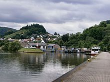
- 4 Mittersheim - The large lake has a surface area of 255 hectares and is also called Lac Vert, which means "Green Lake".

Stage: Sarrebourg to Sarreguemines, approx. 70 km

The two departments Moselle and Bas-Rhin belong to the regions Lorraine and Alsace, which is noticeable in the signs.
 1 Sarrebourg, Moselle - who use the alternative route described above Gondrexange follows, will not get to know Sarrebourg. The place is currently at the end of the Railway cycle pathwho is in Abreschviller begins. Behind the village there is a cycle path to Sarraltroff, then Départmentstraße 43.


- From Sarre-Union one follows the D 23 to Harskirchen and you get to the towpath on the Saar-Kohlen Canal described above, which you follow to Saargemünd (Sarreguemines).
- 3 Harskirchen, Bas-Rhin - Approach of the Saar and the Saar Canal. There is Harskirchen campsite. With a little luck you can see the Saar on the right.

- 4 Sarralbe, Moselle - nice little place with a café, a Lidl (with a butcher shop), a historic town center and also a train station (trains to Saar-Union and Sarreguemines). The Albe river, which accompanies the canal a little to the right, flows into the Saar here. Shortly after the village, the canal side is changed on a cyclist bridge

- 5 Herbitzheim, Bas-Rhin - a bit of "crooked Alsace" with lock 21. The numbering is consecutive to the north (in Germany the other way round)

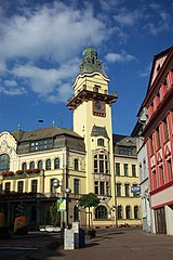
- 6 Sarreguemines, Moselle - on the right bank you can see the historic casino of the faience shop.
_Office_de_Tourisme_Sarreguemines.jpg/323px-Casino_et_Pavillon_2_(c)_Office_de_Tourisme_Sarreguemines.jpg)
Stage: Sarreguemines to Mettlach, 70 km

- 1 Sarreguemines
 2 Saarbrücken, Saarland - At the entrance to the village there is a cyclist bridge that you should use if you want to see the city.

- From Saarbrücken to Völklingen, the cycle path is partly right next to the Saar and below the motorway
 guided. On the other bank of the Saar you can see the industrial facilities of the old steel industry. Those who mainly want to see beautiful scenery can cover this section by train.
- 3 Völklingen - will be bypassed. There isn't even a sign to the city center. Anyone interested in industrial culture should make a detour to Völklinger Hütte plan on.

- 4 Saarlouis - Those who take the alternative through the "Saarlouis City" (there are even 2 signposted options) not only save about 2 km of the Saar loop, but also get to know the large city center.
- 5 Dillingen
- 6 Merzig
- 7 Mettlach


Stage: Mettlach to Konz, 40 km
- 1 Sarreguemines - Alternative routes on both banks from the Serrig lock. Some gravel on the left, loud main road on the right.
 2 Saarburg - the castle on the left side of the mountain, which is better seen from the other bank.
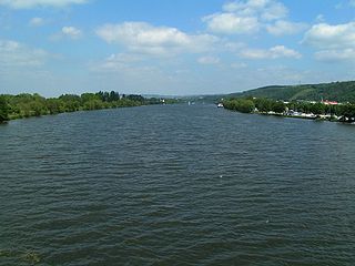
- 3 Conc - Muzzle into the Moselle.

security
It is forbidden to drive on the canal sections at night and that makes sense
connections
References to literature and maps
- bikeline bike tour book, Saar-Radweg: From the French canals to Trier. Esterbauer publishing house, ISBN 3850000060 ; weatherproof / tearproof.
Web links
- www
.vacation - Saarland tourism portal.saarland / Media / Tours / Saarland cycle path - www
.radwanderland - Bike tours in Rhineland-Palatinate.de - www.freizeit-saarmoselle.eu/ - Leisure portal of the Eurodistrict Saar-Moselle