The Schinderhannes cycle path runs on a former railway line from Emmelshausen above Kastellaun to Simmer in the Hunsrück.
Route profile

- Length: 38 km
- Signposting: Yes
- Slopes: 154 m up, 264 m down on the former railway line
- Path condition: the path is paved the entire way
- Traffic load: no
- Suitable bike: 5-speed
- Family suitability: extremely family-friendly
- Inline suitability: The path is paved the whole way and is therefore also well suited for inline skiers.
background
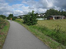
Where trains used to puff, you can now cycle without traffic disruption from Emmelshausen via Kastellaun to Simmern on a former 38 km long railway line in the Hunsrück. The path is paved the whole way. Far away from busy roads, you can cycle with wonderful views of the Hunsrück heights. Forest and field alternate, and every now and then there is a meadow. For the way back you can use the Regional cyclists Unload your bike and relax on the bus.
Is eponymous Johannes Bückler, also known as the Schinderhannes, who gained national notoriety through his enormous criminal activities. On November 21, 1803, the death sentence was carried out.
preparation
getting there
Public transportation
By train
Regional train and regional express Mainz - Koblenz, in Boppard change and to Emmelshausen start up. ´
Bicycle bus
- A leisure bus service with bicycles runs parallel to the route. The "Regio-Radler" travels the route Bingen - Simmern - Kastellaun - Emmelshausen See also: www.regio-radler.de · Cycling experience map 2010 Rhineland-Palatinate-Takt · Timetable 2011, only Sat and Sun 3 trips each
- Bicycle bus Treis cards - Emmelshausen Timetable 2 trips a day
- Bicycle bus Oberwesel - St. Goar - Emmelshausen Timetable, 2 trips a day
By bicycle
- Schinderhannes-Untermosel cycle path of Castles on the Moselle, length: 21.2 km, altitude difference: 122 m up, 510 m down]
Route description with sights
Emmelshausen (464 m above sea level) - Kastellaun: 22.5 km
98 m up, 125 m down
On the first stage from Emmelshausen to Kastellaun, the path leads as a "panorama route" in large loops through the Hunsrück landscape. New perspectives open up again and again.
- Emmelshausen - At the train station, which is served by the Hunsrückbahn, it starts. The place with almost 5000 inhabitants offers refreshment stops and shopping opportunities.
- Pfalzfeld - the former train station offers overnight stays in a sleeping car and a gastronomic offer [1]
- Kastellaun - The small town is dominated by its medieval castle ruins. It once had a 30 meter high keep, which, however, was blown up by French troops with the entire castle during the Palatinate War of Succession in 1689. What remains is the outer wall of the residential tower and some of the hall. In 1999 the first castle house and in 2005 the second castle house were rebuilt. In 2007 a documentation center called the "House of Regional History" was inaugurated there. - See also Wikipedia: Kastellaun Castle
Detour to the Moselle: 30 km
- Hunsrück-Moselle cycle path, Treis-Karden: 30 km, 760 m up, 410 m down.
Kastellaun - Simmern: 14.6 km
56 m up, 140 m down
Behind Kastellaun the landscape changes after leaving the “Kastellauner Mulde” in a slight 1.5 km ascent. From here to Simmern, it goes steadily and gently downhill. About 2 km before Simmern, the illuminated Schmiedel tunnel awaits the cyclist, which with 81 m length is not one of the longest. The high construction makes it uninteresting for bats, which is why it is not closed.
- Simmer - This is located in the district town of the Rhein-Hunsrück district Simmern Castle with a ballroom, the Hunsrück Museum, the Rhein-Hunsrück archive, the history and city library and an exhibition by the painter and sculptor Friedrich Karl Ströher in the attic. The baroque Catholic St. Joseph's Church and the late Gothic Protestant St. Stephen's Church (1486 - 1510) are also worth mentioning. The oldest building is the Schwarzer Adler restaurant (1689). In memory of the Schinderhannes there is the tower named after him in which he was imprisoned.
Other places to stay
security
It goes on from Simmern
By bicycle
- Hunsrück cycle path to the Rhine via Rheinböllen to Niederheimbach bei Bacharach
- Hunsrück cycle path to the Saar
- Hunsrück cycle path and Lützelsoon cycle path to the Nahe via Kirchberg to Kirn
- Rhine-Hunsrück cycle path to the Rhine
- w: Schinderhannes-Soonwald-Radweg, to Gemünden (Simmerbachbrücke), length: 16 km, altitude difference: 180 m, 225 m
- Biebertal circular route near Simmern Pdf, 26.2 km, total meters in altitude: 250 m ascending and descending
By bus
- Regional cyclists to Bingen and Emmelshausen
References to literature and maps
Web links
- Cycling in the Schinderhannes-Land-> Click on the flyer "Cycling in Schinderhannes-Land"