
The Rhine is the longest river flowing into the North Sea at 1236 km. With a navigable length of 844 kilometers, it is one of the most important waterways in Europe. A journey along its banks is very varied. From Rheinfelden (at Basel) the river can be explored by boat to the North Sea. Tips for planning a trip can also be found in the article of Rhine cycle path.
Regions
Partial landscapes
- Source rivers in the Swiss Alps
- Vorderrhein from Lai da Tuma (Lake Toma) at the Oberalp Pass to Ruinaulta (Rhine Gorge)

- Lake Constance - including Untersee, from Fußach to Stone at the Rhein
- Upper Rhine - from Stone at the Rhein to Basel
- Upper Rhine · in the Upper Rhine Plain - from Basel to Bingen
- Middle Rhine · In the Middle Rhine Valley between Taunus / Westerwald / Siebengebirge and Hunsrück / Eifel, · Point of attraction: Loreley
- Lower Rhine · with the Cologne Bay
- Rhine-Maas-Scheldt Delta, also called Rijndelta (Netherlands)
In Millingen on the German-Dutch border, the Lower Rhine divides for the first time into the Nederrijn and the Waal, which takes over 2/3 of the Rhine water. In Arnhem the IJssel branches off and takes over 11% of the Rhine water, 22% remains for the Nederrijn. Further branches and tributaries follow.
The main estuary arms:- Waal, goes into the Merwede, after that about North and Oude Maas in the Nieuwe Maas above. The main part of the Merwerde flows into the southern Nieuwe-Merwede and goes into the Hollands Diep over that is in Haringvliet and Volkerak share, then to the North Sea to end.
- Neder-Rijn, later Lek, this goes into the Nieuwe Maas and then in the Nieuwe Waterweg above. This flows into the North Sea at Hoek van Holland.
- IJssel. It flows into that IJsselmeer.
- There is also an estuary called the Rijn flows into the North Sea at Katwijk. This original arm of the Rhine but has given most of its water to other bodies of water.
Metropolitan areas
Many large cities and metropolitan areas have formed on the Rhine:
- Cross-border Basel region
- Cross-border region Strasbourg
- region Karlsruhe, also as a cross-border region Pamina
- Rhine-Neckar area
- Rhine Main Area
- Rhine-Ruhr conurbation
- region Arnhem/Nijmegen
- Randstad agglomeration (Amsterdam, Rotterdam, The hague, Utrecht)
Neighboring regions
in close proximity to the Rhine
Landscape description
Vorderrhein
The Lai da Tuma, in German Lake Toma, is considered the source of the Vorderrhein and therefore the official birthplace of the Rhine. It is 2345 m high at the foot of Piz Badus in the canton Grisons in the vicinity of the Oberalp Pass not far from the Gotthard massif. A steep path takes the hiker from the Oberalppass (train station) to this basin in just under 2 hours. The meltwater from the snow mountains collects here. A bronze plaque embedded in the rock reads: "Rhine origin 1320 km to the mouth". This long-alleged distance specification is now considered incorrect. It's only around 1233 km. The young river does not enjoy its original wildness everywhere. The power plants in Sedrun and Tavanasa draw the water from tunnels, shafts and reservoirs that were built in the 1960s. In addition to generating electricity, these freed the places from the horrors of the floods with the devastating floods.
The Vorderrheintal is an open landscape, over which a wide sky arches. A road follows below the 2044 m high Oberalp Pass down over Disentis to Ilanz the bed of the fresh Rhine, to then meet the confluence of the Vorderrhein and Hinterrhein in Reichenau near Bonaduz. A mighty landslide about 10,000 years ago slid 12 cubic kilometers of rock material into the valley and covered it over a length of 16 km. Over time, the Rhine washed a channel up to 350 m deep through the debris. The water of the canyon Ruinaulta has dug dark crevasses and yawning caves in the chalk walls. The only traffic route that was built in 1902 was a railway, which is now a romantic experience. You can also experience the gorge on the wild water. The Rhine can be navigated by rubber dinghy or canoe. A footpath also accompanies the Vorderrhein between Ilanz and the Versam-Safien train station. In the direction Chur the path runs above the wild river.

Känzeli is the name of the ledge in the park of Reichenau Castle, where the Vorderrhein and Hinterrhein now converge and flow together as the Alpine Rhine towards Lake Constance.
Medels Rhine
The In there Medel is the longest headwaters of the Rhine. It originates in Italian speaking Ticino as Reno di Medel and flows into the 1908 m high Lai da Sontga Maria reservoir near the Lukmanier Pass. As Rein da Medel, it flows through the Val Medel valley past the Fümatsch waterfall and through the Medelserschlucht gorge (Las Ruinas, also called Hell Gorge) to Disentis in the Vorderrhein.
Vals Rhine
The Valser Rhine flows into the Glogn at Uors, the Ilanz flows into the Vorderrhein.
Hinterrhein
In contrast to the Vorderrhein, which arises from a small mountain lake, the Hinterrhein rises from the Paradise Glacier in the Ticino.
Alpine Rhine
After the confluence of the Vorder and Hinterrhein in Rheichenau above Chur the river is now called the Alpine Rhine.
States / regions / places
Downstream:
 Switzerland
- Ticino, Headwaters of the In there Medel(Italian: Reno di Medel), with the lake Lai da Sontga Maria is the longest headwaters of the Rhine. It ends at Disentis in the Vorderrhein

- Grisons
- Oberalp Pass, Headwaters of the Vorderrhein: Lai da Tuma (Tomasee, 2345 m) between Oberalppass and Val Maighels.
- Disentis
- Ilanz
- Ruinaulta (Rheinschlucht) - It was created after Flimser Rockslide 10,000 years ago.
- Hinterrhein GR - the rises southwest of the municipality Hinterrhein.
- Splügen
- Thusis
- Tamins-Reichenau at Bonaduz: Here the source rivers Hinterrhein and Vorderrhein flow together and form the Alpine Rhine.
- Chur
- St. Gallen (Canton)
- St. Margrethen · On the Alpine Rhine
- Rheineck SG · On the Old Rhine
- Rorschach · at the Bodensee
- Thurgau
- Arbon · at the Bodensee
- Romanshorn · at the Bodensee
- Kreuzlingen · Constance funnel, where the Rhine flows from the Obersee into the Untersee.
- Steckborn
- Schaffhausen (Canton)
- Stone at the Rhein · At the end of the Untersee, the river leaves Lake Constance and flows as Upper Rhine direction Basel
- Schaffhausen
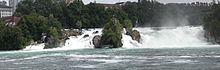
- Neuhausen am Rheinfall - here the Rhine falls 23 meters.
- Zurich (Canton)
- Aargau
- Basel-Country
- Basel city
 Liechtenstein
 Austria
- Vorarlberg
- Fußach at Bregenz
 Germany
- Baden-Wuerttemberg
- Constancy
- Waldshut
- Laufenburg (Baden)
- Bad Säckingen
- Because on the Rhine
- Breisach at the Kaiserstuhl
- Karlsruhe - Castle and fan-shaped city
- Mannheim - Baroque castle and city of squares


- Rhineland-Palatinate
- Germersheim
- Speyer - Imperial Cathedral and Museum of Technology
- Ludwigshafen on the Rhine
- Worms
- Oppenheim
- Mainz · Cathedral, Gutenberg Museum
- 1 The confluence of the Main in the Rhine between Ginsheim-Gustavsburg and Mainz-Kostheim
- Ingelheim · Imperial Palace
- Bingen · Mouse tower
- Bacharach
- St. Goarshausen · Loreley
- Boppard
- Koblenz Deutsches Eck (mouth of the Moselle)
- Neuwied
- And afterwards
- Remagen
- Hesse
- Mainz-Kastel (district of Wiesbaden)
- Wiesbaden Biebrich Castle with castle park, in the city center: Kurhaus, theater, city castle, Kochbrunnen, Neroberg
- Eltville on the Rhine · Electoral castle, old town
- Geisenheim · Johannesburg Castle
- Rudesheim · Niederwald Monument, district of Assmannshausen
- North Rhine-Westphalia
- Bad Honnef
- Bonn
- Cologne - Cologne Cathedral, Roman-Germanic Museum, Chocolate Museum
- Dusseldorf - "Kö" shopping street, Rheinturm
- Duisburg - Landschaftspark Nord and Industrial Heritage Route
- Wesel
- Emmerich on the Rhine

 France
Region: Alsace (French: Alsace)
 Netherlands
- Gelderland
- Utrecht (province)
- Nieuwegein, at the Lek
- Utrecht, on the Oude Rijn
- South Holland
- Overijssel
Other goals
important tributaries
- Aare
- Limmat (flows through Zurich)
- Reuss
- Sihl (largely canalized)
- Ill (ends at Strasbourg)
- Lauter / Wieslauter (reached Wissembourg and Dahn).
- Alb (ends at Karlsruhe)
- Neckar (reached Tubingen, Stuttgart and Heidelberg, ends at Mannheim)
- Main (reached Wurzburg)
- Tiny
- Deaf
- Near (reached Bad Kreuznach)
- Alsenz
- Glan
- Louder (reached Kaiserslautern)
- Lahn, cf. Lahn valley
- dill
- Moselle, cf. Moselle valley
- Readers
- Ruwer
- Kyll, cf. Kylltal
- Saar
- Blew (reached Zweibrücken)
- Angry
- Our
- Alzette (reached Luxembourg city)
- Ahr, cf. Ahr Valley
- victory
- Wupper
- Erft
- Dysentery
- lip
- Issel (flows into the Dutch IJssel)
further river landscapes
closely related to the Rhine
other neighboring waters
background
language
The Rhine reaches the following language areas:
- Italian
- Romansh
- German
- French
- Dutch
getting there
mobility
The Rhine is largely navigable and is also accompanied on both sides by all kinds of transport axes:
- Railway lines
- Motorways, federal highways and their counterparts in neighboring states
- Bike paths
By train
- The train ride from Chur to Rotterdam takes over 10 hours, with a change in Zurich or Basel and Utrecht
- Within Switzerland, from Domat via Chur to Basel it takes about 2 3/4 hours by train.
- For the German section, for example Basel to Emmerich on the Rhine it takes more than 6 hours, with a change in Mannheim and Dusseldorf.
- For the French section of Basel to Lauterbourg above Strasbourg you have to calculate at least 2 1/2 hours.
- Netherlands: From Arnhem to Suffer above Utrecht you drive 1 3/4 hours
By bicycle
The Rhine is for the most part on both sides of the Rhine cycle route accompanied.
shipping
Most of the Rhine is navigable below Lake Constance. From the mouth of the Rhine to Birsfelden above Basel, it is a very important waterway for freight traffic. The Rhine can also be navigated by pleasure boats. The conditions above Lake Constance need to be clarified. The Rhine in the area of the waterfall near Schaffhausen is definitely not navigable.
For sailors, the Rhine is primarily a part of the connection to the Black Sea. In addition, there are many quarry ponds in the Upper Rhine Plain and in the Lower Rhine in the immediate vicinity of the river and old parts of the river, which are often still connected to the river. As long as they are deep enough and lounging is allowed, they are excellent berths for one night, and marinas are often to be found there, as in former raft harbors.
The clearance height of the bridges should be 9 m above sea level in front of Kehl, so at "normal" water levels, smaller yachts should be able to sail with a standing mast.
The many groynes easily tempt you to use the countercurrent in the Kribben when driving up the mountain. Attention! In the extremely low water of 2003, it became clear that there was dangerous junk in parts of one in three cribs!
Upper Rhine
The Upper Rhine is not navigable near Schaffhausen because of the Rhine Falls. Otherwise it can be used by passenger shipping, the individual barrages are equipped with locks. However, the individual operators only drive parts of the route and not the entire Upper Rhine.
Public passenger shipping (Status: 2007 timetable):
- Kreuzlingen-Stone at the Rhein-Schaffhausen, Course book number 3820, July 7th-September 9th, 4 journeys per day in each direction
- Rhine Falls Schlössli Wörth-Rheinau power plant, Kursbuchnummer 3761, Sun † April 1 - October 14, daily July 9 - August 24, up to 8 journeys in each direction.
- Rhine Falls Schlössli Wörth-Eglisau, Course book number 3760, only Sundays and public holidays May 6th-30th. September and May 1st, 1 journey requiring reservation in each direction
- Rheinfelden-Augst-Basel, Course book number 3700, April 6th - October 14th, irregular Wed-Sun (please note traffic restrictions) 2 journeys in each direction.
- Various tours from Basel, course book number 3701-3705, May-mid-October
Middle Rhine
- see inter alia Cologne-Düsseldorfer
Air travel
- There is a direct flight connection between, for example Zurich and Amsterdam, with a flight time of about 1 1/2 hours
Tourist Attractions
- Vorderrheinquelle Search for "Tomasee" / "Vier-Quellen-Weg"
- Rhine Gorge
- Lake Constance
- The Rhine Falls near Schaffhausen
- Kühkopf-Knoblochsaue nature reserve - The area is about 30 km south of Frankfurt and is the largest preserved floodplain area of the Upper Rhine.
- Rheingau
- Middle Rhine Valley - rugged valley with the Loreley, numerous castles and cozy towns and villages
activities
- Cycling on the Rhine cycle route
- Water sports on the river, Lake Constance, the arms of the Old Rhine, in the area of the estuary delta
Regular events
- At Rhine in Flames are fireworks that take place on different days on different sections of the Middle Rhine. Passenger ships sail across the river to offer their guests the fireworks that are started when the ships arrive. Wine and folk festivals are held on the banks on the appropriate dates.
- between Linz on the Rhine and Bonn on the 1st Saturday in May
- between Niederheimbach and Bingen/Rudesheim 1st Saturday in July
- between Spay and Koblenz on the 2nd Saturday in August
- in Oberwesel on the 2nd Saturday in September
- between Sankt Goar and Sankt Goarshausen on the 3rd Saturday of September
kitchen
- As the Rhine reaches various European cultural areas, cooking habits will change.
- In general, people near the Rhine are prepared to entertain travelers. At the usual times of the day, sometimes around the clock on the motorways, a good selection of dishes is offered.
nightlife
security
climate
In the area between the Rhine valley at Liechtenstein to Cologne Bay the climate is consistently warmer and lower in precipitation than in the respective neighboring regions. However, inversion weather conditions, fog, thunderstorms on the Rhine are somewhat more likely than away from the lowlands of the Rhine.