
The Kylltal cycle path runs in the Eifel and leads from Losheim above Gerolstein to trier. It is characterized by an almost continuous accompaniment by the regional train.

Route profile
- Length: 123 km
- Signposting:: conforming to standards with your own logo
- Slopes: Moderate inclines in both directions. There is a steep incline between Kyllburg and Erdorf, for this section of 6.4 km with 120 or 150 m ascent, the train is recommended. Total difference in altitude: 640 m up, 1,180 m down.
- Path condition: the high proportion of country roads leads to a high proportion of asphalt roads, only very short unpaved sections
- Traffic load: high proportion of public roads, mostly little traffic
- Suitable bike: Touring bike with 7 gears
- Family suitability: Suitable for families with school children, a children's bike path has been set up between Bewingen and Densborn
- Inline suitability: very suitable between Losheim and Jünkerath, suitable in the Birresborn area.
background
- The Kyll is a left tributary of the Moselle and at the same time the longest and richest river in the Eifel (10 m³ / s, 142 km). It forms in the Zitterwald from four (?) Underground source streams near Losheimergraben on the German-Belgian border (at the roundabout). She sees the light of day south of Scheiden. At Ehrang it flows into the Moselle. The valley is often narrow and hardly allows the construction of a cycle path. The thin settlement makes it possible to use local roads. The lack of motorways and federal roads in the valley makes for a quiet natural pleasure.
- In two places the cycle path leads through tunnels, in place of the second disused track of an active railway line. One tunnel is between St. Thomas and Kyllburg, the second north of Daufenbach. In total, an estimated 30 km of former railway lines are being used.
- An important one led from Trier to Cologne 2000 years ago Roman road through the Eifel parallel to the Kyll. However, the Romans preferred the slopes and not the deep valley, which was probably quite wild at the time. Nevertheless, the remains of this submerged high culture can be found in some places.
- The children's cycle path between Bewingen and Densborn is by no means specially protected or set up. It partly runs on public roads. The playgrounds are interesting for the children, although they are hardly associated with a bike tour. The section of the railway line from Losheim to Jünkerath is more suitable for small children.
preparation
getting there
Public transportation
Hellenthal-Losheim
Trier-Honor
- Ehrang train station
- Ehrang junction station
- Trier main station with IC connection 10 km away
More entry points
- Many DB stops between Jünkerath and Honor (Cologne-Trier line, DB regional transport).

In the street
- Hellenthal-Losheim is looking good Aachen and trier reachable. Winter tires are required in the cold season.
- trier is good from the directions Luxembourg city, Koblenz and Saarbrücken reachable (A64, A 602)
By bicycle
Hellenthal-Losheim
- of the Vennbahn via the Vennquerbahn cycle path (RAVeL line 45A)
- for the journey out Heimbach, the end point of the Rurtalbahn, you should plan a day (60 km).
trier-Honor
- Moselle cycle path, 3 days off Metz, 3 days off Koblenz
- Saar cycle path, 2 days off Saarbrücken
- Sauerradweg, one day off Water cheap
Route description with sights

Hellenthal-Losheim − Jünkerath, approx. 19 km
This section now runs on the route of the former Vennquerbahn. The new cycle path shines with a fine asphalt surface and is almost flat. The time saved compared to the old route can be used for a swim in Lake Kronenburger See. Or for a visit to the Bütgenbacher See in Belgium.
- Losheim - Belgian border, line 45A of the RAVeL network continues in Germany. The Kyllquelle is located northwest in Losheimergraben. We are in North Rhine-Westphalia for a short time, but Rhineland-Palatinate is not far. The federal states change here more often, which is clear from the road markings. Cooperation between the federal states seems to have worked well during construction. The bridge over the state border allows a descent to the bike path.
- Hergersberg (B) - With Ardennes border market (Shopping and gastronomy). The cycle path does not cross the Belgian border.

- Echo - behind the village is the Kyll reservoir Kronenburger Seethat you can see well from the high route. Bathing is possible.
- Stadtkyll - the small place (1500 Ew.) is not really a city, but has a gastronomic offer not far from the bike path. It's a few meters away, but you can get to know the Kyll up close.
- → Connection to the Prümtal cycle path
- Jünkerath - big old train station that is passed. Bike route on local roads. Remains of the Roman settlement are worth seeing Icorigium. The railway museum provides information about the eventful history of the Vennquerbahn.[1]
Jünkerath − Kyllburg, approx. 49 km
The train runs right next to the Kyll and behind the train there is a cycle path. This can be a farm road, but the route is often reserved for cyclists by means of blue signs. Cyclists therefore don't see the river that often. This section has only short climbs and is mostly flat.
- Jünkerath
- Gönnersdorf - Distance from the river on local roads
- Lissendorf - Railway station.
- → Oberbettingen - The settlement at the train station is approx. 4 km from the main town Hillesheim away
- Bolsdorf - eponymous for the idyllic Bolsdorf valley. The village is steep and winding downhill.
- → Connection to the Kalkeifel cycle path with connection to the Ahr. After Hillesheim it goes uphill again. If you are in a hurry and / or want to save altitude, it is better to cycle from (east) Oberbettingen towards Hillesheim.
- Dohm - It goes steeply down through the village, the Remigius Chapel is on the right on a hill.
- Bewing - District of Gerolstein
- Pelm - It's worth seeing Kasselburg and her 37 meter high twin tower on the right. You can best see them on the bridge to Pelm, if you don't want to cycle up the mountain to the right.
- main place Gerolstein, Cyclist bus to Cochem on the Moselle
- Lissingen - The Double castle Lissingen was never destroyed and is therefore quite well preserved. It is privately owned, which also pursues tourist interests. However, our cycle route remains on the left bank, so that interested parties have to branch off. The Kyll is then crossed together with the train, the cycle path soon following Landesstraße 24. On the right we see the red pavilion of the Linden springwhose water is just as drinkable as the well-known "Gerolsteiner" (mineral water).
- → Connection to the Eifel-Ardennes cycle path to Prüm with the possibility of visiting the castle (currently closed due to renovation). Next door there is also a monastery in better condition.
- Birresborn - Railway station

- Mürlenbach - Bertradaburg on the right, DB stop
- Densborn, DB stop
- Usch, DB stop
- Saint Thomas - the place owes its name to the former monastery of St. Thomas, which also lines the cycle path (the narrow main street). Look out for the impressive gardens. DB stop almost opposite the monastery. Then a bridge over the Kyll and the route is now on the left.
- Kyllburgweiler - about here use of a train tunnel
- Kyllburg - Railway station. Place is a bit bigger and offers refreshment stops.
Kyllburg − Trier-Honor: 45 km
The Kyll is getting wider, but the valley is not, so that there is even less space for a bike path. The regional train runs through numerous tunnels and impresses with its pretty stations. The valley is woody and green and the villages are small. The "mountain test" right at the beginning (country road with extreme gradients) can be bypassed by train (Kyllburg - Erdorf).
- Kyllburg - Behind the village there is a steep pass road with a 13% incline, which is largely avoided by regular road traffic due to its poor development. The route is winding and narrow, so that there are problems with oncoming traffic. There is a resting place on the hill that could be described as a meeting place for cyclists. Around here the narrow street meets a somewhat wider one with more traffic and it goes down again. The high-altitude tour shortens a larger loop of the river without a developed traffic route.
- Detour → Malberg - the historic town center and the baroque Malberg Castle are listed as a monument zone (castle on top of a hill)
- Detour → Flowem – Roman villa Otrang on the Roman military road from Trier to Cologne.
- Wilsecker behind the top of the pass, but still a country road
- Bitburg-Earth village, imposing train station, behind the somewhat larger town there is a somewhat hilly route on farm roads above the Kyll.
- → Connection to the Nims-Kyll cycle path, which is west of Bitburg at the Nimstal cycle path ends. Partly railway cycle path and also suitable to visit the beer city.

- Hüttingen on the Kyll, Train station, from here on the bike path is quite good and also flat (railway cycle path?)
- → Gondorf - Eifelpark (zoo)
- Phillipsheim - Former Hofgut Pfalzkyll of Himmerod Abbey, train station
- → junction "Bähnchentrasse" to Binsfeld, a railway cycle path with a steady rise through partly dense forest, continuation to Maare-Moselle cycle path planned, there are still 22 km after Wittlich
- Storage - Railway station
- Auw on the Kyll - nice old train station. Approximately from here the railway line of the disused second track is used. The second tunnel passage also takes place in this context.
- Daufenbach - Railway station
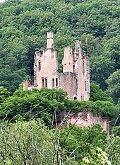
- cord- enthroned here Ramstein Castle idyllically high on a rock. DB stop
- Trier-Honor - Suburb with 2 train stations.
- → Connection to Moselle cycle path.
Trier-Honor – trier: 11 km
It is another 11 km to Trier main station.
- Pfalzel - If you want to use the Ehrang train station in Pfalzel, turn right at the entrance to the village. The small district of Pfalzel is the neighbor of the larger Ehrang. We follow the Kyll a little longer and then drive along the left bank of the Moselle until we cross a bridge. Then continue on the right bank of the Moselle in the opposite direction, where the signs are lost. Follow the signs for the Moselle cycle path (Trier train station detour), past the Porta Nigra, to
- trier Main station - The trains from Cologne-Deutz arrive at track 10 North, which then follow the Kyll again.
Other places to stay
security
connections
In Hellenthal
- Connection to the Vennbahn via the "Vennquerbahn-Radweg" (name unofficially, cycle route W8 in Wallonia). The crossing is in Weywertz.
In trier
- Transition to Moselle cycle path to Lorraine and after Koblenz
- Continuation of the 5 valleys route above Water cheap, Minden an der Sauer to Bitburg-Erdorf (circuit)
- Transition to Saar cycle path - Junction in Konz west of Trier