The Eifel is a region in western Germany, which is used in both Rhineland-Palatinate as well as in North Rhine-Westphalia lies. Small parts are in Belgium.
background
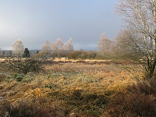
The low mountain range is part of the Rhenish Slate Mountains. The parts that continue to the west belong to the Ardennes. The Eifel is divided into numerous mountains and valleys, which are less pronounced than in other low mountain ranges, but more extensive. It does not manage to hide its partly volcanic history - even if the volcanic chimneys have now become lakes and the volcanic cones are covered by forest.
Season times
You can travel to the Eifel all year round. It should be noted:
- The main season is between Easter and autumn.
- The winter sports resorts (Schneifel, Hohe Acht) are often inadequately prepared for unexpected and early snow phases.
- The Christmas market in Monschau enjoys great popularity. Parking spaces are scarce at this time, even in bad weather.
- The events (motorsport, Rock am Ring etc.) on Nürburgring are a top event that causes heavy traffic and crowds in the vicinity of the ring on the feeder roads. If you are not coming for the event, you should avoid this area at this time. The environment includes, for example, that Ahr Valley.
Regions
- Rureifel.

 in the Wikidata database") The Rur shapes this part of the Eifel, with its own valley and the valleys of its tributaries and streams. With Rursee, upper Rurtal, Schleiden Valley, Eifel National Park.
The Rur shapes this part of the Eifel, with its own valley and the valleys of its tributaries and streams. With Rursee, upper Rurtal, Schleiden Valley, Eifel National Park. - Ahr Valley.
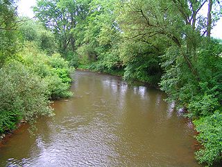
 characterized by viticulture on the southern slopes and the picturesque rocky landscape that the river created when it cut into the Ahr mountains around 300 meters deep.
 - Vulkaneifel
 (Vulkaneifel district). with the Eastern Eifel with the Laacher See, Hocheifel near Adenau, with the "Hohen Acht", Maifeld around Mayen, Transition to Middle Rhine Valley, Moseleifel, transition to Moselle valley, Western Vulkaneifel near Daun.


places

.jpg/267px-Heimbach,_G^M_2013_-_panoramio_(2).jpg)
.jpg/300px-52156_Monschau,_Germany_-_panoramio_(35).jpg)
.jpg/300px-52156_Monschau,_Germany_-_panoramio_(39).jpg)


- 7 Bad Neuenahr-Ahrweiler. District town with the historic old town (Ahrweiler), baths and casino (Bad Neuenahr) and the most important town in the Ahr Valley.


.jpg/350px-Dernau(gwz).jpg)


Other goals
Nature parks
Several nature parks and the Eifel National Park form a coherent area.
- 1 Hohes Venn-Eifel Nature Park (Nature Park Hoge Venen-Eifel)
- 2 German-Luxembourg nature park (South Eifel Nature Park)
- 3 Vulkaneifel Nature Park

landscape
- 4 Rurtal.river landscapes worth seeing.
- 5 Ahr Valley.River landscapes worth seeing are characterized by viticulture on the southern slopes and the picturesque rocky landscape.
- 6 Kylltal.river landscapes worth seeing.
- 7 Devil's Gorge.Impressive rock landscape with narrow gorges, deep crevices, steep walls and bizarre rock formations.
- 9 Birresborn ice caves..Since the air in the cave does not circulate and is cooled by the surrounding rock, ice is created, which exists regardless of the season. They are not of natural origin. For a long time, millstones were extracted in the region by underground mining. As a result, three tunnels remained here that can be visited. In the past, the caves were also used as refrigerators.


Lakes
- 11 Laacher See.largest lake of volcanic origin (Calderasee) in the Eifel and largest lake in Rhineland-Palatinate. From the Lydia tower you have a beautiful view of the crater lake. The 23 m high, freely accessible tower is at 50 ° 25 '37 "N.7 ° 16 ′ 21 ″ E to find. On the lake there is also the beautiful, well-visited Maria Laach Abbey.


Mountains and viewpoints
- 1 High eight.with 747 m highest elevation of the mountains; beautiful panoramic view from the Kaiser Wilhelm Tower; Winter sports possibilities (ski lift, toboggan run, cross-country trails).
- 2 Black man.692 m, with winter sports facilities.
- 3 White stone (White stone).689 m, with winter sports facilities.
- 5 Dietzenley.On the mostly wooded hilltop there is a small, wooden observation tower that offers a good view of the Vulkaneifel. Slightly below there is a converter and the remains of a Celtic ring wall. From Gerolstein, Pelm and Gees, the Dietzenley can be reached on hiking trails.


Monasteries

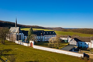


- 1 Maria Laach Abbey (Abdij Maria Laach). The abbey is a monastery that belongs to the Beuron Congregation of the Benedictine Order. It was built between 1093 and 1216. It is considered to be one of the most beautiful monuments of Romanesque architecture from the Salier period in Germany.
- 3 Himmerod Abbey (Abdij van Himmerod).A Cistercian abbey founded in 1134. After the Second World War, the abbey gained general fame in 1950 through the Himmeroder memorandum, which was the cornerstone of the rearmament of the Federal Republic. The Himmerod Abbey was part of the Mehrerau Congregation, which resolved to dissolve the monastery in October 2017.
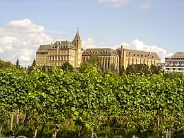
- 4 Steinfeld Monastery (Klooster Steinfeld).Former Premonstratensian abbey with an important basilica from the early 12th century. The monastery complex has been owned by the Salvatorian Order since 1923.
- 5 Kalvarienberg Monastery.It was a monastery run by the Ursulines, to which a Way of the Cross with 14 stations leads up. The convent, founded in 1838, was closed in 2017 for reasons of age, a lack of young talent and due to its poor economic situation.
- 6 Reichenstein Monastery.The monastery has been a Benedictine monastery since 2017. In the 12th century there was a Premonstratensian monastery on the site of a hilltop castle from the 11th century. After the dissolution as a result of the French secularization, the Reichenstein estate came into private hands. In 2008, the French Abbey of Notre-Dame de Bellaigue, which was related to the Apostate Brotherhood of St. Pius X., acquired the building in order to establish a Benedictine monastery there.


Castles and Palaces


- 1 Kühlseggen Castle.romantic moated castle, which, however, cannot be visited from the inside.
- 2 Nideggen Castle (Burcht Nideggen).With castle museum. Events, concerts and festivals take place here regularly.
- 3 Wildenburg Castle.It is a popular destination with a hotel and restaurant, particularly popular with hikers and cyclists.
- 4 Kerpen Castle.above the place of the same name. The facility is used as a school camp. The exterior of the castle and the chapel can still be visited.
- 5 Kasselburg (Adler and Wolfspark Kasselburg).The facility is located in Adler and Wolfspark Kasselburg at Gerolstein and can be visited (tower ascent is possible).
- 6 Lissingen Castle (Lissingen Castle)
- 7 Bertradaburg.The castle was built on the remains of a Roman fort, which presumably served to protect the Roman road from Trier to Cologne. According to local tradition, Bertrada, the mother of Charlemagne, lived in the castle, which suggests that he was born around 747. Today it is privately owned.


- 10 Eltz Castle. It is one of the most famous and at the same time one of the most beautiful castles in Germany.

- 11 Bürresheim Castle (Slot Bürresheim).Bürresheim Castle has never been conquered or destroyed since it was built in the 12th century. Original furniture transports visitors back to the Middle Ages.


Museums
Museums of national importance:
- 13 Eifel volcano museum Daun (Daun volcano museum).In addition to many information boards, photos and exhibits from the Vulkaneifel, but also from currently active volcanoes from Europe and Asia, provide insights into the geological development of the Vulkaneifel.
- 14 Maarmuseum Manderscheid.Exhibition on the formation, history and development of the Eifel maars in the past and present.
- 15 Strohn volcano house.The museum has accessible experience rooms, information boards and explanatory graphics.
- 16 Eifel bell foundry.in Brockscheid Down - The company can be visited as part of a half-hour tour (groups only by prior arrangement).
- 17 Ars Tecnica. near Losheim on the German-Belgian border. You can see, among others. a large model railway exhibition with a scale of 1:87, Europe's largest nativity scene collection and a doll collection.


- 18 Mechernich Mining Museum.Tools, photos, etc. from lead ore construction are shown here. The visitor mine, which opened in 1995, can also be visited.

- 19 LVR open-air museum in Kommern.
 With over 100 hectares, it is one of the largest open-air museums in Europe with around 75 historical buildings from the Prussian Rhine Province.
.jpg/350px-Freilichtmuseum_Kommern_-_Haus_aus_Rhinschenschmidthausen,_Bergisches_Land_(12903341704).jpg)
Wildlife parks, game reserves and amusement parks
- 2 Daun wildlife and adventure park (Deer and Saupark Daun).With 220 hectares, this is a very spacious facility near Daun.
- 3 Hellenthal game reserve.is open all year round at least 10 a.m. to 5 p.m. Flight demonstrations of the griffin station in the game reserve also take place daily.
- 6 Barefoot and Generation Park Schmidtheim

Motorsport


getting there
By plane
- Airports for scheduled air traffic are among others at Cologne (Cologne Bonn Airport), Rooster (Hahn / Hunsrück Airport), Luxembourg, Liege (Belgium) (Liège Airport) and Frankfurt (Frankfurt Airport).
- In the Eifel there are also some airfields for self-pilots, for example in Bitburg, Dahlem, Bad Neuenahr-Ahrweiler
By train
- The most important railway line for regional traffic is running out Cologne above Gerolstein to trier, across the Eifel.
- Other cities are connected to the nationwide rail network by regional lines. Among other things, many parishes are in the Ahr Valley (DB), in Rurtal (Rurtalbahn), as well as Mayen Accessible daily by rail.
Bus transport
- The bus network is very patchy in many rural areas; it is a little cheaper in the Ahr Valley as well as in the Liesertal (Daun to Wittlich and further towards Bernkastel-Kues) and around the centers. With a little patience, however, many places can be reached. Some bus companies are also set up to take bicycles with them.
In the street
- The A1 Saarbrücken - Moselle valley - Down (provisional end north of Daun, gap closure to Blankenheim planned) respectively Cologne - Euskirchen - Blankenheim (Ahr)
- The A 48 Koblenz - Vulkaneifel triangle runs on the southern edge of the Eifel parallel to the Moselle valley.
- The A 61 Mönchengladbach - Koblenz runs in the east of the Eifel.
- In Belgium there is a motorway (E 42 / A 27) from Verviers to Lead alf on the western edge of the Eifel; it continues up in Germany Wittlich away (A 60).
- The eastern Eifel with the Ahr valley can be reached via the B 9 (Bonn-Koblenz), which has been developed as an expressway.
By bicycle
Bicycles can be taken on public transport
- Bicycles can usually be taken on the railways and are free of charge. The rail network is patchy and often poorly linked, but most areas of the Eifel can be reached in a few hours by bike (up to 30 km) from the train stops.
- Some bus routes offer bicycles for a surcharge of € 3, e.g. Regioradler Vulkaneifel: Gerolstein - Daun or Regioradler MaareMosel: Bernkastel-Kues - Daun . Registration for bicycle transport is recommended; it costs an additional fee of EUR 1.50 per 5 bikes for the "Regio-Radler". It is not possible to take bicycles on Luxembourg buses.
- Excursion boats on the Rhine, Moselle and the lakes (e.g. Rursee) usually offer bicycle transport.
Arrival by bike on long-distance cycle routes
River valleys make cycling tours through the Eifel easier. The following are possible here:
- The Rur with the tributaries Urft and Olef reaches the high altitudes of the High Fens, the Schnee-Eifel and the Rureifel. She leaves at Kreuzau the area of the Eifel and flows into Roermond in the Meuse.
- If you are the Erft against the direction of flow, you also reach the Kalkeifel. The Kermeter can be reached via tributaries of the Erft. She leaves in the urban area Euskirchen the area of the Eifel and flows into Neuss in the Rhine.
- On the Ahr cycle path and the tributaries of the Ahr, you can reach the Kalkeifel and the Hocheifel on a gentle climb. The Ahr leaves in Sinzig the area of the Eifel and flows into the Rhine at Sinzig.
- The Kylltal cycle path begins at the Belgian border on the northern foothills of the Schneifel and opens up the western Eifel. The Kyll flows into Trier-Honor in the Moselle.
- The Angry with the tributaries Prüm, Nims, Our, the ascent to the Schneifel, the High Fens, the West Eifel and the Ösling (central north Luxembourg) is easier. The Sauer flows at Water cheap in the Moselle.
mobility
- The mobility between the sub-regions of the Eifel is due to the poor connection between the various Rail and bus networks as well as being made more difficult by different timetables on working days, weekends and seasons.
- Who with the bicycle is on the move, can bridge the gaps between the networks with his vehicle. A further expansion of the cycle paths is planned. Not only the railways, but also many bus companies offer bicycles.
activities
hike
Long-distance hiking trails in and through the mountains:
- Readers' path Daun-Wittlich 42 km, 2 days
- Eifelsteig Aachen-Trier 313 km, divided into 15 stages
- Red wine hiking trail above the Ahr
Hiking clubs:
- Eifelverein e.V. based in Düren
- Cologne Eifelverein e.V. based in Cologne, but marks more trails on the right bank of the Rhine
Cycling
General information
- The Eifel has a well-developed network of cycle routes. A route overview to the North Eifel is in the article Cycle routes in North Rhine-Westphalia to find. The routes in the Rhineland-Palatinate part of the mountains are at the Cycle routes in Rhineland-Palatinate.
- In general, the Eifel is sparsely populated and is not burdened with transit traffic. Therefore there are relatively large, quiet areas in the Eifel.
- Long-distance bike tours away from the few railway lines require a certain amount of discipline on the part of the tour participants, because in many cases it is not easily possible to prematurely break off a journey. However, there are some attractive routes in the Eifel in the immediate vicinity of railway lines.
- Inclines can also be expected on river routes. Away from the river routes, steep or longer inclines can also be expected.
Some interesting routes
- Ahr cycle path - on the Rhine and to the west
- RurUfer cycle path - Northern edge with national park
- Kylltal cycle path - From north to south through the low mountain range
- Eifel-Ardennes cycle path - From east to west or vice versa
- Maare-Moselle cycle path - discover the world of the maars
- Maifeld cycle path - maybe it will one day be extended to the Rhine
- Eifelhöhenroute - a 230 km long, demanding round trip from mountain to mountain
Draisines
- Rail biking in the High Fens - Draisine route with bicycle draisines Monschau-Kalterherberg to Sourbrodt (journey time about 45 minutes). Further information: www.railbike.be
Water sports / swimming
- Water sports are possible on the Rursee and other lakes.
- On some sections of the Rur and Sauer rivers, canoeing is possible, sometimes only with restrictions.
- There are swimming opportunities, for example, at Freilinger See near Blankenheim and at Rursee. Some maars / caldera lakes are also open for swimming.
Winter sports
Usually, at least in the high elevations of the Eifel above 600 m, you will find acceptable snow conditions for tobogganing and skiing for a few weeks in the winter season. However, it cannot always be assumed that existing lifts will also be in operation, especially when winter sets in early or unexpectedly.
Alpine skiing
There are winter sports areas with lifts in the area of the Schneifel and the Hocheifel.
- Winter sports area Hohe Acht - there are also trails.
- Winter sports areas "Schwarzer Mann" and "Wolfsschlucht" near Prüm in the Schneifel. The Schwarzer Mann ski area has 2 lifts with a total of 1500 m of slopes; there are further lifts in the area of Hellenthal-Hollerath, including Weißer Stein.
Nordic skiing
- Eifel ski center - is located near Rocherath in the German-speaking Belgian part of the mountains at 650 m. There are about 25 km of trails from easy to difficult. Ski rental: € 8 per day including trail fee (as of 02-2010, info).
- Also in Eifel National Park some routes are approved for cross-country skiing.
Christmas markets
in selection:
carnival
- Ghost parade on Carnival Saturday in Blankenheim (Ahr)
Pilgrimages
The Eifel is an important pilgrimage region. Many pilgrimage destinations are in the Eifel or in neighboring cities.
- Matthias pilgrimage is among other things as a foot pilgrimage of Aachen to trier carried out.
- trier and Aachen are also independent goals of pilgrimages. On Aachen see also Kornelimünster.
- Heimbacher Pilgrimage, see also Mariawald Abbey
- Steinfeld houses the relics of St. Hermann Joseph von Steinfeld
- Brother Klaus Chapel Mechernich-Wachendorf (Nikolaus von der Flüe)
- Place of pilgrimage Klausen with motorcycle pilgrimage not far from Wittlich.
Sport (passive)
- Motorsport - on the Nürburgring
kitchen
- Eifel dumplings are cams made of flour, eggs, milk, water and salt. You used to have a meatless meal on Friday. As a side dish there are strawberries, wild berries or plums, but also pesto or fried bacon.
In the Eifel there is the usual density of restaurants and other catering establishments in Germany. There are also attractive restaurants at many excursion destinations. In the following, companies with nationwide awareness are listed:
- Monastery restaurant the Mariawald Abbey is known for the "Mariawald pea soup". There you can also buy liqueurs and other specialties.
- Simonbräu brewery bar in Bitburg; Reservation is recommended
- Heino's Rathaus-Café in Bad Münstereifel
- Förster's wine terraces in Walporzheim above the Ahr on the red wine hiking trail
nightlife
security
Road traffic hazards:
- In the entire Eifel is with Deer crossing to be expected, partly also within the localities. This danger is not always adequately pointed out, not even by appropriate speed limits.
- The temperatures within the Eifel can fluctuate by more than 5 degrees over a short distance, also contrary to expectations (lower-lying places can be colder). The weather-related road conditions can therefore change, especially in the transitional periods. When traveling in the cold season (November to April) it is Winter tires required.
- Often times are motorcycles involved in serious accidents. It is possible that curves (curve radii, oncoming traffic, road surface, obstacles) are assessed incorrectly. Of course, cars and cyclists are also at risk on sloping, winding roads.
climate
- In the middle, it is often around 4 degrees colder than in Cologne. However, significant temperature fluctuations between the sub-regions and altitudes of the Eifel are to be expected. Snow-free winters are rare; in the high areas it is often enough to toboggan even if nothing of the snow can be seen in the valleys.
- These are, for example, preferred locations within the Eifel Ahr Valley, the lower Sauertal (viticulture is possible here), the middle one Rurtal below the Rursee.
- The temperatures are very different: summer / day: 32 ° Celsius (maximum), at night: 15 ° Celsius (minimum), winter / day: -2 ° Celsius (maximum), at night: -6 ° Celsius (minimal).
trips
- In the Gutland:
- In Limburg (Netherlands)
- Liege
- Cologne Bay
- Moselle valley
literature
- D'hein: Nature and culture guide Vulkanland Eifel. With 26 stations on the "German Volcano Road". Gaasterland Verlag, Düsseldorf 2006. ISBN 3-935873-15-8
- Andreas Stieglitz, Ingrid Retterath: Polyglot on tour: Eifel, Munich 2006, ISBN 3-493-566298
- Ingrid Retterath: Eifel with children, pmv Frankfurt 2004, ISBN 3-89859-408-4
- Helmut Dumler: Hiking with children - Eifel, Bruckmann 2003, ISBN 3-7654-3993-2
- Matthias Zender: Legends and stories from the West Eifel. Bonn 1934 (3rd edition 1980)
Cycling literature
- Rivers and railway lines Eifel: Ahr, Enz, Erft, Kalkeifel, Kyll, Maare-Mosel, Prüm, Urft, Vennbahn - 722 km (Bikeline bike tour books). Esterbauer, ISBN 978-3850006828 . - 2016
- Bikeline guide "Radatlas Eifel" 1: 75000 - see Esterbauer publishing house
- ADFC regional map "Eifel / Mosel" 1: 75000 ISBN 978-3-87073-561-6 please refer Bielefelder Verlag
Web links
- Eifel tourism (Seat in Prüm)
- National park side