
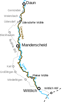
The Readers' path is a popular hiking trail of the Eifel. It runs over 42 km from Down above Manderscheid to Wittlich along the river Lieser.
background

The Lieserpfad is part of the Erft-Lieser-Mosel-Weg (Hauptwanderweg 3) of the Eifelverein and is quite well marked by signs with a blue L on a green square. The Lieserpfad became particularly well-known through the book You have to hike. Without a stick and hat in the German low mountain range of the author, comedian and hobby hiker Manuel Andrack (see literature). He describes the Lieserpfad as somewhat exaggerated "The most beautiful hiking trail in the world".
preparation
The Eifel town is recommended for an overnight stay Manderscheid, which is the stage of the Lieser path. A room in one of the Hotels or boarding houses should be reserved in advance, as these could be fully booked, especially on popular summer weekends
getting there
Wittlich is on the Moselle route and can be easily reached by train (note that the Wittlich train station is 3 km from the city center in the Wengerohr suburb). The journey to Down using public transport is a bit more cumbersome. The regular bus connection from Cochem or from Wittlich. For the hike along the Lieser Path, bus line 300 from Down above Manderscheid to Wittlich Interesting: Even if the line does not run directly through the Liesertal, it roughly follows the course of the river above the valley (see map). The stops in Gemünden, Weiersbach and Üdersdorf (first stage) and Karl, Großlittgen and Minderlittgen (second stage) offer opportunities to shorten the hike.
hike

Upper Lieser Path: Down - Manderscheid (approx. 18 km)
Of Down the hike begins with a route through the beautiful Dauner Kurpark to Gemündener Maar with its natural swimming pool. We continue above the Lieser, past Gemünden and Weiersbach. After approx. 8 km you will reach the Üdersdorfer mill. This is an ideal place to stop off and enjoy the home-style cuisine, as there is no further opportunity for food for the next 10 km to Manderscheid. From Üdersdorf the path first leads along meadows through which the Lieser meanders, and finally goes uphill again up the slope. Halfway up, follow the course of the Lieser and pass the Eckfelder Trockenmaar, which is only 200 m away from the hiking trail. The last section of the first stage leads on winding paths through picturesque forests until you finally reach the Eifel town with a view of the Manderscheider Oberburg Manderscheid reached.
Lower Lieser Path: Manderscheid - Wittlich (approx. 24 km)
One leaves Manderscheid above the Manderscheider castles, of which you always have a beautiful view at the beginning of the path. As the previous stage ended, it goes on mountainous, winding paths above the valley through natural deciduous forests. Various viewpoints allow a view over the Liesertal. After crossing the Lieser, it first goes over a ridge, for the first time a little further away from the Liesertal. After a few kilometers you come across the river valley again and cross the Lieser again. There it goes directly, a little steeper up the castle hill. Even if the path does not lead directly over the mountain top, the additional 500 m there is worthwhile - it compensates for a special view and a comfortable resting place in a spacious refuge. After the first approx. 15 km have been mastered, you come across a road for the first time at the level of Schladt and Großlittgen. After another approx. 5 km you can reach it with the Old Plein Millthat invites you to stop by, the first offshoots of Wittlich. Now it is not far to the destination of the hike.

security
Most of the Lieserpfad is actually a narrow path, partly on rocky ground. Therefore, sturdy shoes are recommended. Even if the path often runs along mountain slopes, nowhere is it so steep that you have to be free from giddiness. There are numerous huts along the Lieser Path that offer protection in bad weather.
trips
Of Wittlich We recommend a detour close by Moselle valley or to the Roman city about 35 km away trier.
literature
- : You have to hike. Without a stick and hat in the German low mountain range. Kiepenheuer & Witsch, 2005, ISBN 3-462-03488-X .