The Neckar is a right tributary of the Rhine, it arises on the Baar between Black Forest and Swabian Alb and joins Mannheim in the Rhine.

Regions and places
Neckar source
in the Schwenninger Stadtpark Möglingshöhe is the official source of the Neckar at an altitude of 706 m above sea level; the river has to cover a distance of 367 km to its mouth near Mannheim. In fact, it rises in the Schwenninger Moos on the southern edge of the city.
Upper Neckar
The upper course of the Neckar is not navigable, it reaches from its source to Plochingen. Close to the mouth of the Eschach Rottweil the Neckar is only one Bächle, only then can it be called a river. From the Baar, the Neckar flows northeast.
On the right side of the river is the Swabian Alb, from here it is not far to the Albtrauf and the highest mountains of the Großer Heuberg and the Zollernalb. The Kleine Heuberg and the Rammert soon follow, their wooded heights tower above it Southwestern Alb foreland . Behind Reutlingen begins that Middle Alb foreland
The left bank of the river initially belongs to the Black Forest and the Upper Gäu, here are the cities Rottweil, Oberndorf am Neckar and Horb, later follows behind Rottenburg am Neckar the Schönbuch with the city Tubingen and finally the plateau of the Filder.
At Kirchentellinsfurt the Neckar is dammed for the first time, the barrage has made a modest contribution to the power supply through the since 1926 Stadtwerke Reutlingen. Due to the inflow of the right tributaries coming from the Swabian Alb Echaz (Kirchentellinsfurt), Erms (Neckartenzlingen), Steinach (Nürtingen), volume up (Wendlingen) and especially the one Fils (in front Plochingen, here the river at the Neckar bend turns left into the valley of the former "Urlone") the water flow increases considerably, from the Plochingen harbor the Neckar is navigable. The port is located at river kilometer 201. It was opened in 1968, its construction was made possible by the barrage near Deizisau
Middle Neckar
The section from Plochingen to Gundelsheim is the middle course of the Neckar. The Neckar initially flows from the Plochinger knee To the northwest. The Virgin forest is on the right bank of the river, the most important city is here Esslingen. On the left it flows around the Filder With Filderstadt, Ostfildern and the Stuttgart Airport as well as the Stuttgart Exhibition Center. Then the Neckar crosses the area of the state capital Stuttgart and flows through that Neckar basin towards the north.
On the right side of the river is the Swabian-Franconian Forest with the Löwensteiner Mountains, the Mainhardter and Murrhardter Wald, the most important tributaries here are the Rems and the Murr. At the Backnanger Bay, the Neckar basin stretches towards the east, then the valley narrows.
On the left side of the Neckar, the Neckar basin is bounded by the Strohgäu, Behind Ludwigsburg then flows the Enz by Bietigheim-Bissingen towards the Neckar and finally joins Besigheim.
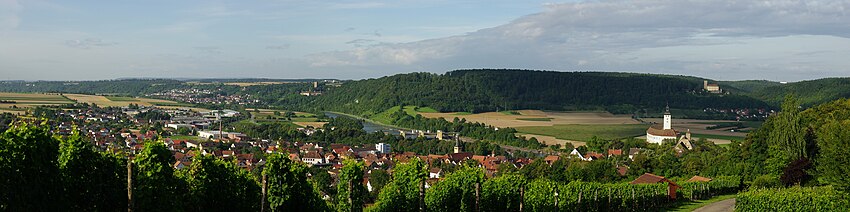
At Lauffen am Neckar the valley narrows between the Hypocritical mountain and the Löwensteiner mountains to join Heilbronn to open in the level of the Unterlandes. The Kraichgau With Bad Wimpfen is on the left, the tributaries flow on the right Stove and Chasing at Bad friedrichshall
Lower course
At Gundelsheim the Neckar leaves the former Württemberg Unterland and flows in a northerly direction. This part of the river is also called Electoral Palatinate Neckar referred to because the places on its banks were almost without exception in the former Electoral Palatinate, even if they belonged to Baden from 1806. The river has dug itself deep into the shell limestone that leads to the Kraichgau, on the right to the Building land belongs.
- Hassmersheim on the left side of the river is the southernmost municipality of the Neckar-Odenwald district
- Neckarzimmern Hornberg Castle dominates on the right bank. The neighboring towns Neckarelz and Diedesheim are districts of Mosbach, which is located at the entrance to the building land.
- Obrigheim on the left bank of the Neckar marks the transition from Kraichgau to small Odenwald. Then the valley narrows, instead of the shell limestone, the red sandstone of the rear Odenwald appears.
- Binau, Neckargerach and Zwingenberg lie on the right bank of the river.
Now the Neckar has finally reached the Odenwald. At Eberbach the river changes direction and flows west.
- Staghorn and Neckarsteinach on the right side of the Neckar are the southernmost Hessian communities
- Neckargemünd and Dilsberg Castle are on the left bank
- Heidelberg with its districts Schlierbach and Ziegelhausen forms the end of the Odenwald to the west.
Now the Neckar crosses the area of the Mountain road and arrives in the area of Rhine plain. At Ladenburg over it goes after Mannheimwhere the river flows into the Rhine.
Other goals
On the left bank of the middle Neckar are the gauze landscapes of Oberem Gäu, Strohgäu, Heckengäu, Stromberg, Zabergäu and Heuchelberg, which belong to the Keuperbergland. Are of tourist interest
- Leonberg in the Glemstal at the gates of Stuttgart
- Markgröningen in Glemstal and Strohgäu, known for the Shepherd run
- Boeblingen on the Upper Gäu and Schönbuch
- Sindelfingen in the Glemswald
- Because of the city in the Heckengäu
- Calw, Bad Liebenzell are already in the Black Forest
On the right bank of the river are the valleys of Fils and Rems in the Middle Alb foreland. Here are the places
The regions of Albuch and Härtsfeld follow to the east.
The Swabian-Franconian Forest follows further north.
background
 River view from Neckargemünd |
 View from the barrage Neckarsteinach |
 Staghorn: Old town with castle |
 Heidelberg with Berg Königstuhl at night |
The name Neckar is of Celtic origin and stands for wild water. Today the river is tamed by the numerous barrages and mostly flows calmly through the valley, past picturesque towns. Only occasionally does it show its old strength and danger, which is also proven by high water marks from more recent times. Examples can be found in abundance along its banks, such as on Meat and court house in Heilbronn or at a number of places close to the river Heidelberg Old town. In Heidelberg he still remembers today Hack devil of the dangerousness of the river. These are shallows that caused treacherous currents before the water was dammed up at the lock near Heidelberg. Today remember the name of one Water sports clubs and a cozy Old town hotel with wine bar to the former danger.
The earlier unpredictability of the Neckar is also proven by that Neckar privilege from 1333, which allowed the city of Heilbronn to use the course of the river at its own discretion. This enabled Heilbronn to control rafting on the Neckar. But raft money was not only levied in Heilbronn. This was forbidden in 1832 by the Neckar Shipping Ordinance. The first steamships soon appeared on the Neckar, but the river did not really become a waterway until after 1878 through a chain that lay on the bottom of the river for a length of 115 km between Mannheim and Heilbronn and along which the river Chain tractor their barges pulled up the river. After 11 barrages were initially built between Mannheim and Heilbronn from 1935, chain shipping was discontinued. The middle course of the Neckar was only made navigable after the Second World War. The port of Stuttgart was put into operation in 1958, the last barrage at Deizisau was built around 10 years later.
| place | River kilometers | Height above sea level |
|---|---|---|
| Deizisau | 199,5 | 247,2 |
| Oberesslingen | 194,8 | 242,1 |
| Esslingen | 194,0 | 236,2 |
| Obertürkheim | 189,5 | 231,0 |
| Untertürkheim | 186,7 | 222,65 |
| Cannstatt | 182,7 | 219,0 |
| Hofen | 176,2 | 213,6 |
| Aldingen | 171,4 | 206,8 |
| Poppenweiler | 165,0 | 203,2 |
| Marbach | 157,6 | 196,2 |
| Pleidelsheim | 150,1 | 190,2 |
| Hessigheim | 143,0 | 182,2 |
| Besigheim | 136,2 | 176,9 |
| Lauffen | 125,1 | 169,2 |
| Horkheim | 117,5 | 161,3 |
| Heilbronn | 113,6 | 154,0 |
| Kochendorf | 103,9 | 150,8 |
| Gundelsheim | 93,8 | 142,8 |
| Neckarzimmern | 85,9 | 138,6 |
| Guttenbach | 72,2 | 133,0 |
| Rockenau | 61,4 | 127,7 |
| Staghorn | 47,7 | 121,7 |
| Neckarsteinach | 39,3 | 116,4 |
| Neckargemünd | 30,8 | 111,7 |
| Heidelberg | 26,1 | 107,6 |
| Schwabenheim | 17,7 | 105,2 |
| Feudenheim | 6,2 | 96,5 |
| Muzzle into the Rhine | 0 | 86,5 |
language
One speaks in Baden-Württemberg German, not necessarily high German. In the Neckar Valley you can get to know a whole range of these dialects: alemannic at the source, Swabian in the middle Neckar area, and Electoral Palatinate near the mouth. In addition, there are countless tonal variations graded, which are not necessarily understandable to a stranger. They are a specialty Gôgen, whose language and nature are in the Gôgen joke expresses.
But do not worry: Swabians and Badeners are mostly business-minded. As crude as they sound, they will treat strangers well because otherwise you can't do business with them.
getting there
In the street
The Neckar Valley is crossed by several motorways:
- The A 6 comes from Frankfurt and crosses the Neckar near Mannheim, leads through the Kraichgau, crosses the Neckar again at Heilbronn, and continues to follow Nuremberg.
- The A 81 leads from Wurzburg at Ludwigsburg and at Villingen-Schwenningen over the Neckar and further on To sing to Lake Constance.
- The A 8 traversed by Karlsruhe the Black Forest and leads to Stuttgart via Stuttgart Ulm and further after Munich.
By train
The Neckar cities of Stuttgart, Heidelberg and Mannheim are stops for ICE trains. There is practically a railway connection from the mouth to the source, so that traveling by train is problem-free.
By bicycle
The Neckar is accompanied by that Neckar valley cycle path
By boat
The Rhine-Neckar passenger shipping runs with the in summer White Fleet of Worms to Eberbach. There are also regional passenger lines around Heilbronn and Stuttgart. A continuous connection is currently not available.
By plane
Stuttgart Airport is centrally located above the Neckar Valley.
mobility
Tourist Attractions
Along the Neckar there are numerous villages and towns that are well worth seeing, their silhouettes are often dominated by castles and palaces. This is especially true for the lower reaches, where Heidelberg is an example of a tourist destination with romantic nooks and crannies and the castle is known all over the world. This is followed by the self-proclaimed "romantic four" Neckargemünd, Neckarsteinach, Staghorn and Eberbach. The historic walls come into their own thanks to the picturesque mountain slopes and deeply cut valleys.
- The Neckarsteig is a quality long-distance hiking trail, it stretches over 126.4 km from Heidelberg to Bad Wimpfen, it leads over long stretches along the river, then changes back to the other side of the river, goes through the woods up into the Odenwald and then opens up a view of the picturesque valleys.
activities
kitchen
nightlife
security
climate
literature
Web links
- The Neckar Magazine: www.neckar-magazin.de.
- The Neckar pebble