The Strohgäu is a landscape space in Baden-Wuerttemberg.
Regions
The Strohgäu too Lower Gäu called, is northwest of Stuttgart. In the north, the Enz forms the border to Stromberg, in the west it turns into that Heckengäu. In the south, the Strohgäu borders on the Korngäu and to the foothills of the Schönbuchs. In the east, the Lange Feld merges into the Neckar basin. The Strohgäu is traversed by the Glems, which rises at Schloss Solitude in Stuttgart-Weilimdorf and flows into the Enz.
The originally quite rural region has changed a lot in the last few decades, it is relatively densely populated, characterized by industry and trade, and well developed in terms of transport, which is not least due to its proximity to the state capital Stuttgart.
places

- 1 Asperg


 in the Wikidata database") - the city is dominated by the old Hohenasperg fortress
- the city is dominated by the old Hohenasperg fortress - 2 Eberdingen - Prince's grave and Celtic museum in the Hochdorf district
- 3 Gerlingen
- 4 Markgröningen - known from the annual shepherd run
- 5 Korntal-Münchingen
- 6 Ludwigsburg - 7 Pflugfelden
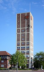
- 8 Kornwestheim - City hall and water tower under one roof, Salamander city park
- 9 Ditzingen
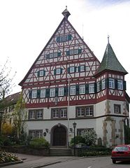
- 10 Leonberg - Market square with the half-timbered houses, bitter orange garden at the castle
- 11 Schwieberdingen
- 12 Weissach
- 13 Hemmingen (Württemberg)
- 14 Possible
- 15 Heimerdingen
- 16 Rutesheim
- 17 Vaihingen an der Enz
- 18 Tamm
- 19 Freiberg am Neckar
- 20 Oberriexingen


Other goals
background
Glemsgau
language
Swabian
getting there
The eastern edge of the Strohgäus can be reached from the A81 from the connection points ![]() 15 - 18. Also crosses the B10 the region on its way from Pforzheim to A81 and after Stuttgart.
15 - 18. Also crosses the B10 the region on its way from Pforzheim to A81 and after Stuttgart.
mobility
Tourist Attractions
- The Fiery Elias, a museum train of the Society for the maintenance of rail vehicles runs repeatedly on the Strohgäubahn route in summer
activities
- The Celtic way is an approx. 30 km long cycle path, it leads past the most important sites of Celtic culture
- The Glemsmühlenweg is a 40 km long cycle path through the Glemstal past 19 mills