


The North Sea is a popular one Shelf sea (Wikipedia article) in northern Europe. It is limited by Scandinavia in the east of North and Central Europe in the south and Western Europe with the British Isles to the west. To the north the North Sea goes into the Atlantic ocean above. To the east it is via the Skagerrak and Kattegat with the Baltic Sea connected, in the southwest is the busy English Channel.
Regions


Coastal regions
- German North Sea coast
- Scandinavian North Sea coast
- Continental North Sea coast
- British North Sea coast
Islands
- 1 Heligoland


 in the Wikidata database")
- 2 North Frisian Islands
- 3 East Frisian Islands
- 4 West Frisian Islands (Nederlandse Waddeneilanden)
- 5 Great Britain (Great Britain)
- 6 Channel Islands (Channel Islands)
- 7 Orkney Islands
- 8 Shetland Islands


links
- 1 Skagerrak
- 2 Kattegat
- 3 English Channel (English Channel)


Great tributaries
- Glomma (Norway)
- Skjern Å (Denmark)
- Elbe
- Weser
- IJsselmeer
- Rhine/ Meuse
- Scheldt
- Thames
- Moray Firth (Scotland)
- Firth of Tay (Scotland)
Riparian states and cities
Clockwise with the major coastal metropolises:
- Norway
- Sweden
- Gothenburg (is already in the Kattegat)
- Denmark
- Germany
- Netherlands
- Belgium
- France
- Great Britain
Other goals
- 10 IJsselmeer
- 11 Kiel Canal
- 12 Baltic Sea
- 13 Zeeland

.jpg/240px-North_Holland,_Flevoland_and_parts_of_Friesland_by_Sentinel-2,_2018-06-30_(small_version).jpg)


background
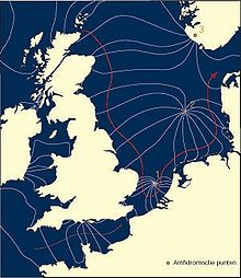
The North Sea is a relatively shallow sea with sandbanks and some deeper gullies. The tides are triggered by the water masses of the Atlantic and run from the north into the North Sea. The tidal range is very different from about 0.5 meters on the Norwegian coast to almost 7 meters in the English Wash, it is also influenced by the wind and the shape of the coast. In the case of the funnel-shaped constrictions of the major rivers (Thames, Rhine, Elbe) and the corresponding storm, it increases considerably. Conversely, the volume of water from the large rivers press against the incoming tide and can lead to backwater above.
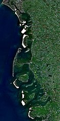
The coastal strip along the North Sea is also very different. There are deep cuts on the Norwegian coast Fjords with partly rugged mountain slopes. In the Skagerrak and Kattegat are Skerries, small, flat islands off the coast. Denmark has Cliffs, Sand dunes and already islands in the Wadden Sea which continues on the German and Dutch North Sea coast. The coast of the Netherlands and Belgium are great by the River deltas dominated by the Rhine / Maas and the Scheldt. In France and the south of England there are cliffs again, the most famous formation is probably the white limestone cliffs Dover. Further north up the coast to Scotland, the coast was shaped by ice ages, similar to Scandinavia, but it was formed here Fjärde. These are flat, wide bays, often with small, offshore islands.
Land reclamation is mainly carried out on the Dutch coast, here that was IJsselmeer (the former Zuidersee) separated from the North Sea. Practically all neighboring states protect their land, examples of which are the Halligen in Germany and the weirs in the Osterschelde or Thames. Storm surges occur when the tide meets the corresponding wind directions and strengths. The coasts of the Netherlands, Belgium, Germany and Denmark are particularly at risk. In earlier centuries, the floods reshaped the coastal strip, newer storm surges such as the Holland storm surge in 1953 or the Hamburg storm surge in 1962 have led to increased efforts in dike construction and coastal protection, which has proven itself in 1990, for example. In February of this year, one wind tide, two hurricanes and two storm surges hit the German North Sea coast within three days and only caused property damage. For visitors to the coasts, the safety measures often also represent sights, technical structures can be viewed, dikes can be hiked or cycled, the beach grass that protects the dunes sways in the wind.
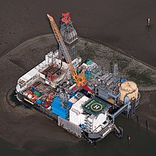
The North Sea is criss-crossed by important trade routes that have been in operation for centuries. Bergen, London and Bruges were important trading cities of the Hanseatic League, which otherwise concentrated on the Baltic Sea. The shallow sea, rich in kelp and nutrients, was and is a good fishing ground for the fishing fleets. As a result, large port and trading cities emerged on the coasts. The area between Hamburg and Brussels is heavily industrialized, especially heavy industry has settled and uses the inexpensive transport options offered by ocean shipping. On the sea itself there is now also industrial use, so wind farms are planted off the coast and there and in the middle of the North Sea there are a number of drilling rigs that develop natural gas and oil deposits.
In the 19th century the recreational and recreational value of the lake was discovered and glamorous bathing resorts and health resorts emerged. While initially only well-heeled people could afford a beach holiday, there is now a wide range of options for all price categories, from simple camping holidays in the dunes to guest houses and holiday homes to historic bathing hotels equipped with modern service facilities. Some health resorts also use the North Sea climate as well as sea water, silt, algae and sea salt as remedies.
Around 80 million people live along the coastal strip around the North Sea. In Belgium, the Netherlands and Northern Germany in particular, the coast is densely populated with large cities or a cluster of cities such as the Randstad.
language
The exact language distribution can be found in the respective country articles. The Norwegian, Danish, Low German, German, Frisian, Dutch, Flemish, French, English and Gaelic languages are at home on the coasts of the North Sea.
getting there
see the neighboring countries and cities.
mobility
There are regular flight connections between major cities such as Aberdeen, Edinburgh, London, Brussels, The Hague, Bremen, Hamburg, Oslo, Bergen, etc. Many cities are also integrated into the European rail network, including London through the Channel Tunnel.
There are ferry connections from France, Belgium and the Netherlands to Great Britain:
- Ijmuiden-Amsterdam - Newcastle (daily, 3 p.m.)
- Rotterdam - Hull (daily, 12 h)
- Hook of Holland - Harwich (2 * daily, 8 h)
- Zeebrugge - Hull (daily, 12 h)
- Ostend - Ramsgate (3 * daily, 4 hours)
- Dunkerque - Dover (several times a day, 2 hours)
- Calais - Dover (several times a day, 1.5 hours)
- as well as other ferries in the English Channel
The Eurotunnel between France and England is served by trains that also transport motor vehicles.
Ferries to the islands:
- Aberdeen to Kirkwall on Orkney (several times a week, 6 hours)
- Aberdeen after Lerwick in the Shetlands (daily, 3 p.m.)
- Scrabster to Stromness on Orkney (2 * daily, 2 hours)
- Kirkwall on Orkney to Lerwick in the Shetlands (several times a week, 8 hours)
- the Shetland Islands are connected to each other by several ferries
- to the West Frisian and East Frisian Islands look there
- Heligoland is approached from Bremerhaven, Büsum, Cuxhaven, Hamburg, Wedel and Wilhelmshaven. The frequency depends on the season, the journey time is between 1.5 hours (fast ferry from Cuxhaven) and 4 hours (from Hamburg).
- to the North Frisian Islands look there
Scandinavia:
- a cross connection of Esbjerg (Denmark) to Harwich (Great Britain) (several times a week, 6 p.m.)
- Hirtshals - Kristiansand (2 * daily, 3 hours)
- Hirtshals - Langesund (daily, 5-6 hrs)
- Hirtshals - Stavanger (depending on the season 3 to 7 * a week, 12 noon)
- Hirtshals - Bergen (depending on the season 3 to 7 * a week, 4 p.m.)
- Oslo is approached from Frederikshavn, Kiel and Copenhagen
- Gothenburg is approached from Frederikshavn and Kiel
- between Strömstad (Sweden) and Sandefjord (Norway) there is a cross connection (several times a day, 2.5 hours)
- Stavanger - Haugesund (several times a day, 1.5 hours)
- Stavanger - Bergen (1 to 2 * daily, 5 hours)
- the Hurtigruten depart from Bergen along the Norwegian coastline to the north
Tourist Attractions
- Coastal formations such as fjords, fjords, archipelago islands, cliffs, Wadden Sea, etc.
- Old seafaring and fishing villages, seaside resorts, Hanseatic cities
- Technical structures for coastal protection
activities
- water sports: Sailing, fishing, surfing, kite surfing, diving
- Cycling on the international North Sea Cycle Route
- Hiking on foot on the North Sea Trail
kitchen
The coastal regions are naturally strong from Fish dishes embossed.
nightlife
security
health
Jellyfish

Most of the time the jellyfish that you meet while swimming are harmless. However, encountering a fire jellyfish can be very uncomfortable. Their tentacles, some several meters long and almost invisible, cause reddening and burning of the skin with their poison on the human skin. Fire jellyfish are orange, up to 1 m tall, with a flat umbrella and long tentacles and occur in the North Sea and Baltic Sea. It is best to avoid the jellyfish while swimming.
After contact with a fire jellyfish, the affected areas should be treated with vinegar or shaving foam. Carefully scrape off any threads and tentacles, for example with a plastic card or with sand or salt water.Under no circumstances wash off with fresh water or alcohol. Then apply burn ointment or anti-allergic ointment and see a doctor if you feel unwell or have allergic reactions.
climate
- Water temperatures for the German Bight - Website of the Federal Maritime and Hydrographic Agency