
The North Frisian Islands and Halligen lie in the North Sea in the district of North Friesland in Schleswig-Holstein (a state of Germany). You will be dated Schleswig-Holstein Wadden Sea National Park enclosed, but are not themselves included.
Geographically, the Danish Wadden Islands counted to the North Frisian island chain, but this article only deals with the German North Frisian islands.
Islands and Halligen
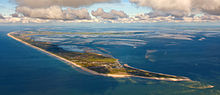
- Islands (from north to south)
- Sylt
- Foehr
- Amrum
- Pellworm
- North beach (a peninsula since 1987, but is traditionally still counted among the North Frisian Islands)
- Halligen

- Hallig Hooge - most famous Hallig; Destination of many day tourists Schlüttsiel and Nordstrand (port: Strucklahnungshörn).
- Langeneß -, largest, about 10 km long Hallig. Accessible with the Hallig ferry from Schlüttsiel out. There is also a non-public wagon train connection from Dagebüll via Oland to Langeneß.
- Oland - reachable by ship from Schlüttsiel. There is also a non-public Lorenbahn connection to the mainland Dagebüll and after Langeneß.
- Hallig Gröde - small Hallig with only 17 inhabitants, but some holiday apartments (info)
- Habel - Small, uninhabited Hallig with just 6 hectares that are not allowed to be entered. The strictly protected bird island is only looked after by a bird warden from the Jordsand Association, who lives in the only building visible from afar on a small terp.
- Hamburger Hallig - The connecting dam (Spurplattenweg) on the foreland at Sönke-Nissen-Koog is passable / walkable in normal tide Rental bicycles are available at the landside access to the dam in the Amsinckhaus. Parking is available there.
- Nordstrandischmoor - Accessible by ship for day visitors (depending on the tide). Holiday guests with overnight stays are driven by the landlords from the mainland to the island via the non-public lorry railway connection (Island side). The island can also be reached via a 3.5 km long mudflat hiking trail (access from the land: Lüttmoorsiel im Beltringharder Koog).
- Norderoog
- Süderoog
- Südfall - is only accessible by guided mudflat hike or by horse-drawn carriage on an organized tour. Otherwise the island, inhabited by two islanders but protected, may not be entered.
background

language
On the German North Frisian Islands, a regionally colored High German is usually spoken. In addition, many islanders also speak Low German, especially on Amrum and Föhr in many places still North Frisian, especially on Föhr and Sylt partly also Danish. Due to the geographically isolated location of the islands and the lack of a linguistic center, several North Frisian dialects have emerged such as Hallig Frisian, Föhrer and Amrumer Frisian (Fering and Öömrang) and Sylt Frisian (Sölring). In addition, there is Danish, which is mostly spoken in the southern Schleswig-Danish variant. There is also a Danish school on Föhr and Sylt. Up until the 17th and 18th centuries, North Frisian was also widespread on Eiderstedt and the island of Strand (today divided into Pellworm, Nordstrand and Nordstrandischmoor by storm surges), while Sønderjysk (Plattdan) was also spoken in the northern part of the island of Sylt.
Accordingly, Danish is spoken on the Danish Wadden Sea Islands, partly as Imperial Danish (Standard Danish) and partly as regional Jutland dialects (Sønderjysk and Vestjysk).
getting there
By plane
Sylt has one own airport![]()
![]()
![]()
![]() (IATA: GWT), which - mainly during the summer season - is approached from various airports in Germany and Switzerland.
(IATA: GWT), which - mainly during the summer season - is approached from various airports in Germany and Switzerland.

Have further Foehr and Pellworm smaller airfields (airfields) for smaller machines or helicopters without line connections.
The nearest international airport with numerous (also international) connections is the Hamburg Airport. From there it is by car (depending on the respective travel destination on the islands and Halligen (distance / travel time (calculated using OSM GraphHopper) to the mainland access in):
- Nordstrand (access to Nordstrander dam): 154 km / 1h43m,
- Pellworm / southern Halligen (access to Strucklahnungshörn harbor): 169 km / 1h58m,
- Sylt (access to the car terminal to Sylt): 189 km / 2h01m,
- northern Halligen (e.g. Hooge / Langeneß) (access to the ferries in Schlüttsiel): 190 km / 2h01m,
- Dagebüll (departure of the ferries to Föhr and Amrum): 198 km / 2h15m.
By train
Sylt is the only island that can be reached directly by train via Hindenburgdamm. Regional express trains go there every hour from Hamburg-Altona via Itzehoe, Husum and Niebüll. Several times a day there are also intercity connections, some from Berlin, some from Cologne via the Ruhr area and from Frankfurt a. M. come.
To get to Amrum or Föhr, travelers in Niebüll have to change to the regional train (neg) to Dagebüll and then change to the ferry. Intercity connections to and from Sylt usually have a coach service in Niebüll in the direction of Dagebüll.
The closest train station for Nordstrand is Husum, for the northern Halligen (e.g. Hooge or Langeneß) Bredstedt. There are regular bus connections from both train stations to the respective islands and Halligen.
From Denmark there is a regional train every hour or two from Esbjerg via Tønder to Niebüll, where you can change trains in the direction of the islands, as described above.
In the street
You can approach the region from the direction of Hamburg either via the A7 (E45) motorway in the direction of Flensburg, which you can choose between Schleswig / Schuby and Flensburg / Harrislee or via the A23 to Heide and then continue on the B5 towards Husum / Niebüll.
Motorized individual traffic is permitted on the main islands and larger Halligen (Langeneß, Hooge); they can be reached partly by car ferries (Amrum, Föhr, Pellworm, Langeneß, Hooge), partly by car loading onto the railroad (Sylt) or only at low tide (Hamburger Hallig ). However, there are only a few, very narrow streets on the Halligen, which is why guests are strongly recommended to park their cars on the mainland.
By boat
Most of the islands have ports or ferry docks.
- Dagebüll for the car ferry to Foehr and Amrum.
- Strucklahnungshörn for the car ferry to Pellworm. Excursions without car transport are available to the Hallig Hooge, Island Amrum and to Hörnum Sylt.
- Schlüttsiel for the car ferry to Hallig Hooge, Hallig Langeneß and island Amrum. There are also excursions to the Hallig Gröde and to the Hallig Oland.
mobility
Some islands and Halligen are connected by ferry or speedboat lines. You can even go further on foot (mudflat hike), e.g. B. from Foehr to Amrum. A mudflat hike should only be carried out in the company of local residents or professional mudflat guides. - For more information, see also the page of the Association of mudflat guides in the Schleswig-Holstein Wadden Sea National Park).
Tourist Attractions
- 1 West Coast Art Museum, Hauptstrasse 1, Alkersum.
activities
kitchen
nightlife
security
climate
- Water temperatures, tides, etc. - Website of the Federal Maritime and Hydrographic Agency (the locations can be selected in the selection to the right of the map, alternatively you can also click directly on the map).
trips
literature
Web links
- Schleswig-Holstein Wadden Sea National Park - in this are the North Frisian Islands.