 | ||
| Taunus | ||
| federal state | Hesse | |
|---|---|---|
| Residents | unknown | |
| no value for residents on Wikidata: | ||
| height | 878 m | |
| no tourist info on Wikidata: | ||
| location | ||
| ||

The Taunus is a German low mountain range.

Regions
- Vordertaunus.

 in the Wikidata database") densely populated region on the southern Taunushang in the transition to the Rhine-Main area. The wealthy from the Rhine-Main area like to live here. Worth seeing are among others. Koenigstein with its imposing castle ruins, Kronberg with Opel zoo and old town and the spa town bad Homburg with its castle, the castle park and the extensive spa park. The Neroberg Wiesbaden also attracts many visitors. Another goal is also Eppstein with its castle ruins.
densely populated region on the southern Taunushang in the transition to the Rhine-Main area. The wealthy from the Rhine-Main area like to live here. Worth seeing are among others. Koenigstein with its imposing castle ruins, Kronberg with Opel zoo and old town and the spa town bad Homburg with its castle, the castle park and the extensive spa park. The Neroberg Wiesbaden also attracts many visitors. Another goal is also Eppstein with its castle ruins.
- Hochtaunus. This region includes on Wikivoyage the extended massif of the Great Feldberg with its foothills between Königstein and Neu-Anspach in a north-south direction as well Idstein and bad Homburg / Friedrichsdorf in the west-east axis. The wooded ridge of the Hochtaunus is largely uninhabited except for the smaller districts of the communities Schmitten and Glashütten. A much-visited destination here is the 880 m high as the highest mountain in the Taunus Great Feldberg. Other well-known destinations are the reconstructed Roman fort Saalburg and the extensive open-air museum Hessenpark on the subject of "Half-timbered buildings in Hessen".
- Rheingau Mountains. The "backbone of the Rheingau" forms together with the much-visited Rheingau a tourist region. The most beautiful vantage point is the Niederwald monument at Rudesheim. If you want to escape the hustle and bustle of the great sights in the Rheingau on beautiful excursion days, you should set off on a hike or a sporty bike tour in the Rheingau mountains. For more about the sights see article Rheingau.
- Eastern Hintertaunus. The eastern Hintertaunus begins roughly at the height of Neu-Anspach / Usingen and extends to the north in the north Lahn valley. The western border forms the narrow valley of the Goldener Grund. The Cologne - Frankfurt am Main transport axis with the A3 motorway and the ICE route is also located here. Points of attraction are z. B. Weilburg with its castle and the Lahn valley for paddling tours. If you want to explore the region by bike, you can use the Weiltalweg follow the course of the Weil from the Hochtaunus to the Lahn valley. At the weekend, a bicycle bus provides a comfortable ascent. Is also worth seeing Limburg on the Lahn with cathedral and half-timbered old town.
- Western Hintertaunus. The western Hintertaunus is formed by the Lahn valley in the north, the upper one Middle Rhine Valley in the west, the Rheingau Mountains in the south and the Goldener Grund in the east. The core of this region is still largely off the beaten track, especially in the Rhineland-Palatinate part. Here there is a lot of peace and quiet and a green low mountain range to discover away from the big visitor magnets of the Rhine and Lahn valleys. In the Hessian part lie with Bad Schwalbach and Schlangenbad are well-known health resorts. Hohenstein Castle in the Aartal is one of the largest castle ruins in the mountains.
Nature parks

There are three nature parks in the Taunus region:
- 1 Hochtaunus Nature Park.
 This park includes the actual Hochtaunus with the Großer Feldberg and large parts of the eastern Hintertaunus. The park has been operating the in Oberursel-Hohemark since 2011 "Taunus Information Center", which can be found in the area of the Hohemark subway terminus. In the center there is an adventure exhibition about the mountains. Nature park side. The Taunus is well developed for hikers. Most of the trails are well signposted and easy to walk. The silence of nature is often disturbed by loud motorbikes that drive the route to the Feldberg, especially on weekends.
- 2 Rhine-Taunus Nature Park. This nature park is located in the western Hintertaunus of Hesse and also covers the Rheingau mountains. Nature park side.

- 3 Nassau Nature Park. This nature park covers all parts of the Hintertaunus that are too Rhineland-Palatinate belong. Furthermore, parts of the Lahntals, of Middle Rhine Valley and large parts of the Westerwaldes to the park. Nature park side.

places

- 1 Bad Camberg
 . Kneipp spa.
 - 2 bad Homburg.

 largest city in the region with a castle, castle park, extensive spa park, fountain and Siamese temple. Your motto is Champagne air and tradition. The reconstructed one stands on the ridge height and the former Limes Saalburg Castle.
 - 3 Bad Nauheim. Health resort with a beautiful health resort park, drinking facilities, magnificent bathing houses and old salt production facilities.
- 4 Bad Schwalbach. Spa town.
- 5 Braunfels. with the castle and the half-timbered houses on a mountain.
- 6 Eppstein. Ruins of Eppstein Castle, Imperial Temple.
- 7 Friedrichsdorf. The city of the Huguenots and the telephone inventor Philipp Reis.
- 8 Hasselbach. Half-timbered houses, baroque church, inns, bird castle, hiking trails.
- 9 Idstein. a medieval town, known for the annual jazz festival.
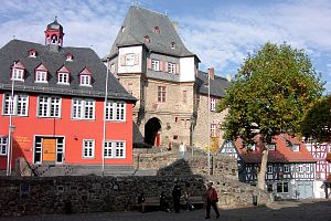
- 10 Koenigstein. with one of the largest castle ruins in Germany.
- 11 Kronberg. winding old town streets, half-timbered houses and a castle.


At the edge of the Taunus:
- 12 Bad Ems. magnificent buildings on the Lahn.
- 13 Limburg on the Lahn. The cathedral and half-timbered old town between the Westerwald and Taunus lies in the Lahn valley.
- 14 Weilburg. numerous half-timbered houses and a renaissance castle on the mountain in the city.
- 15 Wetzlar. In the former imperial city, Goethe worked as a lawyer at the imperial court in 1772.
- 16 Wiesbaden. The state capital and former world spa town with its well-preserved buildings of historicism is located on the southern edge in Rheingau near the Rhine.


Other goals
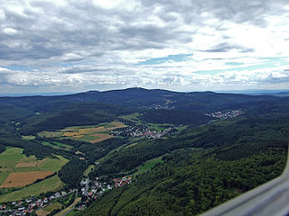
- 1 Great Feldberg. at 880 m the highest mountain in the Taunus.
- 2 Saalburg Castle, Saalburg 1, 61350. how people imagined Roman life at the Germanic border post more than 100 years ago.
- 3 Hessenpark. old half-timbered buildings from the region rebuilt in one place.
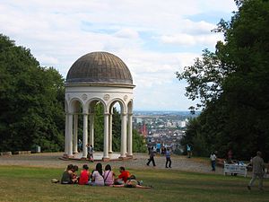
- 4 Neroberg. with the water-powered funicular Wiesbaden Enjoy the local mountain on the edge of the Taunus and the wide view as far as Mainz. A swimming pool and a Russian chapel also attracts visitors to the mountain.


On the edge of the Taunus
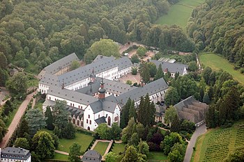
- 5 Eberbach Monastery. at the top of the Rheingau.
- 6 Niederwald Monument. and the St. Hildegard Abbey at Rudesheim.
- 7 Loreley. in the world cultural heritage of the upper Middle Rhine Valley.
- 8 Lahn valley. With Bad Ems, Limburg on the Lahn and Weilburg.
- 9 Rhine-Main Regional Park


Mountain peaks with a beautiful view
- Rheingau Mountains: Rheingauer Alp near Presberg · Teufelskadrich near Assmannshausen · Hallgartner Zange · Bubenhäuser Höhe near Rauenthal in the Rheingau · Hallgarter Zange lookout tower · Spitzer Stein and Goethestein lookout point near Wiesbaden-Frauenstein
- Bad Schwalbach State Forest: Schwalbacher Höhe with observation tower · Geisberg and Röderkof bei Heidenrod · Atzmann bei Dickschied
- Wiesbaden city forest: Schläferskopf (tower cannot be climbed due to the risk of collapse) Neroberg · Cellar head
- High Taunus: Great Feldberg - Herzberg (591 m) with gastronomy between Großer Feldberg and Saalburg Castle with a 24.50 m high stone tower. - Horse head (663 m) near Treisberg in the municipality of Schmitten with a 34 meter high observation tower.
background
The Taunus is particularly attractive thanks to its Hochtaunus Nature Park. The highest point is the 880 m high Great Feldberg. The low mountain range lies between Wetterau, Rheingau, Middle Rhine Valley and the Lahn valley, it is mostly in Hesse and extends to after Rhineland-Palatinate into it.
getting there
The Taunus can be easily reached by all means of transport. The Autobahn takes you from the A5 and A661 to Bad Homburger Kreuz.
Regional express trains run from Frankfurt am Main via Hofheim to Niedernhausen, Idstein, through the "Goldenen Grund" via Bad Camberg in the direction of Limburg a. d. A regional train runs from Wiesbaden to this route. S-Bahn trains from Frankfurt am Main go to Niedernhausen, Bad Soden, Kronberg and Friedrichsdorf (via Oberursel and Bad Homburg). Regional trains run to Königsstein and via Usingen in the Hintertaunus to Brandoberndorf. The edges of the Taunus are served by the Rhinegau line Frankfurt am Main - Wiesbaden - Lahnstein - Neuwied and the Lahntalbahn Koblenz - Limburg - Wetzlar - Gießen.
The website of the is recommended for timetable information for buses and trains RMV.
The nearest airport is that Frankfurt am Main airport.
activities
hike
- Hessenweg 1. The somewhat incomplete signage leads us from the Diemelsee on the edge of the Sauerland to the Wiesbaden Rheingau - a route full of wonderful nature, grown culture and imposing castles and palaces.
- Hessenweg 7. .It leads from Kaub in the Rhineland-Palatinate Loreley-Burgen-Land through the Rheingau past the Niederwald monument with the Germania near Rüdesheim to the Hessian capital Wiesbaden. From Biebrich Castle, Hessenweg 7 heads south over the Mainspitze into the Hessian Ried, comes to the Bergstrasse via Pfungstadt and follows it to Bensheim before heading east through the Odenwald to the destination in Erbach.
- Rheinsteig. including the signposted access routes.
- Rheinburgenweg. is still partially signposted on the right bank of the Rhine, but has been officially restricted to the left bank of the Rhine for years. Its route was very similar to that of the Rheinsteig.
- Rheinhöhenweg. is inadequately maintained.
- Taunushöhenweg. .The Taunushöhenweg corresponds to the course of the European long-distance hiking trail E3, which connects the two UNESCO World Heritage sites Upper Middle Rhine Valley and Upper Germanic-Raetian Limes as well as the two nature parks of the low mountain range, the Rhine-Taunus Nature Park and the Taunus Nature Park.
- Gebückwanderweg. is a 50-kilometer hiking trail in the Rhein-Taunus Nature Park. Beginning in Niederwalluf, it roughly follows the course of the old Rheingauer Gebück Landwehr to the mouth of the Wisper in Lorch.
- Aar high trail. .The route (60km) of the Aarhöhenweg leads from the source of the Aar in the city forest of Taunusstein-Orlen through beautiful forests and over fields to the confluence with the Lahn near Diez. Along the route are the beautiful and worth seeing Taunus towns of Hohenstein, Heidenrod and Aarbergen.
- Limes hiking trail
- Wisperwanderweg
- Lahn-Camino. Pilgrimage route along the Lahn - it is almost identical to the one on the left Lahnhöhenweg and partly with the Lahn hiking trail.


To go biking
- Hess. Long-distance cycle route R6: From Waldecker Land into the Rhine Valley
- Hess. Long-distance cycle route R8: Westerwald - Taunus - Bergstrasse
- Weiltalweg - From the Weilquelle below the Great Feldberg to Lahn at Weilburg
- Limes cycle path
- Aartal - from Taunusstein via Hahnstätten to Lahn in Diez
- Eisenstrasse Feeder to Aartal cycle path (Taunus) on mountain trails, Cycle route planner
- Ems and Wörsbachtal cycle path (Bad Camberg) − Combinable cycle paths from Bad Camberg, or an alternative route to the R8
- Loreley-Aar cycle path - From Hanststätten to St. Goarshausen on the Rhine
- closed to motorized traffic. Then inline skaters, bikers and everything else that moves with muscle power have a carefree ride.
Winter sports
- Current winter sports information:
- - Snow Telephone: 06081-442138,
- - Current snow depth on the Großer Feldberg via Wetteronline.de
- - Trail report of the Hochtaunus Nature Park
- Trails - In addition to the "Taunus ski hiking trail", local cross-country trails are also groomed through the nature park in the Hochtaunus. In total there are around 50 km of connected cross-country trails in the Hochtaunus. A few circular courses are groomed from the sand slab. Unfortunately, pedestrians damage the lanes heavily on busy weekends. The Trail report with detailed information on the routes is on the nature park website to find.
- Taunus cross-country ski trail - The groomed high-altitude trail leads from Saalburg Castle over the Feldberg massif to Rod an der Weil. The path leads north past the Feldberg (section Sandplacken - Red Cross.) From the Red Cross (on the small Feldberg) the trail turns north and uses the western ridge of the Weiltal. If the snow conditions are good, the ski hiking trail ends in Rod an der Weil.
- Alpine skiing - There are also some smaller ski lifts in the Taunus. For more, see lift information on the page of the Taunus Touristik Service.
kitchen
In the Taunus there are countless inns and restaurants that serve local (see Eating and drinking in Hessen) and offer international cuisine.
climate
Due to its proximity to the Rhine, Main and the Upper Rhine Plain, the Taunus is very mild compared to other mountains.
literature
- Etzel, Stefan: Hiking in the Taunus. Dumont Reiseverlag, Ostfildern 2013, ISBN 978-3-770180-318
- Compass hiking and biking map 839 "Westlicher Taunus", Scale 1: 50,000, 6.95 euros, ISBN 978-3-85491-137-1 , see also www.kompass.at
- Compass hiking and biking map 840 "Eastern Taunus", Scale 1: 50,000, 6.95 euros, ISBN 978-3-85491-138-8 , see also www.kompass.at
- Stahr, Alexander / Bender, Birgit: The Taunus - a journey through time - Origin and development of a low mountain range, 253 pages with numerous mostly colored illustrations, format: 24 x 17 cm, ISBN 978-3-510-65224-2 , Price: € 34.80 (hardback edition 2007)
Web links
- Taunus Touristik Service - official regional tourism site
- Rheingau-Taunus information - Official regional tourism website for the western Taunus in the Rheingau area